Albay
| Albay | |||
|---|---|---|---|
| Province | |||
| Province of Albay | |||
|
Albay Provincial Capitol in Legazpi | |||
| |||
 Location in the Philippines | |||
| Coordinates: 13°14′N 123°38′E / 13.23°N 123.63°ECoordinates: 13°14′N 123°38′E / 13.23°N 123.63°E | |||
| Country | Philippines | ||
| Region | Bicol Region (Region V) | ||
| Founded | April 3, 1574 | ||
| Capital | Legazpi | ||
| Government | |||
| • Type | Sangguniang Panlalawigan | ||
| • Governor | Francis Bichara (Nacionalista) | ||
| • Vice Governor | Harold Imperial (Liberal) | ||
| Area[1] | |||
| • Total | 2,575.77 km2 (994.51 sq mi) | ||
| Area rank | 53rd out of 81 | ||
| Population (2015 census)[2] | |||
| • Total | 1,314,826 | ||
| • Rank | 20th out of 81 | ||
| • Density | 510/km2 (1,300/sq mi) | ||
| • Density rank | 12th out of 81 | ||
| Divisions | |||
| • Independent cities | 0 | ||
| • Component cities | |||
| • Municipalities | |||
| • Barangays | 720 | ||
| • Districts | 1st to 3rd districts of Albay | ||
| Time zone | PHT (UTC+8) | ||
| ZIP Code | 4500–4517 | ||
| IDD : area code | +63 (0)52 | ||
| ISO 3166 code | PH-ALB | ||
| Spoken languages | |||
| Website |
www | ||


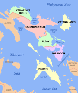
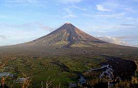
Albay (Central Bikol: Probinsya kan Albay; Filipino: Lalawigan ng Albay) is a province located in the Bicol Region in southeastern Luzon of the Philippines. Its capital is the city of Legazpi, the regional administrative center of the whole Bicol Region, which is located in the southern foothill of Mayon Volcano, the symbol most associated with the province. This perfectly symmetrical active stratovolcano forms a magnificent, scenic backdrop to the city of Legazpi and is visible throughout the municipalities and cities of Albay including the surrounding provinces.[3]
The province was added to the UNESCO World Network of Biosphere Reserves in March 2016.[4]
History
Pre-Hispanic period
Long before the Spaniards arrived, Albay had a thriving civilization. Formerly called Ibat, and then Libog, Albay was once ruled by Gat Ibal, an old chief who also founded the old barangay of Sawangan, now part of the city of Legazpi.
Spanish colonial period
In July 1569, Luis Enriquez de Guzman, a member of the expedition led by Maestro de Campo Mateo de Saz and Captain Martin de Goiti, led a group which crossed from Burias and Ticao islands and landed on a coastal settlement called Ibalon in what is now the province of Sorsogon. From this point another expedition was sent to explore the interior and founded the town of Camalig.
In 1573, Juan de Salcedo penetrated the Bicol Peninsula from the north as far south as Libon, establishing the settlement of Santiago de Libon. Jose Maria Peñaranda, a military engineer, was made “corregidor” of the province on May 14, 1834. He constructed public buildings and built roads and bridges.
The entire Bicol Peninsula was organized as one province with two divisions, Camarines in the northwest and Ibalon in the southeast. In 1636, the two partidos were separated, and Ibalon became a separate province with Sorsogon as capital. In the 17th century, Moro slave raiders from southern Philippines ravaged the northeastern coastal areas of the province of Albay.[5]
Mayon Volcano, in one of its most violent eruptions, destroyed the five towns surrounding its base on February 1, 1814. This eruption forced the town of Cagsawa to relocate to its present site, Legazpi.
A decree was issued by Governor-General Narciso Claveria in 1846 separating Masbate, Ticao and Burias from Albay to form the comandancia of Masbate. Albay was then divided into four districts: Iraya, Cordillera or Tabaco, Sorsogon and Catanduanes.
Philippine revolution
Glicerio Delgado, a condemned insurecto (insurgent), started revolutionary activities in the province. With a headquarters in the mountain of Guinobatan town, he joined the revolutionary government of Albay as a lieutenant in the infantry.
A unit of the Philippine Militia was then organized by the Spanish military authorities. Mariano Riosa was appointed major of the Tabaco Zone, which comprised all the towns along the seacoast from Albay to Tiwi while Anacieto Solano was appointed major for the Iraya Zone, which was made up of the towns from Daraga to Libon. Each town was organized into sections of fifty men under the command of a lieutenant.
During the Philippine Revolution on September 22, 1898, the provisional revolutionary government of Albay was formed with Anacieto Solano as provisional president. Major General Vito Belarmino, the appointed military commander, reorganized the Filipino Army in the province.
American colonial period
The sovereignty of the country was transferred to the United States after the Treaty of Paris (1898).[6] During the Philippine–American War, Brigadier General William August Kobbé headed the expedition that landed at the ports of Sorsogon, Bulan and Donsol. From there, the Americans marched to Legazpi and captured it.
Although a civil government was established in Albay on April 26, 1901, Colonel Harry Hill Bandholtz, Commanding Officer of the Constabulary in the Bicol Region, said that General Simeon Ola, with a thousand men, continued to defy American authority after the capture of Belarmino in 1901. Ola was later captured with about six hundred of his men.
World War II
Following the December 12, 1941 Japanese invasion of Legaspi during the Second World War, the Kimura Detachment of the Imperial Japanese Army occupied Albay Province. The region was defended only by the Philippine Constabulary unit under the command of Major Francisco Sandico.[7]
During the Japanese Occupation, the military general headquarters of the Commonwealth Army of the Philippines remained active from January 3, 1942 to June 30, 1946, and the 5th Infantry Regiment of the Philippine Constabulary was established from October 28, 1944 to June 30, 1946 and stationed in Albay. Then came the clearing operations and anti-Japanese insurgency in the Bicol Peninsula, helped by the local Bicolano resistance. Some Bicolano guerrilla groups invaded around the province of Albay during the Japanese Insurgencies between 1942 and 1944, and were supported by local Filipino troops under the Philippine Commonwealth Army and pre-war Philippine Constabulary 5th Infantry Regiments attacking the enemy soldiers of the Japanese Imperial Army. In the aftermath of three years of siege and conflicts, many Bicolano guerrillas were forced to retreat by the Japanese around the province before liberation in 1945 by Allied forces.
In 1945, Filipino soldiers of the 5th, 51st, 52nd, 54th, 55th, 56th and 57th Infantry Division of the Philippine Commonwealth Army and the 5th Infantry Regiment of the Philippine Constabulary participated in the liberation, recaptured the province of Albay and helped Bicolano guerrilla fighters and American soldiers defeat the Kimura Detachment of the Japanese Imperial Forces. A major role in the resistance and liberation of Albay was played by Major Faustino Martinez Flor of the Philippine Army's Bicol Brigades unit. The Bicol Brigades were assisted by the U.S. Navy through Major Faustino Flor's eldest brother Julian Martinez Flor (1901–1990), who had joined the U.S. Navy in 1919 as a machinist in the Overhaul and Repair Dept. at the North Island Naval Air Station. Eventually Julian Flor became a Warrant Officer, and retired in 1935, returning to the Philippines. A few years later, when Japan invaded the Philippines, the U.S. Navy reinstated Julian Flor back into service to assist his younger brother Major Faustino M. Flor, and the Philippine Armies "Bicol Brigades." Their base of operations was the Sto. Domingo Church, where the Flor's maternal great-grandfather was buried in July 1873. The Flor brothers, especially Major Faustino, are still held in high regard by the people in Bicol, Albay. After the war ended, U.S. President Harry S. Truman and Naval Secretary James Forrestal personally awarded a Bronze Star and a Purple Heart to Julian Flor for his "heroic achievement for his planning, and execution of Guerrilla activities mainly in the Bicol Province, but also in Cavite, and Leyte Gulf. Julian Flor is credited for surviving and escaping a Japanese military camp, saving 4 downed American airmen, and stealing vital papers which revealed various strategic Japanese military plans."[8][9][10][11][12]
Geography
Albay has a total land area of 2,575.77 square kilometres (994.51 sq mi),[13] which makes it the 53rd biggest province. The province is bordered by the provinces of Camarines Sur to the north and Sorsogon to the south. To the northeast lies the Lagonoy Gulf, which separates the province from Catanduanes. To the southwest of the province is the Burias Pass with the island of Burias of Masbate province located about 14 kilometres (8.7 mi) offshore.
In 2016, an area of 250,000 hectares (620,000 acres) was declared a UNESCO Biosphere Reserve. The Albay Biosphere Reserve is home to 182 terrestrial plant species, of which 46 are endemic to the Philippines. Its marine waters and coastal area also provide habitat to five of the world's seven marine turtle species, as well as mangrove, seagrass and seaweed ecosystems.[14]
Topography
The province is generally mountainous with scattered fertile plains and valleys. On the eastern part of the province is a line of volcanic mountains starting with the northernmost Malinao in Tiwi, followed by Mount Masaraga and the free-standing Mayon Volcano. Separated by the Poliqui Bay is the Pocdol Mountains in the town of Manito.
Mayon Volcano, standing at around 2,462 metres (8,077 ft), is the highest elevation in the province. It is the most famous landform in Albay and in the whole Bicol Region. This active volcano falls under the jurisdiction of eight municipalities and cities of Albay: Camalig, Daraga, Guinobatan, Legazpi City, Ligao City, Malilipot, Santo Domingo, and Tabaco City.
The western coast of the province is mountainous but not as prominent as the eastern range with the highest elevation at around 490 metres (1,610 ft).[15] Among these mountains are Mount Catburawan in Ligao and Mount Pantao in Oas.
Administrative divisions
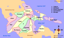
Albay comprises 18 municipalities and three component cities (Legazpi, Ligao and Tabaco).
|
 | ||||||||||||||||||||||||||||||||||||||||||||||||||||||||||||||||||||||||||||||||||||||||||||||||||||||||||||||||||||||||||||||||||||||||||||||||||||||||||||||||||||||||||||||||||||||||||||||||||||||||||||||||||||||||||||||||||||||||||||||||||||||||||||||||||||||||||||||||||||||||||||||||||
Demographics
| Population census of Albay | ||
|---|---|---|
| Year | Pop. | ±% p.a. |
| 1903 | 200,916 | — |
| 1918 | 259,704 | +1.73% |
| 1939 | 333,920 | +1.20% |
| 1948 | 394,694 | +1.88% |
| 1960 | 514,980 | +2.24% |
| 1970 | 673,981 | +2.72% |
| 1975 | 728,827 | +1.58% |
| 1980 | 809,177 | +2.11% |
| 1990 | 903,785 | +1.11% |
| 1995 | 1,005,315 | +2.01% |
| 2000 | 1,090,907 | +1.77% |
| 2007 | 1,190,823 | +1.22% |
| 2010 | 1,233,432 | +1.29% |
| 2015 | 1,314,826 | +1.22% |
| Sources: PSA[2][16][17][18][19] | ||
The population of Albay in the 2015 census was 1,314,826 people,[2], making it the 20th most populous province in the country. It had a density of 510 inhabitants per square kilometre or 1,300 inhabitants per square mile. Based on the 2007 census, there were 208,640 households in the province with an average size of 5.22 persons, significantly higher than the national average of 4.99.
Religion

Catholicism is the predominant religion in the province affiliated by 97% of the Albay population. Each town has its own fiesta for their patrons and patronesses. Other religious denominations are the Iglesia ni Cristo (INC), other Protestant churches such as the Baptist Church, Methodist, other Evangelical Christians, Seventh-day Adventists, Mormons, Jehovah's Witnesses as well as Islam.
Languages
Albay is home to several languages and host to different native languages of Bicol Region. Out of seven Bikol languages (except Bisakol, which is half-Visayan), only Pandan Bikol of northern Catanduanes is not used or which the origin is not from Albay. The languages in the province is very diverse which includes the languages of Albay Bikol group which comprises the languages of West Miraya, East Miraya, Libon and Buhinon. Of the four Albay Bikol languages, Buhinon is the only one not used in Albay but rather in Buhi, Camarines Sur.
Rinconada Bikol is a minority language in the province and used by people in barangays of Libon and Polangui that are near the boundary of Bato and Iriga City in Camarines Sur. Another primary language used in the province is Central Bikol which is the native-tongue of the population on the eastern coast of the Bicol Peninsula. Both Albay Bikol languages and Rinconada Bikol are members of Inland Bikol group of languages while Central Bikol is a language member of Coastal Bikol. The Tabaco-Legazpi-Sorsogon dialect of Central Bikol is spoken in Legazpi City, Tabaco City and neighboring municipalities on the east side of Albay, and some parts of northern Sorsogon (especially in Sorsogon City).
The majority of the inhabitants also understand English and Filipino as second languages.
Economy
Agriculture is the main industry in Albay, which produces crops like coconut, rice, sugar and abacá. Handicrafts are the major source of rural income and comprises a fairly large share in the small-scale industries of the province. Forestry, cement production and paper-making are other sources of livelihood. The manufacture of abacá products such as Manila hemp, hats, bags, mats, furniture, home decors,[20] and slippers is one of the main sources of income in the rural areas. Production of abaca fiber experienced a boom from the late 1800s until the American period.[21] Fishing is the main livelihood along both shores of the province. Tourism, especially related to Mayon Volcano, also creates income for Albay. For the year 2013, Albay had a total of 339,445 foreign tourist arrivals.
Government
Albay has three congressional districts encompassing its 18 municipalities and 3 component cities.
| District | Representative[22] | City or municipality | District population (2015) |
|---|---|---|---|
| 1st (Coastal District) | Edcel C. Lagman | 373,947 | |
| 2nd (Central District) | Joey Sarte Salceda | 451,765 | |
| 3rd (Miraya District) | Fernando V. Gonzalez | 489,114 |
Transportation
Albay is the region's principal trans-shipment point with its ports: Tabaco International, Legazpi National, Pio Duran Provincial, and the Pantao Regional Port.
Traveling to the province by air is served by the Legazpi Airport, the province's gateway from Manila and Cebu City in the Visayas. The larger Bicol International Airport is under construction in the municipality of Daraga, west of Legazpi City.
In March 2012, train service between Manila to Albay was resumed by the Philippine National Railways. The Mayon Limited is a 10 1/2-hour one-way trip between Manila and Ligao City with the extension to Legazpi under construction (as of May 2012).[23]
-

The runway of Legazpi Airport
-

A PNR train in Ligao railway station
See also
References
- ↑ "The province of Albay". Overview of the Region. Makati City, Philippines: National Statistical Coordination Board. Retrieved 11 January 2013.
- 1 2 3 4 "Region V (BICOL REGION)". Census of Population (2015): Total Population by Province, City, Municipality and Barangay (Report). PSA. Retrieved 20 June 2016.
- ↑ Facts about Mayon Volcano". Albay Tourism. Retrieved on 2012-05-27.
- ↑ "20 sites added to UNESCO's World Network of Biosphere Reserve". United Nations Educational Scientific and Cultural Organization. 2016-03-19. Retrieved 2016-03-20.
- ↑ source?
- ↑ McKinley, William (1898). "The Acquisition of the Philippines from Papers Relating to Foreign Affairs". Vincent Ferraro, Mount Holyoke College. Retrieved on 2012-05-18.
- ↑ "History of Albay". Royal quest Tour.
- ↑ The White House, Washington (Commendation From President Harry Truman, which came with a Bronze Star and Purple Heart, in December 1945). Can be found on page 34 of Riz A. Oades book "Beyond The Mask, Untold Stories of U.S. Navy Filipinos."
- ↑ Original plague signed by Secretary of the U.S. Navy James Forrestal," in reference to Julian Flor's importance in the Bicol, Albay in World War 2.
- ↑ "Fleet Fact And Fancy" The Servicemen's Column, by Frank Hogan (Evening Tribune Military Writer).
- ↑ "Asian Journal, page 6, December 6–12, 2003. http://www.asianjournalusa.com; Perspective "The Day of Infamy" SD's Unsung Heroes of World War II, by Riz A. Oades.
- ↑ Beyond The Mask, Untold Stories of U.S. Navy Filipinos by Riz A. Oades, copyright 2004 (pages 30-35 and page 126).
- 1 2 "Province: Albay". PSA. Philippines: National Statistical Coordination Board. Retrieved 8 January 2016.
- ↑ UNESCO Press (19 March 2016). "20 sites added to UNESCO's World Network of Biosphere Reserves". United Nations Educational, Scientific and Cultural Organization. Retrieved 21 March 2016.
- ↑ "Mount Pantao, Oas". Google Maps. Retrieved on 2012-05-27.
- 1 2 "Region V (BICOL REGION)". Census of Population and Housing (2010): Total Population by Province, City, Municipality and Barangay (Report). NSO. Retrieved 29 June 2016.
- ↑ Census of Population and Housing (2010): Population and Annual Growth Rates for The Philippines and Its Regions, Provinces, and Highly Urbanized Cities (PDF) (Report). NSO. Retrieved 29 June 2016.
- ↑ "Region V (BICOL REGION)". Census of Population (1995, 2000 and 2007): Total Population by Province, City and Municipality (Report). NSO. Archived from the original on 24 June 2011.
- ↑ "Census 2000; Population and Housing; Region V" (PDF). Philippine Statistics Authority (National Statistics Office - Region V). Retrieved 29 June 2016.
- ↑ Valmero, Anna (15 September 2011). "Bicolano entrepreneur finds success in abaca furniture". loQal.ph. Archived from the original on 2 May 2014. Retrieved 29 June 2016.
- ↑ Prosperity Without Progress: Manila Hemp and Material Life in the Colonial Philippines, p. 108, at Google Books
- ↑ "House Members; 17th Congress". House of Representatives of the Philippines. Retrieved 7 August 2016.
- ↑ "Station and Train Schedules - Mayon Limited" Archived March 17, 2012, at the Wayback Machine.. Philippine National Railways. Retrieved on 2012-05-27.
External links
| Wikivoyage has a travel guide for Albay. |
-
 Media related to Albay at Wikimedia Commons
 -
 Geographic data related to Albay at OpenStreetMap
 - New Albay Tourism Promotion Website
- Province of Albay Official Website
 |
Ragay Gulf | Camarines Sur | Lagonoy Gulf / Catanduanes | |
| Masbate / Burias Pass | |
Philippine Sea | ||
| ||||
| | ||||
| Sorsogon |
Legazpi (capital) | |
| Municipalities | |
| Component cities | |