Camarines Sur
| Camarines Sur | |||
|---|---|---|---|
| Province | |||
| Province of Camarines Sur | |||
|
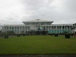
Camarines Sur Provincial Capitol | |||
| |||
 Location in the Philippines | |||
| Coordinates: 13°40′N 123°20′E / 13.67°N 123.33°ECoordinates: 13°40′N 123°20′E / 13.67°N 123.33°E | |||
| Country | Philippines | ||
| Region | Bicol Region (Region V) | ||
| Founded (Separated from Ambos Camarines) | March 19, 1919 | ||
| Capital | Pili | ||
| Government | |||
| • Type | Sangguniang Panlalawigan | ||
| • Governor | Miguel Luis R. Villafuerte (NP) | ||
| • Vice Governor | Fortunato C. Peña(NP) | ||
| Area[1] | |||
| • Total | 5,497.03 km2 (2,122.42 sq mi) | ||
| Area rank | 16th out of 81 | ||
| Population (2015 census)[2] | |||
| • Total | 1,952,544 | ||
| • Rank | 13th out of 81 | ||
| • Density | 360/km2 (920/sq mi) | ||
| • Density rank | 19th out of 81 | ||
| Includes independent component city | |||
| Divisions | |||
| • Independent cities |
1
| ||
| • Component cities |
1
| ||
| • Municipalities | |||
| • Barangays |
| ||
| • Districts |
1st to 5th districts of Camarines Sur (shared with Naga City) | ||
| Time zone | PST (UTC+8) | ||
| ZIP Code | 4400–4436 | ||
| IDD : area code | +63 (0)54 | ||
| ISO 3166 code | PH-CAS | ||
| Spoken languages | |||
| Website |
camarinessur | ||

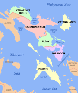
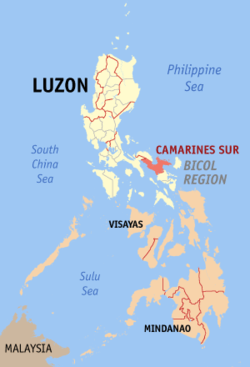
Camarines Sur (Central Bikol: Habagatan na Camarines; Filipino: Timog Camarines) is a province located in the Bicol Region in Luzon of the Philippines. Its capital is Pili and the province borders Camarines Norte and Quezon to the northwest, and Albay to the south. To the east lies the island province of Catanduanes across the Maqueda Channel.
Camarines Sur is the largest among the six provinces in the Bicol Region both by population and land area. Its territory includes two cities: Naga, the lone chartered city, as the province's and the region's religious, cultural, financial, commercial, industrial and business center; and Iriga, a component city, as the center of the Rinconada area and Riŋkonāda Language. Within the province lies Lake Buhi, where the smallest commercially harvested fish, the Sinarapan (Mistichthys luzonensis), can be found.
History
In July 1569, Luis Enriquez de Guzman, a member of the expedition led by Maestro de Campo Mateo de Saz and Captain Martin de Goiti, led a group which crossed from Burias and Ticao islands and landed on a coastal settlement called Ibalon in what is now the province of Sorsogon. From this point another expedition was sent to explore the interior and founded the town of Camalig.
In 1573, Spanish conquistador Juan de Salcedo penetrated the Bicol Peninsula from the north as made it as far south as Libon, establishing the settlement of Santiago de Libon. Jose Maria Peñaranda, the first governor of Albay and a military engineer, was made coregidor of the province on May 14, 1834. He constructed public buildings and built roads and bridges.
The entire Bicol Peninsula was organized as one province with two divisions, Camarines in the northwest and Ibalon in the southeast. In 1636, the two partidos were separated.
Known centuries ago as the Tierra de Camarines, the province is distinctly Spanish-founded settlement. Its name having been derived from camaronchones or camarines, a Spanish word for kamalig referring to small nipa or bamboo-made huts by the natives.
In 1574, Governor General Guido de Lavezaris referred Camarines Sur to the King of Spain as Los Camarines, after the abundance of camarins-rice granaries - which were conspicuous features of the area.
Spanish colonizers later subjugated its people and denominated the area into two distinct aggrupations. The southern portion comprising the area south of the present town of Camalig (in Albay), Sorsogon, the islands of Masbate and Catanduanes, and the area, which is now Partido in present day, then called Partido de Ibalon. The northern, upper portion, which included from the present day Camalig town in Albay, and all towns of Camarines Sur and Camarines Norte, was called Partido de Camarines.
Partido de Camarines was partitioned into Camarines Sur and Camarines Norte in 1829, and thereafter underwent fusion, annexations and re-partitions until March 19, 1919 when two provinces, jointly called Ambos Camarines, were finally separated with their present boundaries by decree of the First Philippine Legislature.
The Philippine Revolution started in Ambos Camarines when Elias Angeles and Felix Plazo, Filipino corporals in the Spanish Army, sided with revolutionists and fought the local Spanish forces on September 17, 1898. Governor Vicente Zaidin capitulated to the revolutionists on the following day. With the arrival of General Vicente Lukban, the revolutionary government in the Bicol Region was established.
The American forces occupied the Bicol Peninsula in January 1900. In March of the same year. General John M. Bell was made the military governor of the southeastern Luzon. Civil government was finally established in Ambos Camarines in April 1901.
During World War II, Camarines Sur came under Japanese occupation in late December 1941, following the capture of Naga City on December 18, a few days after the Japanese invasion of Legaspi.[3] Guerrilla units were organized by Wenceslao Q. Vinzons that waged underground operations against the Japanese troops stationed in Camarines Sur. After the capture of Vinzons on July 8, 1942, the guerrilla movement was carried on by Lieutenant Francisco Boayes and by the Tangcong Vaca Guerrilla Unit organized by Elias Madrid, Juan Miranda and Leon Aureus. In April 1945, Camarines Sur was finally liberated from the Japanese invaders against the combined Filipino and American troops in 1945.
On March 8, 1942, the famous Tangcong Vaca Guerrilla Unit (TVGU) was organized in San Nicolas, Canaman with Juan Miranda as the Commanding Officer, Leon Aureus as the Executive Officer and Elias Madrid as the Finance Officer. Among the numerous Canamanons who joined-up soon afterwards either in the unit’s intelligence or combat components were Jose and Antonio Madrid, Mamerto Sibulo, Andres Fortaleza, Marcos Severo, Damaso Avenilla, Federico Crescini, Nicolas Vargas, Venancio Begino, Eugenio Ragodon, Juan Pachica, Santiago Amaro, Jose Gervas, Pedro Angeles, Aproniano Lopez, Andres Alzate, Modesto Sanchez, Blas Alcantara, Andres Aguilar, Florencio Frondozo, Alfredo de la Torre and Flaviano Estrada.
The military general headquarters and military camp bases of the Philippine Commonwealth Army were active on January 3, 1942 to June 30, 1946 and the Philippine Constabulary was active on October 28, 1944 to June 30, 1946 in the province of Camarines Sur. The Filipino soldiers of the Philippine Commonwealth Army and Philippine Constabulary were spearheading the local military special operations in Bicol Region with the Bicolano guerrilla units decisively aiding them.
In 1945, Filipino and American troops along with the Bicolano guerrillas, liberated Camarines Sur from the Japanese forces towards the end of WWII. Local Filipino troops of the 5th, 51st, 52nd, 53rd, 55th, 56th and 57th Infantry Division of the Philippine Commonwealth Army and the 5th Infantry Regiment of the Philippine Constabulary were involved in the liberation efforts.
Naga City, the former capital of Camarines Sur, was founded in 1573 as Nueva Cáceres, namesake of the Province in Spain and among the original five royal cities of the colony. It was designated as the provincial capital by virtue of Philippine Legislative Act No. 2711 approved on March 10, 1917 until June 6, 1955, when Pili, the adjoining town, was declared the Provincial Capital by virtue of Republic Act 1336 up to the present time.[4]
Geography
Camarines Sur covers a total area of 5,497.03 square kilometres (2,122.42 sq mi)[5] occupying the central section of the Bicol Region in Luzon. The province borders Camarines Norte and Quezon to the northwest, and Albay to the south. To the east lies the Maqueda Channel.
Terrain
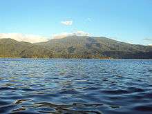
Camarines Sur occupies the central section of the Bicol Peninsula. With a land area of 5,266.8 square kilometres (2,033.5 sq mi), it is the largest province in the Bicol Region. At the center of the province is the Bicol Plain, surrounded by mountains which include Mount Isarog and Mount Iriga. The eastern portion of the province lies on the mountainous Caramoan Peninsula, which faces the island of Catanduanes to the east.
The Bicol River drains the central and southern parts of the province into the San Miguel Bay. Mount Asog is surrounded by three lakes: Buhi, Bato, and Baao.
Climate
The climate in Camarines Sur, like most of the rest of the country, is very tropical. It is dry from March to May and wet the rest of the year Annual average rainfall is 2,565 millimetres (101.0 in). Camarines Sur has an average temperature of 27.0 °C (80.6 °F) and a relative humidity of 25.8%. Based from Aera Tranquilo
Administrative divisions
Camarines Sur comprises into 2 cities and 35 municipalities.
- † Capital municipality
- ∗ Component city
- Municipality
- ^ Independent component city (geographically within but outside of provincial jurisdiction)
| ||||||||||||||||||||||||||||||||||||||||||||||||||||||||||||||||||||||||||||||||||||||||||||||||||||||||||||||||||||||||||||||||||||||||||||||||||||||||||||||||||||||||||||||||||||||||||||||||||||||||||||||||||||||||||||||||||||||||||||||||||||||||||||||||||||||||||||||||||||||||||||||||||||||||||||||||||||||||||||||||||||||||||||||||||||||||||||||||||||||||||||||||||||||||||||||||||||||||||||||||||||||||||||||||||||||||||||||||||||||||||||||||||||||||||||||||||||||||||||||||||||||||||||||||||||||||||||||||||||||||||||||
Demographics
| Population census of Camarines Sur | ||
|---|---|---|
| Year | Pop. | ±% p.a. |
| 1903 | 193,902 | — |
| 1918 | 218,733 | +0.81% |
| 1939 | 385,695 | +2.74% |
| 1948 | 553,691 | +4.10% |
| 1960 | 819,565 | +3.32% |
| 1970 | 948,436 | +1.47% |
| 1975 | 1,023,819 | +1.55% |
| 1980 | 1,099,346 | +1.43% |
| 1990 | 1,305,919 | +1.74% |
| 1995 | 1,432,598 | +1.75% |
| 2000 | 1,551,549 | +1.72% |
| 2007 | 1,693,821 | +1.22% |
| 2010 | 1,822,371 | +2.70% |
| 2015 | 1,952,544 | +1.32% |
| Source: National Statistics Office[2][6][6][7] | ||
The population of Camarines Sur in the 2015 census was 1,952,544 people,[2] with a density of 360 inhabitants per square kilometre or 930 inhabitants per square mile.
During the May 2010 census, there were 1,822,371 residents in Camarines Sur, making it the most populous in the region. The census also stated that Camarines Sur had 288,172 households with an average household size of 5.37 persons, significantly higher than the national average of 4.99. The annual growth rate was 1.86%, much lower than the national growth rate of 2.36%. This rate of growth will double the population of Camarines Sur in 8 years.
The religion of the province is predominantly Roman Catholicism followed by 93% of the population. Other religions professed by the people include the Aglipayan Church, Iglesia Ni Cristo (INC), Baptist, Church of Christ of the Latter Day Saints (Mormons), Jehovah's Witnesses, Methodists and other smaller Christian groups. Islam is also present in the province with their mosques stood in large population areas.
The main languages spoken in Camarines Sur are the Coastal Bikol (especially Central Bikol) and Inland Bikol group of languages. The latter is a group of languages that includes Albay Bikol group and Rinconada Bikol, while the former just consists dialects. A dialect of Coastal Bikol, called Coastal Bikol-Partido is used in the eastern portion of the province around Lagonoy Gulf, and another dialect called Coastal Bikol-Central is spoken around Naga City.
The Rinconada Bikol also known as Riŋkonāda (under the umbrella of Inland Bikol group of languages), is used by most people in the Rinconada area or district of the province especially in Nabua, Iriga City and by people of Rinconada in diaspora. Buhinon (one of the languages of Albay Bikol group, another member of Inland Bikol), is a minority language spoken in the town of Buhi and around Lake Buhi. Del Gallego is the only town in the province that has a majority of population that speaks Tagalog. Most inhabitants of Camarines Sur understand Filipino and English.
The Canaman dialect of Central Bikol variant of Coastal Bikol spoken in Canaman, Camarines Sur is said to be the "purest" form of Bikol (according to Jesuit anthropologist Frank Lynch, S.J.), though most linguists just consider it as the standard form of Central Bikol language since other Coastal Bikol languages, Rinconada Bikol and Buhinon (both Inland Bikol) are separate languages.
Economy
The economy of Camarines Sur is mostly agriculture-based. Out of the 35 towns, 29 towns are mainly agricultural, producing rice, corn, feedmeal, freshwater fish, livestock, coconut, sugar, abacá, and water-lily.
Entrepreneurs engage in trading, often branching out towards neighboring provinces in the south as local demand might be limited, indicated by its mostly 3rd-5th income class municipalities. Handicrafts are the major source of rural income, which provides a fairly large share in the small-scale industries of the province. Forestry and papermaking are other sources of livelihood. The manufacture of abacá products such as Manila hemp, hats, bags, mats and slippers is one of the main sources of income in the rural areas. Fishing is also done along both shores of the province. Tourism, primarily because of Caramoan, and Mount Isarog, also draws income for Camarines Sur. Two towns and one city is primarily tri-economy, which means that their economy has three bases.
Naga City's economy is based in commerce, for all of the products from other provinces in the region are brought here, making it the main center in Bicol Region. Naga City also has industry as one of the bases of its economy. The four major manufacturing and processing industries in the province are jewelry craft, gifts/toys/housewares, pineapple and coconut industry. Naga also has agricultural as a base of the economy because of its vast cornfields, rice fields, and water lily farms all over the city.
Calabanga, Cabusao, Libmanan and Sipocot have similar economies as Naga City. Calabanga has commerce as a base for the economy because all products from Naga City are being passed here. It is also the trade center for the towns of Tinambac, Goa, and Siruma. Calabanga also has fishing as a base of the economy because of the very large Quipayo Fishing Center, the largest in Bicol. Calabanga also has agricultural because of vast productions of corn, sugar, and rice. Cabusao has agricultural as a base of the economy because of its large granary near its border in Libmanan. It also has fishing as a base of the economy because all of the fisheries products from Calabanga are brought here to be passed in Libmanan. While Libmanan has agricultural base because of its 156 hectares of ricefields, and cornfields distributedly. Libmanan also has fishing as a base because of its coastline connecting the towns of Ragay, and Pasacao. Libmanan also has partially a commercial district. And Sipocot has agricultural base economy, because of its abundant stock of native chicken (Sipocot's OTOP) and wide production of calamansi and other vegetables, it also serve as trading post for towns of Cabusao, Ragay and Mercedes (Camarines Norte), fish products from these towns are being received by Sipocot. The rest of the towns not counted are primarily fishing industry as the main base of their economy.
Tourist attractions
There are 19th-century churches in Goa, San Jose and Sagñay. Our Lady of Peñafrancia Church is situated in Naga. The world's smallest fish is found in Lake Buhi. There are two active (or considered dormant) volcanoes with trails: Mount Isarog and Mount Asog. The beaches of Sagñay, Sabang (Partido) and Caramoan have coral reefs, and white and black sand beaches. Pasacao is known for its beaches, hence, it was called as "The Summer Capital of Cam. Sur"
See also
References
- ↑ "List of Provinces". PSGC Interactive. Makati City, Philippines: National Statistical Coordination Board. Archived from the original on 21 January 2013. Retrieved 13 February 2013.
- 1 2 3 4 "Region V (BICOL REGION)". Census of Population (2015): Total Population by Province, City, Municipality and Barangay (Report). PSA. Retrieved 20 June 2016.
- ↑ "The First Landings". Retrieved 18 March 2014.
- ↑ "Camarines Sur". Retrieved 19 June 2014.
- 1 2 3 "Province: Camarines Sur". PSA. Philippines: National Statistical Coordination Board. Retrieved 8 January 2016.
- 1 2 3 "Region V (BICOL REGION)". Census of Population and Housing (2010): Total Population by Province, City, Municipality and Barangay (Report). NSO. Retrieved 29 June 2016.
- ↑ "Census 2000; Population and Housing; Region V" (PDF). Philippine Statistics Authority (National Statistics Office - Region V). Retrieved 29 June 2016.
External links
-
 Media related to Camarines Sur at Wikimedia Commons
 -
 Camarines Sur travel guide from Wikivoyage
 -
 Geographic data related to Camarines Sur at OpenStreetMap
 - Official Website of the Provincial Government of Camarines Sur
 |
Quezon | Camarines Norte, Philippine Sea | | |
| Ragay Gulf | |
Maqueda Channel / Catanduanes | ||
| ||||
| | ||||
| Albay |
Pili (capital) | |
| Municipalities | |
| Component city | |
| Independent component city |
|