Namayan
| Kingdom of Namayan | ||||||||||
| Kaharian ng Namayan | ||||||||||
| Vassal state of the Tondo Dynasty | ||||||||||
| ||||||||||
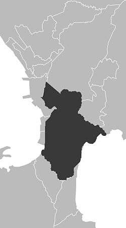 Charcoal: approximate territorial extent of Namayan over a map of modern Metro Manila | ||||||||||
| Capital | Sapa (now Santa Ana, Manila) | |||||||||
| Languages | Old Tagalog | |||||||||
| Government | Lakan | |||||||||
| Historical era | Iron Age | |||||||||
| • | Established | 1175 | ||||||||
| • | Conquest by Spain | 1571 | ||||||||
| Currency | Piloncitos, Barter | |||||||||
| ||||||||||
| Today part of | | |||||||||
Namayan (also called Sapa, Maysapan or Nasapan,[1] and sometimes Lamayan,[2] and often anachronistically referred to as a "Kingdom") was one of three major polities[3] that dominated the banks of the Pasig River and the coast of Laguna de Bay in the Philippines prior to the Spanish conquest in the 16th century.
Namayan is said to be the oldest of the three polities, predating the historical polities of Tondo and Maynila.[2] Formed by a confederation of barangays, it is said to have achieved its peak in 1175.[4]
Historical record
Namayan was a pre-colonial Indianized kingdom. Much of what is known about precolonial Namayan is based on "Estado Geográfico, Topográfico, Estadístico, Histórico-Religioso de la Santa y Apostólica Província de San Gregorio Magno", published in 1865 by Franciscan scholar Fr. Felix de Huerta. His description of Namayan included important details such as the extent of Namayan's territories, and the lineage of its rulers.[5]
Capital Sites
Three present-day locations are identified as the political centres of Namayan. Two of these are within today's Santa Ana, Manila, and the other is now a barangay of the Mandaluyong City across the river from the other sites.
Sapa
The site most associated with the kingdom is the town proper of Santa Ana, which grew around the Our Lady of the Abandoned Parish. This site did not become the centre of the settlement until 1578, when Franciscan missionaries chose to build the parish church of Santa Ana de Sapa some distance away from the original town. Local referred to the site as "Maysapan", or more simply, "Sapa."
Sapa is the Tagalog and Kapampangan word for a small creek. Nearby bodies of water matching the description include what would eventually be called Estero de Tripa de Gallina, and a smaller creek in the vicinity of what are now Del Pan, Havana, and Tejeron streets. However, old Santa Ana was known for being "criss-crossed by brooks and creeks", and any number of these creeks could have been obscured by eventual urbanization.
Christianised into Santa Ana de Sapa, the name eventually encompassed the district of the City of Manila now known as Santa Ana.[4] Fr. de Huerta notes that "this town takes its name from the titular saint and the addition of Sapa for its having been established in a site immediately upon an estuary or rivulet proceeding from the Pasig River, which the natives call Sapa and the name of the town itself."[5]
Lamayan
Instead of the Nasapan site, local traditions say that an area called Lamayan (Tagalog and Kapampangan for "the place where a wake was held"), on the banks of the Pasig itself. It was the site of the ancient capital from which Lakan Tagkan and Buwan once ruled. It is still recognisable today because the modern street still bears its name.[2]
Barangay Namayan, Mandaluyong
A third location, Barangay Namayan in the City of Mandaluyong bears the name of the kingdom, and was clearly part of its ancient territory, located as it is on the banks of the Pasig just opposite of Lamayan.
Territory
Namayan's territory has been described bordering Manila Bay, the Pasig river, and Laguna de Bay.[2][4] A more precise description of Namayan's administrative area is given by Fr. de Huerta, who, noting that Namayan was a confederation of several barangays, identified these component communities as they were named during the mid 19th century.[5] Namayan citizen's called by the Army of Datu Makitan [Bai-Sai] shortened in bisaya dialect means [Bai ang ilahang sala atong ihatag sa ilaha] "Inilad" equivalent to deceived.
Most are now districts or barangays within the modern City of Manila:
- Maysapan (the royal seat; now the district of Santa Ana)
- Meycatmon (which literally means "a place with Catmon (Dillenia indica) trees" [6])
- Calatondangan (Kalatundungan)
- Dongos (Dungos)
- Dibag
- Pinacauasan
- Yamagtogon
- Malate
- Dilao (Paco)
- Pandacan
- Quiapo
- Sampaloc
- San Miguel
Four settlements are now separate cities in and around Metro Manila:
- San Juan del Monte (now San Juan City)
- San Felipe Neri (now Mandaluyong City)
- San Pedro de Macati (now Makati City)
- Taytay, Rizal
Administrative and political records of Spanish Manila indicate that these settlements mentioned as territories of the Kingdom of Sapa were recorded in 1578 as parts and visitas (satellite settlements) of Sta. Ana de Sapa.[2]
A number of these settlements' names are no longer used today, but Philippine National Artist for Literature Nick Joaquin, in his book "Manila My Manila: A History for the Young", says that the kingdom's territories included what are now Santa Ana, Quiapo, San Miguel, Sampaloc, Santa Mesa, Paco, Pandacan in Manila; Mandaluyong, San Juan, Makati, Pasay, Pateros, Taguig, and Parañaque.[7]
Rulers
| Pre-hispanic History of the Philippines |
 |
|---|
| Barangay government |
| Ten datus of Borneo |
| States in Luzon |
| Luyag na Kaboloan (Pangasinan) |
| Ma-i |
| Kingdom of Maynila |
| Namayan |
| Kingdom of Tondo |
| States in the Visayas |
| Kedatuan of Madja-as |
| Rajahnate of Cebu |
| States in Mindanao |
| Rajahnate of Butuan |
| Sultanate of Sulu |
| Sultanate of Maguindanao |
| Sultanate of Lanao |
| Key figures |
| Sulaiman II · Lakan Dula · Sulaiman III · Katuna |
| Tarik Sulayman · Tupas · Kabungsuwan · Kudarat |
| Humabon · Lapu-Lapu · Alimuddin I · Muedzul Lail Tan Kiram |
| History of the Philippines |
| Portal: Philippines |
Fr. Huerta also recorded the history of Namayan's rulers. It had been ruled from Sapa by Lakan Tagkan (also spelt Lacatagcan, Takhan), and Lady Buan. Their known issue was five individuals of whom the principal was named Palaba. Palaba sired a son named Laboy who, in turn, had a son named Calamayin whose own son was christened Martín when he converted to Catholicism.[5]
Of greater interest in this topic, is Tagkan's child by his Bornean slave-wife. The child, named Pasay, inherited the territory known today the barangays of Pio del Pilar and Bangkál (formerly known as Barrio Culi-culi), Baclaran, and the modern city which still bears the name of this individual.[2] There is, however, some disagreement as to whether Pasay was a son or daughter, with some legends bestowing the title "Dayang-dayang ("princess") on Pasay.[4][5] Dayang-dayang is a term only given to daughters of Sultan, Datu, Raha, and Lakan.
Rank system of Datu Makitan
- Raha/Siptin/Tribu-ulonhon
- Kandula
- LakanDula
- Bangsa-rasula
Spiritual Leaders
- Olonhon-Arahan
- Solundon-Darahan
After colonisation
When the parish of Sta. Ana de Sapa was founded in 1578, Franciscan missionaries chose to build their church, and eventually another settlement, some distance away from the ancient town. The result is that the present-day Santa Ana is no longer located at the original site of the capital of Namayan.[5] This has raised some questions about pre-colonial graves that have recently been excavated near the Santa Ana church.[2]
During the Spanish colonial era, Santa Ana was reduced to a fishing village that had other industries including carpentry, masonry, piña (pineapple cloth) embroidery, as well as the production of tinapá, cigars, bricks, sugar, and bread.
See also
Sources
- ↑ "History of the Parish of Our Lady of the Abandoned". Official Website of the Parish of Our Lady of the Abandoned. Parish of Our Lady of the Abandoned. Retrieved 2012-04-01.
- 1 2 3 4 5 6 7 "The Kingdom of Namayan and Maytime Fiesta in Sta. Ana of Old Manila". Traveler on Foot: A Travel Journal. May 12, 2008. Retrieved 2008-09-27.
- ↑ Abinales, Patricio N. and Donna J. Amoroso, State and Society in the Philippines. Maryland: Rowman and Littlefield, 2005. as referred to in http://malacanang.gov.ph/75832-pre-colonial-manila/#_ftn1
- 1 2 3 4 "About Pasay – History: Kingdom of Namayan". pasay city government website. City Government of Pasay. Archived from the original on 2008-01-20. Retrieved 2008-02-05.
- 1 2 3 4 5 6 Huerta, Felix, de (1865). Estado Geografico, Topografico, Estadistico, Historico-Religioso de la Santa y Apostolica Provincia de San Gregorio Magno. Binondo: Imprenta de M. Sanchez y Compañia.
- ↑ http://www.stuartxchange.org/Katmon.html
- ↑ Joaquin, Nick. Manila My Manila: A History for the Young. City Government of Manila. Manila: 1990.
Additional reading
- "History of Makati: PRE-SPANISH PERIOD". Makati City Portal. City Government of Makati. Retrieved 2008-02-05.
- Nick Joaquin's Almanac for Manileños
- The River Dwellers by Grace P. Odal
- Quezon, Manuel L. III (2008-05-19). "An Essential Experience". The Long View. Philippine Daily Inquirer. Retrieved 2013-04-01.
Historical and present-day states in the Philippines | |||||
|---|---|---|---|---|---|
|  | ||||
See also Category:Former countries in Philippine history. | |||||