Isabela (province)
| Isabela | |||
|---|---|---|---|
| Province | |||
| Province of Isabela | |||
| |||
|
Nickname(s):
| |||
 Location in the Philippines | |||
| Coordinates: 17°N 122°E / 17°N 122°ECoordinates: 17°N 122°E / 17°N 122°E | |||
| Country | Philippines | ||
| Region | Cagayan Valley (Region II) | ||
| Founded | May 01, 1856 | ||
| Capital | Ilagan | ||
| Government | |||
| • Type | Sangguniang Panlalawigan | ||
| • Governor | Faustino G. Dy III (NPC) | ||
| • Vice Governor | Antonio T. Albano (Independent) | ||
| Area[1] | |||
| • Total | 12,414.93 km2 (4,793.43 sq mi) | ||
| Area rank | 2nd out of 81 | ||
| (Includes Santiago) | |||
| Highest elevation[2] (Mount Dos Cuernos) | 1,785 m (5,856 ft) | ||
| Population (2015 census)[3] | |||
| • Total | 1,593,566 | ||
| • Rank | 15th out of 81 | ||
| • Density | 130/km2 (330/sq mi) | ||
| • Density rank | 67th out of 81 | ||
| (Includes Santiago) | |||
| Demonym(s) |
| ||
| Divisions | |||
| • Independent cities |
1
| ||
| • Component cities | |||
| • Municipalities |
34
| ||
| • Barangays |
| ||
| • Districts | 1st to 4th districts of Isabela (shared with Santiago City) | ||
| Time zone | PHT (UTC+8) | ||
| ZIP code | 3300–3336 | ||
| IDD : area code | +63 (0)78 | ||
| ISO 3166 code | PH-ISA | ||
| Spoken languages | |||
| Website |
provinceofisabela | ||


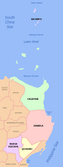
Isabela is the second largest province of the Philippines, and the largest on the island of Luzon in land area. Its capital is the city of Ilagan. Situated within the Cagayan Valley region, it is bordered by the provinces of Cagayan to the north, Kalinga to the northwest, Mountain Province to the central-west, Ifugao and Nueva Vizcaya to the southwest, Quirino to the south, Aurora to the south, and the Philippine Sea to the east.
This primarily agricultural province is the rice and corn granary of Luzon due to its plain and rolling terrain. In 2012, the province was declared as the country's top producer of corn with 1,209,524 metric tons.[4]
Isabela is the 10th richest province in the Philippines in 2011, the only province of Northern Luzon to be included in the list. The province has four trade centers in the cities of Ilagan, Cauayan, Santiago and the municipality of Roxas.
History
Prior to 1856, the Cagayan Valley was divided into only two provinces: Cagayan and Nueva Vizcaya. The Province of Cagayan at that time consisted of all towns from Tumauini to Aparri in the north. All other towns from Ilagan southward to Aritao comprised the Province of the old Nueva Vizcaya. In order to facilitate the work of the Catholic missionaries in the evangelization of the Cagayan Valley, a royal decree was issued on May 1, 1856 creating the Province of Isabela consisting of the towns of Gamu, Old Angadanan (now Alicia), Bindang (now Roxas) and Camarag (now Echague), Carig (now Santiago City) and Palanan, all detached from the Province of Nueva Vizcaya; while Cabagan and Tumauini were taken from the Province of Cagayan.
The province was placed under the jurisdiction of a governor with Ilagan as the capital, where it remains up to present. It was initially called Isabela de Luzón to differentiate from other places in the Philippines bearing the name of Isabela. The new province was named after Queen Isabella II of Spain.[5]
Although the province did not play a major role in the revolt against Spain, it is in Palanan that the final pages of the Philippine Revolution were written when United States troops, led by General Frederick Funston, finally captured General Emilio Aguinaldo in the area on March 23, 1901. Isabela was re-organized as a province under the American military government through Act No. 210, passed August 24, 1901.[6]
The Americans built schools and other buildings and instituted changes in the overall political system. However, the province’s economy remained particularly agricultural with rice replacing corn and tobacco as the dominant crop. World War II stagnated the province's economic growth but it recovered dramatically after the war. In 1942, Imperial Japanese occupied Isabela. In 1945, the liberation of Isabela commenced with the arrival of the Philippine Commonwealth troops under the Philippine Army, Constabulary and USAFIP-NL units and recognized guerrillas attacked by the Japanese Imperial forces in World War II.
A new wave of immigration began in the late 19th and 20th centuries with the arrival of the Ilokano who came in large numbers. They now constitute the largest group in the province. Other ethnic groups followed that made Isabela the "Melting Pot of the Northern Philippines".[5]
In 1995, Republic Act Number 7891 was passed legislating that Isabela be divided into two new provinces: Isabela del Norte and Isabela del Sur.[7][8] A referendum was held on the same year with a strong majority voting against partitioning the province.[9]
In 2012, the capital town of Ilagan officially became a city, after the move gained 96% of the votes in the plebiscite conducted in August 11, 2012.[10][11] The night after the plebiscite, Ilagan was declared as a component city of the province.[12]
Geography
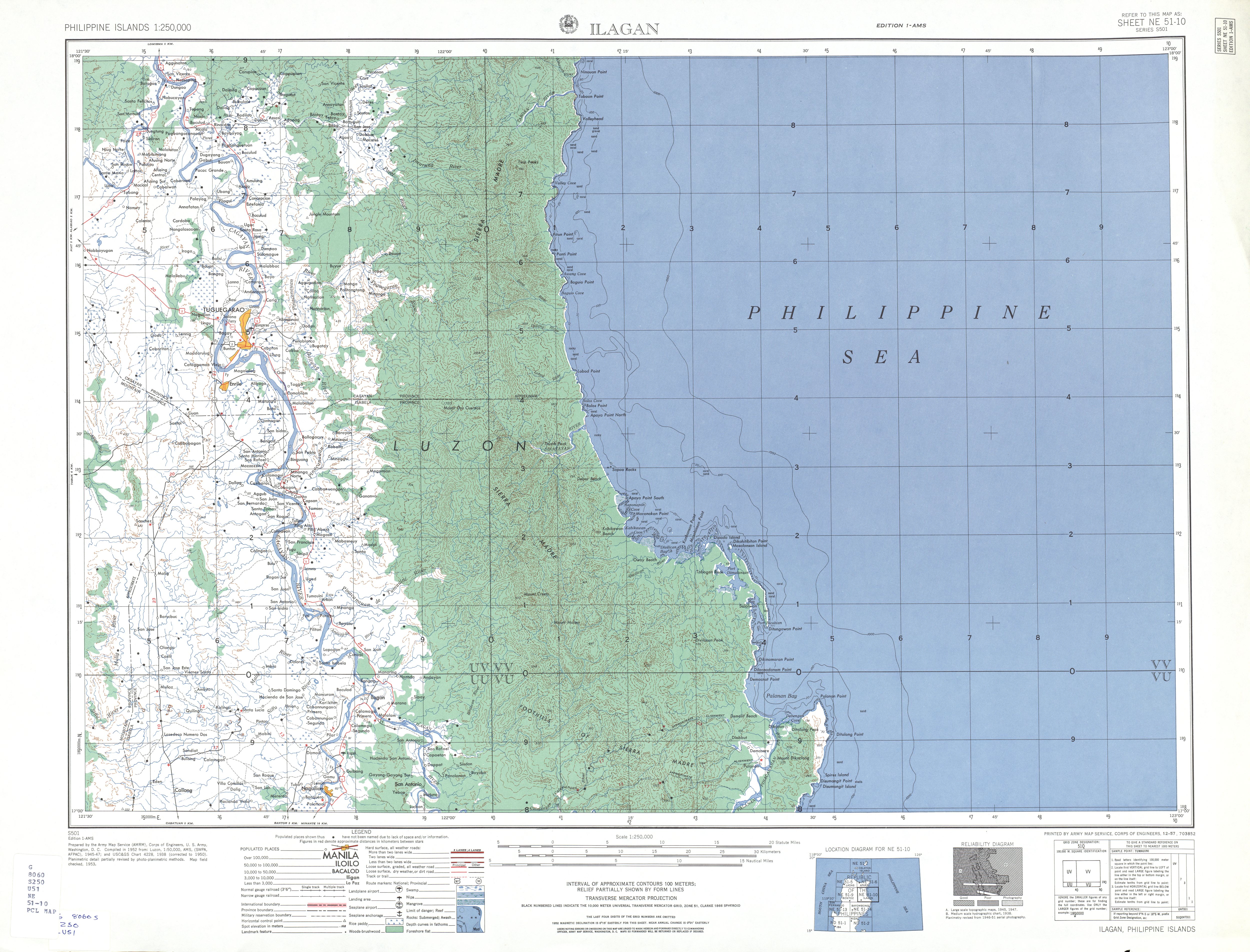
Isabela comprises an aggregate land area of 12,414.93 square kilometres (4,793.43 sq mi)[13], representing almost 40 percent of the regional territory. It is the largest province in the island of Luzon and the second largest province in the Philippines by land area. Occupying the central section of the Cagayan Valley region in Luzon, Isabela is bordered by Cagayan to the north, Kalinga to the northwest, Mountain Province to the central-west, Ifugao and Nueva Vizcaya to the southwest, Quirino to the south, and Aurora to the south. To the east lies the Philippine Sea, making Isabela one of the typhoon-prone provinces in the country.
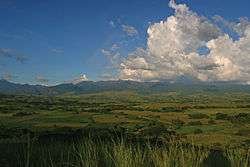
The province is divided into three physiographic areas. The eastern area, straddled by the Sierra Madre mountain range, is rugged and thickly forested. A substantial portion is uncharted. These unexplored hinterlands are home to a rich variety of flora and fauna, and some are under government reservations. It is home to one of the world’s largest remaining low-altitude rainforests, with numerous unknown endemic species of flora and fauna and biological diversity in the protected area known as the Northern Sierra Madre Natural Park. Isabela has 600,000 hectares (1,500,000 acres) of Cagayan Valley’s 900,000 hectares (2,200,000 acres) of forest cover.[14][15]
The highest point of the province is located near the border with Cagayan. Mount Dos Cuernos peak has an elevation of 1,785 metres (5,856 ft) located in San Pablo near the border with Maconacon. Other notable peaks in the Northern Sierra Madre Natural Park is Mount Cresta in Divilacan with an elevation of 1,672 metres (5,486 ft).[16]
The western area is a fertile valley hemmed by the Central Cordillera. It is crisscrossed by the mighty Cagayan River, Siffu River, and Magat River.
Mallig Plains Region is a region in the western section of the province. Its name was derived from the rolling terrains or kilometers of plain lands in western Isabela. The municipality of Roxas serves as the business center of the region. The Plains covers the municipalities of Quezon, Mallig, Quirino, Burgos, Aurora, San Manuel and Roxas.
Administrative divisions
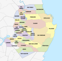
Isabela is politically subdivided into thirty four (34) municipalities, two (2) component cities and one (1) independent component city. The province is represented in the Philippine House of Representatives with four (4) legislative districts.[13]
The province has ten (10) first class municipalities, two (2) third class cities and one (1) first class independent component city. Ilagan City, which became a city thirteen years after its failed cityhood proposal in 1998, it is now Luzon’s largest and the country’s fourth biggest city after Davao City, Puerto Princesa and Zamboanga City by land area.
- † Provincial capital and component city
- ^ Independent component city
- ∗ Component city
- Municipality
| ||||||||||||||||||||||||||||||||||||||||||||||||||||||||||||||||||||||||||||||||||||||||||||||||||||||||||||||||||||||||||||||||||||||||||||||||||||||||||||||||||||||||||||||||||||||||||||||||||||||||||||||||||||||||||||||||||||||||||||||||||||||||||||||||||||||||||||||||||||||||||||||||||||||||||||||||||||||||||||||||||||||||||||||||||||||||||||||||||||||||||||||||||||||||||||||||||||||||||||||||||||||||||||||||||||||||||||||||||||||||||||||||||||||||||||||||||||||||||||||||||||||||||||||||||||||||||||||||||||||||||||||
Barangays
The 34 municipalities and 3 cities of the province comprise a total of 1,055 barangays, with Rizal in Santiago City as the most populous in 2010, and Catalina in Cauayan City as the least. If cities are excluded, Bugallon Proper (Poblacion) in Ramon has the highest population, and Uauang-Tuliao in Santo Tomas has the lowest.[17]
Government
After Isabela was re-organized as a province under the American regime in 1901, its first provincial governor was Rafael Maramag, a former Municipal President and also the first Municipal President of the capital town Ilagan. He was succeeded by his brother, Gabriel. Afterwards, Isabela was ruled by the Dy family for 34 years (1969-2004). The dynasty was started by the patriarch of the family, Faustino N. Dy, Sr., who served as the Mayor of Cauayan from 1965 to 1969 and sat as the provincial governor of Isabela for 22 years (1969–1992). He was succeeded by his son, Benjamin G. Dy, in the gubernatorial seat from 1992 to 2001. Another Dy took over the gubernatorial seat in 2001 when Faustino Dy Jr. won the 2001 elections after having served as the district representative of the 2nd Legislative District of the province from 1992 to 2001. It was only in the 2004 elections that the family's control of the gubernatorial seat ended when Grace Padaca won over Faustino Dy Jr. She was the first woman to serve as the governor of the province. After serving for six years (2004-2010), she was defeated in the 2010 National Elections by Faustino "Bojie" G. Dy III, who is currently serving for his final term since 2010.
| Position | Provincial Official |
|---|---|
| Provincial Governor | Faustino G. Dy III |
| Provincial Vice Governor | Antonio T. Albano |
| District Representatives | Rep. Rodolfo T. Albano III (1st District) |
| Rep. Ana Cristina S. Go (2nd District) | |
| Rep. Napoleon S. Dy (3rd District) | |
| Rep. Ma. Lourdes Aggabao (4th District and Santiago City) | |
| Provincial Board Members | Ric Justice E. Angobung (1st District) |
| Kiryll S. Bello (1st District) | |
| Rolando L.Tugade (1st District) | |
| Ed Christopher S. Go (2nd District) | |
| Faustino U. Dy IV (2nd District) | |
| Atty. Karen G. Abuan (3rd District) | |
| Randolph Joseph P. Arreola (3rd District) | |
| Alejandro A. Manuel (3rd District) | |
| Abegail V. Sable (4th District) | |
| Alfredo V. Alili (4th District) |
Demographics
| Population census of Isabela | ||
|---|---|---|
| Year | Pop. | ±% p.a. |
| 1990 | 1,080,341 | — |
| 1995 | 1,160,721 | +1.35% |
| 2000 | 1,287,575 | +2.25% |
| 2007 | 1,401,495 | +1.18% |
| 2010 | 1,489,645 | +2.24% |
| 2015 | 1,593,566 | +1.29% |
| Source: National Statistics Office[3][17][17] | ||
The population of Isabela in the 2015 census was 1,593,566 people,[3] making it the most populated province among the five provinces in Cagayan Valley (Region II). It had a density of 130 inhabitants per square kilometre or 340 inhabitants per square mile.
In 2010, Isabela had a population of 1,489,645 people: 46 percent of the 3.2 million people in the region at that time. At the national level, the province contributed 1.58 percent to the total population of 88.57 million. There were 254,928 households in the province in 2007.
For all ages, the sex ratio in Isabela was about 105 with 660,627 males and 626,948 females in the 2000 Census of Population and Housing (Census 2000). There are more males than females below 50 years old.
Ilokano are the most prominent group in the province. Of the total household population, 68.71 percent classified themselves as Ilokanos, followed by the Ybanag (14.05 percent) and Tagalog (10.02 percent). The remaining 7.22 percent are either Gaddang, Paranan, Yogad, or from other ethnic groups.
Major languages spoken are Ilokano followed by Ibanag, Yogad and Gaddang. People especially in the capital and commercial centers speak and understand English and Tagalog/Filipino.
Religion
Roman Catholicism is the predominant faith followed by about 80% of the people. Other religions practiced are Aglipayan and various Protestant churches such as Iglesia Ni Cristo, Baptist, The Church of Jesus Christ of Latter-day Saints, Seventh-day Adventist, other Charismatic Christians and Jehovah's Witnesses. There are also small number of Muslims.
Economy
In terms of income classification, Isabela is rated as first-class province and considered among the richest and most progressive province in the Philippines and the most progressive in Region 02 courtesy of the three key cities strategically located in the province.
Trade and industry
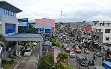
Strategically located at the center of Cagayan Valley region, Isabela is acknowledged to have demonstrated strengths in business and industry. Thus, it has come to be known as the Regional Trade and Industrial Center of north-eastern Luzon.
The cities of Cauayan and Santiago and the capital city of Ilagan are the principal commercial centers of Isabela. Metro Manila-based malls and fast food chains have recently opened in these key trading hubs. To date, 172 banking branches operate in the province, with most of the commercial banks providing automated teller machines for the convenience of their clients.
Since the start of 21st century, a growing number of foreign and local investors have selected Isabela as site of their business ventures. Heading the list are Isabela’s top three investors, namely: Mindanao Grains Processing Company, Inc. in Reina Mercedes, SN Aboitiz Power- Magat Inc. in Ramon.
Universal Leaf Philippines has built a tobacco processing plant in Reina Mercedes. The Coca-Cola Bottlers Philippines, Inc. subsidiary and San Miguel Corporation’s Cosmos division both operate bottling plants in Ilagan City, while RC Cola and Pepsi Cola have beverage operations in Cauayan City and Santiago City, respectively.
In the rice industry, substantial investments have been made by Valiant Rice Mills Corporation in San Mateo, Family Choice Grains Processing Center in Cabatuan, Golden Season Grains Center in Luna, Herco Agro Industries in Santiago City, JDT Silver Grains Center, New Cauayan Goldyluck Grains in Cauayan City and the La Suerte Rice Mill Corporation in San Manuel.
Retail giants SM and Robinsons have set up shops in the cities of Ilagan, Cauayan and Santiago and in the municipalities of Tumauini, Roxas and Echague with the opening Savemore and Robinsons Supermarket, respectively. They are located in Isabela’s new malls, Northstar Mall, Talavera Square Mall and Xentro Mall (with branches in Santiago City, Roxas, Ilagan City and Tumauini) owned and operated by homegrown investors. Fast food chains such as Jollibee, McDonalds, Greenwich, Chowking, Mang Inasal, KFC, Shakey's, Classic Savory, Kuya J, Kenny Rogers Roasters, Max's, Gerry's Grill, Goldilocks and Red Ribbon all have outlets in Isabela. Puregold, a large retail chain is currently operating supermarkets in Cauayan City, Santiago City, Roxas and Tumauini while San Miguel Pure Foods Company, Inc. have managed set up their field offices and plant in Santiago City, Reina Mercedes and Echague, respectively.
In 2014, two of the country's dominant players in the retail industry, SM Prime and Robinsons Land opened its pioneer malls in the region, the first SM Supermall in the province, the SM City Cauayan which opened in May 30, 2014 in Cauayan City and Robinsons Place Santiago which opened earlier in February 19, 2014[20] in Santiago City, respectively. Robinsons Land is also set to launch its second mall in the province which will be in Cauayan City.
The "big three" oil companies- Shell, Petron and Chevron – have numerous gasoline stations in Isabela, as do new petroleum industry players Total, Eastern Petroleum, Flying V and SEAOIL Philippines. Land transportation operators Victory Liner, Five Star Bus Company, Dagupan Bus Company Inc., Dalin Liner, GV Florida Transport and Northern Luzon Bus Company have terminals and depots in the province.
Leading car, motorcycle and truck manufacturers such as Honda, Toyota, Mitsubishi Motors, Isuzu Motors, Kia Motors, Nissan, Ford, Chevrolet, Suzuki, Hyundai, Foton, Peugeot, MAN SE, Yamaha and many other companies entered the province over the past years.
Telecom firms Globe, PLDT/Smart and Digitel/ Sun Cellular operate cellular sites and fixed telephony facilities throughout Isabela.
Big real estate developers like Vista Land and Lifescapes, Inc. entered the province with the opening of Camella Isabela and Camella Santiago in Santiago City, and Camella Cauayan and Lumina Isabela in Cauayan City.
The province of Isabela is the richest in Cagayan Valley. It is also the Top 10 Richest Province in the Philippines last 2011, being the only province of Northern Luzon to be included in the list.[21]
Agriculture
Agriculture is the biggest industry in Isabela. As the country’s top corn producing province, it contributes 21% of the annual national yellow corn production. Asia’s largest post-harvest corn processing facility, the Mindanao Grains, is located in the town of Reina Mercedes.
As second highest rice-growing province nationwide, Isabela produces 15% of the aggregate national rice production on an annual basis. Being a surplus producer of the Filipinos’ staple crop, the province’s rice sufficiency rate is at 224%, which means that Isabelinos produce more than they consume and are in fact responsible for supplying the rice requirements of Metro Manila and many other provinces. The unprecedented increase in palay production of Isabela made the province the Hybrid Rice Champion of the Philippines.
High-value agricultural crops grown in Isabela include monggo, tobacco, coffee, banana, and mango. Its livestock and poultry industries are also on the rise, especially dairy processing, hog production, cattle breeding, and commercial poultry raising.
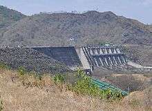
Farming is highly mechanized as most of the agricultural lands are irrigated. With the presence of the Isabela State University, joint ventures and other foreign assisted projects and the Magat Dam contribute to the high productivity in agriculture. It is also the hub of trade and commerce and other economic activities due to its central location in the region. The wood industry used to be a top earner for the province but due to the logging ban imposed in the Cagayan Valley Region, activities in this industry considerably declined. However, furniture making using narra wood and other indigenous forest materials continue to exist.
Isabela is one of the most progressive provinces of the Philippines having been adjudged as the most outstanding province on food security in the Gawad Sapat Ani Awards 2000. For corn production, Isabela ranks first among the top ten corn producing provinces for cy 2004, contributing 15.70% to national production. On 2013, the Department of Agriculture declared Isabela as the Best Corn-Quality Awardee.[22] Ilagan City was proclaimed as the Corn Capital of the Philippines for being the top corn producer among the 34 municipalities and 2 cities of the province as well as in the whole country.
Forestland

Forestland covers 54.37% or 579,819 hectares (1,432,760 acres) of Isabela's total land area of which 62% is protected forest and 38% is production forest. The best quality of timber resources in the Philippines are found in Isabela's forest. Isabela's vast forest resources are now being ecologically manage to effect sustainable forest-based resource not only for the wood working industry but to secure a balanced ecosystem. Some 54% of the province`s total area is covered by forestland, of which 62% is part of the protected area while 38% is designated as production forest. The woodwork industry continues to operate under a regulated system, particularly the making furniture using indigenous materials.
Fisheries

Isabela has a fertile fishing ground on the Pacific Coast. The Magat Dam reservoir is utilized for fish cage operations for tilapia production for domestic markets. Another thriving industry in the province is aquaculture, sustained by inland fishing through 1,108 hectares of developed freshwater fishponds and 450 hectares of fish cage culture at Magat Dam Reservoir. Rich marine resources could be found in Isabela’s coastal seaboard municipalities of Maconacon, Divilacan, Palanan, and Dinapigue.
Mineral and energy
Large deposits of copper, gold, zinc & chromite, manganese and nickel have been found in Isabela. It also has extensive deposits of non-metallic minerals such as limestone, clay, marbles, guano, sand & gravel, and boulders. Indigenous energy sources such as natural gas and hydroelectric capabilities have been found to be abundant in the valley. Many of its mineral reserves have yet to be fully tapped.
Power
Solar and biomass power plants in the city of Cauayan and in the town of Alicia have started operating in 2015 to supplement the region’s high energy demand.
The planned online solar power plant in Cauayan City is capable supplying at least 20 megawatts while the biomass power plant in Alicia can produce another 20 megawatts. Both systems provide clean and renewable energy.
According to the Department of Energy (DOE), the P2 billion power facility established by the Isabela Biomass Energy Corporation (IBEC) would not only augment power supply in Cagayan Valley but would also help contribute to healthy environment.
According to the authorities, "The use of biomass as fuel makes the power plant carbon neutral and sustainable. The plant is also expected to produce 100 percent renewable energy that does not harm the environment."
The biomass power facility in province is the first in the region and is expected to provide economical source of energy as well as job opportunities to residents of the host town/city.
In Cauayan City, the city government is negotiating with Korean investors to put up the 20-megawatt solar power plant. This would augment energy produced from hydro-electric energy especially during summer and El Niño season when the rivers run dry and water provided by the dam is not enough to run the day’s water turbines. Also, some South Korean investors who visited the city recently had signified their intention to invest in a multimillion-dollar solar power plant here. The solar farm will be constructed in a 24-hectare land in the village of Tagaran in the said city.
As of now, authorities and investors are still on the process of finalizing the draft feasibility study and once it is completed, the construction is expected to start within the last quarter of 2015. The local government would also benefit in the proposed project as it is expected to supply continuous power to the city and other government installations such as health facilities and other future projects. Meanwhile, the government-administered irrigation agency is implementing a rotational irrigation water supply scheme in the Lower Magat irrigation system in the province as a result of the absence of rainfall in the hot summer days of 2015.
Officials of the National Irrigation Administration — Magat River Integrated Irrigation System (NIA-MRIIS) said they are adopting the scheme due to the "continuous drop" of water level of Magat Dam which is now at 176 meters or one meter above the normal level.
In May 27, 2015, the service contract of the largest solar PV power plant in the country has been approved by the Department of Energy (DOE). According to some experts, the P7-billion worth 100 MW Solar PV project in the city of Ilagan will help reduce the current shortage in electricity that causes regular blackouts that results to industry closures as well as inconvenience to the consumers. The solar power facility will be constructed at a 100-hectare land at Barangay Cabannungan, several kilometers away from the city proper.
Transportation
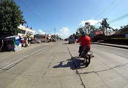
Isabela is accessible by all means of transportation. Almost 180-kilometers of the Pan-Philippine Highway pass through the different towns and cities of the province. Several bus companies offer daily trips to different routes like Manila, Dagupan, Baguio and Ilocos vice versa. Public utility vans and small-time bus operators ply daily trips from Tuguegarao in Cagayan to Santiago City vice versa, while jeepneys and tricycles are commonly used as the basic mode of transportation within the province's jurisdiction.
The construction of an 82-kilometer road through the protected Sierra Madre mountains is on-going to open access to three coastal towns of the province, despite opposition from environmentalists and leaders of the Catholic Church in the province. The P2.28-billion project will pass through the foothills of the 359,486-hectare Northern Sierra Madre mountain ranges and will take three years to complete. The project will improve an old logging road used by the defunct Acme Logging Corp. until the 1990s. It will start in Barangay Sindon Bayabo in the capital city of Ilagan and will end in Barangay Dicatian in the coastal town of Divilacan.
Travel to the coastal towns of Divilacan, Palanan and Maconacon is often made by boat or by plane. There are no roads that links the capital city of Ilagan to the coastal areas, depriving villagers of basic necessities and social services, such as health. Only light planes and boats are the available modes of transportation there, making it difficult to reach the coastal towns in times of emergencies and calamities. Once completed, the road project is expected to boost the economies of the coastal areas, citing Divilacan’s 119-hectares beach and freshwater areas that have lured tourists. The Protected Area Management Board (PAMB) issued Resolution No. 11, which reclassifies portions of the Sierra Madre as a special-use zone. The Agta and Dumagat in the area have also signed a memorandum of agreement with the provincial government, expressing their consent to the road project. At least 1,800 Agta and Dumagat have been staying in the park areas. But the impact of the road on the protected forest has alarmed the leaders of the Roman Catholic Diocese of Ilagan, who feared that the project may damage its forests and ecosystems. Even a former climate change advocate has urged provincial officials to put up safeguards and ensure that the Sierra Madre will be protected while the road is being built. The project was delayed in the recent years due to concerns about the road’s potential impact on the environment. The Cagayan Valley Regional Development Council required the project’s proponents to study the full impact of the road on the area’s biodiversity.
Airports and sea ports
There are three airports in the province. The Cauayan Airport is the primary airport in the province serving a trip to Manila, Palanan, and Maconacon. The other two are the Palanan Airport in Palanan and Maconacon Airport in Maconacon. The country’s leading passenger airline Cebu Pacific services the Cauayan-Manila-Cauayan Route. Light planes operated by Cyclone Airways and WCC Aviation’s Sky Pasada Have flights from Cauayan Domestic Airport to the community airports in Palanan and Maconacon. The province has two minor seaports, the Divilacan Port and Palanan Port in the coastal towns of Divilacan and Palanan. The trade going to the ports come primarily from major seaports in Cagayan such as Port of Aparri in Aparri, Cagayan, and Port of San Vicente and Port Irene, both in Santa Ana, Cagayan.
Education
Isabela is one of the primary centers of education in the Cagayan Valley Region. There are several public and private educational institutions, the most notable being the Isabela State University, a government-owned and controlled public university. Its main campus is located in Echague and satellite campuses in Cauayan City, Ilagan City, Angadanan, Cabagan, Jones, Palanan (extension), Roxas, San Mariano, San Mateo and Santiago City (extension).
Colleges and universities
Among the most notable higher educational institutions found in the province of Isabela are the following:
- Cagayan Valley Computer and Information Technology College Inc.
- East Asia International System College
- International Technological Institute of Arts and Tourism
- Isabela College of Arts and Technology (Marine School)
- Mallig Plains Colleges
- National Police College Regional Training School
- Northeastern College
- Northeast Luzon Adventist College
- Our Lady of the Pillar College — Cauayan Campus
- Our Lady of the Pillar College — San Manuel Campus
- Patria Sable Corpuz College
- Philippine Normal University — Alicia, Isabela Campus
- Saint Clare College of Region 2
- Saint Ferdinand College — Cabagan Campus
- Saint Ferdinand College — Ilagan (Main Campus)
- Santiago City Colleges
- Santiago City Polytechnic College
- STI Cauayan, Ilagan, and Santiago Campus
- Technical Education and Skills Development Authority
- University of La Salette
- University of Perpetual Help System — Isabela Campus
Tourism
Since the early 2000s, tourism has become an income-generating industry for Isabela. New hotels and resorts have opened, mostly in the cities of Ilagan, Cauayan and Santiago, and the towns of Tumauini, Gamu, Roxas, Alicia, Burgos, Ramon, San Mariano and Cordon. Top tourist attractions are the centuries-old churches; Magat Dam Tourism Complex, which houses Southeast Asia’s biggest dam; Santa Victoria Caves, Pinzal Falls and Ilagan Sanctuary at Fuyot National Park; the white sand beaches in the coastal municipalities of Maconacon, Divilacan, Palanan, Dinapigue and islands of coastal Isabela; the world’s biggest wooden lounge chair or butaka in Ilagan City; and various festival and fiestas, most famous of which is the Bambanti Festival annually celebrated every February, and the commemoration of the birth of the province during Isabela Day every May.
Places of interest
| Tourist attraction | Location |
|---|---|
| Abuan River | Ilagan |
| Aguinaldo Shrine — Historic capture and heroism of General Emilio Aguinaldo | Palanan |
| Balai na Ilagan | Ilagan |
| Balay Segundo Museum | Ramon |
| Balay na Santiago | Santiago City |
| Bonsai Park | Dinapigue |
| Borubor Falls | Roxas |
| Burmurbur Falls | Ilagan |
| Camp Samal — "Haven of Scouts" | Tumauini |
| Camp Vizcarra | Ramon |
| Crocodile Watching (Crocodylus mindorensis) | San Mariano |
| Desert Island | Divilacan |
| Dibulo Falls | Dinapigue |
| Dicotcotan Beach | Palanan |
| Dilaknadanum — is the home Agta people, a minority group on the coast of Isabela. Features forests, beaches, rivers and small farmsteads uprivers. | Palanan |
| Dimanek Falls | Palanan—San Mariano boundary ridge |
| Dinapigue Sea Wall | Dinapigue |
| Hanging Bridge | Maconacon |
| Honeymoon Island | Divilacan |
| Ilagan Sanctuary | Ilagan |
| Ilagan Japanese Tunnel | Ilagan |
| Isabela Museum and Library | Ilagan |
| La Salette Shrine — located in Balintocatoc Hills, contains life-sized statues of religious icons. | Santiago City |
| Maconacon Falls | Maconacon |
| Magat High Rise Dam — Asia’s biggest dam project at the time of its construction. It serves the primary function of power generation and irrigation. Its reservoir area of 4,450 hectares has a great potential for water-based recreation like fishing, boating and water skiing, among others. | Ramon |
| Mororan | Tumauini |
| Museo de Pattaraday | Santiago City |
| Obelisk | Jones |
| Pinzal Falls | Ilagan |
| Punta Amelita Resort | Cordon |
| Queen Isabela II Monument and Park | Ilagan (in front of the Isabela Provincial Capitol) |
| Sierra Madre Natural Forest Park | Isabela eastern coast |
| Sinavulluan Caves | Tumauini |
| Spring Garden Resort | Santiago City |
| Sta. Maria Triangular Park | Santa Maria |
| Sta. Victoria Caves | Ilagan |
| Villa Diana Resort | Cordon |
| Water Impounding Dam | Roxas |
| Waterworld Grand Resort | Ramon |
| White Sand Beaches — Typical of coastal areas along the Sierra Madre mountains of Cagayan Valley. | Dinapigue, Palanan, and Divilacan coastal towns |
| World's Largest Butaka — It is 11 feet 4 inches high, 20 feet 8 inches long, and 9 feet 7 inches wide. It weighs 2,368 kilos and was constructed by 25 workers in 29 days. | Ilagan |
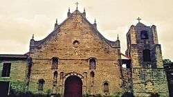


- San Pablo Church in San Pablo, the oldest town of Isabela founded by Padre de Santo Tomas on Nov. 30, 1646 (about 210 years before Isabela was made a province). Its six-level bell tower including the circular apex is made of adobe. It is said to be the oldest in Isabela and the tallest in Cagayan Valley.
- Saint Rose of Lima Church in Gamu is known for its Spanish architectural design. Built in 1726 during the Spanish time, the church façade was made of layered bricks and stones dating back during the 17th century and considered a pilgrimage church because of its antiquity. The feast of their patron, Saint Rose of Lima is celebrated every 23 August.
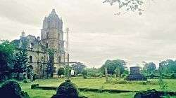
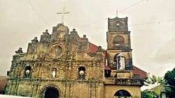
- Parish Church of St. Mathias in Tumauini was first built of light materials by Fray Francisco Muńez, O.P., and dedicated to Patron Saint Matthias, 1707. Separated from Cabagan and became regular parish, 1751. The church of stone with a unique cylindrical bell tower. The only of its kind in the Philippines was constructed by Father Domingo Forto. 1783 and completed, 1805. Became the capital of Isabela for a short time in 1890’s. It is an ultra-baroque church unique for its extensive use of baked clay both for wall finishing and ornamentation and bears Chinese ancestry. Partly damage during World War II and repaired into its original form by the faithful of Tumauini. This church was declared as a National Cultural Treasure on 24 February 1989.
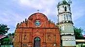
- Our Lady of Atocha in Alicia was originally built by the Spaniards in the 18th century. Passing by Angadanan on 12 February 1805, Fr. Manuel Mora, OP wrote that "Angadanan has a convent of bricks, though not totally finished. Its church is timber, wood, and bamboo. The number of inhabitants is 791." The church and convent as seen today in the town of Alicia, beautiful and antique, was built by Fr. Tomas Calderon, OP and inaugurated in 1849, with Fr. Francisco Gainza, OP, then vicar of Carig (now Santiago City). The church was dedicated to the Nuestra Señora de Atocha, more popularly known today as Our Lady of Atocha. The church is known for its antique Castilian architectural design and can be found along the Maharlika Highway and is accessible by land transport.
- Our Lady of the Pillar Church in Cauayan was constructed by Fray Juan Prieto with the first class materials with galvanized roofing and a ceiling of bricks, dedicated to Nuestra Señora del Pilar. It has a beautiful tower which was later destroyed by a violent earthquake. Now, only the façade of the Cauayan Church remains in its original form. The original belfry is in ruins while a new nave and belfry was constructed and like Tumauini, the facade has lots of interesting bas relief and portions of the bricks have numbers and symbols etched on it.
- Saint Ferdinand Parish Church (Ilagan City) — This church can’t be seen on the highways or the main national road as it was located in the center of the city of Ilagan. The church features very high ceilings and walls made of bricks. It was around 1696 and 1700 that Fr. Miguel Matos, OP, built the church of stone and bricks. A typhoon in 1866 destroyed the roof of the church. Desiring to make the church bigger, Fr. Pablo Almazan, OP, demolished the solid walls of the church, which, unfortunately, was never built. The walls of the church today are of modern make. It is known to house one of the oldest bells in the region. The church is dedicated to the patron saint, San Fernando.
- Shrine of Our Lady of the Visitation of Guibang in Gamu is located along the national highway frequented by travelers passing the Maharlika Highway. It is now known as the Guibang Basilica Minore because it comes alive on July of every year when religious pilgrims visit to offer prayers. The image of the Our Lady of the Visitation was canonically crowned by the Most Rev. Carmine Pocco, Papal Nuncio to the Philippines on May 26, 1973 at the former St. Ferdinand Cathedral (now St. Michael the Archangel Parish Church) in Gamu. The Catholic Bishops Conference of the Philippines at its 52nd Annual Bishop’s Meeting held in Tagaytay City in January 24–26, 1986 have approved the petition of His Excellency, the late Most Rev. Miguel Purugganan, former Bishop of the Diocese of Ilagan for the Church of Our Lady of the Visitation of Guibang to be called a National Shrine.
- Saint James Parish Church (Santiago City)
- Poor Saint Clare Monastery (Gamu)
- Cathedral of Saint Michael the Archangel (Gamu)
- Our Lady of La Salette Parish Church (Roxas)
- Saint Joseph the Worker (Echague)
- San Isidro de Labrador Church (San Isidro)
Festivals
| Festival | City/town | Notes |
|---|---|---|
| Baka Festival | San Pablo | A survey revealing quite number of ranches in San Pablo led to the establishment of the Baka Festival. Held every January 15, it aims to promote the local cattle industry. The festival also showcases cowboys of San Pablo displaying skills reminiscent of the American Wild West. |
| Balatong Festival | San Mateo | In San Mateo, mungo beans are packed with economic potential that it is referred to as "black gold". In previous years, the annual town fiesta promoted duck-related products during the Pato Festival. |
| Bambanti Festival | Province of Isabela | Celebrated annually by the entire province to honor the province's bountiful harvest and its emerging agro-industrial prowess. The festivity showcases the scarecrow dancing spectacles and agricultural booths. The municipalities and cities exhibit their respective culture, beliefs, traditions, origins and products. Annually, the event can drew at least 250,000 crowds all over the Cagayan Valley region, the biggest in the history of annual festivities in the region. It has become Isabela’s showcase of its rich cultural heritage and pristine natural beauty. Bambanti is an iluko word for "scarecrow". |
| Binallay Festival | Ilagan City | Ilagueños have made the binallay a symbol of the noble characteristics they aspire to have. These include being masipag (hardworking), matiyaga (patient), matalino (intelligent), and makadiyos (God fearing). According to them, they are patient because the process of preparing binallay is tedious and involves steaming the rice cake twice, hardworking because it is difficult to prepare the rice cake (the glutinous grains are ground the traditional way, with a stone mill), intelligent because it requires a special technique to peel the wrapper off so that none of the cake is wasted and God fearing because it is a delicacy associated with the Holy Week. They regard the white cake as a representation of the body of Christ and the laro as his blood. As part of their penitence during Holy Week, Binallay is the only food that Ilagueños eat. Every May, their signature product takes center stage twice, once during the festival itself and during the Isabela Day celebrations earlier in the month when it usually has a wider audience. |
| Binnadangan Festival | Roxas | A yearly celebration of Pagay Festival (Palay Festival) held every July 4. The Festival was popularly known as the Araw ng Roxas Celebration but it was declared formally as Pagay Festival during the reign of Mayor Benedict Calderon. It is celebrated because of the rich agricultural bounty of Roxas, being one of the towns that produce large stocks of rice. The festival features a parade mostly of politicians and participating schools from different parts of Roxas, kuliglig contest and cooking of the biggest rice cake that was also featured in the national television. Major events include a Street Dance Competition from different schools and Palarong Bayan. Due to a conflict in the name of the festival, by which the town of Alicia celebrates the same. It was changed to Binnadangan Festival by former Mayor Harry Soller. The Binnadangan comes from an Ilocano word meaning bayanihan and was also derived from the former name of the town during the 1600s. The festival ends with a long Pyromusical. |
| Dikit Festival | Aurora | Known for being an agricultural municipality, Aurora annually celebrates its Dikit Festival every 28th to 30 April. Dikit is an Ilocano term for "glutinous rice". The festival is celebrated to showcase this delicacy and its by-products which are bibingka, muriecos, inangit, tupig, kalamay and tinudok, among others. Farmers in Aurora plant this glutinous rice served to guests during special occasions. |
| Gakit Festival | Angadanan | An annual festival held at the Cagayan River. Participants of the festival offer fruits, vegetables, poultry, and livestock as thanksgiving for their abundant bounty. The practice also reminds Angadanians of their tradition of planting crops and raising poultry in their own backyards for their own consumption. The Gakit Festival also aims to show Angadanians that progress can only be achieved if they are united as one. A key detail of the festival is the hand-made bamboo rafts which are used by the participants. Each bamboo pole, if alone, has no value. It cannot float reliably on a river nor can it be used to transport anything. But if many bamboo poles are tied together as one, it can be made into a raft which can float and sail on calm or rough waters while transporting people and products. |
| Gawagaway-yan Festival | Cauayan City | The City Fiesta and the Feast of Our lady of the Pillar are celebrated annually on April 10–13 and October 10–12 respectively. Since its conversion into a component city on March 30, 2001, the City Government started to celebrate its founding anniversary with the conduct of "Gawagaway-yan Festival" aimed to preserve the rich cultural heritage of the city. It is highlighted by street dancing, beauty contest, trade fair, cultural parade, parlor games, free concert, band exhibition and other variety shows performed by local and Manila-based talents as well. |
| Isabela Day | Province of Isabela | Anniversary of the establishment of the civil government of Isabela in honor of Queen Isabella II of Spain. Activities like agro-industrial trade and tourism fairs, parades, sports events are conducted to entertain visitors. Also, one of the highlights of the celebration is the Miss Isabela, an extravagant colorful pageant featuring the candidates from each town/city of the province who exemplify Isabela’s youth and vibrancy. A grand fusion of fashion, music and dance with particular focus on Isabela’s tourism attractions and its leader. |
| Kankanen Festival | Cabatuan | Celebrated in Cabatuan, showcasing native delicacies made of glutinous rice. Mayor Alma Dayrit and the Rural Improvement Club started this annual tradition in 2003 and done on the Foundation Day rites of every year. |
| Mammangui Festival | Ilagan City | Celebrated by Ilagueño farmers as a thanksgiving activity for a bountiful harvest, Mammangui is an Ybanag word which means to harvest corn, the primary crop in the city. Since the assumption in office of Mayor Josemarie L. Diaz, Mammangui Festival was proclaimed as the official festivity of the city. During the celebration, different activities such as parlor games, cultural and trade fairs, colorful street dance, cook fest, sports events, cheerdance competitions, float parade and many others are conducted by the city government to showcase the past to present day transition of Ilagan's rich tradition and cultural heritage. Highlights of the celebration are the annual beauty pageants namely Little Miss Mammangui, Miss Gay Mammangui and the Miss Mammangui, which is one of the most prestigious of its kind in the valley and a free concert featuring local celebrities. It is annually celebrated every 29–31 May. |
| Mangi Festival | Tumauini | Corn (Zea mays) was one of the plants that came aboard the Spanish galleons to become one of the primary crops of the Philippines. The late National Artist for Dance, Ramon Obusan traced the origins of a traditional dance inspired by the crop to Tumauini. Thus, a corn-inspired festival seemed especially appropriate for Tumauini. |
| Nateng Festival | Mallig | |
| Nuang Festival | San Agustin | The carabao (Bubalus Bubalis Carabanesis), which remains a farmer’s indispensable helpmate in the fields, is honoured in the Nuang Festival of San Agustin as are the products the carabao enables farmers to produce. The town boasts of over 300 heads and farmers bring them over to the poblacion (town center) for the festival. To get the cattle there, they either guide the animals onto the ferry and keep them quiet for the short river crossing or find the shallowest point of the river, take off their clothes then lead them across. San Agustin supplies carabao milk to other towns where carabao milk candy is produced. The festival also serves as a venue for promoting other major products such as corn (Zea mays) and bananas (Musa paradisiaca L.). |
| Pagay Festival | Alicia | Held annually every September 28 in conjunction with the founding anniversary of the town of Alicia. It used to be called Alicia Town Festival, but was redefined and renamed to Pagay Festival in 2010 by Mayor Cecilia Claire N. Reyes. The festival aims to uphold the town's cultural identity and heritage and to promote the municipality’s primary agricultural product called, pagay (Ilocano word for rice) - the municipality’s major livelihood economy and trade mark. The festival is widely participated by the community which features various competitions (e.g., rice planting, harvesting, and cooking among others), street dance showdown, beauty pageant (Mutya ng Alicia), battle of the bands, and exhibits. However, the Pagay Parade is the main highlight of the festival that features decorated carabaos, various rice crop floats, and people marching with colorful costumes. |
| Pansi Festival | Cabagan | Pansi Festival is the official festivity of Cabagan.Pansi is an Ybanag word for pansit, a noodle dish topped with chopped karajay or lechon kawali in Tagalog. The town became noted for its well-known local product, the "Pansit Cabagan". |
| Pattaraday Festival | Santiago City | From pattaraday, an Ybanag word for "unity", the festival is celebrated in the city of Santiago to honor its founding anniversary, and the unity of the ethnolinguistic groups that have merged in the city to make it the melting pot of culture of Region II and contributed to the city’s progress and development-unity in action. Highlighted with the presentation of the Comedia – a moro-moro dance made famous by the Spaniards to stress the power of Christian Religion over the Moorish non-believers; other activities include beauty pageant, grand batalla presentations and a grand street dancing parade and exhibition with performers from other cities, provinces and regions. |
| Pinilisa Festival | Jones | |
| Sabutan Festival | Palanan | Held every March in Palanan, the festival is named after the local name for pandan (Pandanus tectorius) which is plentiful in the town. The people of Palanan are fine craftsmen who weave dyed and natural colored strips into a variety of bags, hats, and placemats, among other items that have both traditional and contemporary designs. For the festival, the sabutan products are not only sold, these are also used as a theme and are fashioned into costumes and décor. |
| Sinag-Banga Festival | San Isidro |
Notable residents
- Mutya Datul — Miss Supranational 2013 and Binibining Pilipinas - Supranational 2013
- Jejomar Binay — Former Vice President of the Republic of the Philippines
- Gilbert Teodoro — former secretary of the Department of National Defense
- Ruthlane Uy Asmundson — Mayor of Davis, California, USA
- Mark Clemence Telan — PBA Player
- Rogemar Menor — PBA Player
- General Mateo Noriel Luga
- Heherson Alvarez — former Senator
- Freddie Aguilar — Singer/composer
- Ricky Calimag — (Echague, Isabela) — PBA player
- Grace Padaca — former Governor of Isabela and former Commissioner of the Commission on Elections
- Silvestre Bello III — Secretary of the Department of Labor and Employment
Notes
- ↑ "List of Provinces". PSGC Interactive. Makati City, Philippines: National Statistical Coordination Board. Retrieved 8 January 2014.
- ↑ U.S. Corps of Engineers (1953). "Ilagan (topography map)". University of Texas in Austin Library. Retrieved on 2014-09-28.
- 1 2 3 4 "Region II (CAGAYAN VALLEY)". Census of Population (2015): Total Population by Province, City, Municipality and Barangay (Report). PSA. Retrieved 20 June 2016.
- ↑ "Isabela, top producer of corn". Bureau of Agricultural Statistics. Department of Agriculture (Philippines). Retrieved 27 February 2013.
- 1 2 "Brief History of Isabela". Fly Philippines. Retrieved 18 June 2011.
- ↑ Act No. 210, passed August 24, 1901.
- ↑ Republic of the Philippines, Commission on Elections (26 May 1995). "Resolution No. 2796 .". Manila Standard Today. Retrieved 19 June 2011.
- ↑ Robles, Chan. "Republic Act No. 7891 - An Act Dividing the Province of Isabela Into Two Provinces Namely: Isabela del Norte and Isabela del Sur". Philippine Laws, Statutes & Codes, and Republic Acts. Chan Robles Virtual Law Library. Retrieved 19 June 2011.
- ↑ Catindig, Raymund (February 28, 2011). "Marcos Mania still alive in Isabela 25 years after EDSA". Valley Journal News Online. Retrieved 19 June 2011.
- ↑ Isabela's Ilagan now a component city Philippine Star. Retrieved 08-15-2012
- ↑ Ilagan now 4th city in Cagayan Valley Philippine Daily Inquirer. Retrieved 08-15-2012
- ↑ [Ilagan Kicks Off Cityhood Bid http://www.mb.com.ph/articles/368552/ilagan-kicks-off-cityhood-bid] Manila Bulletin. Retrieved 08-11-2012
- 1 2 3 4 "Province: Isabela (province)". PSGC Interactive. Quezon City, Philippines: Philippine Statistics Authority. Retrieved 8 January 2016.
- ↑ gmanews.tv/story, Isabela gov sees big job ahead vs illegal logging
- ↑ iWitness: Si GOB at ang mga BUGADOR, 08/25/2008
- ↑ "Mount Cresta, Divilacan, Cagayan Valley, Philippines". Google Maps. Retrieved on 2014-09-28.
- 1 2 3 4 "Region II (CAGAYAN VALLEY)". Census of Population and Housing (2010): Total Population by Province, City, Municipality and Barangay (Report). NSO. Retrieved 29 June 2016.
- ↑ "Republic Act No. 10169; An Act Converting the Municipality of Ilagan in the Province of Isabela into a Component City to be Known as the City of Ilagan" (PDF). Senate of the Philippines. 21 June 2012. Retrieved 16 January 2016.
- ↑ Ilagan cityhood gets Senate nod Philippine Star. Retrieved April 11, 2012.
- ↑ "Robinsons Place Santiago Grand Opening Invitation". Flickr. Retrieved 18 January 2014.
- ↑ Top 10 Highest earning Philippine province Nobert Bermosa website. Retrieved 06-17-2012.
- ↑ "P3-M premyo ng Isabela bilang Best Corn Quality Awardee". Bombo Radyo. Retrieved 19 October 2013.
Further reading
- http://provinceofisabela.ph Official Website of the Province of Isabela. Retrieved October 3, 2014
- http://www.tourism.gov.ph/sitepages/FestivitiesList.aspx?festivityCode=292&monthCode=05. Retrieved October 8, 2014
- http://www.philstar.com/nation/2014/02/01/1285254/isabelas-bambanti-festival-lures-thousands Bambanti Festival. Retrieved October 8, 2014
- http://provinceofisabela.ph/index.php?option=com_content&view=article&id=168&catid=95. Retrieved October 8, 2014
- http://provinceofisabela.ph/index.php/tourism/festivals?showall=&limitstart=. Retrieved October 8, 2014
- http://www.rogerswebpoint.com/historyofcabatuan.htm Retrieved October 8, 2014
- http://www.spcicdtourism.com/#!festival/ccp2 Retrieved October 10, 2014
- http://www.manilatimes.net/renewable-energy-plant-to-rise-in-isabela/172957/ Renewable energy plant to rise in Isabela. Retrieved June 15, 2015
- http://news.pia.gov.ph/article/view/481433287402/p7-b-solar-power-plant-to-rise-in-isabela P7-B solar power plant to rise in Isabela. Retrieved June 15, 2015
- http://newsinfo.inquirer.net/742119/construction-of-p2-28-b-road-thru-sierra-madre-starts-amid-protests#ixzz3xK3EqC2O P2.28B road project for Ilagan-Divilacan Road Retrieved January 18, 2016
External links
-
 Media related to Isabela (province) at Wikimedia Commons
 -
 Geographic data related to Isabela (province) at OpenStreetMap
 - Philippine Standard Geographic Code
 |
Kalinga | Cagayan | | |
| Mountain Province Ifugao |
|
Philippine Sea | ||
| ||||
| | ||||
| Nueva Vizcaya | Quirino, Aurora |
Ilagan (capital) | |
| Municipalities |
|
| Component Cities | |
| Independent Component City |
|
| Barangays | |

