Masbate
| Masbate | |||
|---|---|---|---|
| Province | |||
| Province of Masbate | |||
|
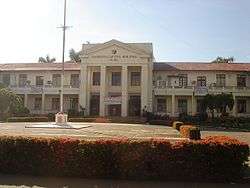
Masbate Provincial Capitol | |||
| |||
 Location within the Philippines | |||
| Coordinates: 12°10′N 123°35′E / 12.17°N 123.58°ECoordinates: 12°10′N 123°35′E / 12.17°N 123.58°E | |||
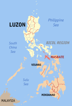
| Country | Philippines | ||
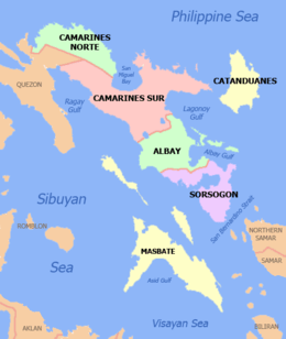
| Region | Bicol Region (Region V) | ||
| Founded | March 10, 1917 | ||
| Capital | Masbate City | ||
| Government | |||
| • Type | Sangguniang Panlalawigan | ||
| • Governor | Antonio T. Kho | ||
| • Vice Governor | Jo Kristine C. Revil | ||
| Area[1] | |||
| • Total | 4,151.78 km2 (1,603.01 sq mi) | ||
| Area rank | 30th out of 81 | ||
| Population (2015 census)[2] | |||
| • Total | 892,393 | ||
| • Rank | 29th out of 81 | ||
| • Density | 210/km2 (560/sq mi) | ||
| • Density rank | 43rd out of 81 | ||
| Divisions[3] | |||
| • Independent cities | 0 | ||
| • Component cities | |||
| • Municipalities | |||
| • Barangays | 550 | ||
| • Districts | 1st to 3rd districts of Masbate | ||
| Time zone | PST (UTC+8) | ||
| ZIP Code | 5400–5421 | ||
| IDD : area code | +63 (0)56 | ||
| ISO 3166 code | PH-MAS | ||
| Spoken languages | |||
| Website |
masbate | ||

Masbate, officially the Province of Masbate (Masbateño: Probinsya san Masbate; Hiligaynon: Kapuoran sang Masbate; Cebuano: Lalawigan sa Masbate; Waray: Probinsya han Masbate; Central Bikol: Probinsya kan Masbate) is an island province in the Philippines located near the middle of the nation's archipelago. Its capital is Masbate City and consists of three major islands: Masbate, Ticao and Burias. Masbate is at the crossroads of two island groups: Luzon and Visayas. Being administratively assigned to the Bicol Region, it is politically part of the Luzon island group. However, from a biogeographic and sociolinguistic perspective, Masbate has a stronger affiliation with Visayas.
History
[4] Masbate is one of the oldest settlements in the Philippines. Archaeological records show that Batungan (in Mandaon) and Bagumbayan (in Palanas) were major settlement sites during the Bronze Age (4000-1000 BC). The development of bronze metallurgy in South-East Asia coincided with an increasingly hierarchical society, firmly based on agricultural village settlements. It was these crucial changes, the introduction of new technologies, new social forms, and a new economic base, which culminated in the foundation of the proto-urban settlements of the 1st millennium AD. A fine stone chisel from Mount Batungan is dated to the twelfth century BC. Of the age of Philippine neoliths it is only possible to say that polished stone adzes from Masbate have been dated from 2710 BC to AD 179.2 Kalanay (in Aroroy) was an island site from 1000 BC-AD 850 (early metal). Masbate burial jars and a small pottery skull box found in caves dated to the beginning of the Christian era. Exquisite goldwork represents an old Philippine wealth in both an economic and an artistic sense: all sorts of wrought or molded ornaments and jewelry demonstrate both the availability of the raw material and the skill of the artisan – finger rings, earrings, head-bands, pendants and pectoral ornaments, heavy chains with interlocking serrated edges, light filigree work, delicate necklaces of fine twisted wires, 12-millimeter beads composed of 184 separate granules soldered together, thin hammered sheets for decorating grosser objects like earplugs or the visages of corpses, and a charming little snail of unknown use. Productive mines in Benguet, Butuan, Masbate, and Paracale were in operation and gold being panned in riverbeds all over the archipelago when the Spaniards arrived.
During the Spanish regime, San Jacinto in Ticao Island was an anchorage point for the Manila-Acapulco-Manila galleons. The course as described by the standard pilot’s guide of Cabrera Bueno was substantially that followed by nearly all the galleons. The largest variations were in the height at which the eastward crossing was made and in the course laid off the coast of the Californias.
The successive stages were as follows: from Cavite on Manila Bay out through one of the bocas, generally between Mariveles and Corregidor; thence SSW, keeping well clear of Fortun to the left and high Ambil to the right; past Cape Santiago on the Luzon Coast, and E between Mindoro and Maricaban; by the Punta de Escarceo, or “Tide Rip Point,” where currents run strong, and under Isla Verde, outside Subaang Bay, within which there was a fair anchorage in case of need; SE past the islets of Baco, with a good channel off Calapan; SE by E down the Mindoro coast by Punta Gorda de Pola; E by SE between the Tres Reyes and the Dos Hermanas; thence by the wide bocanabetween Marinduque and Banton, out onto the tablazo, or open water, above Sibuyan; SE by E between Burias and Masbate; turning ENE around the Punta de San Miguel and the Punta del Diablo; coasting around the east side of Ticao to the anchorage at San Jacinto; clearing from thence and working out seaward with the monsoon; E right leagues, with the dangerous Naranjos to starboard and the shoal of Calantas to port; NE by N and then ENE seven leagues around Capul; NE with the Sorsogon coast to port and San Bernardino to starboard and NE by E seven leagues to the Embocadero, with San Bernardino now to port and the island of Biri to starboard. At this point, according to Cabrera, “the rapid currents require skillful pilot work.” The galleon was now in the open sea.
From the chronicles of the early years of Spanish colonization, a relacion (report) about Masbate first appeared in Fray Martin de Rada‟s letter dated July 1569 to the Viceroy of New Spain (Mexico), Marquis de Falces. He mentioned that in a place called Masbat there were plenty of gold mines. Other later documents such as Artieda‟sRelacion (1573) and Andres de Mirandaola‟s letter (1574) refer to a place called Masbat or Masbad. It wasn‟t until 1582 that Miguel de Loarca wrote about a place called Masbate.
In the same year that the Augustinian Fray de Rada wrote about Masbat‟s gold mines, his fellow Augustinian Fray Alonzo Jimenez landed in Burias and baptized its chieftain Buaya. This baptism is said to be the very first baptism in Luzon. Fray Jimenez also built a church in Burias before he sailed on to Ibalon in 1570. By 1575, Masbate had become a priority in the Augustinian Missionary Memoranda. Fray Francisco de Ortega reported on the pillaging activities of a pirate named Caxabic in the islands of Masbate and Burias. By 1600, the Spaniards had developed Mobo as a galleon shipyard and San Jacinto as a strategic port. In 1605, Masbate was officially an Augustinian Mission and its first prior was Fray Francisco Guerrero. Masbate had about 250 tributes and 1000 Christian natives. In 1609, Fray Pedro de Arce, bishop-elect of Nueva Caceres, ceded the spiritual administration of Masbate to the Mitra (secular clergy). On May 28, 1682, bishop-elect Dominican Fray Andres Gonzales petitioned the King of Spain to revert some curacies of Nueva Caceres to the charge of religious communities. The petition was approved in 1685 and by 1687, the first Augustinian Recollect missionaries had sailed for the port of San Jacinto to begin the Recollect Mission in Masbate. In 1700, Fray Ildefonso de la Concepcion established the settlement of Uson as a visita(barrio) of Mobo. The town of Masbate was established in 1791 by Fray Manuel delaVirgendel Tremedal.
The jurisdiction of Nueva Caceres embraced the entire provinces of Camarines and Albay, as far as and including the islands of Ticao, Masbate, Burias, and Catanduanes; the province of Tayabas, as far as and including Lucban; and in the opposite coast of Maobàn, to Binangonan, Polo, Baler, and Casiguran. At one time, it was governed by his very illustrious Lordship Doctor Don Ysidoro de Arevalo, who was the bishop-elect. Records show that he enjoyed a yearly stipend of 4,000 pesos of common gold, in conformance with a royal decree. Likewise a payment was made from the royal treasury, in virtue of a decree by the supreme government and the council of the royal treasury dated October 2, 1723, 200 pesos, for priests of the choir, at 100 pesos each, as assistants of the aforesaid illustrious lord. Another payment was made of 400 pesos, assigned to this church by the royal decree, dated at San Yldefonso on August 19, 1736; for the pay of singers, sacristans, and doorkeepers, and other expenses for worship and for the [care of the] building of the church. It likewise had a contribution of 232 pesos, 4 tomins, which was paid in 6 quintals of wax, l00 gantas of coconut-oil, and 4 arrobas of Castilian wine, in conformity with another royal decree dated February 21, 1705.
The administration of Masbate was given back to the Mitra after the Recollects left Masbate in 1794. All in all, over 60 Recollect missionaries were assigned in Masbate for a period of more than 100 years. Masbate became a separate politico-military command province in 1846. In 1864, it was declared a separate province from Albay. After a devastating typhoon in 1908, Masbate was annexed to the province of Sorsogon. It finally gained status as a separate province on December 15, 1920 by virtue of Commonwealth Act No. 2934.
Geography
The province lies roughly at the center of the Philippine archipelago, between latitudes 11°43’ north and 123°09’ east and 124°5’ east. It is bounded on the north by Burias and Ticao Pass, east by San Bernardino Strait, south by the Visayan Sea, and west by the Sibuyan Sea. Relative to mainland Bicol, the province faces the southwestern coasts of Camarines Sur, Albay, and Sorsogon areas. Masbate covers a total area of 4,151.78 square kilometres (1,603.01 sq mi).[5]
The general surface configuration of the province ranges from slightly undulating to rolling and from hilly to mountainous. In each island, the rugged topography is concentrated in the northeastern portion and gradually recedes to blunt hills and rolling areas in the south, southeast, and southwest.
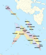
Administrative divisions
Masbate comprises 20 municipalities and one city, all encompassed by 3 congressional districts.
- † Provincial capital and component city
- Municipality
| ||||||||||||||||||||||||||||||||||||||||||||||||||||||||||||||||||||||||||||||||||||||||||||||||||||||||||||||||||||||||||||||||||||||||||||||||||||||||||||||||||||||||||||||||||||||||||||||||||||||||||||||||||||||||||||||||||||||||||||||||||||||||||||||||||||||||||||||||||||||||||||||||||||||||||||||||||||||||||||||
Demographics
| Population census of Masbate | ||
|---|---|---|
| Year | Pop. | ±% p.a. |
| 1903 | 43,675 | — |
| 1918 | 67,513 | +2.95% |
| 1939 | 182,483 | +4.85% |
| 1948 | 211,113 | +1.63% |
| 1960 | 335,971 | +3.95% |
| 1970 | 492,908 | +3.90% |
| 1975 | 533,387 | +1.60% |
| 1980 | 584,520 | +1.85% |
| 1990 | 599,355 | +0.25% |
| 1995 | 653,852 | +1.64% |
| 2000 | 707,668 | +1.71% |
| 2007 | 768,939 | +1.15% |
| 2010 | 834,650 | +3.03% |
| 2015 | 892,393 | +1.28% |
| Source: Philippine Statistics Authority[2][6][6][7] | ||
The population of Masbate in the 2015 census was 892,393 people,[2] with a density of 210 inhabitants per square kilometre or 540 inhabitants per square mile.
Language
The people speak predominantly Masbateño (or Minasbate, the language unique to the province related to Visayan languages) and to lesser degree, Bicolano. Other Visayan languages are also spoken, with 33% of the population speaking Hiligaynon/Ilonggo, mainly in the towns of Balud, Mandaon and the southwestern part of Milagros, while the remaining 9% speak Cebuano, especially in the towns of Esperanza, Pio V. Corpuz and Placer. In northeastern Burias Island, they speak Bicolano similarly as the people of Camarines Sur and Albay, due to the island’s proximity to the Bicol Region mainland. The people generally speak fluent English and Filipino, though is seldom used everyday.
Religion
About 91% of the population are members of the Catholic Church (Statistics by Diocese Hierarchy, 2014). Devotional practices such as the rosary, novenas to saints, and other religious manifestations as processions, the Misa de Gallo and Holy Week traditional activities are still very much part of the way of life of most parishioners. The Diocese of Masbate was created on March 23, 1968, separating it from the Diocese of Sorsogon. It comprises then, and now, the civil province of Masbate with its 121 islands including the two larger ones Burias and Ticao. It is now a suffragan of the Archdiocese of Caceres. Its titular patron is St. Anthony of Padua.
There are a total 22 parishes in the Diocese of Masbate, ministered to by 43 priests and 11 religious sisters. It has 1 minor seminary, 4 pastoral centers, 3 elementary schools, 6 high schools, 1 college and 7 kindergarten schools. And among its faith communities are 20 BEC's 46 neo-catechumenal communities, 11 mandated organizations and 3 charismatic groups. Other denominations include the Aglipayan Church, the Members Church of God International, popularly called Ang Dating Daan, Jesus Miracle Crusade, Iglesia ni Cristo (Church of Christ) which also functions many religious and social events in the province, as well as Baptist, Methodist, The Church of Jesus Christ of Latter-day Saints (Mormons), Jehovah's Witnesses, Seventh-day Adventist and other Christians. Non Christians are also present which is commonly represented by Moslems.
Literacy
The literacy rate of the province stood at 95.90%.
Economy
Masbate is endowed with rich natural resources. In line with its agriculture are other industries such as large farming, livestock and poultry raising. Along its coastal areas, fishing industry predominates. Agricultural lands are planted with rice, corn, rootcrops and coconut.
Masbate ranks second only to Bukidnon in raising cattle. About 70% of these are sold to Metro Manila and other provinces in Luzon and Visayas. Farming is the main source of livelihood. Copra is the leading product, followed by corn, rice and rootcrops. Fishing is a major industry along the coast.
Manufacturing firms are in the copra industry, handicrafts, furnituremaking and fish processing.
Rich minerals are found in the province. Masbate is described by geologists as a province sitting on a "pot of gold". Other minerals found in the area are manganese, copper, silver, iron, chromite, limestone, guano, and carbon.
Cottage industries such as furniture and cabinet making, ceramics, garments, handicrafts and metalcrafts, are likewise source of livelihood.
Infrastructure
An agricultural province, Masbate remains a net importer of consumer and industrial products. The supply of goods came from Metro Manila, Cebu, Panay and Bicol Provinces. Construction materials, particularly cement, are sometimes sourced as a far as Iligan City in Mindanao.
Education
Major institutions of higher learning in the province include the state-supported Dr. Emilio B. Espinosa Sr. Memorial State College of Agriculture and Technology in Mandaon and in Masbate City, Osmeña Colleges, Masbate Colleges, Liceo de Masbate (a Catholic school with primary, secondary and tertiary educations under the directorship of the Diocese of Masbate), Southern Bicol College, Cataingan Municipal College. Masbate also has national schools in Cataingan, Placer, San Jacinto, Mandaon, Mobo, and Masbate City.
Other educational institutions include public and private schools such as the Masbate National Comprehensive High School in Masbate City that has three campuses — (MNCHS-Bolo Campus, MNCHS-Main Campus, MNCHS-Annex Campus), Holy Name Academy (a Catholic institution run by the Augustinian Recollect Sisters in Palanas, Masbate) and Lucio Atabay Memorial Elementary School (formerly, Nipa Elem. School) in Nipa, Palanas, Masbate.
References
- ↑ "List of Provinces". PSGC Interactive. Makati City, Philippines: National Statistical Coordination Board. Retrieved 24 January 2013.
- 1 2 3 4 "Region V (BICOL REGION)". Census of Population (2015): Total Population by Province, City, Municipality and Barangay (Report). PSA. Retrieved 20 June 2016.
- ↑ "Region: REGION V (Bicol Region)". PSGC Interactive. Makati City, Philippines: National Statistical Coordination Board. Retrieved 24 January 2013.
- ↑ http://masbate.gov.ph/governor/history-of-masbate
- 1 2 3 "Province: Masbate". PSGC Interactive. Quezon City, Philippines: Philippine Statistics Authority. Retrieved 8 January 2016.
- 1 2 3 "Region V (BICOL REGION)". Census of Population and Housing (2010): Total Population by Province, City, Municipality and Barangay (Report). NSO. Retrieved 29 June 2016.
- ↑ "Census 2000; Population and Housing; Region V" (PDF). Philippine Statistics Authority (National Statistics Office - Region V). Retrieved 29 June 2016.
- ↑ Table 4. Household Population by Ethnicity and Sex: Masbate, 2000
External links
-
 Masbate travel guide from Wikivoyage
 -
 Media related to Masbate at Wikimedia Commons
 -
 Geographic data related to Masbate at OpenStreetMap
 - Masbate Province Official Site
- Local Governance Performance Management System
 |
Quezon / Sibuyan Sea | Ragay Gulf | Burias Pass / Albay Ticao Pass / Sorsogon |
|
| Romblon / Sibuyan Sea | |
Samar Sea / Northern Samar Western Samar | ||
| ||||
| | ||||
| Capiz / Jintotolo Channel | Visayan Sea Cebu |
Samar Sea / Biliran Leyte |
Masbate City (capital) | |
| Municipalities | |
| Component city | |