| |
|---|
|
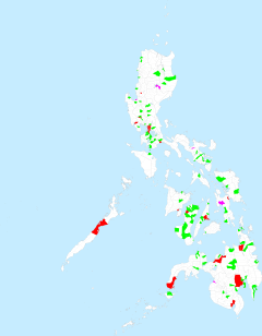
Metro area [1] |
Population (2015) [3] |
Area [4][5] |
Density (2015) |
Managing agency |
|
|
km2 |
sq mi |
/km2 |
/sq mi |
|
|
Metro Angeles |
1,132,933 |
596.89 |
230.46 |
1,900 |
4,900 |
— |
| 15°08′24″N 120°35′16″E / 15.1399°N 120.5879°E / 15.1399; 120.5879 (Angeles) |
Angeles |
7001363009999900000♠36.3% | 411,634 |
60.27 |
23.27 |
6,800 |
18,000 |
| 14°59′47″N 120°39′05″E / 14.9965°N 120.6513°E / 14.9965; 120.6513 (Bacolor) |
Bacolor |
7000350000000000000♠3.5% | 39,460 |
71.70 |
27.68 |
550 |
1,400 |
| 15°13′22″N 120°34′24″E / 15.2228°N 120.5733°E / 15.2228; 120.5733 (Mabalacat) |
Mabalacat |
7001221000000000000♠22.1% | 250,799 |
83.18 |
32.12 |
3,000 |
7,800 |
| 15°04′20″N 120°32′28″E / 15.0723°N 120.5411°E / 15.0723; 120.5411 (Porac) |
Porac |
7001110000000000000♠11.0% | 124,381 |
314.00 |
121.24 |
400 |
1,000 |
| 15°01′45″N 120°41′34″E / 15.0292°N 120.6928°E / 15.0292; 120.6928 (San Fernando, Pampanga) |
San Fernando |
7001271000000000000♠27.1% | 306,659 |
67.74 |
26.15 |
4,500 |
12,000 |
|
Metro Bacolod |
791,019 |
578.65 |
223.42 |
1,400 |
3,600 |
— |
| 10°40′34″N 122°57′05″E / 10.6762°N 122.9513°E / 10.6762; 122.9513 (Bacolod) |
Bacolod |
7001710000000000000♠71.0% | 561,875 |
162.67 |
62.81 |
3,500 |
9,100 |
| 10°47′52″N 122°58′23″E / 10.7977°N 122.9730°E / 10.7977; 122.9730 (Silay) |
Silay |
7001160000000000000♠16.0% | 126,930 |
214.80 |
82.93 |
590 |
1,500 |
| 10°44′14″N 122°58′02″E / 10.7372°N 122.9673°E / 10.7372; 122.9673 (Talisay) |
Talisay |
7001129000000000000♠12.9% | 102,214 |
201.18 |
77.68 |
510 |
1,300 |
|
Metro Baguio (BLISTT) |
611,316 |
1,081.43 |
417.54 |
570 |
1,500 |
— |
| 16°24′43″N 120°35′36″E / 16.4120°N 120.5933°E / 16.4120; 120.5933 (Baguio) |
Baguio |
7001565000000000000♠56.5% | 345,366 |
57.51 |
22.20 |
6,000 |
16,000 |
| 16°21′34″N 120°40′38″E / 16.3595°N 120.6773°E / 16.3595; 120.6773 (Itogon) |
Itogon |
7000980000000000000♠9.8% | 59,820 |
449.73 |
173.64 |
130 |
340 |
| 16°27′42″N 120°35′19″E / 16.4617°N 120.5885°E / 16.4617; 120.5885 (La Trinidad) |
La Trinidad |
7001211000000000000♠21.1% | 129,133 |
70.04 |
27.04 |
1,800 |
4,700 |
| 16°29′45″N 120°29′17″E / 16.4959°N 120.4880°E / 16.4959; 120.4880 (Sablan) |
Sablan |
7000190000000000000♠1.9% | 11,457 |
105.63 |
40.78 |
110 |
280 |
| 16°23′34″N 120°33′44″E / 16.3927°N 120.5622°E / 16.3927; 120.5622 (Tuba) |
Tuba |
7000780000000000000♠7.8% | 47,648 |
295.97 |
114.27 |
160 |
410 |
| 16°28′30″N 120°37′58″E / 16.4751°N 120.6329°E / 16.4751; 120.6329 (Tublay) |
Tublay |
7000290000000000000♠2.9% | 17,892 |
102.55 |
39.59 |
170 |
440 |
|
Metro Batangas |
486,595 |
386.97 |
149.41 |
1,300 |
3,400 |
— |
| 13°45′22″N 121°03′28″E / 13.7561°N 121.0577°E / 13.7561; 121.0577 (Batangas City) |
Batangas City |
7001678000000000000♠67.8% | 329,874 |
282.96 |
109.25 |
1,200 |
3,100 |
| 13°47′33″N 121°00′27″E / 13.7925°N 121.0076°E / 13.7925; 121.0076 (Bauan) |
Bauan |
7001188000000000000♠18.8% | 91,297 |
53.31 |
20.58 |
1,700 |
4,400 |
| 13°47′04″N 121°01′49″E / 13.7844°N 121.0302°E / 13.7844; 121.0302 (San Pascual) |
San Pascual |
7001134000000000000♠13.4% | 65,424 |
50.70 |
19.58 |
1,300 |
3,400 |
|
Metro Cagayan de Oro |
1,376,343 |
4,323.16 |
1,669.18 |
320 |
830 |
— |
| 8°34′13″N 124°28′16″E / 8.5704°N 124.4711°E / 8.5704; 124.4711 (Alubijid) |
Alubijid |
7000220000000000000♠2.2% | 29,724 |
85.56 |
33.03 |
350 |
910 |
| 8°18′45″N 124°41′14″E / 8.3125°N 124.6871°E / 8.3125; 124.6871 (Baungon) |
Baungon |
7000250000000000000♠2.5% | 34,336 |
328.34 |
126.77 |
100 |
260 |
| 8°29′03″N 124°38′50″E / 8.4842°N 124.6472°E / 8.4842; 124.6472 (Cagayan de Oro) |
Cagayan de Oro |
7001491000000000000♠49.1% | 675,950 |
412.80 |
159.38 |
1,600 |
4,100 |
| 8°36′44″N 124°53′34″E / 8.6123°N 124.8929°E / 8.6123; 124.8929 (Claveria) |
Claveria |
7000360000000000000♠3.6% | 48,906 |
579.63 |
223.80 |
84 |
220 |
| 8°33′40″N 124°31′28″E / 8.5611°N 124.5244°E / 8.5611; 124.5244 (El Salvador) |
El Salvador |
7000360000000000000♠3.6% | 50,204 |
106.15 |
40.98 |
470 |
1,200 |
| 8°35′40″N 124°24′21″E / 8.5944°N 124.4057°E / 8.5944; 124.4057 (Gitagum) |
Gitagum |
7000120000000000000♠1.2% | 16,373 |
43.40 |
16.76 |
380 |
980 |
| 8°39′06″N 124°45′13″E / 8.6516°N 124.7535°E / 8.6516; 124.7535 (Jasaan) |
Jasaan |
7000400000000000000♠4.0% | 54,478 |
77.02 |
29.74 |
710 |
1,800 |
| 8°34′29″N 124°26′27″E / 8.5747°N 124.4408°E / 8.5747; 124.4408 (Laguindingan) |
Laguindingan |
7000180000000000000♠1.8% | 24,405 |
44.23 |
17.08 |
550 |
1,400 |
| 8°20′05″N 124°44′37″E / 8.3346°N 124.7435°E / 8.3346; 124.7435 (Libona) |
Libona |
7000320000000000000♠3.2% | 43,969 |
374.37 |
144.55 |
120 |
310 |
| 8°32′11″N 124°52′45″E / 8.5363°N 124.8792°E / 8.5363; 124.8792 (Malitbog) |
Malitbog |
7000180000000000000♠1.8% | 24,453 |
581.85 |
224.65 |
42 |
110 |
| 8°21′57″N 124°51′49″E / 8.3659°N 124.8637°E / 8.3659; 124.8637 (Manolo Fortich) |
Manolo Fortich |
7000730000000000000♠7.3% | 100,210 |
413.60 |
159.69 |
240 |
620 |
| 8°31′16″N 124°34′29″E / 8.5212°N 124.5747°E / 8.5212; 124.5747 (Opol) |
Opol |
7000450000000000000♠4.5% | 61,503 |
175.13 |
67.62 |
350 |
910 |
| 8°19′37″N 124°58′40″E / 8.3270°N 124.9779°E / 8.3270; 124.9779 (Sumilao) |
Sumilao |
7000200000000000000♠2.0% | 27,660 |
196.95 |
76.04 |
140 |
360 |
| 8°32′21″N 124°45′14″E / 8.5391°N 124.7538°E / 8.5391; 124.7538 (Tagoloan) |
Tagoloan |
7000530000000000000♠5.3% | 73,150 |
117.73 |
45.46 |
620 |
1,600 |
| 8°13′56″N 124°36′13″E / 8.2322°N 124.6035°E / 8.2322; 124.6035 (Talakag) |
Talakag |
7000520000000000000♠5.2% | 71,644 |
786.40 |
303.63 |
91 |
240 |
| 8°35′09″N 124°46′13″E / 8.5859°N 124.7704°E / 8.5859; 124.7704 (Villanueva) |
Villanueva |
7000290000000000000♠2.9% | 39,378 |
48.80 |
18.84 |
810 |
2,100 |
|
Metro Cebu |
2,849,213 |
1,053.19 |
406.64 |
2,700 |
7,000 |
Metropolitan Cebu Development Coordination Board |
| 10°06′12″N 123°38′26″E / 10.1033°N 123.6405°E / 10.1033; 123.6405 (Carcar) |
Carcar |
7000420000000000000♠4.2% | 119,664 |
116.78 |
45.09 |
1,000 |
2,600 |
| 10°18′32″N 123°53′35″E / 10.3090°N 123.8930°E / 10.3090; 123.8930 (Cebu City) |
Cebu City |
7001324000000000000♠32.4% | 922,611 |
315.00 |
121.62 |
2,900 |
7,500 |
| 10°27′26″N 124°00′37″E / 10.4571°N 124.0104°E / 10.4571; 124.0104 (Compostela) |
Compostela |
7000170000000000000♠1.7% | 47,898 |
53.90 |
20.81 |
890 |
2,300 |
| 10°22′35″N 123°57′26″E / 10.3765°N 123.9572°E / 10.3765; 123.9572 (Consolacion) |
Consolacion |
7000460000000099999♠4.6% | 131,528 |
37.03 |
14.30 |
3,600 |
9,300 |
| 10°15′05″N 123°57′00″E / 10.2515°N 123.9499°E / 10.2515; 123.9499 (Cordova) |
Cordova |
7000210000000000000♠2.1% | 59,712 |
17.15 |
6.62 |
3,500 |
9,100 |
| 10°31′14″N 124°01′37″E / 10.5205°N 124.0270°E / 10.5205; 124.0270 (Danao) |
Danao |
7000480000000000000♠4.8% | 136,471 |
107.30 |
41.43 |
1,300 |
3,400 |
| 10°18′39″N 123°56′58″E / 10.3109°N 123.9494°E / 10.3109; 123.9494 (Lapu-Lapu) |
Lapu-Lapu (Opon) |
7001143000000000000♠14.3% | 408,112 |
58.10 |
22.43 |
7,000 |
18,000 |
| 10°24′01″N 123°59′57″E / 10.4002°N 123.9993°E / 10.4002; 123.9993 (Liloan) |
Liloan |
7000420000000000000♠4.2% | 118,753 |
45.92 |
17.73 |
2,600 |
6,700 |
| 10°19′28″N 123°56′34″E / 10.3245°N 123.9428°E / 10.3245; 123.9428 (Mandaue) |
Mandaue |
7001127000000000000♠12.7% | 362,654 |
25.18 |
9.72 |
14,000 |
36,000 |
| 10°14′42″N 123°47′47″E / 10.2450°N 123.7964°E / 10.2450; 123.7964 (Minglanilla) |
Minglanilla |
7000460000000099999♠4.6% | 132,135 |
65.60 |
25.33 |
2,000 |
5,200 |
| 10°12′33″N 123°45′24″E / 10.2093°N 123.7567°E / 10.2093; 123.7567 (Naga) |
Naga |
7000410009999999999♠4.1% | 115,750 |
101.97 |
39.37 |
1,100 |
2,800 |
| 10°09′51″N 123°42′21″E / 10.1643°N 123.7058°E / 10.1643; 123.7058 (San Fernando) |
San Fernando |
7000230000000099999♠2.3% | 66,280 |
69.39 |
26.79 |
960 |
2,500 |
| 10°14′41″N 123°50′50″E / 10.2446°N 123.8473°E / 10.2446; 123.8473 (Talisay) |
Talisay |
7000800000000000000♠8.0% | 227,645 |
39.87 |
15.39 |
5,700 |
15,000 |
|
Metro Dagupan (CAMADA) |
372,756 |
134.06 |
51.76 |
2,800 |
7,300 |
— |
| 16°00′32″N 120°21′26″E / 16.0089°N 120.3571°E / 16.0089; 120.3571 (Calasiao) |
Calasiao |
7001255000000000000♠25.5% | 95,154 |
48.36 |
18.67 |
2,000 |
5,200 |
| 16°02′33″N 120°20′15″E / 16.0424°N 120.3375°E / 16.0424; 120.3375 (Dagupan) |
Dagupan |
7001459000000000000♠45.9% | 171,271 |
37.23 |
14.37 |
4,600 |
12,000 |
| 16°04′00″N 120°24′04″E / 16.0666°N 120.4010°E / 16.0666; 120.4010 (Mangaldan) |
Mangaldan |
7001285000000000000♠28.5% | 106,331 |
48.47 |
18.71 |
2,200 |
5,700 |
|
Metro Davao |
2,516,216 |
3,964.95 |
1,530.88 |
630 |
1,600 |
Davao Regional Development Council |
| 7°21′20″N 125°42′16″E / 7.3556°N 125.7045°E / 7.3556; 125.7045 (Carmen) |
Carmen |
7000300000000000000♠3.0% | 74,679 |
166.00 |
64.09 |
450 |
1,200 |
| 7°03′50″N 125°36′30″E / 7.0639°N 125.6083°E / 7.0639; 125.6083 (Davao City) |
Davao City |
7001649000000000000♠64.9% | 1,632,991 |
2,443.61 |
943.48 |
670 |
1,700 |
| 6°44′39″N 125°21′23″E / 6.7443°N 125.3565°E / 6.7443; 125.3565 (Digos) |
Digos |
7000670000000000000♠6.7% | 169,393 |
287.10 |
110.85 |
590 |
1,500 |
| 7°18′01″N 125°40′57″E / 7.3004°N 125.6826°E / 7.3004; 125.6826 (Panabo) |
Panabo |
7000730000000000000♠7.3% | 184,599 |
251.23 |
97.00 |
730 |
1,900 |
| 7°04′28″N 125°42′31″E / 7.0744°N 125.7086°E / 7.0744; 125.7086 (Samal) |
Samal |
7000410009999999999♠4.1% | 104,123 |
301.30 |
116.33 |
350 |
910 |
| 6°50′02″N 125°24′55″E / 6.8340°N 125.4154°E / 6.8340; 125.4154 (Santa Cruz) |
Santa Cruz |
7000360000000000000♠3.6% | 90,987 |
319.91 |
123.52 |
280 |
730 |
| 7°26′48″N 125°48′34″E / 7.4468°N 125.8095°E / 7.4468; 125.8095 (Tagum) |
Tagum |
7001103000000000000♠10.3% | 259,444 |
195.80 |
75.60 |
1,300 |
3,400 |
|
Metro Iloilo-Guimaras |
946,146 |
1,105.53 |
426.85 |
860 |
2,200 |
Metro Iloilo-Guimaras Economic Development Council |
| 10°41′49″N 122°38′52″E / 10.6970°N 122.6479°E / 10.6970; 122.6479 (Buenavista) |
Buenavista |
7000530000000000000♠5.3% | 50,437 |
128.26 |
49.52 |
390 |
1,000 |
| 10°52′49″N 122°28′53″E / 10.8803°N 122.4815°E / 10.8803; 122.4815 (Cabatuan) |
Cabatuan |
7000620000000000000♠6.2% | 58,442 |
112.90 |
43.59 |
520 |
1,300 |
| 10°42′09″N 122°34′08″E / 10.7024°N 122.5690°E / 10.7024; 122.5690 (Iloilo City) |
Iloilo City |
7001473000000000000♠47.3% | 447,992 |
78.34 |
30.25 |
5,700 |
15,000 |
| 10°39′40″N 122°35′27″E / 10.6611°N 122.5909°E / 10.6611; 122.5909 (Jordan) |
Jordan |
7000380000000000000♠3.8% | 36,096 |
126.11 |
48.69 |
290 |
750 |
| 10°47′11″N 122°35′21″E / 10.7863°N 122.5892°E / 10.7863; 122.5892 (Leganes) |
Leganes |
7000340000000000000♠3.4% | 32,480 |
32.20 |
12.43 |
1,000 |
2,600 |
| 10°31′35″N 122°32′23″E / 10.5265°N 122.5396°E / 10.5265; 122.5396 (Nueva Valencia) |
Nueva Valencia |
7000420000000000000♠4.2% | 39,810 |
137.12 |
52.94 |
290 |
750 |
| 10°41′37″N 122°28′38″E / 10.6936°N 122.4773°E / 10.6936; 122.4773 (Oton) |
Oton |
7000940000000000000♠9.4% | 89,115 |
86.44 |
33.37 |
1,000 |
2,600 |
| 10°46′29″N 122°32′31″E / 10.7748°N 122.5419°E / 10.7748; 122.5419 (Pavia) |
Pavia |
7000590000000000000♠5.9% | 55,603 |
27.15 |
10.48 |
2,000 |
5,200 |
| 10°35′29″N 122°42′09″E / 10.5913°N 122.7024°E / 10.5913; 122.7024 (San Lorenzo) |
San Lorenzo |
7000280000000099999♠2.8% | 26,112 |
93.04 |
35.92 |
280 |
730 |
| 10°46′51″N 122°27′54″E / 10.7807°N 122.4650°E / 10.7807; 122.4650 (San Miguel) |
San Miguel |
7000290000000000000♠2.9% | 27,686 |
31.97 |
12.34 |
870 |
2,300 |
| 10°49′38″N 122°31′53″E / 10.8272°N 122.5314°E / 10.8272; 122.5314 (Santa Barbara) |
Santa Barbara |
7000640000000000000♠6.4% | 60,215 |
131.96 |
50.95 |
460 |
1,200 |
| 10°30′10″N 122°37′49″E / 10.5028°N 122.6304°E / 10.5028; 122.6304 (Sibunag) |
Sibunag |
7000230000000099999♠2.3% | 22,158 |
120.04 |
46.35 |
180 |
470 |
|
Metro Manila |
12,877,253 |
633.11 |
244.45 |
20,000 |
52,000 |
Metropolitan Manila Development Authority |
| 14°39′26″N 120°59′03″E / 14.6571°N 120.9841°E / 14.6571; 120.9841 (Caloocan) |
Caloocan |
7001123000000000000♠12.3% | 1,583,978 |
55.80 |
21.54 |
28,000 |
73,000 |
| 14°28′50″N 120°58′55″E / 14.4806°N 120.9819°E / 14.4806; 120.9819 (Las Piñas) |
Las Piñas |
7000460000000099999♠4.6% | 588,894 |
32.69 |
12.62 |
18,000 |
47,000 |
| 14°33′24″N 121°01′25″E / 14.5568°N 121.0235°E / 14.5568; 121.0235 (Makati) |
Makati |
7000450000000000000♠4.5% | 582,602 |
21.57 |
8.33 |
27,000 |
70,000 |
| 14°40′31″N 120°57′26″E / 14.6752°N 120.9573°E / 14.6752; 120.9573 (Malabon) |
Malabon |
7000280000000099999♠2.8% | 365,525 |
15.71 |
6.07 |
23,000 |
60,000 |
| 14°34′39″N 121°02′00″E / 14.5774°N 121.0334°E / 14.5774; 121.0334 (Mandaluyong) |
Mandaluyong |
7000300000000000000♠3.0% | 386,276 |
9.29 |
3.59 |
42,000 |
110,000 |
| 14°35′26″N 120°58′48″E / 14.5906°N 120.9799°E / 14.5906; 120.9799 (Manila) |
Manila |
7001138000000000000♠13.8% | 1,780,148 |
38.55 |
14.88 |
46,000 |
120,000 |
| 14°37′59″N 121°05′57″E / 14.6331°N 121.0993°E / 14.6331; 121.0993 (Marikina) |
Marikina |
7000350000000000000♠3.5% | 450,741 |
21.52 |
8.31 |
21,000 |
54,000 |
| 15°42′47″N 120°54′15″E / 15.7131°N 120.9041°E / 15.7131; 120.9041 (Muntinlupa) |
Muntinlupa |
7000390000000000000♠3.9% | 504,509 |
39.75 |
15.35 |
13,000 |
34,000 |
| 14°39′25″N 120°56′52″E / 14.6569°N 120.9478°E / 14.6569; 120.9478 (Navotas) |
Navotas |
7000190000000000000♠1.9% | 249,463 |
8.94 |
3.45 |
28,000 |
73,000 |
| 14°30′03″N 120°59′29″E / 14.5007°N 120.9915°E / 14.5007; 120.9915 (Parañaque) |
Parañaque |
7000520000000000000♠5.2% | 665,822 |
46.57 |
17.98 |
14,000 |
36,000 |
| 14°32′37″N 120°59′43″E / 14.5437°N 120.9954°E / 14.5437; 120.9954 (Pasay) |
Pasay |
7000320000000000000♠3.2% | 416,522 |
13.97 |
5.39 |
30,000 |
78,000 |
| 14°33′38″N 121°04′36″E / 14.5605°N 121.0767°E / 14.5605; 121.0767 (Pasig) |
Pasig |
7000590000000000000♠5.9% | 755,300 |
48.46 |
18.71 |
16,000 |
41,000 |
| 14°32′32″N 121°03′55″E / 14.5421°N 121.0654°E / 14.5421; 121.0654 (Pateros) |
Pateros |
6999500000000000000♠0.5% | 63,840 |
10.40 |
4.02 |
6,100 |
16,000 |
| 14°39′03″N 121°02′55″E / 14.6509°N 121.0486°E / 14.6509; 121.0486 (Quezon City) |
Quezon City |
7001228000000000000♠22.8% | 2,936,116 |
171.71 |
66.30 |
17,000 |
44,000 |
| 14°36′17″N 121°01′48″E / 14.6047°N 121.0299°E / 14.6047; 121.0299 (San Juan) |
San Juan |
6999900000000000000♠0.9% | 122,180 |
5.95 |
2.30 |
21,000 |
54,000 |
| 14°31′36″N 121°04′28″E / 14.5266°N 121.0744°E / 14.5266; 121.0744 (Taguig) |
Taguig |
7000630000000000000♠6.3% | 804,915 |
45.21 |
17.46 |
18,000 |
47,000 |
| 14°42′28″N 120°56′46″E / 14.7077°N 120.9462°E / 14.7077; 120.9462 (Valenzuela) |
Valenzuela |
7000480000000000000♠4.8% | 620,422 |
47.02 |
18.15 |
13,000 |
34,000 |
|
Metro Naga |
799,955 |
1,258.54 |
485.93 |
640 |
1,700 |
Metro Naga Development Council |
| 13°41′11″N 123°11′59″E / 13.6865°N 123.1998°E / 13.6865; 123.1998 (Bombon) |
Bombon |
7000210000000000000♠2.1% | 16,512 |
28.73 |
11.09 |
570 |
1,500 |
| 13°28′13″N 123°16′48″E / 13.4702°N 123.2801°E / 13.4702; 123.2801 (Bula) |
Bula |
7000870000000099999♠8.7% | 69,430 |
167.64 |
64.73 |
410 |
1,100 |
| 13°42′30″N 123°13′00″E / 13.7083°N 123.2167°E / 13.7083; 123.2167 (Calabanga) |
Calabanga |
7001104000000000000♠10.4% | 83,033 |
163.80 |
63.24 |
510 |
1,300 |
| 13°37′14″N 123°09′49″E / 13.6206°N 123.1636°E / 13.6206; 123.1636 (Camaligan) |
Camaligan |
7000300000000000000♠3.0% | 24,109 |
4.68 |
1.81 |
5,200 |
13,000 |
| 13°38′51″N 123°10′14″E / 13.6475°N 123.1705°E / 13.6475; 123.1705 (Canaman) |
Canaman |
7000430000000000000♠4.3% | 34,210 |
43.27 |
16.71 |
790 |
2,000 |
| 13°36′47″N 123°07′52″E / 13.6130°N 123.1310°E / 13.6130; 123.1310 (Gainza) |
Gainza |
7000140000000099999♠1.4% | 11,262 |
14.75 |
5.70 |
760 |
2,000 |
| 13°39′36″N 123°10′48″E / 13.6601°N 123.1800°E / 13.6601; 123.1800 (Magarao) |
Magarao |
7000320000000000000♠3.2% | 25,694 |
44.97 |
17.36 |
570 |
1,500 |
| 13°35′49″N 123°10′50″E / 13.5969°N 123.1805°E / 13.5969; 123.1805 (Milaor) |
Milaor |
7000390000000000000♠3.9% | 31,150 |
33.64 |
12.99 |
930 |
2,400 |
| 13°34′15″N 123°11′06″E / 13.5708°N 123.1851°E / 13.5708; 123.1851 (Minalabac) |
Minalabac |
7000650000000000000♠6.5% | 52,390 |
126.10 |
48.69 |
420 |
1,100 |
| 13°37′26″N 123°11′06″E / 13.6240°N 123.1850°E / 13.6240; 123.1850 (Naga) |
Naga |
7001245000000000000♠24.5% | 196,003 |
84.48 |
32.62 |
2,300 |
6,000 |
| 13°33′49″N 123°22′21″E / 13.5635°N 123.3724°E / 13.5635; 123.3724 (Ocampo) |
Ocampo |
7000570000000000000♠5.7% | 45,934 |
118.33 |
45.69 |
390 |
1,000 |
| 13°35′31″N 123°04′57″E / 13.5920°N 123.0826°E / 13.5920; 123.0826 (Pamplona) |
Pamplona |
7000450000000000000♠4.5% | 36,390 |
80.60 |
31.12 |
450 |
1,200 |
| 13°30′35″N 123°02′39″E / 13.5096°N 123.0441°E / 13.5096; 123.0441 (Pasacao) |
Pasacao |
7000610000000000000♠6.1% | 49,035 |
149.54 |
57.74 |
330 |
850 |
| 13°33′15″N 123°16′29″E / 13.5543°N 123.2747°E / 13.5543; 123.2747 (Pili) |
Pili |
7001112000000000000♠11.2% | 89,545 |
126.25 |
48.75 |
710 |
1,800 |
| 13°33′50″N 123°08′37″E / 13.5640°N 123.1436°E / 13.5640; 123.1436 (San Fernando) |
San Fernando |
7000440000000000000♠4.4% | 35,258 |
71.76 |
27.71 |
490 |
1,300 |
|
Metro Olongapo |
337,811 |
472.16 |
182.30 |
720 |
1,900 |
Subic Bay Metropolitan Authority |
| 14°49′53″N 120°17′01″E / 14.8314°N 120.2835°E / 14.8314; 120.2835 (Olongapo) |
Olongapo |
7001690000000000000♠69.0% | 233,040 |
185.00 |
71.43 |
1,300 |
3,400 |
| 14°52′39″N 120°14′04″E / 14.8774°N 120.2344°E / 14.8774; 120.2344 (Subic) |
Subic |
7001310000000000000♠31.0% | 104,771 |
287.16 |
110.87 |
360 |
930 |