Misamis Oriental
| Misamis Oriental | |||
|---|---|---|---|
| Province | |||
| Province of Misamis Oriental | |||
|
Misamis Oriental Provincial Capitol in Cagayan de Oro | |||
| |||
 Location in the Philippines | |||
| Coordinates: 8°45′N 125°00′E / 8.75°N 125°ECoordinates: 8°45′N 125°00′E / 8.75°N 125°E | |||
| Country | Philippines | ||
| Region | Northern Mindanao, Cagayan de Oro | ||
| Founded | 1939 | ||
| Capital | Cagayan de Oro | ||
| Government | |||
| • Type | Sangguniang Panlalawigan | ||
| • Governor | Yevgeny Vicente B. Emano (NP) | ||
| • Vice Governor | Jose Mari G. Pelaez (UNA) | ||
| Area[1] | |||
| • Total | 3,131.52 km2 (1,209.09 sq mi) | ||
| Area rank | 43rd out of 81 | ||
| (excluding Cagayan de Oro) | |||
| Population (2015 census)[2] | |||
| • Total | 888,509 | ||
| • Rank | 30th out of 81 | ||
| • Density | 280/km2 (730/sq mi) | ||
| • Density rank | 30th out of 81 | ||
| (excluding Cagayan de Oro) | |||
| Divisions | |||
| • Independent cities | |||
| • Component cities | |||
| • Municipalities | |||
| • Barangays |
| ||
| • Districts | |||
| Time zone | PST (UTC+8) | ||
| ZIP code | 9000–9025 | ||
| IDD : area code | +63 (0)88 | ||
| ISO 3166 code | PH-MSR | ||
| Spoken languages | |||
| Website |
www | ||


Misamis Oriental (Cebuano: Sidlakang Misamis; Filipino: Silangang Misamis) is a province located in the region of Northern Mindanao in the Philippines. Its capital and provincial center is the city of Cagayan de Oro, which is governed independently from the province.
History
Around the 10th Century, the area of what is now Misamis Oriental was under the Indianized Kingdom called the Rajahnate of Butuan.
In the 16th century, Muslims from Malaysia came and then displaced the Non-Muslim Lumads northwards as they came to control most of Mindanao, the inhabitants were also converted into Islam. As part of Mindanao, the people of the territory were obliged to pay tribute to Muslim rulers.
Misamis province
Legislative Act. No. 3537 approved on 2 November 1929, divided the province of Misamis into two due to the lack of geographic contiguity. It was not until ten years later on 28 November 1939 that the division between Misamis Oriental and Misamis Occidental was implemented by Act. No. 3777.[3] When Misamis Oriental separated, Don Gregorio Pelaez became its first governor.
World War II
In 1942, at the onset of World War II in the Philippines, Japanese soldiers landed in Misamis Oriental to occupy the region. Combined American and Philippine Commonwealth forces along with recognised guerrilla fighters liberated Misamis Oriental in 1945.
Modern history
In May 2014 it was reported that an area in Barangay Lapad in Laguindingan, Misamis Oriental, in northern Mindanao, was declared a heritage site. Oyster fossils older than 200,000 years were discovered, according to Balita Pilipinas. Property owner, Raul Ilogon, told Balita Pilipinas that they had been seeing the fossils for 20 years thinking that they were ordinary rocks.[4]
Geography

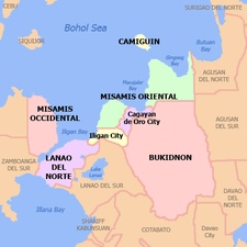
Located in Northern Mindanao, the province borders Bukidnon to the south, Agusan del Norte to the east and Lanao del Norte to the west. On the north is the Bohol Sea with the island-province of Camiguin just off its northern coast. Misamis Oriental occupies a total land area of 3,131.52 square kilometres (1,209.09 sq mi)[5]. When the independent city of Cagayan de Oro is included for geographical purposes, the province's land area is 3,544.32 square kilometres (1,368.47 sq mi).[5]
Misamis Oriental, as a coastal province, is dominated by two bays to the north; the Macajalar and the Gingoog.[3] The central portion of the province features several rivers originating from the highlands of Bukidnon, such as the Cagayan.
Administrative divisions
Misamis Oriental comprises 23 municipalities and 2 component cities, which are organized into two legislative districts and further subdivided into 424 barangays. The provincial capital, Cagayan de Oro, is a highly urbanized city that is administered independently from the province.
| |||||||||||||||||||||||||||||||||||||||||||||||||||||||||||||||||||||||||||||||||||||||||||||||||||||||||||||||||||||||||||||||||||||||||||||||||||||||||||||||||||||||||||||||||||||||||||||||||||||||||||||||||||||||||||||||||||||||||||||||||||||||||||||||||||||||||||||||||||||||||||||||||||||||||||||||||||||||||||||||||||||||||||||||||||||||||||||||||||||||||||||||||||||||||||||||
Demographics
| Population census of Misamis Oriental | ||
|---|---|---|
| Year | Pop. | ±% p.a. |
| 1990 | 525,453 | — |
| 1995 | 587,551 | +2.12% |
| 2000 | 664,338 | +2.67% |
| 2007 | 748,885 | +1.67% |
| 2010 | 813,856 | +3.07% |
| 2015 | 888,509 | +1.69% |
| (excluding Cagayan de Oro City) Source: Philippine Statistics Authority[2][6][6] | ||
The population of Misamis Oriental in the 2015 census was 888,509 people,[2] with a density of 280 inhabitants per square kilometre or 730 inhabitants per square mile. When Cagayan de Oro City is included for geographical purposes, the province's population is 1,564,459 people, with a density of 441/km2 (1,143/sq mi).
Language
Cebuano is primarily the spoken language of the province, including Cagayan de Oro, with the vast majority claiming it to be their mother tongue. Many are fluent in Tagalog as a secondary language and English, which is being mainly used for business and in the academe. Maranao is also spoken among the Maranao communities within the province.
Religion
Roman Catholicism predominates in the province with roughly 83% of the population. Many other Christian faiths compose most of the minority religions while Islam has a small but steadily increasing number.
Economy
The province is host to industries such as agricultural, forest, steel, metal, chemical, mineral, rubber and food processing. It is home to the 30 square kilometre PHIVIDEC Industrial Estate and the Mindanao International Container Port, all in Tagoloan. Del Monte Philippines, which exports pineapples all over the Asia-Pacific region, has a processing plant in Cagayan de Oro.
On January 10, 2008, Hanjin Heavy Industries and Construction Company of South Korea inked a contract to build a $2 billion shipyard building complex at Villanueva, Misamis Oriental with the PHIVIDEC Industrial Authority. It is bigger than Hanjin's $1 billion shipyard complex in Subic, Olongapo City which will hire 20,000 Filipinos to manufacture ship parts. The Philippine government declared the 441.8-hectare project site an economic zone (part of 3,000-hectare industrial estate managed by PHIVIDEC).[7]
Tourism
Misamis Oriental is home to many natural scenic spots.
This place in Brgy. Moog, Laguindingan, offers crystal clear water and fine gray sand. Its name is derived from the image of the Virgin Mary on its rockwall. In that spot, an altar has been built in honor of the Virgin Mary.
Located along the Provincial Road in Brgy. San Antonio, Jasaan, and Hermano, Balingasag (31 kilometres (19 mi) east of Cagayan de Oro), this beach has round, smooth stones that cover the beach front. The water is crystal clear even when viewed up the road. The Sangguniang Bayan Council of Balingasag proposes that it would be developed as a marine sanctuary if they would be given financial support by the local government.
Located along the highway in Brgy. Poblacion, Binuangan, this beach offers crystal clear water. A shrine is built in honor of the saint Bernadette Soubirous of Lourdes, France.
An undeveloped beach in Brgy. Poblacion, Binuangan (66 kilometres (41 mi) east of Cagayan de Oro), with fine white sand that is shaped like a cove with lush vegetation in the background.
A beach in Brgy. Mangga, Sugbongcogon (71 kilometres (44 mi) east of Cagayan de Oro), that has a fresh underwater spring and fine white sand.
Government
- Congressmen:
- 1st District of Misamis Oriental with Gingoog City: Peter M. Unabia (Liberal Party)
- 2nd District of Misamis Oriental with El Salvador City: Juliette T. Uy (Independent)
- Governor: Yevgeny Vicente B. Emano (Nacionalista Party)
- Vice-Governor: Joey G. Pelaez (United Nationalist Alliance)
|
|
List of former governors
- Manuel Roa Corrales — 1901-1905
- Apolinar Velez — 1906-1909
- Ricardo Reyes Barrientos — 1910-1912
- Jose Reyes Barrientos — 1912-1916
- Isidro Rillas — 1917-1919
- Juan Valdeconcha Roa — 1920-1922
- Segundo Gaston — 1923-1925
- Don Gregorio A. Pelaez — 1926-1931
- Gregorio Borromeo — 1935-1937
- Don Gregorio A. Pelaez — 1938-1940
- Pedro S.A Baculio — 1941-1945
- Mariano Ope Marbella — 1945
- Ignacio S. Cruz — 1946-1947
- Felicisimo E. Aguilar — 1948-1950
- Paciencio G. Ysalina — 1951-1954
- Vicente L. De Lara, Sr. — 1954-1961
- Alfonso R. Dadole — 1961-1967
- Pedro N. Roa — 1968-1969
- Concordio C. Diel — September 1969 - March 1974
- Rosauro P. Dongallo — March 1974 - December 1979
- Meynardo A. Tiro — January 1980 - March 2, 1980
- Homobono A. Adaza — March 3, 1980 - July 22, 1984
- Fernando B. Pacana, Jr - July 23, 1984 - March 2, 1986
- Vicente Y. Emano — March 3, 1986 - December 1987[1];
February 1, 1988 - February 2, 1998 - Norris C. Babiera[1] - December 1987 - February 1988
- Ruth de Lara-Guingona — February 2 - June 30, 1998
- Antonio P. Calingin — June 30, 1998 - December 15, 2003
- Miguel C. De Jesus[2] — December 15, 2003 - June 30, 2004
- Oscar S. Moreno — June 30, 2004 - June 30, 2013
- Yevgeny Vicente B. Emano — June 30, 2013 — present
- ^ Appointed
- 2none Acting Capacity
See also
References
- ↑ "List of Provinces". PSGC Interactive. Makati City, Philippines: National Statistical Coordination Board. Retrieved 25 June 2014.
- 1 2 3 4 "Region X (NORTHERN MINDANAO)". Census of Population (2015): Total Population by Province, City, Municipality and Barangay (Report). PSA. Retrieved 20 June 2016.
- 1 2 Lancion, Jr., Conrado M.; cartography by de Guzman, Rey (1995). "The Provinces; Misamis Oriental". Fast Facts about Philippine Provinces (The 2000 Millenium ed.). Makati, Metro Manila, Philippines: Tahanan Books. p. 106. ISBN 971-630-037-9. Retrieved 28 December 2015.
- ↑ http://www.gmanetwork.com/news/story/361383/scitech/science/200-000-year-old-fossilized-oysters-found-in-misamis-oriental
- 1 2 3 4 "Province: Misamis Oriental". PSGC Interactive. Quezon City, Philippines: Philippine Statistics Authority. Retrieved 8 January 2016.
- 1 2 3 "Region X (NORTHERN MINDANAO)". Census of Population and Housing (2010): Total Population by Province, City, Municipality and Barangay (Report). NSO. Retrieved 29 June 2016.
- ↑ www.manilastandardtoday.com, Hanjin builds $2-b shipyard in Mindanao
External links
-
 Media related to Misamis Oriental at Wikimedia Commons
 -
 Geographic data related to Misamis Oriental at OpenStreetMap
 - Official website of the Province of Misamis Oriental
- Philippine Standard Geographic Code
- Local Governance Performance Management System
 |
Bohol Sea, Camiguin | | ||
| Misamis Occidental / Iligan Bay | |
Agusan del Norte | ||
| ||||
| | ||||
| Lanao del Norte | Bukidnon | Agusan del Sur |
Cagayan de Oro (capital) | |
| Municipalities | |
| Component cities | |
| Highly urbanized city |
|