Lake Pinatubo
| Lake Pinatubo | |
|---|---|
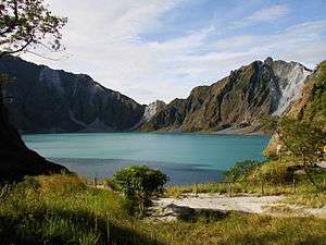 The crater lake, formed after the 1991 eruption of Mount Pinatubo | |
.svg.png) Lake Pinatubo Location within the Philippines | |
| Location | Mount Pinatubo, Luzon |
| Coordinates | 15°8′37″N 120°21′1″E / 15.14361°N 120.35028°ECoordinates: 15°8′37″N 120°21′1″E / 15.14361°N 120.35028°E |
| Type | crater lake |
| Primary inflows | Precipitation only |
| Primary outflows | Bucao River; other smaller rivers and creeks |
| Catchment area | 5 km2 (2 sq mi) |
| Basin countries | Philippines |
| Max. width | 2.5 km (1.6 mi)[1] |
| Surface area | 183 ha (450 acres) |
| Max. depth | 600 m (2,000 ft)[2] |
| Surface elevation | 900 m (3,000 ft) |
| Settlements | |
Lake Pinatubo (Filipino: Lawa ng Pinatubo) is the summit crater lake of Mount Pinatubo formed after its climactic eruption on June 15, 1991. The lake is located near the boundaries of Pampanga, Tarlac and Zambales provinces in the Philippines and is the deepest lake in the country at 600 m (2,000 ft). It is about 90 km (56 mi) northwest of the capital city of Manila.
Geology
Mount Pinatubo's volcanic activity has followed a cycle: centuries of repose terminated by a caldera-forming eruption with large pyroclastic flows; a post-eruption aftermath of rain-triggered lahars in surrounding drainages and dome-building that fills the caldera; and then another long quiescent period. During and after the eruptions, lahars descending along volcano channels may block tributaries from watersheds beyond Pinatubo, creating natural lakes.[3] Geophysical evidence shows that there were at least two ancient lakes in the Mapanuepe River valley in the southwestern part of the volcano.
Origin
The climactic 1991 eruption of Mount Pinatubo destroyed the volcano's original summit. In its place is a 2.5 kilometres (1.6 mi) diameter caldera, the center of which is offset 1 kilometre (0.62 mi) northward from the pre-eruption summit. It was created from the collapse of the volcano's summit on June 15, during the period of abundant large earthquakes in response to withdrawal of a large volume of magma from the reservoir beneath the volcano.[4] By early September 1991, a shallow lake formed. The high precipitation rate of the area led to a rapid transition from a small and hot acid lake to a large lake with near-ambient temperature and pH.[1][5]
Legend
The mountain range wherein the volcano is located is inhabited by the indigenous Aetas. An old Aeta legend tells of a lake that once existed in the site, most probably the latter of the two ancient crater lakes, and of a great explosion that destroyed it.
Lake drainage

Risk of flash floods in the communities found in the vicinity of the recently dormant volcano is imminent because of a danger of the caldera collapsing due to water pressure and a long-term increase in the water level of ~1 m/month. Experts had feared the weight of the water could have breached the crater walls and flooded the homes of up to 40,000 people in and around the small coastal town of Botolan, located 25 miles from the volcano.
In September 2001, residents of Botolan and nearby areas were sent to evacuation centers as a precaution from a possible deluge of mud and water. The Philippine government ordered a controlled draining of the lake and had authorities dig a 5m-wide channel from the edge of the volcano's crater, draining about a quarter of the lake's volume and diverting the excess lakewater into local rivers. Existing lahar canyons serve as water drainage paths to surrounding rivers and creeks, the largest of which is the Bucao River. In 2002, accumulated rainwater in the lake rose to dangerous levels during the rainy monsoon season, breached the artificial drainage canal, and triggered mild lahar flows in the area.[6]
- Lake Pinatubo and its Eroding Caldera
.jpg) Pinatubo Crater Lake, 2005
Pinatubo Crater Lake, 2005 The Pinatubo crater lake in January 2006
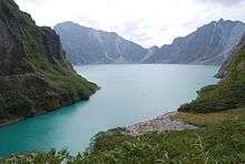 Lake Pinatubo, January 11, 2009
Tourism
The lake is described as "a wide jewel of blue and green" [7] and is now a popular bush walking destination, mostly frequented by mountaineers and adventure-seekers. Until a few years ago, a trip to the summit involved either days of hiking or hours of 4-wheel vehicle travel followed by a 2-hour hard hike. Eventually, a trail called the Skyway was made that allows 4 wheel drive vehicles a shorter route to a drop off point to trek to the crater. The skyway shortened the route to a 1.4-hour ride and a 45-minute to an hour's trek. The best time to visit the lake is during the dry season, from November to May.
See also
Notes
- 1 2 "Evolution of a Small Caldera Lake at Mount Pinatubo". USGS.gov. Retrieved on 2011-11-20.
- ↑ Yang, P.; Yokoyama, N.; Inoue, K.; Amina, K. (2005), "Preliminary investigation of the crater lake breach at Mt. Pinatubo, Philippines", Journal of the Japan Society of Engineering Geology, Japan Society of Engineering Geology, 46 (5): 288
- ↑ Journal of Volcanology and Geothermal Research Volume 176, Issue 3, 1 October 2008, Pages 432-437 Volcanoes and Human History (retrieved: 26 March 2009)
- ↑ Wolfe (1992). "The 1991 Eruptions of Mount Pinatubo, Philippines: Earthquakes and Volcanoes, v.23, no.1". (Retrieved: 10 March 2009)
- ↑ Bulletin of Volcanology, ISSN 0258-8900 (print), ISSN 1432-0819 (online); Issue: Vol. 66, No.2 /February 2004, pp.149-167 (retrieved: 10 March 2009)
- ↑ Asia Africa Intelligence Wire, Publication Date: 06-AUG-02 (retrieved: 12 March 2009)
- ↑ C. Tejero, PINATUBO 10 YEARS AFTER : Beyond the valley of lahar, Philippine Daily Inquirer, 2001-04-29 (retrieved: 10 March 2009)
References
- PHIVOLCS -Pinatubo Data Update (retrieved: 5 March 2009)
- Mount Pinatubo Trek (retrieved: 10 March 2009)
- BBC News Online (retrieved: 26 March 2009)
- Newhall, C.G. and Punongbayan, R.S., Fire and Mud: Eruptions and Lahars of Mount Pinatubo, Philippines, Philippine Institute of Volcanology and Seismology, Quezon City and University of Washington Press, Seattle and London, 1126 pages, 1996. (retrieved: 10 March 2009)
- BBC NEWS World: Asia-Pacific, Friday, 7 September 2001, 12:52 GMT 13:52 UK (retrieved: 10 March 2009)
- BBC NEWS World: Asia-Pacific, Friday, 7 September 2001, 21:25 GMT 22:25 UK (retrieved: 12 March 2009)
External links
- Geographic data related to Lake Pinatubo at OpenStreetMap