Ortigas Center
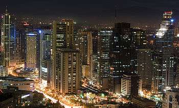
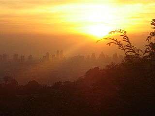
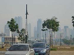
Ortigas Center is a financial and central business district located at the boundaries of Pasig, Mandaluyong, and Quezon City in the Philippines. With an area of more than 100 hectares (250 acres), it is Metro Manila's second most important business district after the Makati CBD.[1] It is governed by Ortigas Center Association, Inc.
Ortigas Center is home to many shopping malls, office and condominium skyscrapers, other building complexes, nightlife bars and restaurants. These include the St. Francis Square, the Asian Development Bank compound, the Oakwood Premier serviced apartments and a Shangri-La hotel. It is also the headquarters of San Miguel Corporation, Jollibee Foods Corporation, the Philippine branch of HSBC, and Robinsons Galleria. Also present in the area are Philippine offices of prominent engineering firms such as Parsons Brinckerhoff, Sinclair Knight Merz, and WSP Group. It also home to the Banco de Oro main office owned by mall taipan Henry Sy, Sr. SM Megamall, the third largest mall in the world and the largest in the country, is also in the Center along EDSA, as is The Medical City, one of the three hospitals in the country accredited by the Joint Commission on International Accreditation.[2]
Ortigas Center is surrounded by the streets of EDSA to the west, Ortigas Avenue to the north, Meralco Avenue to the east, and Shaw Boulevard to the south.
History
Ortigas Center began as the 4,033-hectare "Hacienda de Mandaloyon", an estate from the Augustinian Order. In the following years, there were several changes of partners. Then, on July 10, 1931, the company was incorporated “Ortigas, Madrigal y cia., S. en C.” as a limited partnership by shares (sociedad comanditaria por acciones). The parties to the partnership were Francisco Ortigas (Don Paco), Vicente Madrigal, B.C.M. Johnston, Fulgencio Borromeo, Clyde A. Dewitt and Manuel L. Quezon.
When Ortigas & Company acquired the estate, it was a virtual wasteland. The vision of the management, headed by Atty. Francisco Ortigas, Jr., who was President and Chairman at that time, turned it into a progressive industrial, commercial, and residential urban complex.[3]
Districts
North Side
The northern portion of the area is part of Quezon City. It is situated south of Ugong Norte. The EDSA Shrine and Robinsons Galleria is situated here. Robinsons Galleria is a mixed-use complex composed of two high-rise office towers namely the Galleria Corporate Center and the Robinsons-Equitable Tower, the Holiday Inn Manila and Crowne Plaza Manila, the Galleria Regency and a 5-level shopping mall. Before Robinsons Galleria, This mall used to be an open land owned by SSS at Ortigas CBD. In 1986, they used the land for the People Power Revolution. In 1987, John Gokongwei bought the large portion of the land from SSS. It started construction on mid-1988 and finished on late-1989. The mall opened in 1990 being the first mall of Robinsons Malls.
West Side
The western portion of Ortigas Center is part of Mandaluyong City. It is in the eastern side of Barangay Wack-Wack Greenhills. Mandaluyong is known for being the "Shopping Capital of the Philippines" because it is home to a cluster of shopping centers which stand side by side. This is where most of the shopping malls in the area located like SM Megamall, The Podium, Shangri-la Plaza Mall and St. Francis Square Mall. It is also proximity to nearby Cybergate Center.
East Side
The eastern portion of Ortigas Center is part of Pasig. The whole place is politically known as Barangay San Antonio. It is where most of Pasig's financial resources are primarily concentrated. This is where most of skyscrapers of Ortigas Center located. The barangay of San Antonio has the largest income in Pasig, second only to San Lorenzo Village of Makati as the largest single income-generated government unit in the Philippines.
Prominent Structures
Buildings
- Integrated Bar of the Philippines Building
- Parc Royale Condominium
- The Taipan Place
- One San Miguel Avenue Building
- Pacific Center Bldg.
- UnionBank Plaza
- Orient Square Building
- The St. Francis Shangri-La Place
- Edsa Shangri-la Hotel, Manila
- Philippine Stock Exchange Centre (Tektite Towers)
- Hanston Square Bldg.
- OMM-Citra Building
- Raffles Corporate Center
- Wynsum Corporate Tower
- Prestige Tower Building
- Tycoon Center
- Jollibee Plaza
- Cityland Plaza
- Strata 100
- Strata 2000
- Robinsons Equitable Tower
- One Corporate Centre
- Amberland Plaza
- 8137 Plaza
- Antel Global Corporate Center
- Discovery Suites
- OCAI Building
- JMT Corporate Condominium
- Benpres Building
- The Centerpoint Building
- Medical Plaza Ortigas Building
- East of Galleria
- Goldland Millenia Tower
- Grand Emerald Tower
- St. Francis Square
- Joy-Nostalg Center
- Octagon
- Robinsons Cyberscape Alpha
- Robinsons Cyberscape Beta
- Metrowalk
- Marco Polo Hotel
- Banco De Oro Corporate Center Ortigas
- SM Group of Companies Mega Tower ( Under Construction)
Malls
- SM Megamall
- Shangri-La Plaza
- Star Mall Ortigas
- St. Francis Square Mall
- Robinsons Galleria
- The Podium
Offices
- Banco De Oro (BDO)
- Monroe Multinational Group, Inc.
- Times Core International Inc.
- Startek International Ltd.
- Snyffy Co
- Emerson Electric Asia
- Fisher-Rosemount Systems, Inc. (Emerson Process Management, Phils.)
- Asian Development Bank
- Starmall, Inc.
- SEAOIL Philippines, Inc.
- Parsons Brinckerhoff Philippines, Inc.
- Sinclair Knight Merz Philippines, Inc.
- WSP Philippines (Asia)
- Oakwood Premier Joy~Nostalg Center
- San Miguel Corporation
- Jollibee Foods Corporation
- HSBC
- Fujitsu Ten Solutions Philippines Inc
- Hewlett-Packard Philippines
- dotPH
- Chikka Asia, Inc.
- Ideal Minds Corporation
- Union Bank
- Energy Regulatory Commission
- Grupo Sorbetero
- Mega Publishing
- Mobile920 Software Development
- Summit Media
- Viva Entertainment
- Regal Entertainment
- INC Navigation Company Philippines Inc.
- Software Ventures International
- Pacific Internet, Philippines
- SkyCable Corporation
- Star TV
- Sonshine Media Network International
- ZOE Broadcasting Network
- Fox International Channels (Philippines)
- Tsukiden Global Solutions, Inc
- Broadcast Enterprises and Affiliated Media, Inc.
- Ultrasonic Broadcasting System
- Health Plan Philippines, Inc.
- 247 inc.
- DBSOFT Philippines INC.
- GlobalSky Communication
- TRG Philippines
- Sitel Philippines
- Telus Philippines
- Trec Pacific
- Teleperformance
- Transcom Worldwide
- Havenlink
- Sykes Enterprises
- Branders.com
- Convergys
- Concentrix
- BlastAsia
- Sterling Global Call Center
- Alorica Philippines, Inc.
- Pacific Hub
- Cyberbase Solutions Inc.
- A & E Global fusion
- Cziers Global Solutions Co.
- Asia Teleservices Inc
Churches
- Our Lady of Peace - EDSA Shrine
- Saint Francis of Assisi Church
- Chapel of the Eucharistic Lord, SM Megamall
- Stella Orientis Oratory, University of Asia and the Pacific
- Christ's Commission Fellowship
- Victory Christian Fellowship
- Members Church of God International
- Greenhills Christian Fellowship
- Mu Gyung (Korean) Baptist Church
- Sumbogum Manila (Korean) Full Gospel Church
- Bread from Heaven Community Church
- Hope Christian Fellowship (BGC)
- River of God Church
- Harvesters Christian Fellowship, Unionbank Plaza
Schools
TV and radio studios Transmitters
- Southern Broadcasting Network (ETC)
- ZOE Broadcasting Network
- 90.7 Love Radio
- 101.1 Yes! FM
- Monster Radio RX 93.1
- 96.3 Easy Rock
- 106.7 Energy FM
- 102.7 Star FM
- 702 DZAS AM
References
External links
- Ortigas & Company Limited Partnership - Ortigas & Company Limited Partnership Corporate Website
| Towers |
|  | |||||
|---|---|---|---|---|---|---|---|
| Shopping centers | |||||||
| Other landmarks | |||||||
| Education | |||||||
| Transportation |
| ||||||
Italics denote buildings under construction or planned. | |||||||
Cities and municipalities | |||||||||||||||||||
| |||||||||||||||||||
| |||||||||||||||||||
See also: Administrative divisions of Metro Manila | |||||||||||||||||||
Coordinates: 14°35′00″N 121°03′40″E / 14.58333°N 121.06111°E