Apayao
| Apayao | ||
|---|---|---|
| Province | ||
| Province of Apayao | ||
| ||
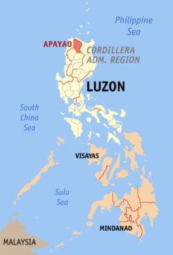 Location in the Philippines | ||
| Coordinates: 17°45′N 121°15′E / 17.75°N 121.25°ECoordinates: 17°45′N 121°15′E / 17.75°N 121.25°E | ||
| Country | Philippines | |
| Region | Cordillera Administrative Region (CAR) | |
| Founded | February 14, 1995 | |
| Capital | Kabugao* | |
| Government | ||
| • Type | Sangguniang Panlalawigan | |
| • Governor | Elias C. Bulut, Jr. (Liberal Party) | |
| • Congresswoman | Eleanor C. Bulut-Begtang (Nationalist People's Coalition) | |
| • Vice Governor | Hector Pascua (Liberal Party) | |
| Area[1] | ||
| • Total | 4,413.35 km2 (1,704.00 sq mi) | |
| Area rank | 27th out of 81 | |
| Population (2015 census)[2] | ||
| • Total | 119,184 | |
| • Rank | 78th out of 81 | |
| • Density | 27/km2 (70/sq mi) | |
| • Density rank | 81st out of 81 | |
| Divisions | ||
| • Independent cities | 0 | |
| • Component cities | 0 | |
| • Municipalities |
7
| |
| • Barangays | 133 | |
| • Districts | Lone district of Apayao | |
| Time zone | PHT (UTC+8) | |
| ZIP code | 3807–3814 | |
| IDD : area code | +63 (0)74 | |
| ISO 3166 code | PH-APA | |
| Spoken languages | ||
| Website |
www | |
| * Kabugao is the officially-recognized capital and seat of government, although the province carries out many of its operations in a new government center established in Luna. | ||

Apayao (Ilocano: Probinsya ti Apayao, Filipino: Lalawigan ng Apayao) is a landlocked province in the Philippines in the Cordillera Administrative Region in Luzon. Its capital town is Kabugao.
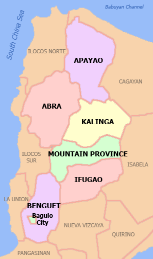
The province borders Cagayan to the north and east, Abra and Ilocos Norte to the west, and Kalinga to the south. Prior to 1995, Kalinga and Apayao comprised a single province named Kalinga-Apayao, which was partitioned to better service the needs of individual ethnic groups.
With a population of 119,184 (as of the 2015 census)[2] covering an area of 4,413.35 square kilometres (1,704.00 sq mi),[1] Apayao is the least densely-populated province in the Philippines.
History
Spanish period
Although Apayao, which was then part of Cagayan,[3] was among the earliest areas penetrated by the Spaniards in the Cordilleras, the region, inhabited by the Isneg tribe, remained largely outside Spanish control until late in the 19th century. As early as 1610, the Dominican friars established a mission in what is now the town of Pudtol. In 1684, the friars again made attempts to convert the people and established a church in what is now Kabugao.

The Spanish authorities were then able to establish in Cagayan the comandancias of Apayao and Cabugaoan in 1891,[3][4][5] which covered the western and eastern portions of what is now Apayao. The comandancias, however, failed to bring total control and the Spanish government only maintained a loose hold over the area.
American period
The Americans established the Mountain Province on August 13, 1908, with the enactment of Act No. 1876. Apayao, along with Amburayan, Benguet, Bontoc, Ifugao, Kalinga, and Lepanto, became sub-provinces of this new province.[4][5][6]
World War II
In 1942, Japanese Imperial forces entered Apayao, starting a three-year occupation of the province during the Second World War. Local Filipino troops of the 1st, 2nd, 12th, 15th and 16th Infantry Division of the Philippine Commonwealth Army and the military forces of the USAFIP-NL 11th and 66th Infantry Regiment, supported by the Cordilleran guerrillas, drove out the Japanese in 1945.
Kalinga-Apayao creation and splitting
On June 18, 1966, the huge Mountain Province was split into four provinces with the enactment of Republic Act No. 4695. The four provinces were Benguet, Bontoc (renamed "Mountain Province"), Kalinga-Apayao and Ifugao.[5][7] Kalinga-Apayao, along with Ifugao, became one of the provinces of the Cagayan Valley region in 1972.[7]
On July 15, 1987, the Cordillera Administrative Region was established and Kalinga-Apayao was made one of its provinces.[5][7][8][9]
Finally, on February 14, 1995, Kalinga-Apayao was split into two independent provinces with the passage of Republic Act No. 7878.[5][7][10]
Geography
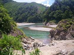
Apayao is basically situated within the Cordillera Central mountains, traversed by many rivers. The province covers an area of 4,413.35 square kilometres (1,704.00 sq mi)[11] forming the northern tip of the Cordillera Administrative Region, and is bounded on the north and east by Cagayan, west by Ilocos Norte, southwest by Abra and south by Kalinga.
Plains and valleys are used for farming. Apayao is basically composed of farmlands.
Climate
The prevailing climate in the province falls under Corona's Type III Classification. It is characterized by relatively dry and wet seasons, from November to April, and wet during the rest of the year. Heaviest rain occurs during December to February while the month of May is the warmest.
Administrative divisions
Apayao comprises 7 municipalities, all encompassed by a lone legislative district.[11]
|
 | |||||||||||||||||||||||||||||||||||||||||||||||||||||||||||||||||||||||||||||||||||||||||||||||||||||||||||||||||||||||||||||||||||||||||||||||||
Barangays
The 7 municipalities of the province comprise a total of 133 barangays, with Barangay Malama in Conner as the most populous in 2015, and Eleazar in Calanasan as the least.[12][11]
Demographics
The population of Apayao in the 2015 census was 119,184 people,[12] with a density of 27 inhabitants per square kilometre or 70 inhabitants per square mile.
|
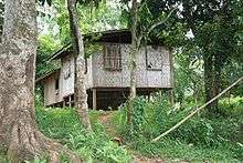 Native Dibagat homes | ||||||||||||||||||||||||||||
Based on the 2000 census survey, Ilocanos comprised 49,328 (50.82%) of the total provincial population of 97,058, while almost 1/3 of the population were Isnag at 29,071 (29.95%). Other ethnic groups in the province were the Malaueg at 3,580 (3.69%), Isneg at 3,380 (3.48%), Kalinga at 2,992 (3.08%), Kankanaey at 1,208 (1.24%), Bontoc at 1,014 (1.04%), and Ibaloi at 979 (1.01%).[15]
Economy
Apayao is devoted to agricultural production, particularly food and industrial crops such as palay,[16] corn,[17] coffee, root crops and vegetables. Fruits produced include lanzones, citrus, bananas and pineapples, durian, santol, rambutan, coconut and mangosteen.[18] Rice production totaled 98,489 metric tons in 2011.[16]
Economic activity is also based on livestock and poultry breeding such as swine, carabao, cattle, goat and sheep. Other additional investment includes manufacturing, food processing, furniture, crafts and house wares making.[19]
Updated records of the Department of Trade and Industry Provincial Office reveal that existing industries in the province are furniture, garment craft, food processing, gifts and house wares, and agricultural support.
References
- 1 2 "List of Provinces". PSGC Interactive. Makati City, Philippines: National Statistical Coordination Board. Archived from the original on 21 January 2013. Retrieved 2 January 2014.
- 1 2 3 Census of Population (2015): Highlights of the Philippine Population 2015 Census of Population (Report). PSA. Retrieved 20 June 2016.
- 1 2 "History". Province of Cagayan (Official Website of the Provincial Government of Cagayan). Retrieved 18 January 2015.
- 1 2 "Benguet History". Province of Benguet (official website). Retrieved 1 January 2015.
- 1 2 3 4 5 "Historical Background". Provincial Government of Apayao (official website). Retrieved 18 January 2015.
- ↑ Ingles, Raul Rafael (2008). 1908 :The Way it Really was : Historical Journal for the UP Centennial, 1908-2008. Diliman, Quezon City: University of the Philippines Press. p. 330. ISBN 9715425801. Retrieved 19 January 2015.
- 1 2 3 4 Lancion, Jr., Conrado M.; de Guzman, Rey (cartography) (1995). "The Provinces". Fast Facts about Philippine Provinces (The 2000 Millenium ed.). Makati, Metro Manila: Tahanan Books. pp. 76, 86, 108. ISBN 971-630-037-9. Retrieved 16 January 2015.
- ↑ "Regional Profile: Cordillera Administrative Region (CAR)". CountrySTAT Philippines. Retrieved 18 September 2014.
- ↑ "The Cordillera Administrative Region (CAR)". Department of Agriculture. Retrieved 18 September 2014.
- ↑ "Republic Act No. 7878 - An Act Converting the Sub-provinces of Kalinga and Apayao into Regular Provinces to be Known as the Province of Kalinga and the Province of Apayao, Amending for the Purpose Republic Act No. 4695". Chan Robles Virtual Law Library. Retrieved 18 January 2015.
- 1 2 3 4 "Province: Apayao". PSA. Philippines: National Statistical Coordination Board. Retrieved 8 January 2016.
- 1 2 3 "CORDILLERA ADMINISTRATIVE REGION (CAR)". Census of Population (2015): Total Population by Province, City, Municipality and Barangay (Report). PSA. Retrieved 20 June 2016.
- ↑ "CORDILLERA ADMINISTRATIVE REGION (CAR)". Census of Population and Housing (2010): Total Population by Province, City, Municipality and Barangay (Report). NSO. Retrieved 29 June 2016.
- ↑ Census of Population and Housing (2010): Population and Annual Growth Rates for The Philippines and Its Regions, Provinces, and Highly Urbanized Cities (PDF) (Report). NSO. Retrieved 29 June 2016.
- 1 2 "Apayao: Three Out of Five Academic Degree Holders Were Females; Table 4. Household Population by Ethnicity and Sex: Apayao, 2000". National Statistics Office. 12 July 2002. Archived from the original on 9 June 2006. Retrieved 17 December 2015.
- 1 2 "DA allots P278M for irrigation, agri projects in Apayao". Official Gazette of the Republic of the Philippines. Department of Agriculture. 15 June 2012. Retrieved 23 April 2016.
Last year, Apayao produced a total of 98,489 metric tons of palay (paddy rice), according to the DA’s Bureau of Agricultural Statistics. The volume is equivalent to 64,017 MT of rice at 65 percent milling recovery.
- ↑ Vanzi, Sol Jose (28 April 1998). "Apayao Secret: Drought-Resistant Corn". Newsflash.Org. Retrieved 23 April 2016.
- ↑ Galvez, James Konstantin (14 January 2014). "Government agri program to promote Apayao's wild fruits". The Manila Times. Retrieved 23 April 2016.
The province of Apayao is host to some of the country’s indigenous crops including: lubeg, bignay, bignay kalabaw, calumpit, saging matsing, other than the fruit-bearing trees like durian, marang, lanzones, rambutan, pineapple, mangosteen, coconut, santol, among others.
- ↑ "Apayao producers open new markets in cities". Philippine Information Agency. 5 December 2009. Retrieved 23 April 2016.
External links
-
 Media related to Apayao at Wikimedia Commons
 -
 Geographic data related to Apayao at OpenStreetMap
 |
Cagayan | | ||
| Ilocos Norte | |
Cagayan | ||
| ||||
| | ||||
| Abra | Kalinga |