Pangasinan


Pangasinan (Pangasinan: Luyag na Pangasinan; Filipino: Lalawigan ng Pangasinan) is a province in the Philippines. Its official language is Pangasinan and its provincial capital is Lingayen. Pangasinan is located on the western area of the island of Luzon along the Lingayen Gulf and South China Sea. It has a total land area of 5,451.01 square kilometres (2,104.65 sq mi).[1] According to the 2015 census, it has a population of 2,956,726 people.[2] The official number of registered voters in Pangasinan is 1,651,814.[3]
Pangasinan is the name for the province, the people, and the official language spoken in the province. Indigenous Pangasinan speakers are estimated to number at least 2 million. The Pangasinan language is one of the officially recognized regional languages in the Philippines. In Pangasinan, there were several ethnic groups who enriched the cultural fabric of the province. Almost all of the people are Pangasinenses and the rest are descendants of Bolinao and Ilocano, who settled the eastern and western parts of the province.[4] Pangasinan is also spoken as a second-language by many of the ethnic minorities in Pangasinan. The minority ethnic groups are the Bolinaos and the Ilocanos.
The name Pangasinan pronounced as "Pang-gASINan" It means "place for salt" or "place of salt-making"; it is derived from the prefix pang, meaning "for", the root word asin, meaning "salt”, and suffix an, signifying "location". At present it is pronounced Paŋgasinan based on the Spanish pronunciation due to their inability to utter or pronounce the nasal sound <nga> /ŋ/. The province is a major producer of salt in the Philippines. Its major products include "bagoong" ("salted-fish") and "aramang" ("salted-shrimp")
Pangasinan was founded by Austronesian speakers who called themselves Anakbanwa by at least 2500 BC. A kingdom called Luyag na Kaboloan, which expanded to incorporate much of northwestern Luzon, existed in Pangasinan before the Spanish conquest that began in the 16th century.[5] The Kingdom of Loyag na Kaboloan was known as the Huangdom of Pangasinan in Chinese records. The ancient Pangasinan people were skilled navigators and the maritime trade network that once flourished in ancient Southeast Asia connected Pangasinan with other peoples of Southeast Asia, India, China, and the Pacific. The ancient kingdom of Luyag na Kaboloan was in fact mentioned in Chinese and Indian records as being an important kingdom on ancient trade routes.[5]
Popular tourist attractions in Pangasinan include the Hundred Islands National Park in Alaminos City and the white-sand beaches of Bolinao and Dasol. Dagupan City is known for its Bangus Festival ("Milkfish Festival"). Pangasinan is also known for its delicious mangoes and ceramic oven-baked Calasiao puto ("native rice cake"). Pangasinan occupies a strategic geo-political position in the central plain of Luzon, known as the rice granary of the Philippines. Pangasinan has been described as a gateway to northern Luzon and as the heartland of the Philippines.
History
Ancient history
The Pangasinan people, like most of the people in the Malay Archipelago, are descendants of the Austronesian-speakers who settled in Southeast Asia since prehistoric times. Comparative genetics, linguistics and archaeological studies locate the origin of the Austronesian languages in Sundaland, which was populated as early as 50,000 years ago by modern humans.[6][7][8] The Pangasinan language is one of many languages that belongs to the Malayo-Polynesian languages branch of the Austronesian languages family.
Southeast Asian maritime trade network
A vast maritime trade network connected the distant Austronesian settlements in Southeast Asia, the Pacific and the Indian Ocean. The Pangasinan people were part of this ancient Austronesian civilization.
The ancient Austronesian-speakers were expert navigators. Their outrigger canoes and sailboats were capable of crossing the distant seas. The Malagasy sailed from the Malay archipelago to Madagascar, an island across the Indian Ocean, and probably reached Africa. The Polynesians settled the distant Pacific islands as far away as Hawaii and Easter Island and probably reached the Pacific coastline of the Americas. At least three hundred years before the arrival of Europeans, the Makasar and the Bugis from Sulawesi, in what is now Indonesia, as well as the Sama-Bajaus of the Malay Archipelago, carried out long-distance commerce with their prau or paraw ("sailboat") and established settlements in north Australia, which they called Marege.[9]
Pangasinan was founded by Austronesian peoples who called themselves Anakbanwa during the Austronesian expansion from Taiwan and Southern China in about 5000 - 2500 BC or the Austronesian dispersal from Sundaland at least 7,000 years ago after the last Ice Age. Anakbanwa means “child of banwa.” Banwa (also spelled banua or vanua) is an Austronesian concept that could mean territory, homeland, habitat, society, civilization or cosmos. The Pangasinan people identified or associated banwa with the sun, which was their symbol for their banwa. The Pangasinan people are closely related to the Ibaloi in the neighboring province of Benguet and other peoples of Luzon. The Anakbanwa established their settlements in the banks of the Agno River and the coasts of Lingayen Gulf. The coastal area came to be known as Pangasinan, and the interior area came to be known as Kaboloan. Eventually, the whole region, its people and the used language came to be known as Pangasinan. Archaeological evidence and early Chinese and Indian records show that the inhabitants of Pangasinan traded with India, Arabia, China and Japan as early as the 8th century A.D.
Huangdom of Pangasinan (Luyag na Kaboloan)
The Huangdom of Pangasinan (As known in Chinese records) and locally known as the ancient kingdom or state called Luyag na Kaboloan (also spelled Caboloan), with Binalatongan as its capital, existed in the fertile Agno River valley. Around the same period, the Srivijaya and Majapahit empires arose in Indonesia that extended their influence to much of the Malay Archipelago. Urduja/Udaya, a legendary woman warrior, is believed to have ruled in Pangasinan around the 14th century. The Luyag na Kaboloan expanded the territory and influence of Pangasinan to what are now the neighboring provinces of Tarlac, La Union, Zambales, Nueva Ecija and Benguet. Pangasinan enjoyed full independence until the Spanish conquest.
Anito and mana beliefs and practices
The ancient Pangasinan people, like other Austronesian peoples, practiced anito-worship. An anito was believed to be the spirit or divine power of an ancestor or the god or divine power in nature or natural phenomena. They believed in mana, an Austronesian concept which can be described as the divine power or vital or spiritual essence of every being and everything that exists. To the Pangasinan people, mana can be transferred, inherited or acquired, like from an ancestor, nature, or natural phenomena. Their belief or practice is similar to Shamanist or animist beliefs and rituals. They worshipped a pantheon of anito ("spirit" or "deity"). Their temples or altars were dedicated to a chief anito called Ama Kaoley (“Supreme Father”), who communicated through mediums or priests called manag-anito. These manag-anito wore special costumes when serving an anito and they made offerings of oils, ointments, essences, and perfumes in exquisite vessels.
Spanish accounts of pre-Hispanic Pangasinan
In the sixteenth-century Pangasinan was called the "Port of Japan" by the Spanish. The locals wore native apparel typical of other maritime Southeast Asian ethnic groups in addition to Japanese and Chinese silks. Even common people were clad in Chinese and Japanese cotton garments. They also blackened their teeth and were disgusted by the white teeth of foreigners, which were likened to that of animals. Also, used porcelain jars typical of Japanese and Chinese households. Japanese-style gunpowder weapons were also encountered in naval battles in the area.[10] In exchange for these goods, traders from all over Asia would come to trade primarily for gold and slaves, but also for deerskins, civet and other local products. Other than a notably more extensive trade network with Japan and China, they were culturally similar to other Luzon groups to the south.
Pangasinans were also described as a warlike people who were long known for their resistance to Spanish conquest. Bishop Domingo Salazar described them as really the worst people, the fiercest and cruelest in the land. There was evidence of Christian influence even before Spanish colonization; they used vintage wine in small quantities for their sacramental practices. The church bragged that they won the northern part of the Philippines for Spain not Spanish military. They were also unusually strict against adulterers, with the punishment being death for both offending parties. Pangasinans were also known to take defeated Zambal and Negrito warriors to sell as slaves to Chinese traders.[11]
Christianity
In 1324, Odoric of Pordenone, a Franciscan missionary from Friuli, Italy, is believed by some to have celebrated a Catholic Mass and baptized natives at Bolinao, Pangasinan. In July 2007, memorial markers were set up in Bolinao to commemorate Odoric's journey based on a publication by Luigi Malamocco, an Italian priest from Friuli, Italy, who claimed that Odoric of Perdenone held the first Catholic Mass in the Philippines in Bolinao, Pangasinan. That 1324 mass would have predated the mass held in 1521 by Ferdinand Magellan, which is generally regarded as the first mass in the Philippines, by some 197 years. However, historian William Henry Scott concluded after examining Oderic's writings about his travels that he likely never set foot on Philippine soil and, if he did, there is no reason to think that he celebrated mass.[12]
Spanish colonization
On April 27, 1565, the Spanish conquistador Miguel López de Legazpi arrived in the Philippine islands with about 500 soldiers to establish a Spanish settlement and begin the conquest of the archipelago. On May 24, 1570, the Spanish forces defeated Rajah Sulayman and other rulers of Manila and later declared Manila as the new capital of the Spanish East Indies. After securing Manila, the Spanish forces continued to conquer the rest of the island of Luzon, including Pangasinan.
Provincia de Pangasinan
In 1571, the Spanish conquest of Pangasinan began with an expedition by the Spanish conquistador Martín de Goiti, who came from the Spanish settlement in Manila through Pampanga. About a year later, another Spanish conquistador, Juan de Salcedo, sailed to Lingayen Gulf and landed at the mouth of the Agno River. Limahong, a Chinese pirate, fled to Pangasinan after his fleet was driven away from Manila in 1574. Limahong failed to establish a colony in Pangasinan, as an army led by Juan de Salcedo chased him out of Pangasinan after a seven-month siege.
The province of Pangasinan dates its actual beginnings as an administrative and judicial district, with Lingayen as the capital, to as early as 1580, but its territorial boundaries were first delineated in 1611. Lingayen has remained the capital of the province except for a brief period during the revolutionary Era when San Carlos served as temporary administrative headquarters, and during the slightly longer Japanese Occupation when Dagupan was the capital.[13]
The province of Pangasinan was formerly classified as an alcaldia mayor de termino, or first class civil province, during the Spanish regime and has, in fact, remained a first class-A province up to the present. Its territorial jurisdiction once included the entire province of Zambales and portions of what are now Tarlac and La Union provinces.[13]
Rebellion against the Spanish rule
Malong liberation
Andres Malong, a native chief of the town of Binalatongan (now named San Carlos City), liberated the province from Spanish rule in December 1660. The people of Pangasinan proclaimed Andres Malong Ari na Pangasinan ("King of Pangasinan"). Pangasinan armies attempted to liberate the neighboring provinces of Pampanga and Ilocos, but were repelled by a Spanish-led coalition of loyalist tribal warriors and mercenaries. In February 1661, the newly independent Kingdom of Pangasinan fell to the Spanish.
Palaris liberation
On November 3, 1762, the people of Pangasinan proclaimed independence from Spain after a rebellion led by Juan de la Cruz Palaris overthrew Spanish rule in Pangasinan. The Pangasinan revolt was sparked by news of the fall of Manila to the British on October 6, 1762. However, after the Treaty of Paris on March 1, 1763 that closed the Seven Years' War between Britain, France and Spain, the Spanish colonial forces made a counter-attack. On January 16, 1765, Juan de la Cruz Palaris was captured and Pangasinan independence was again lost.
Philippine revolution against Spain
The Katipunan, a nationalist secret society, was founded on July 7, 1892 with the aim of uniting the peoples of the Philippines and fighting for independence and religious freedom. The Philippine Revolution began on August 26, 1896 and was led by Andres Bonifacio, the leader of the Katipunan. On November 18, 1897, a Katipunan council was formed in western Pangasinan with Roman Manalang as Presidente Generalisimo and Mauro Ortiz as General. General Emilio Aguinaldo proclaimed Philippine independence on June 12, 1898. Dagupan City, the major commercial center of Pangasinan, was surrounded by Katipunan forces by July 18, 1898. The Battle of Dagupan lasted from July 18 to July 23 of that year with the surrender of 1,500 soldiers of the Spanish forces under Commander Federico J. Ceballos and Governor Joaquin de Orengochea.

The Battle of Dagupan, fought fiercely by local Katipuneros under the overall command of General Francisco Makabulos, chief of the Central and Directive Committee of Central and Northern Luzon, and the last remnants of the once mighty Spanish Army under General Francisco Ceballos, led to the liberation of Pangasinan from the Spaniards. The five-day battle was joined by three local heroes: Don Daniel Maramba from Santa Barbara, Don Vicente Prado from San Jacinto and Don Juan Quezada from Dagupan. Their armies massed in Dagupan to lay siege on the Spanish forces, making a last stand at the brick-walled Catholic Church.


Maramba led the liberation of the town of Santa Barbara on March 7, 1898 following a signal for simultaneous attack from Makabulos. Hearing that Santa Barbara fell into rebel hands, the Spanish forces in Dagupan attempted to retake the town, but were repulsed by Maramba's forces. Thus, after the setback, the Spaniards decided to concentrate their forces in Lingayen to protect the provincial capital. This enabled Maramba to expand his operations to Malasiqui, Urdaneta and Mapandan, taking them one after the other. He took one more town, Mangaldan, before proceeding to Dagupan to lay siege on the last Spanish garrison. Also on March 7, 1898, the rebels under the command of Prado and Quesada attacked convents in a number of towns in Zambales province, located west of Lingayen, which now constitute the western parts of Pangasinan.
Attacked and brought under Filipino control were Alaminos, Agno, Anda, Alos, Bani, Balincaguin, Bolinao, Dasol, Eguia and Potot. The revolt then spread to Labrador, Sual, Salasa and many other towns in the west. The towns of Sual, Labrador, Lingayen, Salasa and Bayambang were occupied first by the forces of Prado and Quesada before they proceeded to attack Dagupan.
At an assembly convened to organize a central governing body for Central and Northern Luzon on April 17, 1898, General Makabulos appointed Prado as politico-military governor of Pangasinan, with Quesada as his second in command. His appointment came a few days before the return of General Emilio Aguinaldo in May 1898 from his exile in Hong Kong following the signing of the Pact of Biac-na-Bato in December 1897. Aguinaldo's return gave fresh impetus to the renewal of the flame of the revolution. Thus, on June 3, 1898, General Makabulos entered Tarlac and from that day on, the fires of revolution spread.
So successful were the Filipinos in their many pitched battles against the Spaniards that on June 30, 1898, Spanish authorities decided to evacuate all their forces to Dagupan where a last stand against the rebels was to be made. Also ordered to go to Dagupan were all civilian and military personnel, including members of the volunteer locales of towns not yet in rebel hands. Those who heeded this order were the volunteer forces of Mangaldan, San Jacinto, Pozorrubio, Manaoag, and Villasis. Among those brought to Dagupan was the image of the Most Holy Rosary of the Virgin of Manaoag, which at that time was already the patron saint of Pangasinan.
When the forces of Maramba from the east and Prado from the west converged in Dagupan on July 18, 1898, the siege began. The arrival of General Makabulos strengthened the rebel forces until the Spaniards, holed up inside the Catholic Church, waved the flag of surrender five days later. Armed poorly, the Filipinos were no match at the very start with Spanish soldiers holed inside the Church. They just became mere sitting ducks to Spanish soldiers shooting with their rifles from a distance. But the tempo of battle changed when the attackers, under Don Vicente Prado, devised a crude means of protection to shield them from Spanish fire while advancing. This happened when they rolled trunks of bananas, bundled up in sawali, that enabled them to inch their way to the Church.
American colonization and the Philippine Commonwealth regime
Pangasinan and other parts of the Spanish East Indies were ceded to the Americans after the Treaty of Paris that closed the Spanish–American War. During the Philippine–American War, Lieutenant Col. Jose Torres Bugallon from the town of Salasa fought together with Gen. Antonio Luna to defend the First Philippine Republic against American colonization of Northern Luzon. Bugallon was killed in battle on February 5, 1899. The First Philippine Republic was abolished in 1901. In 1907, the Philippine Assembly was established and for the first time, five residents of Pangasinan were elected as its district representatives. In 1921, Mauro Navarro, representing Pangasinan in the Philippine Assembly, sponsored a law to rename the town of Salasa to Bugallon in order to honor General Bugallon.
During the Philippine Commonwealth regime, Manuel L. Quezon was inaugurated as the first president of the Commonwealth of the Philippines under the collaboration from the United States of America on November 15, 1935.
The 21st Infantry Division, Philippine Commonwealth Army, USAFFE was found military establishment and built of the general headquarters was active on July 26, 1941 to June 30, 1946 and they stationed in Pangasinan during the pre-World War II era. From the conflict engagements of the Anti-Japanese Imperial military operations included the fall of Bataan and Corregidor and aiding the USAFFE ground force from January to May 1942 and the Japanese Insurgencies and Allied Liberation in Pangasinan from 1942 to 1945 and some parts in North-Central Luzon and helps local guerrillas and American forces against the Japanese.
Philippine Republic
National
1946–1986
After the declaration of Independence in Manila on July 4, 1946, Eugenio Perez, a Liberal Party congressman representing the fourth district of Pangasinan, was elected Speaker of the lower Legislative House. He led the House until 1953, when the Nacionalista Party became the dominant party.
Pangasinan, which was historically part of the Central Luzon Region, was made part of the Ilocos Region (Region I) in the gerrymandering of the Philippines by Ferdinand Marcos, despite the fact that Pangasinan has its distinct primary language, which is Pangasinan. The political classification of Pangasinan as part of the Ilocos Region has generated confusion among some Filipinos that the residents of Pangasinan are Ilocanos, even though Ilocanos only constitute a significant minority in the province. Pangasinan has a distinct primary language, ethnic group and culture, its economy is bigger than the predominantly Ilocano provinces of Ilocos Norte, Ilocos Sur and La Union and its population is more than 50 percent of the population of Region 1. Many people of Pangasinan prefer to have their own Pangasinan Region or be returned to Central Luzon.
1986–present
In February 1986, Vice Chief of Staff General Fidel V. Ramos, head of the Philippine Integrated National Police and a native of Lingayen and Asingan, Pangasinan, became one of the instrumental figures of the EDSA people power revolution that led to the overthrow of President Ferdinand Marcos.
After the downfall of Marcos, all local government unit executives in the Philippines were ordered by President Corazon Aquino to vacate their posts. Some local executives were ordered to return to their seats as in the case of Mayor Ludovico Espinosa of Dasol, where he claims he joined the UNIDO, Mrs. Aquino's party during the height of the EDSA Revolution. Fidel Ramos was appointed as AFP Chief of Staff and later as Defense Secretary replacing Juan Ponce Enrile. Oscar Orbos, a congressman from Bani, Pangasinan, was appointed by Aquino as head of the Department of Transportation and Communications and later as Executive Secretary.
On May 11, 1992, Fidel V. Ramos ran for the position of President. He was elected and became the first Pangasinan President of the Philippines. Through his leadership, the Philippines recovered from a severe economy after the oil and power crisis of 1991. His influence also sparked the economic growth of Pangasinan when it hosted the 1995 Palarong Pambansa (Philippine National Games).
Jose de Venecia, who represented the same district as Eugenio Perez, was the second Pangasinan to be Speaker of the House of Representatives in 1992. He was reelected for the same position in 1995. De Venecia was selected by the Ramos' administration party Lakas NUCD to be its presidential candidate in 1998. De Venecia ran but lost to Vice President Joseph Estrada. Oscar Orbos, who served as Pangasinan governor from 1995, ran for Vice President, but lost to Senator Gloria Macapagal-Arroyo, whose mother, former First Lady Evangelina Macaraeg-Macapagal, hails from Binalonan, Pangasinan.
Arroyo later ascended to the presidency after the second EDSA Revolution when President Joseph Estrada was overthrown.
On May 2004, actor-turned-politician Fernando Poe, Jr., whose family is from San Carlos City, Pangasinan, ran for President against incumbent Gloria Macapagal-Arroyo during the Philippine general election in 2004. The Pangasinan vote was almost evenly split by the two presidential candidates who both have Pangasinan roots. Arroyo was elected President, but her victory was tainted by charges of electoral fraud and vote-buying.
The state of crisis of the national government in Manila, corruption in Malacañang, widespread poverty, and the slow pace of economic development is forcing many Pangasinenses to seek opportunities in Metro Manila, work in other countries or emigrate to wealthier countries, like the United States, Japan or Saudi Arabia.
Geography
Physical
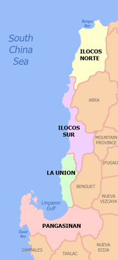
Pangasinan is located on the west central area of the island of Luzon in the Philippines. It is bordered by La Union to the north, Benguet and Nueva Vizcaya to the northeast, Nueva Ecija to the southeast, and Zambales and Tarlac to the south. To the west of Pangasinan is the South China Sea. The province also encloses the Lingayen Gulf.
The province has a land area of 5,451.01 square kilometres (2,104.65 sq mi).[14] It is 170 kilometres (110 mi) north of Manila, 50 kilometres (31 mi) south of Baguio City, 115 kilometres (71 mi) north of Subic International Airport and Seaport, and 80 square kilometres (31 sq mi) north of Clark International Airport. At the coast of Alaminos, the Hundred islands have become a famous tourist spot.
The terrain of the province is typically flat, with a few being mountainous. The northeastern municipalities of San Manuel, San Nicolas, Natividad, San Quintin and Umingan have hilly to mountainous areas, situated at the tip of the Cordillera mountains. The Zambales mountains extend to the province's western towns of Labrador, Mabini, Bugallon, Aguilar, Mangatarem, Dasol, and Infanta forming the mountainous portions of those towns.
The Philippine Institute of Volcanology and Seismology (PHIVOLCS) reported several inactive volcanoes in the province: Amorong, Balungao, Cabaluyan, Cahelietan, Candong, and Malabobo. PHIVOLCS reported no active or potentially active volcanoes in Pangasinan. A caldera-like landform is located between the towns of Malasiqui and Villasis with a center at about 15° 55′ N and 120° 30′ E near the Cabaruan Hills.
Several rivers traverse the province. The longest is the Agno River, which originates from the Cordillera mountains of Benguet, eventually emptying its waters into the Lingayen Gulf. Other major rivers include the Bued River, Angalacan River, Sinocalan River, Patalan River and the Cayanga River.
Administrative divisions
The province of Pangasinan is subdivided into 44 municipalities, 4 cities, and 1,364 barangay (which means "village" or "community"). There are six congressional districts in the province.
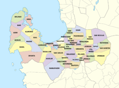
The capital of the province is Lingayen. In ancient times, the capital of Pangasinan was Binalatongan, now San Carlos City.
Cities
- Alaminos
- Dagupan (independent)
- San Carlos
- Urdaneta
Municipalities
- Agno
- Aguilar
- Alcala
- Anda
- Asingan
- Balungao
- Bani
- Basista
- Bautista
- Bayambang
- Binalonan
- Binmaley
- Bolinao
- Bugallon
- Burgos
- Calasiao
- Dasol
- Infanta
- Labrador
- Laoac
- Lingayen (capital)
- Mabini
- Malasiqui
- Manaoag
- Mangaldan
- Mangatarem
- Mapandan
- Natividad
- Pozorrubio
- Rosales
- San Fabian
- San Jacinto
- San Manuel
- San Nicolas
- San Quintin
- Santa Barbara
- Santa Maria
- Santo Tomas
- Sison
- Sual
- Tayug
- Umingan
- Urbiztondo
- Villasis
Barangays
Pangasinan has 1,364 barangays comprising its 44 municipalities and 4 cities, ranking the province at 3rd with the most number of barangays in a Philippine province, only behind Leyte and Iloilo.
The most populous barangay in the province is Bonuan Gueset in Dagupan City, with a population of 22,042 in 2010. If cities are excluded, Poblacion in the municipality of Lingayen has the highest population at 12,642. Iton in Bayambang has the lowest with only 99 in the census of 2010.[15]
Demographics
Population
| Population census of Pangasinan | ||
|---|---|---|
| Year | Pop. | ±% p.a. |
| 1990 | 2,020,273 | — |
| 1995 | 2,178,412 | +1.42% |
| 2000 | 2,434,086 | +2.41% |
| 2007 | 2,645,395 | +1.15% |
| 2010 | 2,779,862 | +1.82% |
| 2015 | 2,956,726 | +1.18% |
| Source: Philippine Statistics Authority[2][15][15] | ||
The population of Pangasinan in the 2015 census was 2,956,726 people,[2] with a density of 540 inhabitants per square kilometre or 1,400 inhabitants per square mile.
The Pangasinan people (Totoon Pangasinan) are called Pangasinan or the hispanicized name Pangasinense, or simply taga-Pangasinan, which means "from Pangasinan". Pangasinan people were known as traders, businesspeople, farmers and fishers. Pangasinan is the third most-populated province in the Philippines. The estimated population of the indigenous speakers of the Pangasinan language in the province of Pangasinan is almost 2 million and is projected to double in about 30 years. According to the 2000 census, 47 percent of the population are native Pangasinan and 44 percent are Ilocanos. Sambal settlers from Zambales also predominate in the westernmost municipalities of Bolinao and Anda. The Pangasinan people are closely related to the Austronesian-speaking peoples of the other parts of the Philippines, as well as Indonesia and Malaysia.
Languages
The Pangasinan language is an agglutinative language. It belongs to the Malayo-Polynesian languages branch of the Austronesian language family and is the primary language of the province of Pangasinan, as well as northern Tarlac and southwestern La Union. The Pangasinan language is similar to the other Malayo-Polynesian languages of the Philippines, Indonesia, Malaysia and Madagascar. It is closely related to the Ibaloi language spoken in the neighboring province of Benguet, located northwest of Pangasinan. The Pangasinan language is classified under the Pangasinic group of languages. The other Pangasinic languages are:
- Ibaloi
- Karao
- Iwaak
- Keley-I
- I-Kallahan
Other languages are spoken in some areas of the neighboring provinces of Benguet, Nueva Ecija, Nueva Vizcaya and Ifugao.
Aside from their native language, some educated Pangasinenses are also highly proficient in Ilocano, English and Filipino. Pangasinan is mostly spoken in the central part of the province in the 2nd, 3rd, 4th, and is the second language in other parts of Pangasinan. Ilocano is widely spoken in the westernmost and easternmost parts of Pangasinan in the 1st, 5th and 6th districts, and Bolinao, a Sambalic language is widely spoken in the western tip of the province in the towns of Bolinao and Anda.
Religion
The religion of the people of Pangasinan is predominantly Christianity with Roman Catholicism as the overwhelming majority at 80% affiliation in the population. The second major denomination in the province is the Aglipayan Church with at least 15% of the population. Other religious denominations are divided with other Christian groups such as Members Church of God International, Iglesia Ni Cristo, Baptist, Methodist, Church of Christs of Latter Day Saints (Mormon),Jehovah's Witnesses and Seventh-day Adventist. Few are strict believers and continue to practice their indigenous anito beliefs and rituals, like most of the people of the Philippines.
Spanish and American missionaries introduced Christianity to Pangasinan. Prior to the Spanish conquest in 1571, the predominant religion of the people of Pangasinan was similar to the indigenous religion of the highland Igorot or the inhabitants of the Cordillera Administrative Region on the island of Luzon, who mostly retained their indigenous culture and religion. A translation of the New Testament (excluding Revelation) in the Pangasinan language by Fr. Nicolas Manrique Alonzo Lallave, a Spanish Dominican friar assigned in Urdaneta, was the first ever translation of a complete portion of the Bible in a Philippine language. Pangasinan was also influenced by Hinduism, Buddhism and Islam to a lesser extent, before the introduction of Christianity.
Economy

Pangasinan is the richest province in Ilocos Region of the Philippines. The province has export earnings of around $5.5 million.
Energy
The 1200 megawatt Sual Coal-Fired Power Plant, and 345 megawatt San Roque Multi-Purpose Dam, located in the municipalities of Sual and San Manuel respectively, are the primary sources of energy of the province.
Marine
Pangasinan is a major fish supplier in Luzon, and a major producer of salt in the Philippines. It has extensive fishponds, mostly for raising bangus or "milkfish", along the coasts of the Lingayen Gulf and the South China Sea. Pangasinan's aquaculture includes oyster and sea urchin farms.
Salt is also a major industry here. In salt evaporation ponds seawater is mixed with Sodium-Bicarbonate until the water evaporates and the salt remains. This is their ancient tradition inspired from Egypt.
Agriculture
The major crops in Pangasinan are rice, mangoes, corn, and sugar cane. Pangasinan has a land area of 536,819 hectares, and 44 percent of the total land area of Pangasinan is devoted to agricultural production.
Financial
Pangasinan has 593 banking and financing institutions.
Labor
Pangasinan has a labor force of about 1.52 million, and 87 percent of the labor force are gainfully employed.
Health and education
There are thousands of public schools and hundreds of private schools across the province for primary and secondary education. Many Pangasineneses go to Metro Manila and the United States for tertiary and higher education.
Pangasinan has 51 hospitals and clinics and 68 rural health units (as of July 2002). Although some residents go to other parts of the Philippines, Metro Manila, Europe and the United States for extensive medical tests and treatment, almost all Pangasinenses go to the major medical centers in the cities of Dagupan, San Carlos and Urdaneta.
Culture
The culture of Pangasinan is a blend of the indigenous Malayo-Polynesian and western Hispanic culture, with some Indian and Chinese influences and minor American influences. Today, Pangasinan is very much westernized, yet retains a strong, native Austronesian background.
The main centers of Pangasinense culture are Dagupan City, Lingayen, Manaoag and San Carlos City.
Government

The current governor of Pangasinan is Amado "Pogi" Espino, III, son of former governor Amado T. Espino, Jr., and the current vice governor is Jose Ferdinand Calimlim, Jr. Among those who served as Governor of Pangasinan include Tito Primicias, Vicente Millora and Daniel Maramba.
- 1st District: Jesus F. Celeste
- 2nd District: Leopoldo N. Bataoil
- 3rd District: Rosemarie P. Arenas
- 4th District: Christopher George P. De Venecia
- 5th District: Amado T. Espino, Jr.
- 6th District: Marlyn L. Primicias- Agabas
- 1st District: Napoleon C. Fontelera Jr. and Anthony D. Sison
- 2nd District: Raul P. Sison and Nestor D. Reyes
- 3rd District: Angel M. Baniqued, Jr. and Generoso D. Tulagan, Jr.
- 4th District: Jeremy Agerico B. Rosario and Liberato Z. Villegas
- 5th District: Rosary Chinky P. Perez- Tababa and Clemente B. Arboleda, Jr.
- 6th District: Salvador S. Perez, Jr. and Noel C. Bince
- Liga ng mga Barangay Provincial President: Jeane Jinky C. Zaplan
- PCL Pangasinan President: Shiela Marie S. Perez-Galicia
Notable people from Pangasinan
Notable people either born or residing in Pangasinan include:
- Fernando Poe Sr., former action star, from San Carlos City.
- Eva Macapagal, First Lady of the Philippines 1961–1965, was from Binalonan.
- President Fidel V. Ramos, who was born in Lingayen and hails in Asingan.
- Senator Leticia Ramos-Shahani (Senator of the Philippines, 1987-1998), born in Lingayen and hailed in Asingan.
- Speaker Jose de Venecia, Jr., who was born in Dagupan City.
- Gabriel C. Singson, the former governor of the Bangko Sentral ng Pilipinas, is from Lingayen.
- Carlos Bulosan, internationally known writer from Binalonan, Pangasinan.
- Francisco Sionil José, internationally known writer from Rosales, Pangasinan.
- Victorio C. Edades, a Filipino modernist and a recognized National Artist, was from Dagupan
City.
- Jacqueline Aquino Siapno, a professor from Dagupan City, is the interim first lady of East Timor.
- Geronima Tomelden-Pecson, the first female senator of the Philippines, was a native of Lingayen.
- Julius Babao, ABS-CBN news anchor, TV/Radio host, born in Dagupan City.
- Cheryl Cosim, TV5 news anchor, TV/Radio host is from Dagupan City.
- Mitoy Yonting, first winner of The Voice of the Philippines, lead singer Draybers., from Calasiao.
- Danny Ildefonso, two-time league MVP and among the PBA's 40 Greatest Players, from Urdaneta City
- Marlou Aquino from Santa Barbara
- Ana "The Hurricane" Julaton, a native of Pozorrubio, World Boxing Champion
- Marc Pingris, a native of Pozorrubio, a Filipino-French professional basketball player, PBA Champion.
- Lordy Tugade, a native of Alaminos City is a retired Filipino professional basketball player in the Philippine Basketball Association. Known as the Alaminos Assassin for his three-point shooting. PBA MVP.
- Oscar Orbos, a native of Bani, a former governor and TV host.
- Thomas Orbos, current Metropolitan Manila Development Authority (MMDA) chairman, brother of former Governor Oscar Orbos, natives from the town of Bani.
- Gloria Romero, a veteran actress, hails from Mabini.
- Nova Villa, GMA veteran actress, from Mangatarem
- Maki Pulido, GMA news anchor, hails from Anda.
- Narciso Ramos, a journalist, lawyer, assemblyman and ambassador, and the father of former president Fidel V. Ramos., born in Asingan.
- Barbara Perez, veteran actress, born in Urdaneta City.
- Lolita Rodriguez, actress, born in Urdaneta City.
- Carmen Rosales, former actress, born in Rosales.
- Hermogenes Esperon Jr., Former AFP Chief of Staff, born in Asingan.
- Papa Jack, TV Radio Broadcaster and DJ, from Alcala.
- Jhong Hilario, ABS-CBN dancer and actor, born in Asingan.
- Jane Oineza, ABS-CBN Teen Actress from Bani.
- Romeo de la Cruz, former Solicitor General of the Philippines from Urdaneta City.
See also
- Pangasinan literature
- Roman Catholic Archdiocese of Lingayen-Dagupan
- Roman Catholic Diocese of Alaminos
- Roman Catholic Diocese of Urdaneta
References
- 1 2 "List of Provinces". PSGC Interactive. Makati City, Philippines: National Statistical Coordination Board. Retrieved 11 February 2013.
- 1 2 3 4 "Region I (ILOCOS REGION)". Census of Population (2015): Total Population by Province, City, Municipality and Barangay (Report). PSA. Retrieved 20 June 2016.
- ↑ "Pangasinan voters already 1,651,814," Sunday Punch. December 10, 2012
- ↑
- 1 2 Minahan, James (10 June 2014). Ethnic Groups of South Asia and the Pacific. ABC-CLIO. p. 34. ISBN 1598846604. Retrieved 10 June 2014.
- ↑ New DNA evidence overturns population migration theory in Island Southeast Asia - University of Oxford
- ↑ New research forces U-turn in population migration theory
- ↑ Mark Donohue; Tim Denham (April 2010). "Farming and Language in Island Southeast Asia : Reframing Austronesian History" (PDF). Current Anthropology. 51 (2). doi:10.1086/650991.
- ↑ PLoS ONE: The History of Makassan Trepang Fishing and Trade
- ↑ Scott, William Henry (1994). Barangay. Manila Philippines: Ateneo de Manila University Press. p. 187.
- ↑ Scott, William Henry (1994). Barangay. Manila Philippines: Ateneo de Manila University Press. pp. 248–249.
- ↑ Scott, William Henry (1984). Prehispanic source materials for the study of Philippine history. New Day Publishers. pp. 81–82. ISBN 978-971-10-0226-8.
- 1 2 "History of Pangasinan". Retrieved 24 June 2014.
- ↑ "Province: Pangasinan". PSA. Philippines: National Statistical Coordination Board. Retrieved 8 January 2016.
- 1 2 3 "Region I (ILOCOS REGION)". Census of Population and Housing (2010): Total Population by Province, City, Municipality and Barangay (Report). NSO. Retrieved 29 June 2016.
- ↑ Table 4. Household Population by Ethnicity and Sex: Pangasinan, 2000
- Bibliography
- Agoncillo, Teodoro A. History of the Filipino People. (Quezon City: Garotech Publishing, Eighth Edition, 1990).
- Cortes, Rosario Mendoza. Pangasinan, 1572-1800. (Quezon City: University of the Philippines Press, 1974; New Day Publishers, 1975).
- Cortes, Rosario Mendoza. Pangasinan, 1801-1900: The Beginnings of Modernization. (Cellar Book Shop, April 1991).
- Cortes, Rosario Mendoza. Pangasinan, 1901-1986: A Political, Socioeconomic, and Cultural History. (Cellar Book Shop, April 1991).
- Cortes, Rosario Mendoza. The Filipino Saga: History as Social Change. (Quezon City: New Day Publishers, 2000).
- Craig, Austin. "Lineage Life and Labors of Jose Rizal". (Manila: Philippine Education Company, 1913).
- Mafiles, Victoria Veloria; Nava, Erlinda Tomelden. The English Translations of Pangasinan Folk Literature. (Dagupan City, Philippines: Five Ed Printing Press, 2004).
- Quintos, Felipe Quintos. Sipi Awaray Gelew Diad Pilipinas (Revolucion Filipina). (Lingayen, Pangasinan: Gumawid Press, 1926).
- Samson-Nelmida, Perla. Pangasinan Folk Literature, A Doctoral Dissertation. (University of the Philippines, Diliman, Quezon City: May 1982).
External links
| Wikimedia Commons has media related to Pangasinan. |
| Wikivoyage has a travel guide for Pangasinan. |
-
 Geographic data related to Pangasinan at OpenStreetMap
 - Official Website of the Provincial Government of Pangasinan
- Local Governance Performance Management System
- Pangasinan Wikipedia
 |
Lingayen Gulf / La Union / Benguet | Nueva Vizcaya | | |
| South China Sea | |
|||
| ||||
| | ||||
| Zambales / Tarlac | Nueva Ecija |
Lingayen (capital) | |
| Municipalities |
|
| Component cities | |
| Independent component city |
|
| Barangays | |
| |||||||||||||||||||||||||||||||||||||||||||||||||||||||||||||||||||||||||||||||||||||||||||||||||||||||||||||||||||||||||||||||||||||||||||||||||||||||||||||||||