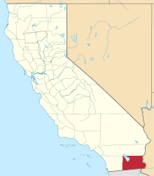
Imperial Valley


The Imperial Valley lies in California's Imperial County. It is located in southeastern Southern California, and is the site of an urban area largely centered on the city of El Centro. The Valley is bordered by the Colorado River to the east and, in part, the Salton Sea to the west. Farther west lies the San Diego and Imperial County border. To the north is the Inland Empire's Coachella Valley, which together form the Salton Trough, or the Cahuilla Basin, also the county line of Imperial and Riverside counties, and to the south the international boundary with the U.S. state of California and Baja California.
The culture of the area blends those of the United States and Mexico, due to its regional history and geographic location along the international border. The Imperial Valley economy is based on agriculture.
Imperial Valley was so named by the Imperial Land Company, in hopes of attracting settlers. Having done that it is now the home of the El Centro metropolitan area and also an economic center of California's government defined "South Border".[1] Locally, the terms "Imperial Valley" and "Imperial County" are used synonymously.
Geography

The Imperial Valley extends southward for 50 miles (80 km) from the southern end of the Salton Sea into Mexico. Part of a trough stretching from the Coachella Valley to the Gulf of California, it is almost entirely below sea level—235 feet (72 m) below at the edge of the Salton Sea. Its hot desert climate is characterized by daily temperature extremes. It was once part of the Gulf of California, from which it was cut off by the dam-like deposits of the Colorado River Delta Fan as it carved out the Grand Canyon.[2] Bordered by sand dunes and barren mountains, it was uninhabited until 1901, when the Imperial Canal was opened and diverted Colorado River water into the valley through Mexico. Flood-waters in 1905–07 destroyed the irrigation channels and created the Salton Sea now filled by the New River and irrigation run-off.[3] The rivers in the southern part of the Salton Sea river basin flow south to north.
The valley is bordered by the Colorado River to the east and, in part, the Salton Sea to the west. Farther west lies the border with San Diego County and to the south the international boundary between the US state of California and Baja California, Mexico. To the north is the boundary with the Inland Empire's Riverside County and its Coachella Valley, which with the Imperial Valley form the "Cahuilla Basin" or the "Salton Trough".
Climate
The Imperial Valley often has summer temperatures well over 100 °F (38 °C), but from late October until mid-April the temperature is relatively mild and can sometimes even reach low temperatures not expected in a desert. During winter months the Valley averages more than eight hours of sunshine a day, receiving the most sunlight of any place in the United States.[4]
Historically, the lowest minimum temperature ever recorded in the Imperial Valley was 16 °F (−9 °C) on January 22, 1937. The highest maximum temperature ever recorded was 121 °F (49 °C) on July 28, 1995. The lowest maximum temperature was 42 °F (6 °C), recorded on January 24, 1949, and the highest minimum temperature was 92 °F (33 °C) on June 30, 1946. The highest monthly mean temperature was 95.9 °F (35.5 °C), recorded in August 1969 and the lowest mean temperature was 42.3 °F (5.7 °C) in February 1939.[4]
The 85-year average annual rainfall is 2.93 inches (74 mm) with June being the driest month. The only recorded snowfall in the Valley occurred on December 12, 1932. Snow began falling at 8:45 p.m. and by 5 a.m. The next day 2.5 inches (6 cm) had been recorded. In the southwest portion of Imperial Valley, 4 inches (10 cm) of snow was reported that day. This was the only snowfall of record to cover the entire valley. [4]
Population
The El Centro Metropolitan Area is home to 163,972 residents, according to a 2008 US Census estimate, and encompasses the whole Imperial County. The area is in the far southeast region of the State of California. Major population centers are Brawley, Calexico, and El Centro, which is the county seat.
Imperial County had the largest percentage increase in population in California between 2008 and 2009 in the state, according to the California Department of Finance. The county had a population growth rate of 2.2 percent between July 1, 2008, and July 1, 2009. The county’s growth rate has consistently been one of the top 10 out of 58 counties in California for the past six years. Last year’s growth rate was 2.43 percent.
El Centro is the largest industrial center of the Imperial Valley, being the center of shipping exports as well as being home to retail, transportation, wholesale, and agricultural industries. There are also two international border crossings nearby for commercial and noncommercial vehicles. The city's population was 37,835 at the 2000 census. The 2006 population is 40,563. The city is 50 feet (20 m) below sea level and the largest city in the United States below sea level. Fifty percent of the jobs in El Centro come from the service and retail sector.
Regions
Imperial Valley can loosely categorize its cities and communities into three regions: the Salton Beach Towns, Desert Cities, and the El Centro area (urbanized Imperial). The Salton Sea Beach Towns have the smallest cities but were resorts in their heyday and have since shrunk in population and size due to the current state of the Salton Sea. The cities and communities of the desert region are outliers in that they are away from urbanized Imperial and tend to be smaller in population than the cities surrounding El Centro. Cities of the El Centro area tend to be larger than those of the desert and Salton regions.
Imperial Valley cities
Cities over 10,000 population

Cities under 10,000 population
Towns over 1,000 population

Towns under 1,000 population
Urban areas of the region
The El Centro, CA MSA is a multicore metropolitan region containing several urban areas. While most urban areas are located in the metropolitan area, the Yuma, AZ CA-AZ urban area spills over into Winterhaven. Populations are from the U.S. Census Bureau.[5]
| Population rank |
Name | State(s) | Type (UA/UC) | 2009 population |
|---|---|---|---|---|
| 1 | Yuma | CA-AZ | UA | 94,842 |
| 2 | El Centro | CA | UA | 56,006 |
| 3 | Calexico | CA | UC | 32,158 |
| 4 | Brawley | CA | UC | 22,747 |
Economics
Imperial County’s economy consists predominantly of government, agriculture, and retail trade that represents approximately 70% of total county employment. Government services account for over one-third of total employment. Agriculture accounts for one-fourth of jobs with major crops of alfalfa, lettuce, sugar beets and carrots. Retail growth has been experienced due to increased population in the Imperial and Mexicali Valleys. In 2005, the Imperial Valley Mall opened, attracting shoppers from the Valley area, including residents and tourists across the border from Mexicali, greatly contributing to the county’s retail sales.
Tourism
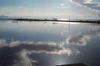
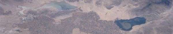
Tourism is considered the secondary industry of the Imperial Valley. Many visitors come to the area to visit the Salton Sea (California's largest inland lake, which serves as a dumpout point for the overflow and drainage from the IID canal system and ditch drainage) and the Algodones Dunes. The New River and the Alamo River flow from the border city of Mexicali northward to the Salton Sea.
Another popular destination is the Salton Sea mud pots and volcanoes. These mud pots and volcanoes are located in an open field on the eastern side of the Salton Sea. The mud is just above ambient temperature and you can walk right up to the vents. However, this is a natural system and temperatures will vary. Caution is advised. The location is host to a number of gray cones reaching heights of six feet (2 m) and depressions filled with bubbling mud. These features are the result of the geothermal activity in the area.[6]
Off-roading on ATV's is another popular activity during the winter months. Heber Dunes State Vehicular Recreation Area is located south of El Centro and is primarily an off-roading destination. The valley sand dune recreation area draws hundreds of thousands of off-road enthusiasts on good weekends. Bird-watching is a popular activity, with abundant natural habitat and rare species. The Imperial Valley has an array of excellent golf courses for all levels. Golf courses are in Holtville, Brawley and El Centro.[7]
Sites of interest
Fort Yuma
Fort Yuma is located on the banks of the Colorado River in Winterhaven, California. First established after the end of the Mexican-American War in 1848, it was originally located in the bottoms near the Colorado River, less than 1-mile (1.6 km) below the mouth of the Gila River. It was to defend the newly settled community of Yuma, Arizona on the other side of the Colorado River and the nearby Mexican border. In March 1851 the post was moved to a small elevation on the Colorado's west bank, opposite the present city of Yuma, Arizona, on the site of the former Mission Puerto de Purísima Concepción. This site had been occupied by Camp Calhoun, named for John C. Calhoun, established in 1849. Fort Yuma was established to protect the southern emigrant travel route to California and to attempt control of the warlike Yuma Indians in the surrounding 100-mile (160 km) area.[8]

Blue Angels
NAF El Centro is the winter home of the U.S. Navy Flight Demonstration Squadron, The Blue Angels. NAF El Centro historically kicks off the Blue Angels' season with their first air show, traditionally held in March.[9]
Imperial Valley Expo & Fairgrounds
The Imperial Valley Expo & Fairgrounds is home to the California Mid-Winter Fair and Fiesta, which is the local county fair. It is also home to the Imperial Valley Speedway, a 3⁄8 mile (600 m) race track.[10]
Algodones Sand Dunes
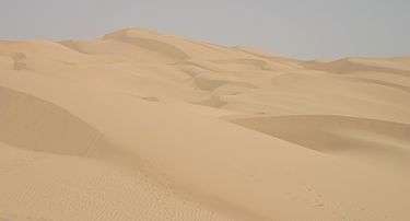
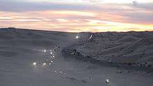
The name Algodones Dunes refers to the entire geographic feature, while the administrative designation for that portion managed by the Bureau of Land Management is the "Imperial Sand Dunes Recreation Area" (sometimes called the "Glamis Dunes"). The Algodones Sand Dunes are the largest mass of sand dunes in California. This dune system extends for more than 40 miles (60 km) along the eastern edge of the Imperial Valley agricultural region in a band averaging 5 miles (8 km) in width. A major east-west route of the Union Pacific railroad skirts the eastern edge. The dune system is divided into 3 areas. The northernmost area is known as Mammoth Wash. South of Mammoth Wash is the North Algodones Dunes Wilderness established by the 1994 California Desert Protection Act. This area is closed to motorized use and access is by hiking and horseback. The largest and most heavily used area begins at Highway 78 and continues south just past Interstate 8. The expansive dune formations offer picturesque scenery, a chance to view rare plants and animals, and a playground for ATV and off-roading enthusiasts. The dunes are also popular in film-making and have been the site for movies such as Return of the Jedi.[11]
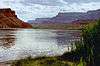
Colorado River
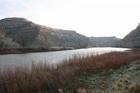
The Colorado River is a popular destination for water sports including fishing, boating, water-skiing, and jet-skiing. The Colorado River is a river in the southwestern United States and northwestern Mexico, approximately 1,450 miles (2,330 km) long, draining a part of the arid regions on the western slope of the Rocky Mountains. The natural course of the river flows from north of Grand Lake, Colorado into the Gulf of California. For many months out of the year, however, no water actually flows from the United States to the gulf, due to human consumption.
Salvation Mountain
Salvation Mountain (location 33°15′14.9″N 115°28′21.4″W / 33.254139°N 115.472611°W) is a colorful artificial mountain north of Calipatria, California, near Slab City. It is made from adobe, straw, and thousands of gallons of paint. It was created by Leonard Knight to convey the message that "God Loves Everyone". Mr. Knight refused substantial donations of money and labor from supporters who wished to modify his message of universal love to favor or disfavor particular groups.
Anza-Borrego Desert State Park

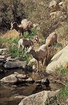
Anza-Borrego Desert State Park, portions of which are located in Imperial County, is the largest state park in California. 500 miles (800 km) of dirt roads, 12 wilderness areas and miles of hiking trails provide visitors with an unparalleled opportunity to experience the wonders of the Colorado Desert. The park is named after Spanish explorer Juan Bautista de Anza and the Spanish name borrego, or bighorn sheep. The park features washes, wildflowers, palm groves, cacti and sweeping vistas. Visitors may also have the chance to see greater roadrunners, golden eagles, kit foxes, southern mule deer and Peninsular bighorn sheep, as well as desert iguanas, chuckwallas, and sidewinders.
Fossil Canyon and Painted Gorge
Located near Ocotillo, California in the Coyote Mountains, Fossil Canyon and the surrounding area is a great place for rock hounding and fossil hunting. The fossils here are not dinosaurs, but ancient shells, coral, and oysters from the Miocene epoch when the area was underwater.[12]
The Painted Gorge, located on the eastern side of the Coyote Mountains, consists of sedimentary, metamorphic and igneous rocks. Heat and movement over time has created fantastic shapes and colors. Oranges, reds, purples, and mauves mixed with browns and blacks create a palette of color as the sun illuminates and plays shadows upon this geologic wonder.[12]
Imperial NWR

The Imperial National Wildlife Refuge protects wildlife habitat along 30 miles (50 km) of the lower Colorado River in Arizona and California, including the last un-channeled section before the river enters Mexico. The river and its associated backwater lakes and wetlands are a green oasis, contrasting with the surrounding desert mountains. It is a refuge and breeding area for migratory birds and local desert wildlife.[13]
Sonny Bono Salton Sea NWR
The Sonny Bono Salton Sea National Wildlife Refuge is located 40 miles (60 km) north of the Mexican border at the southern end of the Salton Sea in California’s Imperial Valley. Situated along the Pacific Flyway, the refuge is the only one of its kind, located 227 feet (69 m) below sea level. Because of its southern latitude, elevation and location in the Colorado Desert, the refuge experiences some of the highest temperatures in the nation. Daily temperatures from May to October generally exceed 100 °F with temperatures of 116°-120 °F recorded yearly.[14]
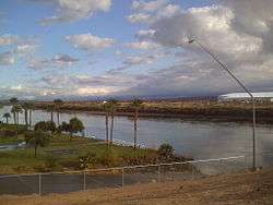
Mexicali
The border city of Mexicali, Baja California, Mexico, offers big-city amenities like museums, a zoo, a sports convention center, and an international airport. Visitors cross by foot or car from Calexico, California in the United States every day. Restaurants and taco stands, pharmacies, bars and dance clubs are part of the draw for the city's tourists. Many shops and stalls selling Mexican crafts and souvenirs are also located in walking distance from the border. Also many residents from California, Arizona and Nevada look for medical and dental services in Mexicali, because they tend to be less expensive than those in the United States. Mexico's drinking age of 18 (vs. 21 in the United States) makes it a common weekend destination for many high school and college-aged Southern Californians. The town was near the epicenter of the 2010 Baja California earthquake (on Easter Sunday, April 4, 2010).
Agriculture

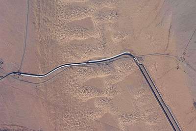
Although this region is in the Colorado Desert section of the Sonoran Desert, with high temperatures and low average rainfall of 3 inches (76 mm) per year, the economy is heavily based on agriculture due to irrigation, which is supplied wholly from the Colorado River via the All-American Canal. Thousands of acres of prime farmland have transformed the desert into one of the most productive farming regions in California with an annual crop production of over $1 billion. Agriculture is the largest industry in the Imperial Valley and accounts for 48% of all employment. An environmental cost is that, south of the canal, the Colorado River no longer flows above ground at all for much of the year into Mexico.
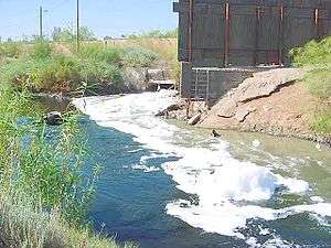
A vast system of canals, check dams, and pipelines carry the water all over the valley, a system which forms the Imperial Irrigation District, or IID. The water distribution system includes over 1,400 miles (2,300 km) of canal and with 1,100 miles (1,800 km) of pipeline. The number of canal and pipeline branches number roughly over a hundred. Imported water and a long growing season allow two crop cycles each year, and the Imperial Valley is a major source of winter fruits and vegetables, cotton, and grain for U.S. and international markets. Alfalfa is another major crop produced in the Imperial Valley. The agricultural lands are served by a constructed agricultural drain system, which conveys surface runoff and subsurface drainage from fields to the Salton Sea, which is a designated repository for agricultural runoff, with environmental considerations not yet solved.
Renewable energy
Imperial Valley has become a "hot-bed" of renewable energy projects, both solar and geothermal.[15] This is driven in part by California's mandate to generate 33% of its electricity from renewable sources by 2020, the valley's excellent sun resources, the high unemployment, its proximity to large population centers on the coast, and large tracts of otherwise unusable desert land.[15]
Much of the land suitable for green energy is owned by the federal government (Bureau of Land Management). As of April 2008, the BLM has received 163 applications to build renewable energy projects on 1,600,000 acres (6,500 km2) in California, "almost all of them are planned for the Imperial Valley and the desert region north of the valley."[15] Stirling Energy is currently building one of the world's largest solar thermal plants, 10 square miles (26 km2) with 38,000 "sun catchers," it will power up to 600,000 homes once it is fully operational by around 2015.[15] CalEnergy currently runs a geothermal plant that generates 340 megawatts, enough power for 300,000 homes, and could tap into more for up to 2.5 million homes.[15]
In addition, in 2012 Synthetic Genomics bought an 81 acre site in the Imperial Valley to produce algae fuel with their engineered algae strains, as well as other algae products such as food.[16]
Demographics
The Imperial and Mexicali Valleys share a common international bond of both American and Hispanic cultures. On the U.S. side, the majority of residents are of Mexican-American or Latino heritage, while the Mexican side has been greatly influenced by American culture by the U.S. for many decades. The entire valley has multi-racial representation of Africans, Europeans, east and south Asians, and Native Americans.
As of the census of 2000, there were 142,361 people, 39,384 households, and 31,467 families residing in the county. The population density was 34 people per square mile (13/km²). There were 43,891 housing units at an average density of 10 per square mile (4/km²). The racial makeup of the county was 49.4% white, 4.0% black or African American, 1.9% Native American, 2.0% Asian, 0.1% Pacific Islander, 39.1% from other races, and 3.7% from two or more races. 72.2% of the population were Hispanic or Latino of any race. 65.7% spoke Spanish and 32.3% English as their first language.
There were 39,384 households out of which 46.7% had children under the age of 18 living with them, 57.7% were married couples living together, 17.1% had a female householder with no husband present, and 20.1% were non-families. 17.1% of all households were made up of individuals and 8.1% had someone living alone who was 65 years of age or older. The average household size was 3.33 and the average family size was 3.77. In the county the population was spread out with 31.4% under the age of 18, 9.9% from 18 to 24, 30.4% from 25 to 44, 18.2% from 45 to 64, and 10.0% who were 65 years of age or older. The median age was 31 years. For every 100 females there were 109.3 males. For every 100 females age 18 and over, there were 111.4 males.
| Year | DEM | GOP | Others |
|---|---|---|---|
| 2008 | 61.1% 17,761 | 37.3% 10,850 | 1.6% 459 |
| 2004 | 52.4% 17,964 | 46.4% 15,890 | 1.2% 420 |
| 2000 | 53.5% 15,489 | 43.3% 12,524 | 3.2% 924 |
| 1996 | 55.3% 14,591 | 36.8% 9,705 | 8.0% 2,104 |
| 1992 | 43.9% 11,109 | 38.5% 9,759 | 17.6% 4,450 |
| 1988 | 43.8% 10,243 | 55.2% 12,889 | 1.0% 233 |
| 1984 | 36.9% 8,237 | 62.0% 13,829 | 1.1% 235 |
| 1980 | 36.9% 7,961 | 55.9% 12,068 | 7.2% 1,550 |
| 1976 | 48.2% 10,244 | 49.9% 10,618 | 1.9% 400 |
| 1972 | 34.9% 7,982 | 62.1% 14,178 | 3.0% 689 |
Politics
Imperial County is a Democratic stronghold in Presidential, Congressional, and local elections. The last Republican to win a majority in the county was George H. W. Bush in 1988.
On November 4, 2008, Imperial County voted 69.7% for Proposition 8, which amended the California Constitution to ban same-sex marriages, showing more support for the proposition than any other strongly Democratic county.[17][18]
Imperial is part of California's 51st congressional district, which is held by Democrat Juan Vargas. In the state legislature, Imperial is part of California's 56th State Assembly district, which is held by Democrat Manuel Perez, and the 40th Senate district, which is held by Democrat Denise Ducheny.
The median income for a household in the county was $31,870, and the median income for a family was $35,226. Males had a median income of $32,775 versus $23,974 for females. The per capita income for the county was $13,239. About 19.4% of families and 22.6% of the population were below the poverty line, including 28.7% of those under age 18 and 13.6% of those age 65 or over.
Education
Schools in the Imperial Valley
The Imperial Valley has many schools to offer education; high schools, middle/junior high school, elementary schools, and college. Central Union High School, Southwest High School, Calexico High School Holtville High School, Imperial High School, and Brawley Union High School are some of the high schools Imperial Valley has to offer. Imperial Valley College, located in Imperial, California, and SDSU Imperial Valley Extension, located in Calexico, California, are the colleges the Imperial Valley has to offer. The valley also offers a partnership between the local community college, Imperial Valley College, and SDSU's extension which offers a four-year bachelor's degree for students in the area. The program was formally named imperial Valley Partnership University. This partnership was intended to provide students in the valley the opportunity to stay within the area while being able to acquire a bachelor's degree for an affordable price without having to transfer to a distant four-year university. The program hosted its first cohorts in the Fall of 2012 and since then has offered various academic programs such as Criminal Justice, History, Liberal Studies, Psychology, Public Administration, and Spanish. Imperial Valley University Program, respectably known as IVUP, has not only offered affordable education and the opportunity to stay local for students in the Imperial Valley, but it has also provided priority registration, scholarship opportunities, and the ability to use resources from both the IVC's and SDSU's campuses. IVUP continues to expand in each academic term and actively does outreach throughout different high schools in the valley by performing presentations and one-on-one interviews with students who express interest.[19]
Transportation
Major highways

-
.svg.png) Interstate 8
Interstate 8 -
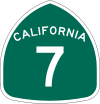 State Route 7
 -
 State Route 78
 -
 State Route 86
 -
 State Route 98
 -
 State Route 111
 -
 State Route 115
Public transportation
Airports
Imperial County Airport is the main airport in the county. It is primarily a general aviation airport with limited commercial flight service. The major nearby airport is the San Diego International Airport.
| Airport | IATA code | ICAO code | City |
|---|---|---|---|
| Calexico International Airport | CXL | KCXL | Calexico |
| Holtville Airport | L04 | none | Holtville |
| Imperial County Airport | IPL | KIPL | Imperial |
Culture
Robert A. Heinlein's science fiction short story "Water is for Washing" (Argosy, November 1947) was based on the premise that an earthquake had catastrophically shattered the range of deposits separating the Imperial Valley from the Gulf of California, precipitating a tidal wave moving north to transiently drown these lowlands. At the beginning of the story, Heinlein uses the character of a bartender in El Centro to establish the danger of the quake and inundation:
- "You've heard about the 1905 flood, when the Colorado River spilled over and formed the Salton Sea? But don't be too sure about quakes; valleys below sea level don't just grow — something has to cause them. The San Andreas Fault curls around this valley like a question mark. Just imagine the shake-up it must have taken to drop thousands of square miles below the level of the Pacific."
Heinlein's perspective character is a traveling businessman who had picked up two chance-encountered children and a vagrant while driving frantically to higher ground, and the dramatic arc centers on the efforts of the men to survive and save the youngsters from drowning.
Due to its desert environment and proximity to Los Angeles, California, movies are sometimes filmed in the sand dunes outside the agricultural portions of the Imperial Valley. These have included
- American Sniper
- Return of the Jedi
- Independence Day
- Stargate
- The Scorpion King
- Patriot Games
- Into the Wild
- The Men who Stare at Goats
- La Bamba
- The original "Flight of the Phoenix" (1965) was filmed outside of Holtville.
- The Tom Cruise Movie "Losin' It" (1983) was filmed in Calexico.
Additionally, portions of the 2005 film Jarhead were filmed here because of its similarity to the desert terrain of Iraq. Mountains that were visible in the background during filming were digitally removed during postproduction.
Notables
- Edith Summers Kelley – author
- Sergio Romo – MLB pitcher
- Rudy Seánez – former MLB pitcher
- Mike Mohamed – NFL linebacker
- Robert Thomas – NFL linebacker
- Cher – entertainer
See also
- 1940 El Centro earthquake
- 1979 Imperial Valley earthquake
- Imperial Valley Press
- O. M. Wozencraft - "Father of the Imperial Valley"
Footnotes
- ↑ "El Centro Economics" (PDF). California Economic Strategy Panel.
- ↑ Grand Canyon Sediment Deposit
- ↑ Geography
- 1 2 3 Imperial Valley Climate (from Wayback Machine)
- ↑ U.S. Census Bureau Urban Areas in California
- ↑ Salton Sea mud pots & volcanoes
- ↑ Imperial Valley Lifestyle
- ↑ "Fort Yuma". Retrieved 2009-08-05.
- ↑ "Blue Angels Official Website". Archived from the original on 2009-08-03. Retrieved 2009-08-05.
- ↑ "Imperial Valley Expo". Retrieved 2009-08-05.
- ↑ "Algodones Sand Dunes". Retrieved 2009-08-05.
- 1 2 "Fossil Canyon and Painted Gorge". Retrieved 2009-08-05.
- ↑ "Imperial NWR". Archived from the original on 2009-06-12. Retrieved 2009-08-04.
- ↑ "Sonny Bono Salton Sea National Wildlife Refuge". Retrieved 2009-08-04.
- 1 2 3 4 5 "Calif. Desert Becomes Home For Renewable Energy", Rob Schmitz, Morning Edition, April 3, 2009, NPR.
- ↑ http://www.syntheticgenomics.com/media/press/052412.html Synthetic Genomics Press Release: May 24, 2012
- ↑ "Proposition 8 Map - November 4, 2008, General Election - California Secretary of State:". Retrieved 2009-08-17.
- ↑ "Registration by County". Retrieved 2009-08-17.
- ↑ http://www.ivup.org
Further reading
- Benny J. Andrés, Jr. Power and Control in the Imperial Valley: Nature, Agribusiness, and Workers in the California Borderland, 1900-1940. College Station, TX: Texas A&M University Press, 2014.
External links
- Imperial Valley Economic Development Corporation
- City of El Centro Website
- City of Imperial Website
- From the Colorado River to the Salton Sea: The story of Imperial Valley's Water (slideshow)
- U.S. Geological Survey Geographic Names Information System: Imperial Valley
Coordinates: 32°44′51″N 114°57′48″W / 32.74750°N 114.96333°W

Colorado River system | |||||||||||||||
|---|---|---|---|---|---|---|---|---|---|---|---|---|---|---|---|
| Jurisdictions |
|     | |||||||||||||
| Canyons |
| ||||||||||||||
| Natural features |
| ||||||||||||||
| Tributaries | |||||||||||||||
| Engineering |
| ||||||||||||||
| Designated areas | |||||||||||||||
| Related topics | |||||||||||||||