San Marcos, California
| San Marcos, California | ||
|---|---|---|
| Charter city | ||
| City of San Marcos | ||
|
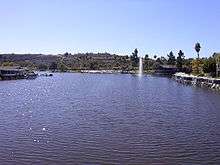
Looking North toward Lake San Marcos | ||
| ||
| Nickname(s): Valley of Discovery | ||
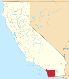
 Location in San Diego County and the state of California | ||
 San Marcos, California Location in the United States | ||
| Coordinates: 33°8′31″N 117°10′13″W / 33.14194°N 117.17028°WCoordinates: 33°8′31″N 117°10′13″W / 33.14194°N 117.17028°W[1] | ||
| Country |
| |
| State |
| |
| County | San Diego | |
| Incorporated | January 28, 1963[2] | |
| Chartered | July 4, 1994[3] | |
| Government | ||
| • Type | Council/Manager[4] | |
| • Mayor | Jim Desmond[5] | |
| Area[6] | ||
| • Total | 24.390 sq mi (63.169 km2) | |
| • Land | 24.370 sq mi (63.117 km2) | |
| • Water | 0.020 sq mi (0.053 km2) 0.08% | |
| Population (April 1, 2010)[7] | ||
| • Total | 83,781 | |
| • Estimate (2013)[7] | 89,387 | |
| • Density | 3,400/sq mi (1,300/km2) | |
| Time zone | Pacific (UTC-8) | |
| • Summer (DST) | PDT (UTC-7) | |
| ZIP codes | 92069, 92078, 92079, 92096 | |
| Area codes | 442/760 | |
| FIPS code | 06-68196 | |
| GNIS feature IDs | 1661388, 2411797 | |
| Website |
www | |


San Marcos is a city in the North County region of San Diego County in the U.S. state of California. As of the 2010 census, the city's population was 83,781. It is the site of California State University San Marcos. The city is bordered by Escondido to the east, Encinitas to the southwest, Carlsbad to the west, and Vista to the northwest.
History
According to historical legends, the San Luis Rey Mission flocks were robbed by a small band of Native Americans in the late 18th century. Fleeing the Spanish troops, the Native Americans escaped to the hills. While pursuing the Native Americans, in 1797 the Spaniards came upon a fertile valley, which was named Los Vallecitos de San Marcos (Little Valleys of Saint Mark) to honor the day of discovery: April 25, St. Mark’s Day. On April 22, 1840, Governor Juan B. Alvarado granted Rancho Vallecitos de San Marcos to his relative, Jose María Alvarado. Jose Alvarado was killed at the Pauma Massacre in 1846, and the land was left to his wife; she then sold the land to Lorenzo Soto. In the late 1850s, Soto sold part of his land to Cave Couts, and his family was soon raising livestock. Although Cave Couts owned the land, Major Gustavus French Merriam from Topeka, Kansas, made the first permanent settlement. Merriam homesteaded 160 acres (0.65 km2) in the north Twin Oaks Valley and began wine and honey production.
After Major Merriam’s settlement, German and Dutch immigrants began moving into the area in the early 1880s. In 1883, a few miles south of the settlement, John H. Barham (for whom the present-day Barham Drive is named) founded the first town in the area, originally situated on the southeast corner of what are now Rancho Santa Fe Road and San Marcos Boulevard. By 1884, the town of Barham had a post office, blacksmith, feed store and weekly newspaper. In 1887, the San Marcos Land Company bought almost all of the San Marcos land formerly owned by the Couts family and promptly divided the land into tracts. Soon the beautiful hills began attracting home-seekers.
The original town of San Marcos was about a mile north of Barham, at the intersection of what is now Grand Avenue and Rancho Santa Fe Road. In 1887, the Santa Fe Railroad announced that it was going to lay tracks going through the valley, but to the disappointment of the citizens, the tracks were laid one mile (1.6 km) from the center of the town. By 1896, San Marcos was a community with its own stores, post office, blacksmith, and railroad depot. The first school in the area, which was started in Barham in 1886, had been moved to San Marcos three years later, as Barham was fading due to its distance from the railroad. To prevent San Marcos from suffering a similar fate, in 1903 the people of the town picked up their homes and moved a couple miles east along the railroad tracks to what now are Mission Road and Pico Avenue. By 1905, the town had every convenience, including rural mail delivery and telephone service. Later that same year, the Richland School (now a wedding chapel on Woodland Avenue) was built, becoming the second school in San Marcos. The main business in San Marcos in the 19th and early 20th centuries was farming. In the mid-20th century, dairies and poultry production became a big part of the business in the town.
San Marcos experienced a period of growth from 1956 onward, when the first water from the Colorado River arrived. Several small businesses were founded and the population rapidly increased to 2,500. San Marcos became an incorporated city on January 28, 1963. In the 1970s, San Marcos was flourishing as the third fastest-growing city in the state, and had a population of 17,479 by 1980. The population continued to boom over the next two decades, surpassing 30,000 in 1990 and nearing 85,000 by 2010.
Geography and climate
According to the United States Census Bureau, the city has a total area of 24.4 square miles (63 km2). 24.4 square miles (63 km2) of it is land and 0.02 square miles (0.052 km2) of it (0.08%) is water. Due to the moderating influence of the nearby Pacific, temperatures rarely fall below freezing in winter and above 90 degress F. in summer. Like most of coastal San Diego County, cool overcast from the Pacific is common in May and June ("May gray", "June gloom"). July through September are usually the warmest months, although hot and dry Santa Ana winds can strike any month (most common Autumn) and raise risks of wildfires. Most of the rain falls between November and March, averaging about 13 inches per year, with up to 20 inches falling in the San Marcos Hills.
Economy
Top employers
According to the City's 2015 Comprehensive Annual Financial Report,[8] the top employers in the city are:
| Rank | Employer | # of Employees | % of total employment |
|---|---|---|---|
| 1 | Hunter Industries | 740 | 1.90% |
| 2 | United Parcel Service | 484 | 1.24% |
| 3 | So. CA Permanente Med Group | 403 | 1.04% |
| 4 | Wal-Mart | 350 | 0.90% |
| 5 | Costco Wholesale | 350 | 0.90% |
| 6 | 24 Hour Fitness | 318 | 0.82% |
| 7 | Lusardi Construction Co. | 300 | 0.77% |
| 8 | RB III Associates Inc. | 259 | 0.67% |
| 9 | Fluid Components Intl. LLC | 245 | 0.63% |
| 10 | University Aux. & Research Services | 230 | 0.59% |
Education
San Marcos Unified School District
The San Marcos Unified School District is one of the largest school districts in San Diego County and includes 20 schools with diverse educational programs for kindergarten through adult education students. SMUSD has 11 elementary schools, 3 middle schools, 1 K-8 school, 2 comprehensive high schools, 1 charter high school, 1 independent study high school and 1 continuation school. SMUSD serves more than 20,000 students in San Marcos, as well as sections of Vista, Escondido, Carlsbad, and some unincorporated areas of the County. [9]
High Tech High, Middle, and Elementary, North County
High Tech High, Middle, elementary and are all charter schools located in San Marcos. High Tech High, which started with a single school in 2000, is known for its small-school settings, where students learn through projects, internships and interaction with professionals. [10]
Palomar College
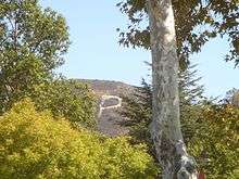
The main 200-acre (0.81 km2) campus of Palomar College is located in northern San Marcos. It is a public two-year community college and is a member of the California Community Colleges system. It enrolls approximately 30,000 full-time and part-time students. Palomar offers more than 250 associate degree and certificate programs, and residents of California are charged $46 per unit.
A giant letter P (for "Palomar") on the hillside above the campus is a ubiquitous landmark for San Marcos, visible miles away.[11]
Cal State San Marcos

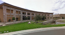
Cal State San Marcos is a smaller campus in the California State University system. It was founded in 1989 and built on a 304-acre (1.23 km2) hillside in southeastern San Marcos. It enrolls about 9,000 students and offers 44 undergraduate programs, 10 graduate programs and 1 Doctorate in Education in three colleges and one nursing school.
University of St. Augustine
The University of St. Augustine for Health Sciences is a Physical and Occupational Therapy graduate institution. The university's mission is the professional development of health care providers through innovative and individualized education. They offer a unique, hands-on curriculum which provides students with the tools it takes to become skilled clinicians. The University of St. Augustine for Health Sciences offers Doctoral Degrees in both Physical Therapy (DPT) and Occupational Therapy (OTD).
Government
San Marcos uses a council-manager system of government with a separately elected mayor. The city council consists of the mayor and four other members, who are elected at-large to alternating four-year terms. As of March 2015, mayor is Jim Desmond, the vice mayor is Rebecca Jones, and the other councilmembers are Kristal Jabara, Chris Orlando, and Sharon Jenkins.[5]
As of March 2015, the city manager is Jack Griffin.[12]
At the state level, San Marcos is represented by Assemblymember Marie Waldron in the 75th Assembly district, and Senator Joel Anderson in the 38th Senate District. The city is represented by Bill Horn in the 5th district of the County Board of Supervisors.
Federal representation
With respect to the United States House of Representatives, San Marcos is in California's 50th congressional district, represented by Republican Duncan D. Hunter.[13]
Demographics
| Historical population | |||
|---|---|---|---|
| Census | Pop. | %± | |
| 1970 | 3,896 | — | |
| 1980 | 17,479 | 348.6% | |
| 1990 | 38,974 | 123.0% | |
| 2000 | 54,977 | 41.1% | |
| 2010 | 83,781 | 52.4% | |
| Est. 2015 | 92,931 | [14] | 10.9% |
2010
The 2010 United States Census[16] reported that San Marcos had a population of 83,781. The population density was 3,435.1 people per square mile (1,326.3/km²). The racial makeup of San Marcos was 53,235 (63.5%) White, 1,967 (2.3%) African American, 591 (0.7%) Native American, 7,518 (9.0%) Asian, 322 (0.4%) Pacific Islander, 15,853 (18.9%) from other races, and 4,295 (5.1%) from two or more races. Hispanic or Latino of any race were 30,697 persons (36.6%).
The Census reported that 82,937 people (99.0% of the population) lived in households, 736 (0.9%) lived in non-institutionalized group quarters, and 108 (0.1%) were institutionalized.
There were 27,202 households, out of which 11,724 (43.1%) had children under the age of 18 living in them, 15,242 (56.0%) were opposite-sex married couples living together, 3,056 (11.2%) had a female householder with no husband present, 1,513 (5.6%) had a male householder with no wife present. There were 1,372 (5.0%) unmarried opposite-sex partnerships, and 186 (0.7%) same-sex married couples or partnerships. 5,168 households (19.0%) were made up of individuals and 2,370 (8.7%) had someone living alone who was 65 years of age or older. The average household size was 3.05. There were 19,811 families (72.8% of all households); the average family size was 3.49.
The population was spread out with 23,287 people (27.8%) under the age of 18, 9,215 people (11.0%) aged 18 to 24, 25,237 people (30.1%) aged 25 to 44, 17,515 people (20.9%) aged 45 to 64, and 8,527 people (10.2%) who were 65 years of age or older. The median age was 32.9 years. For every 100 females there were 95.6 males. For every 100 females age 18 and over, there were 92.6 males.
There were 28,641 housing units at an average density of 1,174.3 per square mile (453.4/km²), of which 17,094 (62.8%) were owner-occupied, and 10,108 (37.2%) were occupied by renters. The homeowner vacancy rate was 2.1%; the rental vacancy rate was 5.7%. 50,570 people (60.4% of the population) lived in owner-occupied housing units and 32,367 people (38.6%) lived in rental housing units.
2000
As of the census[17] of 2000, there are 54,977 people, 18,111 households, and 13,221 families residing in the city. The population density is 893.4/km² (2,314.3/mi²). There are 18,862 housing units at an average density of 306.5/km² (794.0/mi²). The racial makeup of the city is 67.39% White, 2.00% African American, 0.82% Native American, 4.67% Asian, 0.24% Pacific Islander, 20.39% from other races, and 4.48% from two or more races. 36.87% of the population are Hispanic or Latino of any race.
There are 18,111 households out of which 39.1% have children under the age of 18 living with them, 58.6% are married couples living together, 9.6% have a female householder with no husband present, and 27.0% are non-families. 20.3% of all households are made up of individuals and 10.6% have someone living alone who is 65 years of age or older. The average household size is 3.03 and the average family size is 3.46.
In the city the population is spread out with 29.1% under the age of 18, 9.4% from 18 to 24, 32.3% from 25 to 44, 17.3% from 45 to 64, and 11.9% who are 65 years of age or older. The median age is 32 years. For every 100 females there are 98.4 males. For every 100 females age 18 and over, there are 95.3 males.
The median income for a household in the city is $45,908, and the median income for a family is $51,292. Males have a median income of $36,297 versus $27,015 for females. The per capita income for the city is $18,657. 12.0% of the population and 7.8% of families are below the poverty line. Out of the total population, 14.5% of those under the age of 18 and 7.9% of those 65 and older are living below the poverty line.
Ethnic/cultural diversity
San Marcos has a diversity of races and ethnic groups common in suburban communities (not ranked, but for example): African-American, Irish, Italian, Portuguese, German, Polish, Russian, Armenian, Iranian, Indian, Vietnamese, Chinese, Japanese, Filipino, Mexican, Salvadorian, Argentine, Cuban, Puerto Rican, Hawaiian and Samoan. [18] [19]
Neighborhoods
- Buenavida
- Coronado Hills
- Creek District
- Discovery Hills
- Grandon Estates
- Lake San Marcos
- Old Creek Ranch
- Rancho Coronado
- Rancho Dorado
- Rancho Santalina
- Richmar
- Rock Springs/Bennett District
- Sage Canyon
- San Elijo Hills
- Santa Fe Hills
- Stone Canyon
- Twin Oaks Valley
- University District
Attractions

San Marcos is known for having some of the best restaurants in North County. Old California Restaurant Row features a large concentration of restaurants offering a variety of cuisines.
San Marcos features several golf courses such as St. Mark Golf Club.
There are many fine hotels in the city including Residence Inn San Diego North/San Marcos, The Lake House Resort, Residence Inn, Hampton Inn, Ramada Inn, and First Choice Executive Suites.
San Marcos has also become known for its abundance of open space and parks in recent years. Miles of trails have been planned and constructed to facilitate biking throughout the city. A popular destination is the top of Double Peak Park, which features a panorama of northern San Diego County from the highest coastal peak in the county. On a clear day one can see the San Bernardino Mountains over Greater Los Angeles and the skyscrapers of downtown San Diego.
An illuminated cross, which stands on a hill above Lake San Marcos and is visible at night from many parts of the city, has been a community landmark for decades.[20] Other landmarks include the Williams Barn (or "Red Barn"), a community center and reception hall built in 1952 to resemble a "big red barn." It is located in Walnut Grove Park in Twin Oaks, along with a collection of historic houses from around the city maintained by the San Marcos Historical Society.
See also
References
- ↑ "US Gazetteer files: 2010, 2000, and 1990". United States Census Bureau. 2011-02-12. Retrieved 2011-04-23.
- ↑ "California Cities by Incorporation Date" (Word). California Association of Local Agency Formation Commissions. Retrieved August 25, 2014.
- ↑ "FAQs". City of San Marcos, CA. Retrieved March 18, 2015.
- ↑ "City Council & Commissions". City of San Marcos, CA. Retrieved March 18, 2015.
- 1 2 "City Council". City of San Marcos, CA. Retrieved March 18, 2015.
- ↑ "2010 Census U.S. Gazetteer Files – Places – California". United States Census Bureau.
- 1 2 "San Marcos (city) QuickFacts". United States Census Bureau. Retrieved February 25, 2015.
- ↑ City of San Marcos CAFR
- ↑ http://www.smusd.org/Page/10
- ↑ hightechhigh.org/schools/HTHNC
- ↑ http://wikimapia.org/676190/The-Palomar-College-P - Palomar Letter P
- ↑ "City Manager". City of San Marcos, CA. Retrieved March 18, 2015.
- ↑ "California's 50th Congressional District - Representatives & District Map". Civic Impulse, LLC.
- ↑ "Annual Estimates of the Resident Population for Incorporated Places: April 1, 2010 to July 1, 2015". Retrieved July 2, 2016.
- ↑ "Census of Population and Housing". Census.gov. Retrieved June 4, 2015.
- ↑ "2010 Census Interactive Population Search: CA - San Marcos city". U.S. Census Bureau. Retrieved July 12, 2014.
- ↑ "American FactFinder". United States Census Bureau. Retrieved 2008-01-31.
- ↑ http://www.diversitydata.org/Data/Profiles/Show.aspx?loc=1228
- ↑ http://www.collegefactual.com/colleges/california-state-university-san-marcos/student-life/diversity/
- ↑ Sterrett, David. Lights on cross above Lake San Marcos back on. North County Times. January 14, 2006. Retrieved March 8, 2010.
External links
| Wikimedia Commons has media related to San Marcos, California. |
 San Marcos (California) travel guide from Wikivoyage
- Official website
- San Marcos Chamber of Commerce
| Counties | ||
|---|---|---|
| Major city | ||
| Cities 100k - 250k | ||
| Cities and towns 20k - 99k | ||
| CDPs 20k+ | ||
| Bodies of water | ||
| Regions | ||
| Parks and Monuments | ||
