Alamo River
| Alamo | |
| River | |
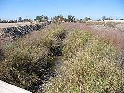 Alamo River north of Zenos Rd., near Holtville, California | |
| Countries | Mexico, United States |
|---|---|
| Source | Colorado River |
| - location | Alamo, Baja California, Mexico |
| - elevation | 36 m (118 ft) |
| - coordinates | 32°40′58″N 114°45′06″W / 32.68269°N 114.7515656°W |
| Mouth | Salton Sea |
| - elevation | −66 m (−217 ft) |
| - coordinates | 33°12′23″N 115°36′52″W / 33.206517°N 115.61433°WCoordinates: 33°12′23″N 115°36′52″W / 33.206517°N 115.61433°W |
| Length | 52 mi (84 km) [1] |
| Discharge | for Niland, about 1 mile (1.6 km) above the mouth |
| - average | 847 cu ft/s (24 m3/s) [2] |
| - max | 4,500 cu ft/s (127 m3/s) |
| - min | 288 cu ft/s (8 m3/s) |

The Alamo River flows west and north from the Mexicali Valley (Baja California) across the Imperial Valley (California). The 52-mile (84 km) long[1] river drains into the Salton Sea.
The creation of the New River, Alamo River, and Salton Sea of today started in the autumn of 1904, when the Colorado River, swollen by seasonal rainfall and snow-melt, flowed through a series of three human-engineered openings in the recently constructed levee bank of the Alamo Canal.[3] The resulting flood poured down the canal and breached an Imperial Valley dike. The sudden influx of water and the lack of any drainage from the basin resulted in the formation of the Salton Sea; the rivers had re-created a great inland sea in an area that it had frequently inundated before, the Salton Sink.
It took over two years to control the Colorado River’s inflow to the Alamo Canal and stop the uncontrolled flooding of the Salton Sink, but the canal was effectively channelized with operational headgates by the early part of 1907. The Alamo and New Rivers continued to flow, but at a lesser rate.[4]
The river was named after the Fremont cottonwood that grows in the region.[5]
In most places, the river is a vegetation-choked ravine with a small watercourse at the bottom.
References
- 1 2 "Silt Total Maximum Daily Load for the Alamo River" (PDF). State Water Resources Control Board. California Environmental Protection Agency. May 1999. Retrieved 2013-07-30.
- ↑ "USGS Gage #10254730 on the Alamo River near Niland, CA" (PDF). National Water Information System. U.S. Geological Survey. 1943–present. Retrieved 2013-07-30. Check date values in:
|date=(help) - ↑ Clarence Everett Tait (1908). Irrigation in Imperial Valley, California: its problems and possibilities. Washington Government Printing Office. pp. 13, 51. ISBN 978-1-113-10178-5. Retrieved 26 August 2010.
- ↑ Laflin, Pat. "THE SALTON SEA CALIFORNIA'S OVERLOOKED TREASURE" (PDF). Coachella Valley Historical Society. pp. 21–26. Archived from the original (PDF) on 18 November 2010. Retrieved 1 June 2010.
- ↑ William Bright; Erwin Gustav Gudde (30 November 1998). 1500 California place names: their origin and meaning. University of California Press. p. 12. ISBN 978-0-520-21271-8. Retrieved 20 January 2012.
See also
- Lake Cahuilla
- Salton Sea
- Tributaries of the Salton Sea
Colorado River system | |||||||||||||||
|---|---|---|---|---|---|---|---|---|---|---|---|---|---|---|---|
| Jurisdictions |
|     | |||||||||||||
| Canyons |
| ||||||||||||||
| Natural features |
| ||||||||||||||
| Tributaries | |||||||||||||||
| Engineering |
| ||||||||||||||
| Designated areas | |||||||||||||||
| Related topics | |||||||||||||||