Winter Gardens, California
| Winter Gardens | |
|---|---|
| census-designated place | |
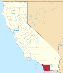
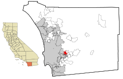 Location in San Diego County and the state of California | |
 Winter Gardens Location in the United States | |
| Coordinates: 32°50′28″N 116°55′40″W / 32.84111°N 116.92778°WCoordinates: 32°50′28″N 116°55′40″W / 32.84111°N 116.92778°W | |
| Country |
|
| State |
|
| County | San Diego |
| Area[1] | |
| • Total | 4.431 sq mi (11.475 km2) |
| • Land | 4.430 sq mi (11.472 km2) |
| • Water | 0.001 sq mi (0.003 km2) 0.02% |
| Elevation | 676 ft (206 m) |
| Population (2010) | |
| • Total | 20,631 |
| • Density | 4,700/sq mi (1,800/km2) |
| Time zone | PST (UTC-8) |
| • Summer (DST) | PDT (UTC-7) |
| ZIP code | 92040 |
| Area code(s) | 619 |
| FIPS code | 06-85992 |
| GNIS feature ID | 1656662 |
Winter Gardens is a census-designated place (CDP) in San Diego County, California. The population was 20,631 at the 2010 census, up from 19,771 at the 2000 census.
Geography
Winter Gardens is located at 32°50′28″N 116°55′40″W / 32.84111°N 116.92778°W (32.841043, -116.927747).[2]
According to the United States Census Bureau, the CDP has a total area of 4.4 square miles (11 km2), 99.98% of it land and 0.02% of it water.
Demographics
2010
The 2010 United States Census[3] reported that Winter Gardens had a population of 20,631. The population density was 4,656.5 people per square mile (1,797.9/km²). The racial makeup of Winter Gardens was 16,845 (81.6%) White, 409 (2.0%) African American, 234 (1.1%) Native American, 345 (1.7%) Asian, 95 (0.5%) Pacific Islander, 1,616 (7.8%) from other races, and 1,087 (5.3%) from two or more races. Hispanic or Latino of any race were 4,289 persons (20.8%).
The Census reported that 20,532 people (99.5% of the population) lived in households, 75 (0.4%) lived in non-institutionalized group quarters, and 24 (0.1%) were institutionalized.
There were 7,468 households, out of which 2,759 (36.9%) had children under the age of 18 living in them, 3,696 (49.5%) were opposite-sex married couples living together, 1,050 (14.1%) had a female householder with no husband present, 509 (6.8%) had a male householder with no wife present. There were 528 (7.1%) unmarried opposite-sex partnerships, and 49 (0.7%) same-sex married couples or partnerships. 1,639 households (21.9%) were made up of individuals and 516 (6.9%) had someone living alone who was 65 years of age or older. The average household size was 2.75. There were 5,255 families (70.4% of all households); the average family size was 3.20.
The population was spread out with 5,019 people (24.3%) under the age of 18, 1,996 people (9.7%) aged 18 to 24, 5,518 people (26.7%) aged 25 to 44, 5,978 people (29.0%) aged 45 to 64, and 2,120 people (10.3%) who were 65 years of age or older. The median age was 36.8 years. For every 100 females there were 97.4 males. For every 100 females age 18 and over, there were 95.4 males.
There were 7,885 housing units at an average density of 1,779.7 per square mile (687.1/km²), of which 4,264 (57.1%) were owner-occupied, and 3,204 (42.9%) were occupied by renters. The homeowner vacancy rate was 3.0%; the rental vacancy rate was 5.5%. 11,716 people (56.8% of the population) lived in owner-occupied housing units and 8,816 people (42.7%) lived in rental housing units.
2000
As of the census[4] of 2000, there were 19,771 people, 7,218 households, and 5,146 families residing in the CDP. The population density was 4,435.1 inhabitants per square mile (1,711.6/km²). There were 7,423 housing units at an average density of 1,665.1 per square mile (642.6/km²). The racial makeup of the CDP was 88.39% White, 1.30% African American, 1.00% Native American, 1.36% Asian, 0.28% Pacific Islander, 4.02% from other races, and 3.65% from two or more races. Hispanic or Latino of any race were 12.26% of the population.
There were 7,218 households out of which 35.3% had children under the age of 18 living with them, 52.7% were married couples living together, 13.3% had a female householder with no husband present, and 28.7% were non-families. 21.1% of all households were made up of individuals and 7.8% had someone living alone who was 65 years of age or older. The average household size was 2.72 and the average family size was 3.14.
In the CDP the population was spread out with 26.9% under the age of 18, 9.0% from 18 to 24, 31.3% from 25 to 44, 22.4% from 45 to 64, and 10.3% who were 65 years of age or older. The median age was 35 years. For every 100 females there were 96.6 males. For every 100 females age 18 and over, there were 94.3 males.
The median income for a household in the CDP was $45,791, and the median income for a family was $51,378. Males had a median income of $37,226 versus $29,191 for females. The per capita income for the CDP was $19,424. About 5.9% of families and 8.5% of the population were below the poverty line, including 8.8% of those under age 18 and 2.8% of those age 65 or over.
Government
In the California State Legislature, Winter Gardens is in the 38th Senate District, represented by Republican Joel Anderson, and in the 71st Assembly District, represented by Republican Randy Voepel.[5]
In the United States House of Representatives, Winter Gardens is in California's 50th congressional district, represented by Republican Duncan D. Hunter.[6]
References
- ↑ "2010 Census U.S. Gazetteer Files – Places – California". United States Census Bureau.
- ↑ "US Gazetteer files: 2010, 2000, and 1990". United States Census Bureau. 2011-02-12. Retrieved 2011-04-23.
- ↑ "2010 Census Interactive Population Search: CA - Winter Gardens CDP". U.S. Census Bureau. Retrieved July 12, 2014.
- ↑ "American FactFinder". United States Census Bureau. Retrieved 2008-01-31.
- ↑ "Statewide Database". UC Regents. Retrieved December 8, 2014.
- ↑ "California's 50th Congressional District - Representatives & District Map". Civic Impulse, LLC.