Tijuana River Estuary
| Tijuana River Estuary | |
|---|---|
|
Tijuana River Estuary | |
  Map of California | |
| Location | San Diego County, California |
| Coordinates | 32°33′24″N 117°7′34″W / 32.55667°N 117.12611°WCoordinates: 32°33′24″N 117°7′34″W / 32.55667°N 117.12611°W |
| Area | 1,569 acres (635 ha) |
| Designated | 1973 |
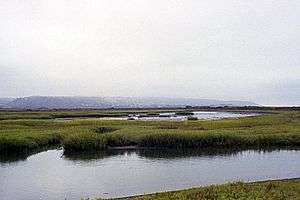
The Tijuana River Estuary is an intertidal coastal wetland at the mouth of the Tijuana River in San Diego County, California, in the United States bordering Tijuana, Baja California, Mexico. It is the location of the Tijuana River National Estuarine Research Reserve, Tijuana Slough National Wildlife Refuge, and Border Field State Park. The estuary is a shallow water habitat. Often termed an intermittent estuary since its volume is subject to the discharge controlled by the seasons of the year, the volume of the estuary fluctuates and at times there is dry land, or flooded areas.[1] It was designated a National Natural Landmark in 1973.[2]
Ecology
The estuary is one of the few remaining salt marshes on the South Coast. Its location positions it under the path of the Pacific Flyway, where it serves as a stopover point.[1] Many species of migratory and native species rely on the estuary as an essential breeding, feeding, and nesting habitat.[1] The estuary lies within the southernmost part of San Diego County within the city limits of the South Bay city of Imperial Beach.
References
- 1 2 3 "Tijuana Estuary NP". State of California. Retrieved July 8, 2011.
- ↑ "Tijuana River Estuary". nps.gov. National Park Service.