Transportation in San Diego–Tijuana
Transportation in San Diego–Tijuana occurs by various means. Though, in the four cities of San Diego, Tijuana, Tecate, and Rosarito Beach, the automobile serves as most important means of transportation.[1] The international metropolitan region maintains an intricate highway infrastructure. As a large metropolitan area in Western North America, many roadways, which consists of multiple Interstates, State Routes, and Mexican Federal Highways, hold a terminus in the area. These roads have grown accustomed to support the masses of the commuting populace within the international region and are constantly being expanded and/or renovated. Transportation is a crucial issue in the metropolitan area.[1] The streets and highways of the region effect environmental health and have influence over the degree of regional connectivity. Binational discussions about coordinating public transportation across the border are currently underway.[1] San Diego–Tijuana is the site of two major international airports and numerous regional airports. It is also the site of the Port of San Diego and miles from the nearby Port of Ensenada.
Major highways
The major freeways within the conurbation are Interstate 5, Interstate 8, Interstate 15, and Interstate 805 linking San Diego–Tijuana with regions from as far away as the Pacific Northwest, the Arizona Sun Corridor, and the Rocky Mountains; and Federal Highway 1, Federal Highway 2, and Federal Highway 3 (and corresponding toll roads for highways 1 and 2) connecting the metropolitan region to Ensenada, Baja California Sur, and the Mexicali Valley. Interstate 5 and Federal Highway 1 are critical to the North American Free Trade Agreement due to their confluence at the San Ysidro Port of Entry linking British Columbia, the West Coast of the United States and the Gold Coast of Baja California at the busiest port of entry in the world.[2] In the Imperial and Mexicali valleys, both Interstate 8 and Federal Highway 2 are connected by State Route 111 and from this junction lead to the coastal center at San Diego–Tijuana.[3] This connection ultimately links the region to the Rio Grande Valley on the Gulf of Mexico.
Within the metropolitan region, Interstate 805 is a freeway that links Tijuana to Del Mar, running through the South Bay cities of Chula Vista and National City.[4] San Diego–Tijuana is linked to Ensenada by numerous ways. These include Federal Highway 3 that runs from Tecate thru Valley of the Palms to the port city, and by way of Federal Highway 1 and Federal Highway 1D that run from Tijuana thru Rosarito Beach to the Cinderella of the Pacific.
State Routes connect regions of the metropolitan region with other California agglomerations. State Route 79 connects to the Greater Los Angeles area and State Route 78 connects to the Imperial Valley. On a regional scale State Route 52 connects communities in northern San Diego. Routes connecting Ports of Entry larger San Diego county cities, include State Route 905 connecting the Otay Mesa Port of Entry with large South Bay cities. Others such as State Route 125 link South Bay with East County. Some routes are much more extensive connecting areas such as South Bay with those as far away as the Mountain Empire as State Route 94 does.
Interstates


.svg.png) Interstate 5 - San Diego Freeway
Interstate 5 - San Diego Freeway.svg.png) Interstate 8 - Mission Valley Freeway, Ocean Beach Freeway
Interstate 8 - Mission Valley Freeway, Ocean Beach Freeway.svg.png) Interstate 15 - Escondido Freeway
Interstate 15 - Escondido Freeway.svg.png) Interstate 805 - Jacob Dekema Freeway
Interstate 805 - Jacob Dekema Freeway
California State Routes
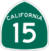 State Route 15
 State Route 52
 State Route 56
 State Route 75
 State Route 78
 State Route 79
 State Route 94
 State Route 125
 State Route 163
 State Route 905
Federal Highways
 Federal Highway 1 - Transpeninsular Highway
- Federal Highway 1D - Tijuana-Ensenada Scenic Tollway
 Federal Highway 2 - California Border Highway
 Federal Highway 3 - Tecate Federal Highway
Maritime transport
The only deepwater port in the metropolitan region is the Port of San Diego. It is one of three major ports in Southern California as well as the primary entry point for numerous automobile brands.[5][6] Carnival Cruise Lines, Royal Caribbean Cruises, and Holland America Line are among nine cruise line companies to serve the region. The cruise ships have stops in Ensenada, to the south, and in Los Angeles and Long Beach, to the north.
Marinas dot the coast line of San Diego–Tijuana. Nineteen currently exist in San Diego County.[7]
Air transport
San Diego International and Tijuana International airports service the metropolitan area. They are the major venues by which air transport occurs. Recently plans were released pertaining to the construction of binational terminal connect to Tijuana International.[8] Other airports include McClellan-Palomar Airport in Carlsbad, also slated to be the home-base of California Pacific Airlines,[9] and Oceanside Municipal Airport.
See also
References
- 1 2 3 "Quality of Life in the Greater San Diego-Tijuana-Tecate-Playas de Rosarito Region" (PDF). San Diego State University. Retrieved March 25, 2011.
- ↑ "Busiest border crossing". Interstate-Guide. Retrieved March 25, 2011.
- ↑ "San Diego-Mexicali Interstate Connection". Google. Retrieved March 25, 2011.
- ↑ "Interstate 805". Google. Retrieved March 25, 2011.
- ↑ Maritime Fact Sheet "Maritime Fact Sheet" Check
|url=value (help). Port of San Diego. Retrieved September 14, 2011. - ↑ San Diego Unified Port District Annual Report 2007, San Diego Unified Port District, 2007
- ↑ "Pacific Coast Yachts (San Diego County)". YachtWorld.com. Retrieved September 14, 2011.
- ↑ "La Plaza". Los Angeles Times.
- ↑ "California Pacific Airlines". California Pacific Airlines. Retrieved September 14, 2011.
External links
| Counties and Municipalities | 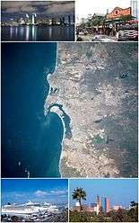 | |
|---|---|---|
| Major cities | ||
| Cities 100k - 250k | ||
| Cities and towns 20k - 99k | ||
| Cities and towns 10k-19k | ||
| Bodies of water | ||
| Sub-regions | ||
| ||