Laguna Mountains
- This article is about the mountain range in San Diego County, California. For the mountain range in southwest Arizona, see Laguna Mountains (Arizona). For the recreation area in San Benito County, California, see Laguna Mountain Recreation Area.
| Laguna Mountains | |
|---|---|
|
| |
| Highest point | |
| Peak | Cuyapaipe Mountain |
| Elevation | 1,944 m (6,378 ft) |
| Coordinates | 32°50′21″N 116°24′01″W / 32.83920°N 116.4003°W |
| Geography | |
 Location of Laguna Mountains in California [1] | |
| Country | United States |
| State | California |
| District | San Diego County |
| Range coordinates | 32°48′30″N 116°26′57″W / 32.8084°N 116.4492°WCoordinates: 32°48′30″N 116°26′57″W / 32.8084°N 116.4492°W |
| Parent range | Peninsular Ranges |
| Topo map | USGS Mount Laguna |

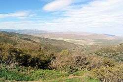
The Laguna Mountains are a mountain range of the Peninsular Ranges System, located in eastern San Diego County, southern California. The mountains run in a northwest/southeast alignment for approximately 35 miles (56 km).
The mountains have long been inhabited by the indigenous Kumeyaay people.
Geography
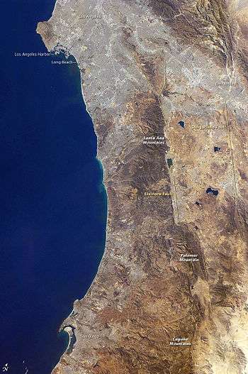
The Laguna Mountains are bordered by the Cuyamaca Mountains area on the west and the Colorado Desert on the east, where the mountains form a steep escarpment along the Laguna Salada Fault. To the north the Laguna Mountains are bounded by the Elsinore Fault Zone and to the south by Cameron Valley and Thing Valley.
The highest point is Cuyapaipe Mountain at 6,378 feet (1,944 m). The mountains are largely contained within the Cleveland National Forest. Snow falls on the highest peaks several times a year. Mount Laguna is a village in the Laguna Mountains with a population of about 80.
The headwaters of three perennial streams begin in the Laguna Mountains: Noble Creek, Cottonwood Creek, and Kitchen Creek.
The Laguna Mountains extend northwest about 35 mi (56 km) from the Mexican border at the Sierra de Juárez range.[2] The Sawtooth Range and In-Ko-Pah Mountains are adjacent to the east. The Santa Rosa Mountains lie further to the northeast. The Cuyamaca Mountains are adjacent along the west.
The southern section is in the Mountain Empire region of San Diego County, and the northern section is in the East County region.

Recreation
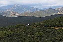
The Laguna Mountains are a popular recreation area in the Cleveland National Forest. They comprise the southernmost crest along the Pacific Crest Trail.[3]
Their relatively high altitude induces the highest snowfall in San Diego County making it one of the few local places to offer snow activities like sledding and snowshoeing.[4]
See also
- Mountain ranges of San Diego County, California
- Natural history of the Peninsular Ranges
References
- ↑ "Laguna Mountains". Geographic Names Information System. United States Geological Survey. Retrieved 2009-05-03.
- ↑ "Laguna Mountains". Columbia Gazetteer of North America. Columbia University Press. 2000. Retrieved 2008-12-14.
- ↑ "Southern California". Pacific Crest Trail Association. Retrieved 27 February 2015.
The PCT begins on a low hill near Campo (elev. 2,915′) [...] and climbs through chaparral, scrub oak and pines to the rim of the Laguna Mountains.
- ↑ "Finding Snow in San Diego". San Diego Family. December 2013. Retrieved 27 February 2015.
External links
| Wikimedia Commons has media related to Laguna Mountains (California). |