Metcalfe County, Kentucky
| Metcalfe County, Kentucky | |
|---|---|
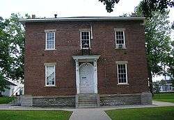 Metcalfe County courthouse in Edmonton | |
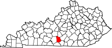 Location in the U.S. state of Kentucky | |
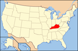 Kentucky's location in the U.S. | |
| Founded | 1860 |
| Named for | Thomas Metcalfe |
| Seat | Edmonton |
| Largest city | Edmonton |
| Area | |
| • Total | 291 sq mi (754 km2) |
| • Land | 290 sq mi (751 km2) |
| • Water | 1.5 sq mi (4 km2), 0.5% |
| Population | |
| • (2010) | 10,099 |
| • Density | 35/sq mi (14/km²) |
| Congressional district | 1st |
| Time zone | Central: UTC-6/-5 |
| Website |
www |
Metcalfe County is a county located in the U.S. state of Kentucky. As of the 2010 census, the population was 10,099.[1] Its county seat is Edmonton.[2] The county was founded in May 1860 and named for Thomas Metcalfe, Governor of Kentucky from 1828–32.[3][4] It is a prohibition or dry county. As of the uncertified vote of June 28, 2016, the county is no longer a dry county.
Metcalfe County is part of the Glasgow, KY Micropolitan Statistical Area, which is also included in the Bowling Green-Glasgow, KY Combined Statistical Area.
Geography
According to the U.S. Census Bureau, the county has a total area of 291 square miles (750 km2), of which 290 square miles (750 km2) is land and 1.5 square miles (3.9 km2) (0.5%) is water.[5]
Adjacent counties
- Hart County (northwest)
- Green County (northeast)
- Adair County (east)
- Cumberland County (southeast)
- Monroe County (south)
- Barren County (west)
Demographics
| Historical population | |||
|---|---|---|---|
| Census | Pop. | %± | |
| 1870 | 7,934 | — | |
| 1880 | 9,423 | 18.8% | |
| 1890 | 9,871 | 4.8% | |
| 1900 | 9,988 | 1.2% | |
| 1910 | 10,453 | 4.7% | |
| 1920 | 10,075 | −3.6% | |
| 1930 | 9,373 | −7.0% | |
| 1940 | 10,853 | 15.8% | |
| 1950 | 9,851 | −9.2% | |
| 1960 | 8,367 | −15.1% | |
| 1970 | 8,177 | −2.3% | |
| 1980 | 9,484 | 16.0% | |
| 1990 | 8,963 | −5.5% | |
| 2000 | 10,037 | 12.0% | |
| 2010 | 10,099 | 0.6% | |
| Est. 2015 | 9,909 | [6] | −1.9% |
| U.S. Decennial Census[7] 1790-1960[8] 1900-1990[9] 1990-2000[10] 2010-2013[1] | |||
As of the census[11] of 2000, there were 10,037 people, 4,016 households, and 2,883 families residing in the county. The population density was 34 per square mile (13/km2). There were 4,592 housing units at an average density of 16 per square mile (6.2/km2). The racial makeup of the county was 97.26% White, 1.64% Black or African American, 0.25% Native American, 0.07% Asian, 0.13% from other races, and 0.65% from two or more races. 0.53% of the population were Hispanic or Latino of any race.
There were 4,016 households out of which 32.30% had children under the age of 18 living with them, 58.10% were married couples living together, 10.00% had a female householder with no husband present, and 28.20% were non-families. 25.20% of all households were made up of individuals and 12.30% had someone living alone who was 65 years of age or older. The average household size was 2.47 and the average family size was 2.93.
In the county the population was spread out with 24.60% under the age of 18, 8.20% from 18 to 24, 28.50% from 25 to 44, 23.60% from 45 to 64, and 15.00% who were 65 years of age or older. The median age was 38 years. For every 100 females there were 95.20 males. For every 100 females age 18 and over, there were 92.60 males.
The median income for a household in the county was $23,540, and the median income for a family was $29,178. Males had a median income of $22,430 versus $18,591 for females. The per capita income for the county was $13,236. About 18.80% of families and 23.60% of the population were below the poverty line, including 29.20% of those under age 18 and 27.90% of those age 65 or over.
Communities
- Beaumont
- Center
- Edmonton (county seat)
- Knob Lick
- Randolph
- Savoyard
- Sulphur Well
- Summer Shade
- Wisdom
See also
- Dry counties
- National Register of Historic Places listings in Metcalfe County, Kentucky
- The Kentucky Headhunters, a country music/southern rock act that formed in Metcalfe County
References
- 1 2 "State & County QuickFacts". United States Census Bureau. Retrieved March 6, 2014.
- ↑ "Find a County". National Association of Counties. Retrieved 2011-06-07.
- ↑ http://www.kyenc.org/entry/m/METCA02.html
- ↑ The Register of the Kentucky State Historical Society, Volume 1. Kentucky State Historical Society. 1903. p. 36.
- ↑ "2010 Census Gazetteer Files". United States Census Bureau. August 22, 2012. Retrieved August 18, 2014.
- ↑ "County Totals Dataset: Population, Population Change and Estimated Components of Population Change: April 1, 2010 to July 1, 2015". Retrieved July 2, 2016.
- ↑ "U.S. Decennial Census". United States Census Bureau. Retrieved August 18, 2014.
- ↑ "Historical Census Browser". University of Virginia Library. Retrieved August 18, 2014.
- ↑ "Population of Counties by Decennial Census: 1900 to 1990". United States Census Bureau. Retrieved August 18, 2014.
- ↑ "Census 2000 PHC-T-4. Ranking Tables for Counties: 1990 and 2000" (PDF). United States Census Bureau. Retrieved August 18, 2014.
- ↑ "American FactFinder". United States Census Bureau. Retrieved 2008-01-31.
Municipalities and communities of Metcalfe County, Kentucky, United States | ||
|---|---|---|
| City | | |
| CDP | ||
| Other unincorporated communities | ||

Coordinates: 36°59′N 85°38′W / 36.99°N 85.63°W