Garrard County, Kentucky
| Garrard County, Kentucky | |
|---|---|
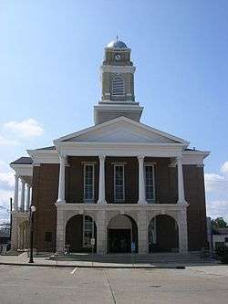 Garrard County courthouse in Lancaster | |
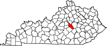 Location in the U.S. state of Kentucky | |
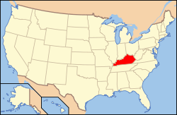 Kentucky's location in the U.S. | |
| Founded | December 17, 1796 |
| Named for | James Garrard |
| Seat | Lancaster |
| Largest city | Lancaster |
| Area | |
| • Total | 234 sq mi (606 km2) |
| • Land | 230 sq mi (596 km2) |
| • Water | 3.9 sq mi (10 km2), 1.7% |
| Population | |
| • (2010) | 16,912 |
| • Density | 74/sq mi (29/km²) |
| Congressional district | 2nd |
| Time zone | Eastern: UTC-5/-4 |
| Website |
www |
Garrard County (/ˈɡærɪd/ GAIR-id;) is a county located in the U.S. state of Kentucky. As of the 2010 census, the population was 16,912.[1] Its county seat is Lancaster.[2] The county was formed in 1796 and was named for James Garrard, Governor of Kentucky from 1796 to 1804.[3] It is a prohibition or dry county but Lancaster is wet. Lancaster was founded as a settlement of log cabins in 1776 at a springs that later provided a constant source of water to early pioneers. It is one of the oldest city's in the Commonwealth. Boonesborough, 25 miles to the east, was founded by Daniel Boone in 1775. Lexington, 28 miles to the north, was founded in 1775. Stanford, originally known as St. Asaph, is 10 miles south of Lancaster. It too was founded in 1775. The oldest permanent settlemenet in Kentucky, Harrodsburg, was founded in 1774 and is 18 miles to the west. The present day courthouse is one of the oldest courthouses in Kentucky in continuous use.
History
Garrard County was formed in 1796 from parts of Lincoln County, Madison County and Mercer County and was the 25th county of Kentucky out of 120.[4][5] It was named for Col. James Garrard, second Governor of Kentucky and acting governor at the time of the county's establishment.[6][7]
Harriet Beecher Stowe, author of Uncle Tom's Cabin, visited the Thomas Kennedy home located in the Paint Lick section of Garrard County in her only visit to the South while gathering material for the book. The cabin of the inspiration for Uncle Tom stood behind the plantation house.[8] County officials intend to recreate the slave cabin on the grounds of the Governor William Owsley House.[9]
Garrard County is historically a Whig and Republican County. Its early political leaders were outspoken supporters of Henry Clay. It was strongly pro-Union during the Civil War and has remained a Republican stronghold in the Bluegrass Region which was, until recently, largely Democratic. Histories from the Civil War era record that "On August 6, 1861, Union recruits marched into Camp Dick Robinson [in north Garrard County], making it the first Federal base south of the Ohio River. Union military figures such as Col. George C. Kniffen stated "the wisdom of President Lincoln commissioning . . .Gen. William Nelson to organize a military force on the [neutral] soil of Kentucky" prevented making the state a "battle ground for many months" and ... thereby changed the whole direction of the war. In 1864, Secretary of the Treasury Salmon P. Chase declared in a speech at Louisville "when Kentucky faltered, hesitated" in the early stages of the Civil War, that [its] undecided "status was settled by Gen. Nelson, at Camp Dick Robinson." Six years later, Indiana Senator Daniel D. Pratt reported to the U. S. Senate that Camp Dick Robinson "was one of the most noted military encampments of the war. . . . From its admirable locality and advantages, it was almost indispensable for the successful operations of the" War. Correspondence from President Lincoln indicates the Camp's importance militarily as well as sympbolically, since pro-Southern elements in Kentucky's state government urged Lincoln to close it.
Geography
According to the U.S. Census Bureau, the county has a total area of 234 square miles (610 km2), of which 230 square miles (600 km2) is land and 3.9 square miles (10 km2) (1.7%) is water.[10]
Adjacent counties
- Jessamine County (north)
- Madison County (northeast)
- Rockcastle County (southeast)
- Lincoln County (southwest)
- Boyle County (west)
- Mercer County (northwest)
Law and government
In the United States Senate, Garrard County is represented by US Senator Mitch McConnell and US Senator Rand Paul. Garrard County is in the 2nd Congressional District, represented by US Rep. Brett Guthrie; in the 22nd State Senatorial District represented by State Senator Tom Buford and in the 36th State Legislative District represented by State Representative Jonathan Shell.
Garrard County is governed by the Garrard County Fiscal Court, composed of the [County Judge Executive], who is elected county wide, and five Magistrates who are elected in magisterial districts representing different geographic areas of the county. Each member of the Fiscal Court is elected to a four-year term, pursuant to the Kentucky Constitution. The Fiscal Court is represented by the County Attorney.
- Judge Executive Hon. John Wilson (R)
- Deputy Judge Executive Hon. James Bushnell (R)
- County Attorney, Hon. Mark H. Metcalf (R)
- County Magistrates:
- Magistrate Dist. 1 Joe Leavell (R)
- Magistrate Dist. 2 Doan Adkison (R)
- Magistrate Dist. 3 Bill Warren (R)
- Magistrate Dist. 4 Bobbie Preston (R)
- Magistrate Dist. 5 Betty Von Gruenigen (R)
- County Clerk Kevin Montgomery (R)
- SheriffTim Davis (R)
- Circuit Clerk Dana Hensley (R)
- PVA Kay Hall (R)
- Jailer Kevin Middleton (R)
- Coroner Daryl Hodge (R)[11]
Popular culture
- John Michael Montgomery's 1995 hit "Sold (The Grundy County Auction Incident)" was filmed at the Garrard County Stockyards.[12]
- Portions of John Michael Montgomery's 1997 hit "I miss you a little" were filmed in Garrard County.[13]
- Portions of the 1957 movie "Raintree County" were filmed in Garrard County.
- In 2009, Garrard Economic Development Director Nathan Mick and local filmmaker Parker Young produced a short video titled: "It's Garrard County" a community effort to introduce the county to the world using new media.
Demographics
| Historical population | |||
|---|---|---|---|
| Census | Pop. | %± | |
| 1800 | 6,186 | — | |
| 1810 | 9,186 | 48.5% | |
| 1820 | 10,851 | 18.1% | |
| 1830 | 11,871 | 9.4% | |
| 1840 | 10,480 | −11.7% | |
| 1850 | 10,237 | −2.3% | |
| 1860 | 10,531 | 2.9% | |
| 1870 | 10,376 | −1.5% | |
| 1880 | 11,704 | 12.8% | |
| 1890 | 11,138 | −4.8% | |
| 1900 | 12,042 | 8.1% | |
| 1910 | 11,894 | −1.2% | |
| 1920 | 12,503 | 5.1% | |
| 1930 | 11,562 | −7.5% | |
| 1940 | 11,910 | 3.0% | |
| 1950 | 11,029 | −7.4% | |
| 1960 | 9,747 | −11.6% | |
| 1970 | 9,457 | −3.0% | |
| 1980 | 10,853 | 14.8% | |
| 1990 | 11,579 | 6.7% | |
| 2000 | 14,792 | 27.7% | |
| 2010 | 16,912 | 14.3% | |
| Est. 2015 | 17,237 | [14] | 1.9% |
| U.S. Decennial Census[15] 1790-1960[16] 1900-1990[17] 1990-2000[18] 2010-2013[1] | |||
As of the census[19] of 2000, there were 14,792 people, 5,741 households, and 4,334 families residing in the county. The population density was 64 per square mile (25/km2). There were 6,414 housing units at an average density of 28 per square mile (11/km2). The racial makeup of the county was 95.75% White, 3.06% Black or African American, 0.13% Native American, 0.04% Asian, 0.43% from other races, and 0.59% from two or more races. 1.32% of the population were Hispanic or Latino of any race.
There were 5,741 households out of which 33.40% had children under the age of 18 living with them, 62.60% were married couples living together, 9.40% had a female householder with no husband present, and 24.50% were non-families. 21.10% of all households were made up of individuals and 9.50% had someone living alone who was 65 years of age or older. The average household size was 2.56 and the average family size was 2.95.
By age, 24.40% of the population was under 18, 8.10% from 18 to 24, 30.90% from 25 to 44, 23.60% from 45 to 64, and 13.00% were 65 or older. The median age was 37 years. For every 100 females there were 96.80 males. For every 100 females age 18 and over, there were 93.00 males.
The median income for a household in the county was $34,284, and the median income for a family was $41,250. Males had a median income of $30,989 versus $21,856 for females. The per capita income for the county was $16,915. About 11.60% of families and 14.70% of the population were below the poverty line, including 19.10% of those under age 18 and 17.00% of those age 65 or over.
Politics
| Year | Republican | Democrat |
|---|---|---|
| 2012 | 75.03% 5,310 | 23.47% 1,661 |
| 2008 | 70.98% 5,118 | 27.91% 2,012 |
| 2004 | 71.85% 4,784 | 27.65% 1,841 |
| 2000 | 69.43% 4,043 | 29.42% 1,713 |
Communities
- Bryantsville
- Buckeye
- Cartersville
- Davis Town
- Hyattsville
- Lancaster (county seat)
- Paint Lick
Notable residents
- Simeon H. Anderson (1802–1840) was a United States Representative from Kentucky.
- John Boyle (1774–1834) was a member of the U.S. House of Representatives and Chief Justice of the Kentucky Court of Appeals. He was one of Kentucky's earliest federal judges. Boyle County is named for him.
- William O. Bradley (1847–1914) was an American politician, the first Republican governor of Kentucky, and later served as the second Republican U.S. senator from Kentucky. By age 14, he had twice run away from his home in Lancaster to join the Union Army in Somerset, Kentucky. With his parents' permission, he joined the Army at age 16 in 1863 and served in the ranks through the end of the war. He was a staunch abolitionist and made solid improvements in the civic life of black Kentuckians, assuring them of voting protections and appointing several to positions of influence in state government. He was an early supporter of Theodore Roosevelt for the U.S. presidency. In his first race for governor, Bradley reminded voters that his Democrat opponent, Simon Bolivar Buckner, had served as a general for the Confederate States Army and that Buckner had sought to separate Kentucky from the Union.
- Kenny Davis (1949-) A Georgetown College basketball standout, Kenneth "Kenny" Davis was selected to the 1972 U.S. Olympic Basketball Team that played in the "Munich Games."
- Bradley Kincaid (1895–1989) "The Kentucky Mountain Boy," was radio's pioneer singer of folk songs and ballads in the 1920s-40s. His radio program "The WLS Barn Dance" was broadcast by WLS Radio in Chicago, Illinois. He was the first major country music star in the U.S.
- Robert P. Letcher(1788–1861) was an American politician, a Whig and close ally of Henry Clay, who served as a U.S. Representative, diplomat and governor of Kentucky. Letcher County, Kentucky is named in his honor. His statue stands outside the Garrard Justice Center.
- Eddie Montgomery (1963 - ) is a member of American country music duo Montgomery Gentry and brother of John Michael Montgomery was raised in Garrard County.
- John Michael Montgomery (1965- ) is an American country music artist, born and raised in Garrard County. He is the brother of Eddie Montgomery.
- Carrie (or Carry) Amelia Nation (1846–1911) founded the Women's Christian Temperance Union (WCTU), a movement that opposed alcohol in pre-Prohibition America.Her maiden name was Carrie A. Nation. She frequently reminded audiences of this as she campaigned against alcohol.[21]
- Jody Payne Guitarist who played with American country music star Willie Nelson for 34 years and retired in 2008.[22]
- Cicero Price (1805-1888) was a United States Navy commodore who fought in the American Civil War and was commander of the East India Squadron.
- William Owsley (1782–1862) was an American politician, a Whig and Kentucky Court of Appeals judge, who became the sixteenth Governor of Kentucky. His home, Pleasant Retreat, still stands on the southern end of Lancaster. He was a respected figure in law as well as politics. Owsley County, Kentucky is named in his honor.
- Henry Smith (1788–1851) is known as the first American-born governor of Texas, serving during the Texas revolution and through the battles of the Alamo, Goliad, and San Jacinto. Though defeated for the Texas presidency in 1836 by Sam Houston, Smith later accepted appointment from Houston as the first Treasury Secretary of the Republic of Texas. In 1840, he was elected to the 5th Congress of the Texas Republic. His portrait hangs in the Texas State Capitol. He was born in Garrard County in 1788 and raised there to adulthood. He later established a gold mining camp in Los Angeles, California and was buried there by his sons. At the time of the dedication of his portrait in the Capitol, his tribute declared that "California stands vigil over his dust and Texas is guardian of his fame."
See also
- National Register of Historic Places listings in Garrard County, Kentucky
- Garrard County High School
References
- 1 2 "State & County QuickFacts". United States Census Bureau. Retrieved March 6, 2014.
- ↑ "Find a County". National Association of Counties. Retrieved 2011-06-07.
- ↑ "Garrard County". The Kentucky Encyclopedia. 2000. Retrieved August 21, 2014.
- ↑ Rennick, Robert M. (1987). Kentucky Place Names. University Press of Kentucky. p. 114. Retrieved 2013-04-28.
- ↑ Collins, Lewis (1882). Collins' Historical Sketches of Kentucky: History of Kentucky, Volume 2. Collins & Company. p. 26.
- ↑ The Register of the Kentucky State Historical Society, Volume 1. Kentucky State Historical Society. 1903. p. 35.
- ↑ Gannett, Henry (1905). The Origin of Certain Place Names in the United States. Govt. Print. Off. p. 135.
- ↑ "Highway Marker: Birthplace of Carry A. Nation". Kentucky Historical Society. Retrieved 2009-05-07.
- ↑ Cox, Charlie (2008-05-29). "Garrard proceeds with Uncle Tom's Cabin". The Advocate Messenger. Retrieved 2009-10-07.
- ↑ "2010 Census Gazetteer Files". United States Census Bureau. August 22, 2012. Retrieved August 14, 2014.
- ↑ "Kentucky: Garrard County - County Overview". Garrardcounty.ky.gov. January 14, 2013. Retrieved June 7, 2013.
- ↑ Stephenson, David (2007-06-13). "Garrard Stockyards Prepares to Close". Lexington Herald Leader. Retrieved 2009-10-07.
- ↑ "Barbara Montgomery v John Michael Montgomery, Atlantic Records Corporation, and Maureen Ryan". Supreme Court of Kentucky. 2001-11-21. Retrieved 2009-10-07.
- ↑ "County Totals Dataset: Population, Population Change and Estimated Components of Population Change: April 1, 2010 to July 1, 2015". Retrieved July 2, 2016.
- ↑ "U.S. Decennial Census". United States Census Bureau. Retrieved August 14, 2014.
- ↑ "Historical Census Browser". University of Virginia Library. Retrieved August 14, 2014.
- ↑ "Population of Counties by Decennial Census: 1900 to 1990". United States Census Bureau. Retrieved August 14, 2014.
- ↑ "Census 2000 PHC-T-4. Ranking Tables for Counties: 1990 and 2000" (PDF). United States Census Bureau. Retrieved August 14, 2014.
- ↑ "American FactFinder". United States Census Bureau. Retrieved 2008-01-31.
- ↑ "Dave Leip's Atlas of U.S. Presidential Elections". Retrieved 2016-07-31.
- ↑ "Carry A. Nation (1846 – 1911)". The State Historical Society of Missouri. Retrieved 6 April 2014.
- ↑ http://www.courier-journal.com/article/20110322/SCENE04/303220032/1031/SPORTS05/Mickey-Raphael-loves-being-part-Willie-Nelson-s-Family?odyssey=nav%7Chead
External links
Municipalities and communities of Garrard County, Kentucky, United States | ||
|---|---|---|
| City | | |
| Unincorporated communities | ||

Coordinates: 37°39′N 84°32′W / 37.65°N 84.54°W