Shelby County, Kentucky
| Shelby County, Kentucky | ||
|---|---|---|
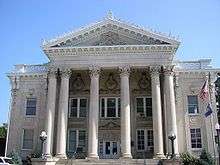 Former Shelby County courthouse in Shelbyville | ||
| ||
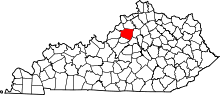 Location in the U.S. state of Kentucky | ||
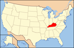 Kentucky's location in the U.S. | ||
| Founded | 1792 | |
| Named for | Isaac Shelby | |
| Seat | Shelbyville | |
| Largest city | Shelbyville | |
| Area | ||
| • Total | 386 sq mi (1,000 km2) | |
| • Land | 380 sq mi (984 km2) | |
| • Water | 6.0 sq mi (16 km2), 1.6% | |
| Population | ||
| • (2010) | 42,074 | |
| • Density | 111/sq mi (43/km²) | |
| Congressional district | 4th | |
| Time zone | Eastern: UTC-5/-4 | |
| Website |
www | |

Shelby County is a county located in the U.S. state of Kentucky. As of the 2010 census, the population was 42,074.[1] The county seat is Shelbyville.[2] The county was founded in 1792[3] and named for Isaac Shelby, the first Governor of Kentucky.[4]
Shelby County is part of the Louisville/Jefferson County, KY–IN Metropolitan Statistical Area.
Shelby County was historically a prohibition or completely dry county, but the city of Shelbyville is now wet (i.e., allows retail alcohol sales), and the county has voted to allow restaurants outside Shelbyville to sell alcoholic beverages by the drink if they seat at least 100 patrons and derive at least 70% of their total sales from food. Today, Shelby County is officially classified by the Kentucky Office of Alcoholic Beverage Control as a moist county.[5]
Shelby County's motto is "Good Land, Good Living, Good People".
History
Shelby County was established in 1792 from land given by Jefferson County.[6]
Founding families
One of the earliest families to settle in Shelby County was that of Daniel Ketcham of Washington County, Maryland. Ketcham, who arrived in 1784, had been a soldier in the American Revolution. He had 9 children. His oldest, John Ketcham, moved to Indiana, become involved in politics, and laid the groundwork for the creation of Indiana University.
Another early settler was Thomas Mitchell, who also moved to Shelby County in 1784. Mitchell was born on December 16, 1777, in Augusta County, Virginia. He married Rebecca Ketcham, daughter of Daniel Ketcham, and settled near the headwaters of South Fork Clear Creek (or Mulberry Creek). Mitchell was commissioned an ensign in the 18th Regiment of Militia and on January 4, 1801, Governor James Garrard became a captain in the 18th Regiment. Mitchell was a minister of the Methodist Church and served in the War of 1812.[7]
Geography
According to the U.S. Census Bureau, the county has a total area of 386 square miles (1,000 km2), of which 380 square miles (980 km2) is land and 6.0 square miles (16 km2) (1.6%) is water.[8] Jeptha Knob at 1,188 feet (362 m) is the highest point in the Louisville area. Guist Creek Lake and Marina offers 325 acres of fishing.[9]
Adjacent counties
- Henry County (north)
- Franklin County (east)
- Anderson County (southeast)
- Spencer County (southwest)
- Jefferson County (west)
- Oldham County (northwest)
Major highways
Demographics
| Historical population | |||
|---|---|---|---|
| Census | Pop. | %± | |
| 1800 | 8,191 | — | |
| 1810 | 14,877 | 81.6% | |
| 1820 | 21,047 | 41.5% | |
| 1830 | 19,030 | −9.6% | |
| 1840 | 17,768 | −6.6% | |
| 1850 | 17,095 | −3.8% | |
| 1860 | 16,433 | −3.9% | |
| 1870 | 15,733 | −4.3% | |
| 1880 | 16,813 | 6.9% | |
| 1890 | 16,521 | −1.7% | |
| 1900 | 18,340 | 11.0% | |
| 1910 | 18,041 | −1.6% | |
| 1920 | 18,532 | 2.7% | |
| 1930 | 17,679 | −4.6% | |
| 1940 | 17,759 | 0.5% | |
| 1950 | 17,912 | 0.9% | |
| 1960 | 18,493 | 3.2% | |
| 1970 | 18,999 | 2.7% | |
| 1980 | 23,328 | 22.8% | |
| 1990 | 24,824 | 6.4% | |
| 2000 | 33,337 | 34.3% | |
| 2010 | 42,074 | 26.2% | |
| Est. 2015 | 45,632 | [10] | 8.5% |
| U.S. Decennial Census[11] 1790-1960[12] 1900-1990[13] 1990-2000[14] 2010-2013[1] | |||
As of the census[15] of 2000, there were 33,337 people, 12,104 households, and 9,126 families residing in the county. The population density was 87 per square mile (34/km2). There were 12,857 housing units at an average density of 34 per square mile (13/km2). The racial makeup of the county was 86.61% White, 8.83% Black or African American, 0.30% Native American, 0.40% Asian, 0.12% Pacific Islander, 2.39% from other races, and 1.34% from two or more races. 4.51% of the population were Hispanic or Latino of any race.
There were 12,104 households out of which 34.70% had children under the age of 18 living with them, 61.00% were married couples living together, 10.60% had a female householder with no husband present, and 24.60% were non-families. 20.20% of all households were made up of individuals and 8.00% had someone living alone who was 65 years of age or older. The average household size was 2.63 and the average family size was 3.00.
The age distribution was 25.20% under the age of 18, 8.70% from 18 to 24, 31.40% from 25 to 44, 24.00% from 45 to 64, and 10.80% who were 65 years of age or older. The median age was 36 years. For every 100 females there were 94.90 males. For every 100 females age 18 and over, there were 91.30 males.
The median income for a household in the county was $45,534, and the median income for a family was $52,764. Males had a median income of $35,484 versus $25,492 for females. The per capita income for the county was $20,195. About 6.50% of families and 9.90% of the population were below the poverty line, including 11.70% of those under age 18 and 12.30% of those age 65 or over.
Education
Shelby County Public Schools has six elementary schools, two middle schools, and two high schools. James Neihof is the Superintendent of Schools.[16]
Schools located in Shelby County include:
Elementary Schools
- Clear Creek Elementary School
- Heritage Elementary School
- Painted Stone Elementary School
- Simpsonville Elementary School
- Southside Elementary School
- Wright Elementary School
Middle Schools
- Shelby County East Middle School
- Shelby County West Middle School
High Schools:
Communities
See also
- Dry county
- Louisville–Elizabethtown–Scottsburg, KY–IN Combined Statistical Area
- National Register of Historic Places listings in Shelby County, Kentucky
- Outlet Shoppes of the Bluegrass
Resources
- "Excerpts from the Executive Journal of Governor James Garrod," Kentucky Historical Society Register, vol. 32, p. 133.
- Woodfill, Gabriel, "A Preacher of the Gospel," Marriage Bonds of Shelby County - 1792-1800, Kentucky Marriage Records: From the Register of the Kentucky Historical Society, Baltimore 1983, p. 693.
- Willis, George L. Sr., History of Shelby County Kentucky, Shelbyville 1929, p. 115.
References
- 1 2 "State & County QuickFacts". United States Census Bureau. Retrieved March 6, 2014.
- ↑ "Find a County". National Association of Counties. Retrieved 2011-06-07.
- ↑ http://www.kyenc.org/entry/s/SHELB04.html
- ↑ The Register of the Kentucky State Historical Society, Volume 1. Kentucky State Historical Society. 1903. p. 37.
- ↑ "Wet & Dry Counties in Kentucky" (PDF). Kentucky Office of Alcoholic Beverage Control. Retrieved March 21, 2007.
- ↑ Collins, Lewis (1882). Collins' Historical Sketches of Kentucky: History of Kentucky, Volume 2. Collins & Company. p. 26.
- ↑ . (1904-07-20). "MITCHELL FAMILY HISTORY in Virginia and Kentucky". Iamonia.tripod.com. Retrieved 2010-07-30.
- ↑ "2010 Census Gazetteer Files". United States Census Bureau. August 22, 2012. Retrieved August 20, 2014.
- ↑ Welcome to Shelby County Kentucky, Shelby County Kentucky Website
- ↑ "County Totals Dataset: Population, Population Change and Estimated Components of Population Change: April 1, 2010 to July 1, 2015". Retrieved July 2, 2016.
- ↑ "U.S. Decennial Census". United States Census Bureau. Retrieved August 20, 2014.
- ↑ "Historical Census Browser". University of Virginia Library. Retrieved August 20, 2014.
- ↑ "Population of Counties by Decennial Census: 1900 to 1990". United States Census Bureau. Retrieved August 20, 2014.
- ↑ "Census 2000 PHC-T-4. Ranking Tables for Counties: 1990 and 2000" (PDF). United States Census Bureau. Retrieved August 20, 2014.
- ↑ "American FactFinder". United States Census Bureau. Retrieved 2008-01-31.
- ↑ http://www.shelby.kyschools.us/images/PDF/Neihof_philosophy_2011.pdf
External links
Municipalities and communities of Shelby County, Kentucky, United States | ||
|---|---|---|
| Cities | | |
| Unincorporated communities | ||
| Footnotes | ‡This populated place also has portions in an adjacent county or counties | |

Coordinates: 38°13′N 85°11′W / 38.22°N 85.19°W