Grahn, Kentucky
| Grahn, Kentucky | |
|---|---|
| Unincorporated community | |
 Grahn  Grahn Location within the state of Kentucky | |
| Coordinates: 38°17′1″N 83°4′31″W / 38.28361°N 83.07528°WCoordinates: 38°17′1″N 83°4′31″W / 38.28361°N 83.07528°W | |
| Country | United States |
| State | Kentucky |
| County | Carter |
| Elevation | 692 ft (211 m) |
| Time zone | Eastern (EST) (UTC-5) |
| • Summer (DST) | EDT (UTC-4) |
| ZIP codes | 41142 |
| GNIS feature ID | 493087 |
Grahn is an unincorporated community in Carter County, Kentucky, United States. It lies along Route 182, east of Olive Hill and southwest of the county seat of Grayson.[1] Its elevation is 692 feet (211 m).[2] Although it is unincorporated, it has a post office, with the ZIP code of 41142.[3] The ZCTA for ZIP code 41142 had a population of 95 at the 2000 census.[4]
A post office was established in the community in 1888 as Fireclay. In 1909, it was renamed Grahn in honor of the German immigrant Karl Bernhard Grahn, founder of a successful brickyard.[5]
A school was constructed in Grahn in the 1930s under the direction of the WPA.[6] This building was originally Grahn High School; later it became Grahn Elementary School. When the school was closed in 1994, residents of the area sought to purchase the building and renovate it into a community center. After a grant was received in 1997, the Grahn School Community Center opened to provide services for people in Grahn and the surrounding area, including a library, thrift store, sports facilities and computer classes.[7]
References
- ↑ Rand McNally. The Road Atlas '09. Chicago: Rand McNally, 2009, p. 43.
- ↑ U.S. Geological Survey Geographic Names Information System: Grahn, Kentucky
- ↑ Zip Code Lookup
- ↑ "American FactFinder". United States Census Bureau. Retrieved 2008-01-31.
- ↑ Rennick, Robert M. (1987). Kentucky Place Names. University Press of Kentucky. p. 121. Retrieved 2013-04-28.
- ↑ "Clay's Choice, Carter County" Kentucky Quilt Trail. Retrieved 2 April 2009.
- ↑ Grahn School Community Center Retrieved 1 April 2009.
Municipalities and communities of Carter County, Kentucky, United States | ||
|---|---|---|
| Cities | 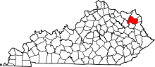 | |
| Unincorporated communities | ||
| Footnotes | ‡This populated place also has portions in an adjacent county or counties | |