La Trinidad, Benguet
| La Trinidad | ||
|---|---|---|
| Municipality | ||
|
La Trinidad strawberry fields | ||
| ||
|
Nickname(s): Strawberry Capital of the Philippines Rose Capital of the Philippines[1] | ||
 Location in the province of Benguet | ||
.svg.png) La Trinidad Location within the Philippines | ||
| Coordinates: 16°22′N 120°41′E / 16.37°N 120.68°ECoordinates: 16°22′N 120°41′E / 16.37°N 120.68°E | ||
| Country | Philippines | |
| Region | Cordillera Administrative Region (CAR) | |
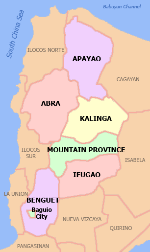
| Province | Benguet | |
| District | Lone district of Benguet | |
| Founded | 1950 | |
| Barangays | 16 | |
| Government | ||
| • Mayor | Edna Cuyopan Tabanda | |
| Area[2] | ||
| • Total | 70.04 km2 (27.04 sq mi) | |
| Population (2015 census)[3] | ||
| • Total | 129,133 | |
| • Density | 1,800/km2 (4,800/sq mi) | |
| Time zone | PST (UTC+8) | |
| ZIP code | 2601 | |
| Dialing code | +63 (0)74 | |
| Income class | 1st class | |
| Website |
www | |


La Trinidad (Ilocano: Ili ti La Trinidad) is a first class[2] and capital municipality of the province of Benguet, Philippines. According to the 2015 census, it has a population of 129,133 people.[3]
The municipality is known for its strawberry and vegetable plantations earning the town the title "Strawberry Capital of the Philippines".[1][4] The town currently holds the Guinness World Record for baking the world's largest strawberry shortcake in March 20, 2004.[5]
History
Pre-colonial and Spanish periods
The valley encompassing La Trinidad was originally called "Benguet", a thriving community of Ibaloi migrants from Tinek. Colonial influence reached the area upon Spanish explorers Don M. Quirante's discovery of the valley in 1642, and Lt. Col. Guillermo Galvey's expedition to Benguet in 1829.[1]
The valley was later renamed to "La Trinidad" in honor of Galvey's wife.[6] Together with 40 other smaller surrounding rancherías, La Trinidad was placed under the jurisdiction of the newly established Benguet commandancia politico-militar in 1846.[7][8] La Trinidad was established as the administrative headquarters of the Benguet commandancia during the Spanish Conquest of the Philippines.[1][6][9]
American period
With the establishment of Benguet as a province under the Republic of the Philippines in 1899, La Trinidad was made as its capital.[1]
In 1900, the American colonizers arrived, and La Trinidad was established as one of the 19 townships under Benguet province, upon the issuance of Act No. 48.[6][10] For a brief period, Baguio became the capital of Benguet when appointed Benguet province civil governor H.P. Whitmarsh moved the capital from La Trinidad to Baguio in 1901. La Trinidad was made the provincial capital again in 1909, after the Baguio township was abolished and converted into a chartered city.[1]
Second World War
In 1942, Japanese soldiers occupied La Trinidad, Benguet.
On May 3, 1945, The Filipino soldiers of the 2nd, 11th, 12th, 13th, 15th and 16th Infantry Division of the Philippine Commonwealth Army, 1st Infantry Regiment of the Philippine Constabulary, and the 66th Infantry Regiment of the United States Armed Forces in the Philippines - Northern Luzon or USAFIP-NL liberated La Trinidad.[1]
Modern history
La Trinidad was transformed into a full-fledged town from its former status as municipal district by virtue of Republic Act No. 531, approved June 16, 1950.[11]
The town landed on the Guinness Book of World Records for baking the world's largest strawberry shortcake, at 21,213.40 lb (9,622.23 kg), at the La Trinidad Strawberry Festival on March 20, 2004.[5]
In March 2015, 6,000 slices of strawberry cake were served as part of the events at this municipality's Strawberry Festival.[12] The cakes for the slices were prepared using fresh strawberries.[12]
On June 23, 2016, La Trinidad was highlighted in the media when the first and largest community artwork in the Philippines, the STOBOSA Hillside Homes Artwork was unveiled, featuring hillside houses within the sitios of Stonehill, Botiwtiw and Sadjap of Barangay Balili painted with sunflower and abstract designs.[13][14]
Geography
La Trinidad is bounded by Tublay on the north-east, Sablan on the west, Baguio City on the south, Itogon on the southeast, and Tuba on the south-west.
The municipality has a land area of 7,004 hectares (17,310 acres),[2] representing 3.16% of the provincial land area. The terrain is generally mountainous with springs, rivers and creeks. The town has a valley which encompasses several barangays. The valley floor elevation is at 1,300 metres (4,300 ft) above sea level. Elevation ranges from 500 to 1,700 metres (1,600 to 5,600 ft) above sea level.
Balili River is the municipality's main water drainage which carries upstream water from Sagudin River in Baguio City.[15] The river merges with another upstream river in Tuel upon reaching the La Trinidad-Tublay-Sablan tri-point.
Barangays
There are 16 barangays in La Trinidad, with 11 being classified as urban and 5 as rural.[16] The most populous is Pico with 23,282 people as of the 2015 Census, and Bineng, with 1,624 people, having the least.[3] Wangal is the largest in terms of land area,[17] while Cruz is the smallest.[18] Balili was the most densely populated, and Bineng was the least. Bineng has the most number of sitios, while Betag has the least with only 4.
| |||||||||||||||||||||||||||||||||||||||||||||||||||||||||||||||||||||||||||||||||||||||||||||||||||||||||||||||||||||||||||||||||||||||||||||||||||||||||||||||||||||||||||||||||||||||||||||||||||||||||||||||
Climate
La Trinidad belongs under the Type I climate by the Coronas System of classification with distinct wet and dry seasons. The dry season is from November to April while the wet season occurs during the rest of the year. The climate is cool with temperatures ranging from 11.7 °C (53.1 °F) during the month of December at its coldest and 23.2 °C (73.8 °F) at its warmest during the months of March, April and May. The average daily temperature is 18.55 °C (65.39 °F). Wind velocity is 1.43. During the rainiest month of August, the rainfall average is 850.70 millimetres (33.492 in).
Demographics
| Population census of La Trinidad | |||||||||||||||||||||||||
|---|---|---|---|---|---|---|---|---|---|---|---|---|---|---|---|---|---|---|---|---|---|---|---|---|---|
|
| ||||||||||||||||||||||||
| Source: Philippine Statistics Authority[3][19][34][35] | |||||||||||||||||||||||||
The population of La Trinidad, Benguet, in the 2015 census was 129,133 people,[3] with a density of 1,800 inhabitants per square kilometre or 4,700 inhabitants per square mile.
Economy
.jpg)
La Trinidad supplies most of the Philippines' strawberries[36] and cut flowers which include roses.[37][38][39] The La Trinidad Vegetable Trading Post is visited by wholesalers and traders of vegetables from other provinces.[40] The presence of the Benguet State University in the municipality serves as a boost to agricultural research and development in the region.[41]
Its proximity to the city of Baguio attracts tourists, primarily to the strawberry fields in the valley, and lesser to the Benguet Provincial Capitol and the Rose Gardens of barangay Bahong.[42]
Education
La Trinidad, aside from the adjacent city of Baguio, is the center of higher education in Benguet province.[43]
Public schools
As of 2014, La Trinidad has 23 public elementary schools and 7 public secondary schools.[44][45][46]
The main campus of the Benguet State University, the first university in the province, is located in the municipality.
|
|
Private schools
- BVS Colleges - Formerly Benguet Vocational school Colleges
- Cordillera Career Development College - the first private tertiary school in the BIMAK (Benguet, Ifugao, Mt. Province, Apayao, Kalinga) region, excluding Baguio City
- Epiphany Learning Center
- Globalight Vision School
- H.O.P.E. Christian Academy, established in 1997
- King's College of the Philippines
- Little Flower Children's Home Foundation
- Northskills Polytechnic College Incorporated (also known as Full Bright Preparatory School), established in 2003
- Philippine Nazarene College - formerly known as Luzon Nazarene Bible College (LNBC), established in 1952
- Rainbow Mission International Academy, established in 1998
- San Jose School of La Trinidad, Inc.
- Star Colleges - Formerly Twinkle Star School
- The Montessori Academy
Notable people
La Trinidad is the burial place of:
- Deodato Arellano (1844–1899), a Filipino patriot and one of the founders of the Katipunan.
References
- 1 2 3 4 5 6 7 "Municipality of La Trinidad, Benguet". DILG-CAR. Retrieved 18 September 2014.
- 1 2 3 "Province: Benguet". PSGC Interactive. Makati City, Philippines: National Statistical Coordination Board. Retrieved 12 August 2013.
- 1 2 3 4 5 6 "CORDILLERA ADMINISTRATIVE REGION (CAR)". Census of Population (2015): Total Population by Province, City, Municipality and Barangay (Report). PSA. Retrieved 20 June 2016.
- ↑ "Cordillera Autonomous Region". It's More Fun in the Philippines. Retrieved 18 September 2014.
- 1 2 "Largest fruit shortcake". Guinness World Records. Retrieved 6 January 2015.
- 1 2 3 "Facts & Figures: Benguet Province". Philippine Statistics Authority - National Statistical Coordination Board - Cordillera Administrative Region. NSCB. 23 April 2012. Retrieved 6 October 2014.
- ↑ Lancion, Jr., Conrado M.; de Guzman, Rey (cartography) (1995). "The Provinces". Fast Facts about Philippine Provinces (The 2000 Millenium ed.). Makati, Metro Manila: Tahanan Books. p. 38. ISBN 971-630-037-9. Retrieved 16 January 2015.
- ↑ "History of Takdian (La Trinidad)". Province of Benguet (official website). Retrieved 6 October 2014.
- ↑ "Profile of La Trinidad: LA TRINIDAD THROUGH THE YEARS". Retrieved 16 September 2014.
- ↑ "History: Benguet Province". Province of Benguet (official website). Retrieved 9 October 2014.
- ↑ "Republic Act No. 531: An Act to Convert the Municipal District of La Trinidad, Subprovince of Benguet, Mountain Province, into a Regular Municipality to be Known as the Municipality of La Trinidad". PhilippineLaw.info. Retrieved 2011-04-09.
- 1 2 Locsin, Joel (August 10, 2015). "Get ready for 6,000 slices of strawberry cake in Benguet". GMA News. Retrieved December 2, 2015.
- ↑ "La Trinidad residents create first, biggest community artwork in the Philippines". The Philippine Star. 24 June 2016. Archived from the original on 25 June 2016. Retrieved 30 October 2016.
- ↑ Lapniten, Karl (23 June 2016). "Artists turn Benguet hillside homes into mural". CNN Philippines. Archived from the original on 28 June 2016. Retrieved 30 October 2016.
- ↑ Susan Aro (11 October 2011). "Balili River wanting for clean, safe waters". Sun.Star Baguio. Sun.Star Baguio. Retrieved 16 September 2014.
- 1 2 3 "Municipality/City: LA TRINIDAD (Capital)". PSGC Interactive; Philippine Standard Geographic Code. Philippine Statistics Authority - National Statistical Coordination Board. Retrieved 1 November 2015.
- 1 2 3 4 "Barangay Wangal" (web page and PDF). Municipality of La Trinidad. 2015. Retrieved 1 November 2015.
- 1 2 3 4 5 "Barangay Cruz" (web page and PDF). Municipality of La Trinidad. 2015. Retrieved 1 November 2015.
- 1 2 "CORDILLERA ADMINISTRATIVE REGION (CAR)". Census of Population and Housing (2010): Total Population by Province, City, Municipality and Barangay (Report). NSO. Retrieved 29 June 2016.
- 1 2 3 4 "Barangay Alapang" (web page and PDF). Municipality of La Trinidad. 2015. Retrieved 1 November 2015.
- 1 2 3 4 "Barangay Alno" (web page and PDF). Municipality of La Trinidad. 2015. Retrieved 1 November 2015.
- 1 2 3 4 "Barangay Ambiong" (web page and PDF). Municipality of La Trinidad. 2015. Retrieved 1 November 2015.
- 1 2 3 4 "Barangay Bahong" (web page and PDF). Municipality of La Trinidad. 2015. Retrieved 1 November 2015.
- 1 2 3 4 "Barangay Balili" (web page and PDF). Municipality of La Trinidad. 2015. Retrieved 1 November 2015.
- 1 2 3 "Barangay Beckel" (web page and PDF). Municipality of La Trinidad. 2015. Retrieved 1 November 2015.
- 1 2 3 4 "Barangay Bineng" (web page and PDF). Municipality of La Trinidad. 2015. Retrieved 1 November 2015.
- 1 2 3 4 "Barangay Betag" (web page and PDF). Municipality of La Trinidad. 2015. Retrieved 1 November 2015.
- 1 2 3 4 "Barangay Lubas" (web page and PDF). Municipality of La Trinidad. 2015. Retrieved 1 November 2015.
- 1 2 3 "Barangay Pico" (web page and PDF). Municipality of La Trinidad. 2015. Retrieved 1 November 2015.
- 1 2 3 4 "Barangay Poblacion" (web page and PDF). Municipality of La Trinidad. 2015. Retrieved 1 November 2015.
- 1 2 3 "Barangay Puguis" (web page and PDF). Municipality of La Trinidad. 2015. Retrieved 1 November 2015.
- 1 2 3 4 "Barangay Shilan" (web page and PDF). Municipality of La Trinidad. 2015. Retrieved 1 November 2015.
- 1 2 3 4 "Barangay Tawang" (web page and PDF). Municipality of La Trinidad. 2015. Retrieved 1 November 2015.
- ↑ "CORDILLERA ADMINISTRATIVE REGION (CAR)". Census of Population (1995, 2000 and 2007): Total Population by Province, City and Municipality (Report). NSO. Archived from the original on 24 June 2011.
- ↑ "Province of Benguet". Municipality Population Data. LWUA Research Division. Retrieved 12 August 2013.
- ↑ Caluza, Desiree (27 April 2013). "What is life without strawberry in La Trinidad Valley?". Philippine Daily Inquirer. Retrieved 5 January 2015.
- ↑ Catajan, Maria Elena (13 February 2014). "Benguet blooms in focus". Sun.Star Baguio. Retrieved 6 October 2014.
- ↑ Rillorta, Paul (22 March 2012). "City supports La Trinidad strawberry festival –mayor". Official website of the City Government of Baguio. Retrieved 5 January 2015.
- ↑ Agreda, JM (13 March 2014). "La Trinidad hopes strawberries will draw tourists". 9News Philippines. Retrieved 6 October 2014.
- ↑ Obnial, Angela (December 2005). "La Trinidad veggie trading post revisited". Bureau of Agricultural Research Chronicle. Retrieved 6 October 2014.
- ↑ Dumlao, Artemio (11 July 2013). "Benguet State U starts developing organic agri program". The Philippine Star. Retrieved 6 October 2014.
- ↑ Lago, Amanda (9 April 2012). "Benguet roses now a summer attraction". GMA News. Retrieved 6 October 2014.
- ↑ "La Trinidad Now Rivals Baguio as Educational Center". Joseph. Goshen Land. 11 June 2015. Retrieved 22 July 2016.
- ↑ "Masterlist of Public Elementary Schools for the School year 2012- 2013" (XLSX). Department of Education (Philippines), July 15, 2013. Retrieved 28 December 2014.
- 1 2 "Masterlist of Secondary Schools (School Year 2013- 2014)" (XLSX). Department of Education (Philippines), July 4, 2013. Retrieved 20 November 2014.
- 1 2 "Masterlist of Public Schools SY 2013-2014" (XLSX). Department of Education (Philippines), 22 October 2014. Retrieved 28 December 2014.
External links
| Wikimedia Commons has media related to La Trinidad, Benguet. |
- Municipality of La Trinidad (official website)
- Department of Interior and Local Government
- Province of Benguet - La Trinidad
- Philippine Standard Geographic Code
- Philippine Census Information
 |
Tublay | | ||
| Sablan | |
|||
| ||||
| | ||||
| Tuba | Baguio | Itogon |