Sadanga, Mountain Province
| Sadanga | ||
|---|---|---|
| Municipality | ||
| ||
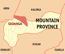 Map of Mountain Province showing the location of Sadanga | ||
.svg.png) Sadanga Location within the Philippines | ||
| Coordinates: 17°10′N 121°02′E / 17.167°N 121.033°ECoordinates: 17°10′N 121°02′E / 17.167°N 121.033°E | ||
| Country | Philippines | |
| Region | Cordillera Administrative Region (CAR) | |
| Province | Mountain Province | |
| District | Lone District | |
| Barangays | 8 | |
| Government[1] | ||
| • Mayor | Gabino P. Ganggangan | |
| Area[2] | ||
| • Total | 83.30 km2 (32.16 sq mi) | |
| Population (2010)[3] | ||
| • Total | 9,181 | |
| • Density | 110/km2 (290/sq mi) | |
| Time zone | PST (UTC+8) | |
| ZIP code | 2617 | |
| Dialing code | +63 (0)74 | |
| Income class | 5th class | |

Sadanga is a fifth class municipality in the province of Mountain Province, Philippines. According to the 2010 census, it has a population of 9,181 people.[3]
Barangays
Sadanga is politically subdivided into 8 barangays.[2]
- Anabel
- Belwang
- Betwagan
- Bekigan
- Poblacion
- Sacasacan
- Saclit
- Demang
Demographics
| Population census of Sadanga | ||
|---|---|---|
| Year | Pop. | ±% p.a. |
| 1990 | 7,302 | — |
| 1995 | 8,373 | +2.60% |
| 2000 | 8,596 | +0.57% |
| 2007 | 9,706 | +1.69% |
| 2010 | 9,181 | −2.00% |
| Source: National Statistics Office[3] | ||
References
- ↑ "Official City/Municipal 2013 Election Results". Intramuros, Manila, Philippines: Commission on Elections (COMELEC). 11 September 2013. Retrieved 23 December 2013.
- 1 2 "Province: Mountain Province". PSGC Interactive. Makati City, Philippines: National Statistical Coordination Board. Retrieved 23 December 2013.
- 1 2 3 "Total Population by Province, City, Municipality and Barangay: as of May 1, 2010" (PDF). 2010 Census of Population and Housing. National Statistics Office. Retrieved 23 December 2013.
External links
 |
Lubuagan, Kalinga | Tinglayan, Kalinga | | |
| Tubo, Abra | |
|||
| ||||
| | ||||
| Bontoc | Barlig |
Bontoc (capital) | |
| Municipalities | |
| Barangays | |
This article is issued from Wikipedia - version of the 12/1/2016. The text is available under the Creative Commons Attribution/Share Alike but additional terms may apply for the media files.