Sablan, Benguet
| Sablan | |||
|---|---|---|---|
| Municipality | |||
|
Sablan Municipal Hall | |||
| |||
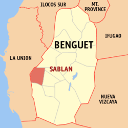 Location in the province of Benguet | |||
.svg.png) Sablan Location within the Philippines | |||
| Coordinates: 16°30′N 120°31′E / 16.5°N 120.52°ECoordinates: 16°30′N 120°31′E / 16.5°N 120.52°E | |||
| Country |
| ||
| Region | Cordillera Administrative Region (CAR) | ||
| Province | Benguet | ||
| District | Lone district of Benguet | ||
| Barangays | 8 | ||
| Government | |||
| • Mayor | Arthur Camacho Baldo | ||
| Area[1] | |||
| • Total | 105.63 km2 (40.78 sq mi) | ||
| Population (2015 census)[2] | |||
| • Total | 11,457 | ||
| • Density | 110/km2 (280/sq mi) | ||
| Time zone | PST (UTC+8) | ||
| ZIP code | 2614 | ||
| Dialing code | +63 (0)74 | ||
| Income class | 5th class | ||


Sablan is a fifth class municipality in the province of Benguet, Philippines. According to the 2015 census, it has a population of 11,457 people.[2]
History
The term "Sablan" was derived from the local word “Sabdang”, a local tree which thrived in the area.[3]
Sablan was created officially as a municipal district on July 1, 1927 under Executive Order No. 61 dated May 17, 1927 by then American Governor General Leonard Wood.[3]
Geography
Sablan is the westernmost municipality of Benguet. It is bounded by Kapangan on the north, Tublay on the northeast, La Trinidad on the east, Baguio City in the southeast, Tuba in the south, Aringay on the southwest, and Burgos to the west.
Barangays
Sablan is subdivided into 8 barangays:
| PSGC | Barangay | Population | ±% p.a. | ||
|---|---|---|---|---|---|
| 2015[2] | 2010[4] | ||||
| 141112002 | Bagong | 6.2% | 705 | 764 | −1.52% |
| 141112003 | Balluay | 4.7% | 536 | 507 | +1.06% |
| 141112004 | Banangan | 15.8% | 1,808 | 1,756 | +0.56% |
| 141112005 | Banengbeng | 9.4% | 1,072 | 1,108 | −0.63% |
| 141112006 | Bayabas | 21.5% | 2,467 | 2,068 | +3.42% |
| 141112007 | Kamog | 12.8% | 1,468 | 1,064 | +6.32% |
| 141112010 | Pappa | 5.2% | 593 | 594 | −0.03% |
| 141112011 | Poblacion | 24.5% | 2,808 | 2,650 | +1.11% |
| Total | 11,457 | 10,511 | +1.65% | ||
Demographics
| Population census of Sablan | ||
|---|---|---|
| Year | Pop. | ±% p.a. |
| 1990 | 8,440 | — |
| 1995 | 9,170 | +1.57% |
| 2000 | 9,652 | +1.10% |
| 2007 | 10,890 | +1.68% |
| 2010 | 10,511 | −1.28% |
| 2015 | 11,457 | +1.65% |
| Source: Philippine Statistics Authority[2][4][5] | ||
The population of Sablan, Benguet, in the 2015 census was 11,457 people,[2] with a density of 110 inhabitants per square kilometre or 280 inhabitants per square mile.
Education
Public schools
As of 2014, Sablan has 14 public elementary schools and 2 public secondary schools.[6][7][8]
|
|
Private schools
Saint Louis School of Sablan is the only private secondary school in the municipality, located at barangay Poblacion.
Major roads
- Quirino Highway (formerly Naguilian Road)
- Asin Road
References
- ↑ "Province: Benguet". PSGC Interactive. Makati City, Philippines: National Statistical Coordination Board. Retrieved 12 August 2013.
- 1 2 3 4 5 "CORDILLERA ADMINISTRATIVE REGION (CAR)". Census of Population (2015): Total Population by Province, City, Municipality and Barangay (Report). PSA. Retrieved 20 June 2016.
- 1 2 "Municipality of Sablan, Benguet profile". DILG - CAR. Department of Interior and Local Government (Philippines). Retrieved 16 September 2014.
- 1 2 "CORDILLERA ADMINISTRATIVE REGION (CAR)". Census of Population and Housing (2010): Total Population by Province, City, Municipality and Barangay (Report). NSO. Retrieved 29 June 2016.
- ↑ "Province of Benguet". Municipality Population Data. LWUA Research Division. Retrieved 12 August 2013.
- ↑ "Masterlist of Public Elementary Schools for the School year 2012- 2013" (XLSX). Department of Education (Philippines), July 15, 2013. Retrieved 28 December 2014.
- 1 2 "Masterlist of Secondary Schools (School Year 2013- 2014)" (XLSX). Department of Education (Philippines), July 4, 2013. Retrieved 20 November 2014.
- 1 2 "Masterlist of Public Schools SY 2013-2014" (XLSX). Department of Education (Philippines), 22 October 2014. Retrieved 28 December 2014.
External links
| Wikimedia Commons has media related to Sablan, Benguet. |
 |
Kapangan | | ||
| Burgos, La Union Naguilian, La Union |
|
Tublay La Trinidad | ||
| ||||
| | ||||
| Aringay, La Union | Tuba | Baguio |
La Trinidad (capital) | |
| Municipalities | |
| Highly urbanized city |
|
| Barangays | |