Bangued, Abra
| Bangued | ||
|---|---|---|
| Municipality | ||
|
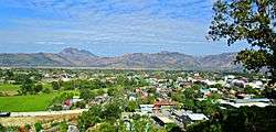
View of Abra Valley from Casamata Hill | ||
| ||
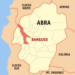 Location within Abra province | ||
.svg.png) Bangued Location within the Philippines | ||
| Coordinates: 17°36′N 120°37′E / 17.6°N 120.62°ECoordinates: 17°36′N 120°37′E / 17.6°N 120.62°E | ||
| Country | Philippines | |
| Region | Cordillera Administrative Region (CAR) | |
| Province | Abra | |
| District | Lone District of Abra | |
| Barangays | 31 (see Barangays) | |
| Government [1] | ||
| • Type | Sangguniang Bayan | |
| • Mayor | Dominic "Nic" Busuego Valera | |
| Area[2] | ||
| • Total | 105.7 km2 (40.8 sq mi) | |
| Population (2015 census)[3] | ||
| • Total | 48,163 | |
| • Density | 460/km2 (1,200/sq mi) | |
| • Voter (2016)[4] | 27,162 | |
| Time zone | PST (UTC+8) | |
| ZIP code | 2800 | |
| IDD : area code | +63 (0)74 | |
| Income class | 1st class | |
| PSGC | 140101000 | |
| Website |
www | |

Bangued, officially the Municipality of Bangued (Ilocano: Ili ti Bangued, Filipino: Bayan ng Bangued), is the capital municipality of the province of Abra in the Cordillera Administrative Region (CAR) of the Philippines. The population was 48,163 at the 2015 census.[3][3] In the 2016 election, it had 27,162 registered voters.[4]
History
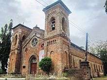
The name "Bangued" means "roadblock". It was established as a regular town in 1598 and was made the seat of the provincial government of Abra on July 25, 1861. The inauguration coincided with the feast day of Saint James the Great.
The early settlers were the Tingguians belonging to the Bago, Itneg, Masadiit, lbanao, and Indayas tribes, who latter intermarried with the immigrants from Ilocos Sur. The Tingguians opposed the Christianization introduced by the Spanish friars who penetrated the eastern settlements. The Tingguian residents prevented the Spaniards from penetrating their area of which they placed roadblocks on all roads leading to the place. They also cut large logs and threw them to the Abra River to prevent the incoming colonizers from entering the area with the use of their boats and bamboo rafts. These logs were made as obstacles and big rocks were placed along the roads which the natives called "banggen", meaning obstacles.
When the conquistadores, led by Juan de Salcedo, decided to penetrate the area, they proceeded eastward and saw for themselves the logs along the Abra River, and the stones placed there to block all roads leading to the community. Salcedo's subaltern happened to meet one of the natives and asked what was the name of the place. Thinking that the Spaniards were inquiring about the roadblocks, he answered "banggen" and the subaltern jotted down on his notebook about the word.
The Spaniards were successful in their attempt to penetrate the inner communities in the east by removing the obstacles, saying in Spanish "Abra esos obstáculos" and it was in that happening when they developed the area and established the towns and barangays. The place where they found many obstacles, they named it "Bangen" and the province they called it "Abra".
When the Americans colonized the country and established the civil government, the town's name was modified to "Bangued".
In 1692, Augustinians under Fray Columbo made Bangued an independent mission territory. Earlier in 1615, Juan Pareja organized Bangued as a mission center and baptized 3,000 Tingguians with the help of their chief, Manuel Dumawal.
Modern-day Bangued was formally organized in 1704 until it was decided to become the capital town of Abra in 1863. It has 31 barangays, seven of them in the town proper.
Conversion to cityhood
Cityhood for Bangued is being given a push in the 16th Congress. Abra Representative Ma. Jocelyn Bernos filed a resolution seeking congressional nod for the capital town’s cityhood.[5]
Geography
Bangued is a landlocked municipality, located at 17°36′N 120°37′E / 17.6°N 120.62°E. It is elongated in shape towards the north and south, and bisected through the center by the large Abra River. It is situated in the western portion of the province with boundaries defined by the Province of Ilocos Norte and the Municipality of Danglas in the north; La Paz, Tayum and Peñarrubia in the east; San Isidro in the south, and Langiden and Pidigan in the west.
According to the Philippine Statistics Authority, the municipality has a land area of 105.7 square kilometres (40.8 sq mi)[2] constituting 2.54% of the 4,165.25-square-kilometre- (1,608.21 sq mi) total area of Abra. The town is generally mountainous from north to south; however, it is flat and rolling at the midsection. From here it has an elevation of 30 metres (98 ft) above mean sea level. In the north, which consists mostly of mountains, elevation ranges from 60 to 1,036 metres (197 to 3,399 ft). In the south, which is interspersed with mountain and hills, elevation ranges from 45 to 300 metres (148 to 984 ft). One such hill is Cassamata Hill which was declared a national park.
Bangued is accessible through the Abra-Ilocos Sur National Road from the west, Abra-Kalinga Road from the north-east, and Abra-Ilocos Norte Road from the North. It is 408 kilometres (254 mi) from Manila, 197 kilometres (122 mi) from Baguio and 60 kilometres (37 mi) from Vigan.
Climate
The climate falls under the first type of tropical climate, which is characterized by two pronounced seasons, dry from November to April and wet during the remaining months of the year. Prevailing wind blowing in the area is mostly in the direction from north-west to southeast. However, during summer in the absence of weather disturbance, wind blows from north to south or east to west.
Barangays
Bangued is politically subdivided into 31 barangays[6] with 77 sitios.
| PSGC | Barangay | Population | ±% p.a. | ||
|---|---|---|---|---|---|
| 2015[3] | 2010[7] | ||||
| 140101001 | Agtangao | 4.8% | 2,295 | 2,164 | +1.13% |
| 140101002 | Angad | 5.1% | 2,464 | 2,298 | +1.34% |
| 140101004 | Bañacao | 5.2% | 2,486 | 1,749 | +6.92% |
| 140101003 | Bangbangar | 2.6% | 1,243 | 1,190 | +0.83% |
| 140101005 | Cabuloan | 2.1% | 1,028 | 1,131 | −1.80% |
| 140101006 | Calaba | 7.3% | 3,494 | 2,890 | +3.68% |
| 140101009 | Cosili East (Proper) | 1.9% | 908 | 957 | −1.00% |
| 140101008 | Cosili West (Buaya) | 2.8% | 1,336 | 1,175 | +2.48% |
| 140101010 | Dangdangla | 4.5% | 2,149 | 1,623 | +5.49% |
| 140101011 | Lingtan | 1.8% | 859 | 862 | −0.07% |
| 140101012 | Lipcan | 4.1% | 1,975 | 1,676 | +3.17% |
| 140101013 | Lubong | 1.5% | 699 | 690 | +0.25% |
| 140101014 | Macarcarmay | 1.4% | 667 | 695 | −0.78% |
| 140101016 | Macray | 1.6% | 749 | 755 | −0.15% |
| 140101017 | Malita | 0.8% | 401 | 373 | +1.39% |
| 140101015 | Maoay | 1.5% | 742 | 736 | +0.15% |
| 140101018 | Palao | 3.5% | 1,697 | 1,676 | +0.24% |
| 140101019 | Patucannay | 3.0% | 1,450 | 1,411 | +0.52% |
| 140101020 | Sagap | 1.8% | 863 | 775 | +2.07% |
| 140101021 | San Antonio | 1.8% | 878 | 913 | −0.74% |
| 140101022 | Santa Rosa | 4.1% | 1,997 | 1,784 | +2.17% |
| 140101023 | Sao-atan | 2.2% | 1,077 | 976 | +1.89% |
| 140101024 | Sappaac | 2.7% | 1,318 | 1,238 | +1.20% |
| 140101007 | Tablac (Calot) | 3.2% | 1,541 | 1,408 | +1.73% |
| 140101031 | Zone 1 Poblacion (Nalasin) | 4.6% | 2,212 | 2,017 | +1.77% |
| 140101025 | Zone 2 Poblacion (Consiliman) | 2.9% | 1,376 | 1,325 | +0.72% |
| 140101026 | Zone 3 Poblacion (Lalaud) | 4.0% | 1,927 | 1,622 | +3.34% |
| 140101027 | Zone 4 Poblacion (Town Proper) | 2.2% | 1,073 | 1,040 | +0.60% |
| 140101028 | Zone 5 Poblacion (Bo. Barikir) | 5.3% | 2,566 | 2,277 | +2.30% |
| 140101029 | Zone 6 Poblacion (Sinapangan) | 3.9% | 1,884 | 1,789 | +0.99% |
| 140101030 | Zone 7 Poblacion (Baliling) | 5.8% | 2,809 | 2,721 | +0.61% |
| Total | 48,163 | 43,936 | +1.76% | ||
Demographics
| Population census of Bangued | |||||||||||||||||||||||||
|---|---|---|---|---|---|---|---|---|---|---|---|---|---|---|---|---|---|---|---|---|---|---|---|---|---|
|
| ||||||||||||||||||||||||
| Source: Philippine Statistics Authority[3][7][8] | |||||||||||||||||||||||||
In the 2015 census, Bangued had a population of 48,163.[3] The population density was 460 inhabitants per square kilometre (1,200/sq mi).
In the 2016 election, it had 27,162 registered voters.[4]
Economy
The economy of the municipality is heavily dependent on agriculture particularly palay and corn, followed by trade and industry. Chinese businessmen dominate trade and manufacturing as a common preoccupation of the populace.
The commercial activity of Bangued is confined in the urban core establishing a linear pattern of development along major thoroughfares. This is evident from Torrijos Street to Taft Street of Zone 5, McKinley Street to Santiago Street and Partelo Street of Zone 4, and Capitulacion Street of Zone 1 and Zone 2.
For the year 2000 there were 1,539 commercial/business enterprises classified as wholesale and retail trade, dry and wet markets, banking and finance, service and others. There were 9 large suppliers of lumber, hardware and other construction supplies and materials. Likewise there were also about 3 large contractors with undetermined number of small to medium scale. On the other hand, there were also a number of large to medium scale suppliers of general merchandise, groceries and various types of prime commodities.
As the economic center of Abra, small scale or cottage industries abound. The most common are hollow blocks and other concrete products manufacturing with gravel and sand readily available at the Abra River bank. Wood and bamboo craft are also promising business enterprises with raw materials available in the vicinity and in the hinterlands for narra and other species of hardwood, rattan, and bamboos. Metalcraft, tinsmithing, jewelry making is also expanding while a lot of households are now in the small scale processing or value adding activities appertaining to various food items.
Hospitals & clinics
- Bangued Christian Hospital, Lorben's Hill, Torrijos St., Zone 5 — Private
- Abra Provincial Hospital, Barangay Calaba — Public
- Seares Memorial Clinic, Zone 4 — Private
- Saint James Clinic, Zone 7 — Private
- Saint Jude Clinic, Zone 7 — Private
- Bobila Clinic, Zone 7 — Private
Education
The municipality has a total of 24 Educational Institutions at all levels. 21 belong to the government while the rest are private. Of the total public schools, 19 belongs to the elementary levels. Most of the educational institutions of higher levels secondary and tertiary are concentrated in the urban core, while elementary schools are strategically located in different barangays forming their own catchment areas.
Aside from these institutions there are at least 15 daycare centers located in different barangays, and 5 private institutions for pre-schoolers complementing that from the government.
The total number of elementary school teachers in the public sector is 218 giving a gross teacher pupil ratio of 1:30 (SY 1999-2000 DepEd), in the private there are 193 with a ratio of 1:28 in the same period. Two public libraries complement existing facilities, the Provincial Library located al Santiago St. Zone 3 and the Integrated Bar of the Philippines Library located at the Municipal Trial Court.
Colleges
- Divine Word College of Bangued, Zone 6 — Private
- Abra Valley Colleges, Zone 4 — Semi-private
- Data Center College of the Phils., Zone 5 — Private
- Abra State Institute of Sciences and Technology, Zone 3 — Public
High schools
- Divine Word College of Bangued, Zone 6 — Private
- Abra Valley Colleges, Zone 4 — Private
- Holy Spirit Academy of Bangued, Zone 5 — Private;
- Abra State Institute of Sciences and Technology, Zone 3 — Public
- Abra High School, Zone 3 — Public
- Saint Joseph Seminary
- Sacred Heart School of Bangued, Zone 6 — Private
Transportation
Passenger buses, mini-buses, jeepneys and tricycles including cargo are the major means of transportation in the town. Buses, mini-buses and jeepneys ply the longer routes covering the entire province of Abra and out, while tricycles serve only the inner arteries of the municipality's barangays including the adjacent towns of Pidigan, Tayum and Peñarrubia on a chartered ride basis.
Buses going to Manila have their own permanent station/terminal, while all the rest are accommodated and parked along various open lots, gasoline stations, etc.
There are jeeps that ply from Bangued to Narvacan.
Sister cities
References
- ↑ "Municipality". Quezon City, Philippines: Department of the Interior and Local Government. Retrieved 31 May 2013.
- 1 2 "Province: Abra". PSGC Interactive. Makati City, Philippines: Philippine Statistics Authority. Retrieved 28 October 2016.
- 1 2 3 4 5 6 "CORDILLERA ADMINISTRATIVE REGION (CAR)". Census of Population (2015): Total Population by Province, City, Municipality and Barangay (Report). PSA. Retrieved 20 June 2016.
- 1 2 3 "2016 National and Local Elections Statistics". Commission on Elections. 2016.
- ↑ Dumlao, Artemio (13 July 2013). "Bangued cityhood pushed in Congress". The Philippine Star. Archived from the original on 14 July 2013. Retrieved 10 October 2016.
- ↑ "Municipal: Bangued, Abra". PSA. Philippines: National Statistical Coordination Board. Retrieved 8 January 2016.
- 1 2 "CORDILLERA ADMINISTRATIVE REGION (CAR)". Census of Population and Housing (2010): Total Population by Province, City, Municipality and Barangay (Report). NSO. Retrieved 29 June 2016.
- ↑ "CORDILLERA ADMINISTRATIVE REGION (CAR)". Census of Population (1995, 2000 and 2007): Total Population by Province, City and Municipality (Report). NSO. Archived from the original on 24 June 2011.
- ↑ "Vigan City and Bangued, Abra forge Sisterhood ties". Vigan City Council. 26 November 2008. Archived from the original on 29 January 2009. Retrieved 11 October 2016.
External links
| Wikimedia Commons has media related to Bangued, Abra. |
 |
San Juan, Ilocos Sur | Nueva Era, Ilocos Norte | Danglas | |
| Langiden Pidigan |
|
La Paz Tayum Bucay Peñarrubia | ||
| ||||
| | ||||
| San Isidro | Bucay |
Bangued (capital) | |
| Municipalities | |
| Barangays | |