Tubo, Abra
| Tubo | ||
|---|---|---|
| Municipality | ||
| ||
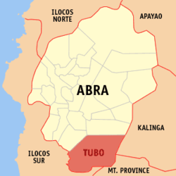 Location within Abra province | ||
.svg.png) Tubo Location within the Philippines | ||
| Coordinates: 17°16′N 120°44′E / 17.26°N 120.73°ECoordinates: 17°16′N 120°44′E / 17.26°N 120.73°E | ||
| Country | Philippines | |
| Region | Cordillera Administrative Region (CAR) | |
| Province | Abra | |
| District | Lone District of Abra | |
| Barangays | 10 (see Barangays) | |
| Government [1] | ||
| • Type | Sangguniang Bayan | |
| • Mayor | Guilbert P. Ballangan | |
| Area[2] | ||
| • Total | 409.87 km2 (158.25 sq mi) | |
| Population (2015 census)[3] | ||
| • Total | 5,699 | |
| • Density | 14/km2 (36/sq mi) | |
| • Voter (2016)[4] | 3,378 | |
| Time zone | PST (UTC+8) | |
| ZIP code | 2814 | |
| IDD : area code | +63 (0)74 | |
| Income class | 4th class | |
| PSGC | 140126000 | |

Tubo, officially the Municipality of Tubo (Ilocano: Ili ti Tubo, Filipino: Bayan ng Tubo), is a municipality in the province of Abra in the Cordillera Administrative Region (CAR) of the Philippines. The population was 5,699 at the 2015 census.[3] In the 2016 election, it had 3,378 registered voters.[4]
The municipality was created on June 17, 1967 from the former municipal district of the same name, through Republic Act 5161.[5]
History
The inhabitants belong to the Maeng tribe and speak the dialect of the same name. There is however one barangay, Tabacda, that speaks a different dialect. This is because they are believed to have originated from Kalinga. Everyone can understand and speak the common dialect though.
Agriculture is the main source of livelihood but various industries are starting to grow. Slash-and-burn farming is now less done while tree planting for commercial purposes is gaining ground.
While almost all barangays are now interconnected with a one way road network and have electricity; the others still can only be reached by foot and are using either an electric generator and or gas to light up the night.
Geography
Tubo is located at 17°16′N 120°44′E / 17.26°N 120.73°E.
According to the Philippine Statistics Authority, the municipality has a land area of 409.87 square kilometres (158.25 sq mi)[2] constituting 9.84% of the 4,165.25-square-kilometre- (1,608.21 sq mi) total area of Abra.
It is situated approximately 55 kilometres (34 mi) from the provincial capital Bangued, and is at the southern tip of Abra. The town is bounded on the west by Ilocos Sur and Luba, Abra, north by Boliney, east by Kalinga and Mountain Province, and south by Mountain Province and Ilocos Sur.
Tubo can be reached through various routes. Coming from Bangued, the place can be reached by passing through the towns of Peñarrubia-Bucay-Manabo and Luba. It could also be reached via Candon-San Emilio and Tagudin-Quirino of the nearby province of Ilocos Sur, or via Besao of Mountain Province or Kalinga. Unfortunately, no road links exist herein.
Barangays
Tubo is politically subdivided into 10 barangays.[6]
| PSGC | Barangay | Population | ±% p.a. | ||
|---|---|---|---|---|---|
| 2015[3] | 2010[7] | ||||
| 140126001 | Alangtin | 9.7% | 552 | 650 | −3.06% |
| 140126002 | Amtuagan | 8.6% | 492 | 494 | −0.08% |
| 140126003 | Dilong | 14.3% | 814 | 818 | −0.09% |
| 140126004 | Kili | 7.3% | 414 | 426 | −0.54% |
| 140126005 | Poblacion (Mayabo) | 10.2% | 581 | 582 | −0.03% |
| 140126006 | Supo | 13.4% | 762 | 732 | +0.77% |
| 140126010 | Tabacda | 5.1% | 289 | 246 | +3.11% |
| 140126007 | Tiempo | 14.8% | 843 | 800 | +1.00% |
| 140126008 | Tubtuba | 7.8% | 442 | 491 | −1.98% |
| 140126009 | Wayangan | 8.9% | 510 | 480 | +1.16% |
| Total | 5,699 | 5,719 | −0.07% | ||
The 10 barangays are grouped into three (3) zones:
- Zone 1: Poblacion (Mayabo), Wayangan and Supo
- Zone 2: Tiempo, Kili, Tabacda and Amtuagan
- Zone 3: Alangtin-Batayan, Tubtuba and Dilong
Demographics
| Population census of Tubo | |||||||||||||||||||||||||
|---|---|---|---|---|---|---|---|---|---|---|---|---|---|---|---|---|---|---|---|---|---|---|---|---|---|
|
| ||||||||||||||||||||||||
| Source: PSA[3][7][8] | |||||||||||||||||||||||||
In the 2015 census, Tubo had a population of 5,699.[3] The population density was 14 inhabitants per square kilometre (36/sq mi).
In the 2016 election, it had 3,378 registered voters.[4]
References
- ↑ "Municipality". Quezon City, Philippines: Department of the Interior and Local Government. Retrieved 31 May 2013.
- 1 2 "Province: Abra". PSGC Interactive. Makati City, Philippines: Philippine Statistics Authority. Retrieved 28 October 2016.
- 1 2 3 4 5 "CORDILLERA ADMINISTRATIVE REGION (CAR)". Census of Population (2015): Total Population by Province, City, Municipality and Barangay (Report). PSA. Retrieved 20 June 2016.
- 1 2 3 "2016 National and Local Elections Statistics". Commission on Elections. 2016.
- ↑ "Republic Act No. 5161 - An Act Creating the Municipality of Tubo in the Province of Abra". Chan Robles Virtual Law Library. 17 June 1967. Retrieved 17 February 2016.
- ↑ "Municipal: Tubo, Abra". PSA. Philippines: National Statistical Coordination Board. Retrieved 8 January 2016.
- 1 2 "CORDILLERA ADMINISTRATIVE REGION (CAR)". Census of Population and Housing (2010): Total Population by Province, City, Municipality and Barangay (Report). NSO. Retrieved 29 June 2016.
- ↑ "CORDILLERA ADMINISTRATIVE REGION (CAR)". Census of Population (1995, 2000 and 2007): Total Population by Province, City and Municipality (Report). NSO. Archived from the original on 24 June 2011.
External links
| Wikimedia Commons has media related to Tubo, Abra. |
 |
Luba | Boliney | Pasil, Kalinga | |
| San Emilio, Ilocos Sur | |
Lubuagan, Kalinga Sadanga, Mountain Province | ||
| ||||
| | ||||
| Quirino, Ilocos Sur / Besao, Mt. Prov. / Sagada, Mt. Prov. | Bontoc, Mountain Province |
Bangued (capital) | |
| Municipalities | |
| Barangays | |