Wise County, Texas
| Wise County, Texas | |
|---|---|
|
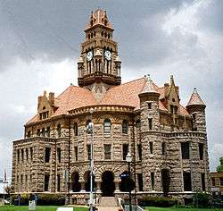
The Wise County Courthouse in Decatur. The Romanesque Revival structure was added to the National Register of Historic Places in 1976. | |
 Location in the U.S. state of Texas | |
 Texas's location in the U.S. | |
| Founded | 1856 |
| Named for | Henry Alexander Wise |
| Seat | Decatur |
| Largest city | Decatur |
| Area | |
| • Total | 923 sq mi (2,391 km2) |
| • Land | 904 sq mi (2,341 km2) |
| • Water | 18 sq mi (47 km2), 2.0% |
| Population | |
| • (2010) | 59,127 |
| • Density | 65/sq mi (25/km²) |
| Congressional districts | 12th, 13th |
| Time zone | Central: UTC-6/-5 |
| Website |
www |
Wise County is a county located in the U.S. state of Texas. As of the 2010 census, the population was 59,127.[1] Its county seat is Decatur.[2]
Wise County is part of the Dallas-Fort Worth-Arlington, TX Metropolitan Statistical Area.
The Wise Eyes crime watch program, eventually adopted by mostly rural counties in several states, was started in 1993 by then-Sheriff Phil Ryan.[3]
History
On November 10, 1837 the Battle of the Knobs was fought in what is now Wise County between about 150 Indian warriors and just 18 Republic of Texas soldiers under Lieutenant A. B. Benthuysen. Despite being heavily outnumbered, the Texas soldiers held their ground, with an estimated 50 Indians killed or wounded and 10 of the Texans dead. Settlers began coming into the area not long afterwards. Wise County itself was founded in 1856. It was named after Virginia Congressman Henry A. Wise, who had supported Texas annexation by the United States.[4]
Hydraulic fracturing
In recent years, Wise County allowed an increase in hydraulic fracturing. In 2011, the Parr family and others filed a lawsuit against several energy companies, including Republic Energy, Inc. and Ryder Scott Petroleum, claiming the extracting processes have created health complications for their family and neighbors.[5] In April 2014, the Parrs won a $2.9 million award from a Dallas jury.[6]
Geography
According to the U.S. Census Bureau, the county has a total area of 923 square miles (2,390 km2), of which 904 square miles (2,340 km2) is land and 18 square miles (47 km2) (2.0%) is water.[7]
Adjacent counties
- Montague County (north)
- Cooke County (northeast)
- Denton County (east)
- Tarrant County (southeast)
- Parker County (south)
- Jack County (west)
National protected area
Demographics
| Historical population | |||
|---|---|---|---|
| Census | Pop. | %± | |
| 1860 | 3,160 | — | |
| 1870 | 1,450 | −54.1% | |
| 1880 | 16,601 | 1,044.9% | |
| 1890 | 24,134 | 45.4% | |
| 1900 | 27,116 | 12.4% | |
| 1910 | 26,450 | −2.5% | |
| 1920 | 23,363 | −11.7% | |
| 1930 | 19,178 | −17.9% | |
| 1940 | 19,074 | −0.5% | |
| 1950 | 16,141 | −15.4% | |
| 1960 | 17,012 | 5.4% | |
| 1970 | 19,687 | 15.7% | |
| 1980 | 26,575 | 35.0% | |
| 1990 | 34,679 | 30.5% | |
| 2000 | 48,793 | 40.7% | |
| 2010 | 59,127 | 21.2% | |
| Est. 2015 | 62,953 | [8] | 6.5% |
| U.S. Decennial Census[9] 1850–2010[10] 2010–2014[1] | |||
As of the census[11] of 2000, there were 48,793 people, 17,178 households, and 13,467 families residing in the county. The population density was 54 people per square mile (21/km²). There were 19,242 housing units at an average density of 21 per square mile (8/km²). The racial makeup of the county was 91.01% White, 1.23% Black, 0.75% Native American, 0.22% Asian, 0.04% Pacific Islander, 5.03% from other races, and 1.71% from two or more races. 10.76% of the population were Hispanic or Latino of any race.
There were 17,178 households out of which 38.20% had children under the age of 18 living with them, 66.10% were married couples living together, 8.20% had a female householder with no husband present, and 21.60% were non-families. 18.30% of all households were made up of individuals and 7.10% had someone living alone who was 65 years of age or older. The average household size was 2.77 and the average family size was 3.14.
A Williams Institute analysis of 2010 census data found there were about 3.4 same-sex couples per 1,000 households in the county.[12]
In the county, the population was spread out with 28.30% under the age of 18, 7.80% from 18 to 24, 30.20% from 25 to 44, 23.00% from 45 to 64, and 10.60% who were 65 years of age or older. The median age was 36 years. For every 100 females there were 101.50 males. For every 100 females age 18 and over, there were 99.40 males.
The median income for a household in the county was $41,933, and the median income for a family was $47,909. Males had a median income of $35,913 versus $23,434 for females. The per capita income for the county was $17,729. About 7.50% of families and 9.90% of the population were below the poverty line, including 11.30% of those under age 18 and 10.60% of those age 65 or over.
Politics
Wise County, like most rural counties in Texas, votes reliably for Republican candidates in statewide and national elections.
| Party | Candidate | Votes | % | |
|---|---|---|---|---|
| Republican | Mitt Romney | 17,207 | 83.0 | |
| Democratic | Barack Obama | 3,221 | 15.5 | |
| Party | Candidate | Votes | % | |
|---|---|---|---|---|
| Republican | Greg Abbott | 10,169 | 80.5 | |
| Democratic | Wendy Davis | 2,178 | 17.3 | |
Education
The following school districts lie entirely within Wise County:
- Alvord Independent School District
- Boyd Independent School District
- Bridgeport Independent School District
- Chico Independent School District
- Decatur Independent School District
- Paradise Independent School District
- Northwest Independent School District
- Slidell Independent School District
The following private educational institutions serve Wise County:
- Victory Christian Academy
The following higher education institutions serve Wise County:
Transportation
Major highways
 U.S. Highway 81
 U.S. Highway 287
 U.S. Highway 380
 State Highway 101
 State Highway 114
 State Highway 199
Airports
The following public-use airports are located in the county:[13]
- Bishop Airport (76T)
- Bridgeport Municipal Airport (XBP)
- Decatur Municipal Airport (LUD)
- Heritage Creek Airstrip (58T)
- Rhome Meadows Airport (T76)
Communities
- Alvord
- Aurora
- Balsora
- Boonsville
- Boyd
- Briar (partly in Tarrant and Parker Counties)
- Bridgeport
- Chico
- Cottondale
- Decatur (county seat)
- Fort Worth (mostly in Tarrant County with small parts in Denton, Parker and Wise Counties)
- Greenwood
- Lake Bridgeport
- New Fairview
- Newark (small part in Tarrant County)
- Paradise
- Pecan Acres (mostly in Tarrant County)
- Rhome
- Runaway Bay
- Slidell
See also
References
- 1 2 "State & County QuickFacts". United States Census Bureau. Retrieved December 29, 2013.
- ↑ "Find a County". National Association of Counties. Retrieved 2011-06-07.
- ↑ WCMessenger.com: Wise Eyes expands its vision
- ↑ http://www.co.wise.tx.us/ Wise County
- ↑ http://dfw.cbslocal.com/2011/03/08/wise-county-family-sues-over-natural-gas-fracking/ CBS.com
- ↑ "Wise County pair wins $3 million jury award in drilling lawsuit". Star-Telegram (Fort Worth TX). Retrieved 11 April 2015.
- ↑ "2010 Census Gazetteer Files". United States Census Bureau. August 22, 2012. Retrieved May 12, 2015.
- ↑ "County Totals Dataset: Population, Population Change and Estimated Components of Population Change: April 1, 2010 to July 1, 2015". Retrieved July 2, 2016.
- ↑ "U.S. Decennial Census". United States Census Bureau. Retrieved May 12, 2015.
- ↑ "Texas Almanac: Population History of Counties from 1850–2010" (PDF). Texas Almanac. Retrieved May 12, 2015.
- ↑ "American FactFinder". United States Census Bureau. Retrieved 2011-05-14.
- ↑ Where Same-Sex Couples Live, June 26, 2015, retrieved July 6, 2015
- ↑ Public and Private Airports, Wise County, Texas
External links
| Wikisource has the text of the 1879 American Cyclopædia article Wise. |
- Wise County Genealogy Resources
- Wise County on the Web
- Wise County government's website
- "The Blog" - A Local Blog About Wise County
- Wise County in Handbook of Texas Online at the University of Texas
 |
Clay County | Montague County | Cooke County | |
| Jack County | |
Denton County | ||
| ||||
| | ||||
| Palo Pinto County | Parker County | Tarrant County |
Municipalities and communities of Wise County, Texas, United States | ||
|---|---|---|
| Cities | | |
| Towns | ||
| CDPs | ||
| Unincorporated communities | ||
| Ghost town |
| |
| Footnotes | ‡This populated place also has portions in an adjacent county or counties | |

Coordinates: 33°13′N 97°39′W / 33.22°N 97.65°W