Kleberg County, Texas
Not to be confused with Kleberg, Texas.
| Kleberg County, Texas | |
|---|---|
|
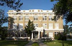
The Kleberg County Courthouse in Kingsville. The building was added to the National Register of Historic Places on May 10, 2010. | |
 Location in the U.S. state of Texas | |
 Texas's location in the U.S. | |
| Founded | 1913 |
| Named for | Robert J. Kleberg |
| Seat | Kingsville |
| Largest city | Kingsville |
| Area | |
| • Total | 1,090 sq mi (2,823 km2) |
| • Land | 881 sq mi (2,282 km2) |
| • Water | 209 sq mi (541 km2), 19% |
| Population | |
| • (2010) | 32,061 |
| • Density | 36/sq mi (14/km²) |
| Congressional district | 34th |
| Time zone | Central: UTC-6/-5 |
| Website |
www |
Kleberg County (/ˈkleɪbərɡ/ KLAY-burg) is a county in the U.S. state of Texas. As of the 2010 census, its population was 32,061.[1] The county seat is Kingsville.[2] The county was organized in 1913[3] and is named for Robert J. Kleberg, an early settler.
Kleberg County is part of the Kingsville, TX Micropolitan Statistical Area, which is also part of the Corpus Christi-Kingsville-Alice, TX Combined Statistical Area. Most of the county's land lies in the famed King Ranch, which also extends into neighboring counties.
Kleberg County is represented in the Texas House of Representatives by the Republican J. M. Lozano, a restaurateur in Kingsville and in Alice, Texas.
Geography
According to the U.S. Census Bureau, the county has a total area of 1,090 square miles (2,800 km2), of which 881 square miles (2,280 km2) is land and 209 square miles (540 km2) (19%) is water.[4] It borders the Gulf of Mexico. Baffin Bay makes up a large part of the border with Kenedy County.
Major highways
 U.S. Highway 77
 The future route of Interstate 69E is planned to follow the current route of U.S. 77 in most places.
 State Highway 141
 State Highway 285
 Farm to Market Road 771
 Park Road 22
Adjacent counties
- Nueces County (north)
- Kenedy County (south)
- Brooks County (southwest)
- Jim Wells County (west)
National protected area
Demographics
| Historical population | |||
|---|---|---|---|
| Census | Pop. | %± | |
| 1920 | 7,837 | — | |
| 1930 | 12,451 | 58.9% | |
| 1940 | 13,344 | 7.2% | |
| 1950 | 21,991 | 64.8% | |
| 1960 | 30,052 | 36.7% | |
| 1970 | 33,166 | 10.4% | |
| 1980 | 33,358 | 0.6% | |
| 1990 | 30,274 | −9.2% | |
| 2000 | 31,549 | 4.2% | |
| 2010 | 32,061 | 1.6% | |
| Est. 2015 | 31,857 | [5] | −0.6% |
| U.S. Decennial Census[6] 1850–2010[7] 2010–2014[1] | |||
As of the census[8] of 2000, there were 31,549 people, 10,896 households, and 7,681 families residing in the county. The population density was 36 people per square mile (14/km²). There were 12,743 housing units at an average density of 15 per square mile (6/km²). The racial makeup of the county was 71.87% White, 3.70% Black or African American, 0.61% Native American, 1.47% Asian, 0.10% Pacific Islander, 19.00% from other races, and 3.25% from two or more races. 65.41% of the population were Hispanic or Latino of any race.
There were 10,896 households out of which 34.90% had children under the age of 18 living with them, 52.10% were married couples living together, 13.90% had a female householder with no husband present, and 29.50% were non-families. 22.30% of all households were made up of individuals and 7.60% had someone living alone who was 65 years of age or older. The average household size was 2.78 and the average family size was 3.30.
In the county, the population was spread out with 27.30% under the age of 18, 15.70% from 18 to 24, 27.40% from 25 to 44, 19.00% from 45 to 64, and 10.60% who were 65 years of age or older. The median age was 29 years. For every 100 females there were 101.00 males. For every 100 females age 18 and over, there were 98.50 males.
The median income for a household in the county was $29,313, and the median income for a family was $33,055. Males had a median income of $31,179 versus $19,494 for females. The per capita income for the county was $13,542. About 21.20% of families and 26.70% of the population were below the poverty line, including 35.50% of those under age 18 and 15.60% of those age 65 or over.
Robert Justus Kleberg
Kleberg county is named after Robert Justus Kleberg Sr. (1803–1888), a Prussian settler, was born on September 10, 1803, in Herstelle, Westphalia. His father was a merchant. Kleberg was educated in the classics and attended the University of Göttingen, where he received a J.D. degree. After graduating he was appointed a justice of assizes. He married Rosalie von Roeder near Paderborn, Prussia, in ...1834. They emigrated to Texas that year and settled in Cat Spring in 1836. In the Republic of Texas, Kleberg was associate commissioner and president of the Board of Land Commissioners (1837–38), justice of the peace (1841), and chief justice of Austin County (1846). In 1847 the Kleberg’s moved to Meyersville, where Kleberg was elected county commissioner in 1848 and chief justice in 1853. Kleberg fought in the battle of San Jacinto in Capt. Moseley Baker's company and subsequently served as one of the Texas guards for Gen. Santa Anna. After the revolution, he volunteered for six months' duty in the Texas army in a campaign against the Indians on Escondido Creek. Kleberg supported the cause of the Confederacy. When the Civil War broke out he raised a company of militia but because of his advanced age was not received into active service. Robert and Rosa raised their own seven children in addition to several young Roeder relatives. Their youngest son, Robert Justus Kleberg Jr. married Alice Gertrudis King. Kleberg died on October 23, 1888, near Cuero and was buried there. His grave is marked by a monument in the form of a soldier's tent with the words "Remember the Alamo" carved at the base. Kleberg County was named in his honor in 1913; a marker at his home site near Cuero was erected in 1936.
Communities
Cities and towns
- Kingsville (county seat)
- Corpus Christi (partly in Nueces County)
Census-designated places
Unincorporated communities
- Loyola Beach
- Vattmann
See also
- List of museums in the Texas Gulf Coast
- National Register of Historic Places listings in Kleberg County, Texas
References
- 1 2 "State & County QuickFacts". United States Census Bureau. Retrieved December 18, 2013.
- ↑ "Find a County". National Association of Counties. Retrieved 2011-06-07.
- ↑ Columbia-Lippincott Gazeteer, p. 959
- ↑ "2010 Census Gazetteer Files". United States Census Bureau. August 22, 2012. Retrieved May 2, 2015.
- ↑ "County Totals Dataset: Population, Population Change and Estimated Components of Population Change: April 1, 2010 to July 1, 2015". Retrieved July 2, 2016.
- ↑ "U.S. Decennial Census". United States Census Bureau. Retrieved May 2, 2015.
- ↑ "Texas Almanac: Population History of Counties from 1850–2010" (PDF). Texas Almanac. Retrieved May 2, 2015.
- ↑ "American FactFinder". United States Census Bureau. Retrieved 2011-05-14.
External links
- Kleberg County government's website
- Kleberg County from the Handbook of Texas Online
- Kleberg County Airport website
- Kleberg County Sheriff's Office
 |
Nueces County | | ||
| Jim Wells County | |
Gulf of Mexico | ||
| ||||
| | ||||
| Brooks County | Kenedy County |
Municipalities and communities of Kleberg County, Texas, United States | ||
|---|---|---|
| Cities | | |
| CDPs | ||
| Other unincorporated communities |
| |
| Footnotes | ‡This populated place also has portions in an adjacent county or counties | |

Coordinates: 27°26′N 97°40′W / 27.43°N 97.66°W