Jefferson County, Texas
| Jefferson County, Texas | ||
|---|---|---|
|
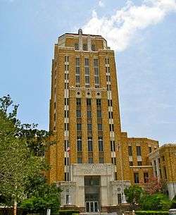
The Jefferson County Courthouse in Beaumont. The Art Deco-style building was added to the National Register of Historic Places on June 17, 1982. The top five floors once served as the County Jail. | ||
| ||
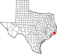 Location in the U.S. state of Texas | ||
 Texas's location in the U.S. | ||
| Founded | 1837 | |
| Seat | Beaumont | |
| Largest city | Beaumont | |
| Area | ||
| • Total | 1,113 sq mi (2,883 km2) | |
| • Land | 876 sq mi (2,269 km2) | |
| • Water | 236 sq mi (611 km2), 21% | |
| Population (est.) | ||
| • (2015) | 254,308 | |
| Congressional district | 14th | |
| Time zone | Central: UTC-6/-5 | |
| Website |
www | |

Jefferson County is a county located in the U.S. state of Texas. As of the 2010 census, the population was 252,273.[1] The county seat of Jefferson County is Beaumont.[2] The county was established in 1835 as a municipality of Mexico and was organized as a county in 1837.[3][4] It is named for U.S. president Thomas Jefferson.[4]
Jefferson County is part of the Beaumont–Port Arthur, TX Metropolitan Statistical Area and has the highest population of the four county MSA. It is located in Southeast Texas.
Geography
According to the U.S. Census Bureau, the county has a total area of 1,113 square miles (2,880 km2), of which 876 square miles (2,270 km2) is land and 236 square miles (610 km2) (21%) is water.[5]
Jefferson County is located on the plains of the Texas Gulf Coast in the southeastern part of the state. The county is bounded on the north by Pine Island Bayou, on the northeast by the Neches River, and on the east by Sabine Lake and the mouth of the Sabine River, a natural outlet called Sabine Pass. The southern part of the county is largely marshland, much of which is contained within Sea Rim State Park, reaching to the storm-battered beach at the Gulf of Mexico.
Major highways
 Interstate 10

 U.S. Highway 69/U.S. Highway 96/U.S. Highway 287
 U.S. Highway 90
 State Highway 73
 State Highway 82
 State Highway 87
 State Highway 105
 State Highway 124
 State Highway 326
 State Highway 347
Adjacent counties and parishes
- Hardin County (north)
- Orange County (northeast)
- Chambers County (southwest)
- Liberty County (northwest)
- Cameron Parish, Louisiana (east)
National protected areas
- Big Thicket National Preserve (part)
- McFaddin National Wildlife Refuge
- Texas Point National Wildlife Refuge
Demographics
| Historical population | |||
|---|---|---|---|
| Census | Pop. | %± | |
| 1850 | 1,836 | — | |
| 1860 | 1,995 | 8.7% | |
| 1870 | 1,906 | −4.5% | |
| 1880 | 3,489 | 83.1% | |
| 1890 | 5,857 | 67.9% | |
| 1900 | 14,239 | 143.1% | |
| 1910 | 38,182 | 168.2% | |
| 1920 | 73,120 | 91.5% | |
| 1930 | 133,391 | 82.4% | |
| 1940 | 145,329 | 8.9% | |
| 1950 | 195,083 | 34.2% | |
| 1960 | 245,659 | 25.9% | |
| 1970 | 244,773 | −0.4% | |
| 1980 | 250,938 | 2.5% | |
| 1990 | 239,397 | −4.6% | |
| 2000 | 252,051 | 5.3% | |
| 2010 | 252,273 | 0.1% | |
| Est. 2015 | 254,308 | [6] | 0.8% |
| U.S. Decennial Census[7] 1850–2010[8] 2010–2014[1] | |||
As of the census[9] of 2000, there were 252,051 people, 92,880 households, and 63,808 families residing in the county. The population density was 279 people per square mile (108/km²). There were 102,080 housing units at an average density of 113 per square mile (44/km²). The racial makeup of the county was 57.24% White, 33.74% Black or African American, 0.34% Native American, 2.89% Asian, 0.03% Pacific Islander, 4.26% from other races, and 1.50% from two or more races. 10.53% of the population were Hispanic or Latino of any race. 8.3% were of American, 7.2% French, 6.2% German, 5.8% English and 5.3% Irish ancestry according to Census 2000.
There were 92,880 households out of which 33.00% had children under the age of 18 living with them, 48.40% were married couples living together, 16.20% had a female householder with no husband present, and 31.30% were non-families. 27.30% of all households were made up of individuals and 11.00% had someone living alone who was 65 years of age or older. The average household size was 2.55 and the average family size was 3.12.
In the county, the population was spread out with 25.90% under the age of 18, 10.00% from 18 to 24, 29.30% from 25 to 44, 21.10% from 45 to 64, and 13.60% who were 65 years of age or older. The median age was 35 years. For every 100 females there were 101.10 males. For every 100 females age 18 and over, there were 100.20 males.
The median income for a household in the county was $34,706, and the median income for a family was $42,290. Males had a median income of $36,719 versus $23,924 for females. The per capita income for the county was $17,571. About 14.60% of families and 17.40% of the population were below the poverty line, including 24.60% of those under age 18 and 11.80% of those age 65 or over.
Government and politics
State representation
The Texas Department of Criminal Justice operates the Gist Unit, a state jail,[10] the Stiles Unit, a prison,[11] and the Leblanc Unit, a pre-release facility, in an unincorporated area of Jefferson County.[12]
In addition the Texas Youth Commission operated the Al Price State Juvenile Correctional Facility in an unincorporated area,[13] within the Mid County region.[14] The TYC announced that the facility will close by August 31, 2011.[15]
Jefferson County was represented from 1999 to 2015 in the Texas House of Representatives by the Republican Allan Ritter, a businessman from Nederland.[16] On January 13, 2015, Republican Dade Phelan of Beaumont succeeds Ritter, who did not seek reelection in 2014.
Federal representation
The Federal Bureau of Prisons operates the Beaumont Federal Correctional Complex in an unincorporated area in Jefferson County.[17]
Presidential elections
Jefferson County is one of the more traditionally Democratic counties in Texas. Although the county had been slowly trending Republican for decades it had not supported a Republican for president since 1972, until Donald Trump won it in 2016.
| Year | GOP | DEM |
|---|---|---|
| 2016 | 48.92% 42,828 | 48.44% 42,404 |
| 2012 | 48.73%43,242 | 50.34% 44,668 |
| 2008 | 48.42%42,905 | 50.76% 44,888 |
| 2004 | 48.38% 44,412 | 51.25% 47,050 |
| 2000 | 46.39% 40,319 | 52.25% 45,409 |
In 2004, Jefferson was one of only 18 counties in Texas that gave Senator John Kerry a majority of the popular vote. Kerry received 47,050 votes while George W. Bush received 44,412. In 2008, Barack Obama won 51.25% of the vote and 44,888 votes. John McCain won 48.38% of the vote and 42,905 votes. Other candidates received 1% of the vote.[18] The trend continued in 2012 when Barack Obama won Jefferson County with 50.34% of the vote going to him, while 48.73% went to Mitt Romney.
Economy
Conquest Airlines, which began in April 1988, had its headquarters on the grounds of Southeast Texas Regional Airport in an unincorporated area in the county.[19][20] Conquest planned to move its headquarters to Austin, Texas in the beginning of 1990.[21] In 1989 Conquest moved its corporate headquarters, 78 employees, and six aircraft to Austin.[22]
Education
Beaumont is home to Lamar University, a public research university with an enrollment of 14,889 students as of the fall 2014 semester offering 96 undergraduate, 50 master's, and eight doctoral degree programs.[23] Port Arthur is home to Lamar State College–Port Arthur, offering two year degrees and one year certifications including 34 associate degrees and 24 technical programs. Fall, 2014 enrollment totaled 2,075 students.[24]
Communities
Cities
- Beaumont (county seat)
- Bevil Oaks
- China
- Groves
- Nederland
- Nome
- Port Arthur (small part in Orange County)
- Port Neches
- Taylor Landing
Census-designated places
Unincorporated areas
See also
References
- 1 2 "State & County QuickFacts". United States Census Bureau. Retrieved December 18, 2013.
- ↑ "Find a County". National Association of Counties. Retrieved 2011-06-07.
- ↑ "Jefferson County". Texas Almanac. Texas State Historical Association. Retrieved June 20, 2015.
- 1 2 Diana J. Kleiner (June 15, 2010). "Jefferson County". Handbook of Texas Online. Texas State Historical Association. Retrieved June 20, 2015.
- ↑ "2010 Census Gazetteer Files". United States Census Bureau. August 22, 2012. Retrieved May 2, 2015.
- ↑ "County Totals Dataset: Population, Population Change and Estimated Components of Population Change: April 1, 2010 to July 1, 2015". Retrieved July 2, 2016.
- ↑ "U.S. Decennial Census". United States Census Bureau. Retrieved May 2, 2015.
- ↑ "Texas Almanac: Population History of Counties from 1850–2010" (PDF). Texas Almanac. Retrieved May 2, 2015.
- ↑ "American FactFinder". United States Census Bureau. Retrieved 2011-05-14.
- ↑ "Gist Unit." Texas Department of Criminal Justice. Retrieved on January 11, 2010.
- ↑ "Stiles Unit." Texas Department of Criminal Justice. Retrieved on January 11, 2010.
- ↑ "Leblanc Unit." Texas Department of Criminal Justice. Retrieved on January 11, 2010.
- ↑ "Facility Address List." Texas Youth Commission. Retrieved on July 31, 2011.
- ↑ Moore, Amy. "Al Price one of three juvenile facilities to close." The Beaumont Enterprise. Friday June 3, 2011. Retrieved on February 28, 2012.
- ↑ "TYC Announces Closure of Three Facilities." Texas Youth Commission. Retrieved on July 3, 2011.
- ↑ "Allan Ritter's Biography". votesmart.org. Retrieved February 20, 2014.
- ↑ "FCI Beaumont Low Contact Information." Federal Bureau of Prisons. Retrieved on January 11, 2010.
- ↑ http://www.uselectionatlas.org/RESULTS/statesub.php?year=2008&fips=48245&f=1&off=0&elect=0
- ↑ Patoski, Joe Nick. "Filling a Niche." Texas Monthly. November 1989. 82.
- ↑ "SEC News Digest." Securities and Exchange Commission. March 8, 1989. 6 (6/8). Retrieved on October 26, 2009.
- ↑ Reynolds, Stephanie. "These commercials aren't just for peanuts. (Conquest Airlines ads produced by Television Group)." Austin Business Journal. July 30, 1990. Retrieved on October 24, 2009.
- ↑ De Marban, Alex. "Let Them Eat Cake." The Austin Chronicle. May 5, 1995. Retrieved on October 26, 2009.
- ↑ "Lamar University". Texas State University System. Retrieved January 15, 2015.
- ↑ "Lamar State College-Port Arthur". Texas State University System. Retrieved January 15, 2015.
External links
- Jefferson County government's website
- Jefferson County in Handbook of Texas Online at the University of Texas
 |
Liberty County | Hardin County | Orange County | |
| |
Cameron Parish, Louisiana | |||
| ||||
| | ||||
| Chambers County | Gulf of Mexico |
Municipalities and communities of Jefferson County, Texas, United States | ||
|---|---|---|
| Cities | | |
| CDPs | ||
| Other unincorporated communities | ||
| Footnotes | ‡This populated place also has portions in an adjacent county or counties | |

Coordinates: 29°52′N 94°08′W / 29.86°N 94.14°W