Weatherford, Texas
| Weatherford, Texas | |
|---|---|
| City | |
|
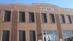
Old City Hall | |
| Nickname(s): Cutting Horse Capital of the World, Peach Capital of Texas | |
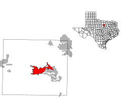
 Location of Weatherford within Parker County, Texas. | |
 | |
| Coordinates: 32°45′33″N 97°47′6″W / 32.75917°N 97.78500°WCoordinates: 32°45′33″N 97°47′6″W / 32.75917°N 97.78500°W | |
| Country |
|
| State |
|
| County | Parker |
| Government | |
| • Type | Council-Manager |
| • City Council |
Mayor Craig Swancy Waymon Hamilton Kevin Cleveland Heidi Wilder Jeff Robinson |
| • City Manager | Sharon Hayes |
| Area | |
| • Total | 22.7 sq mi (58.7 km2) |
| • Land | 20.9 sq mi (54.1 km2) |
| • Water | 1.8 sq mi (4.6 km2) |
| Elevation | 1,053 ft (321 m) |
| Population (2010) | |
| • Total | 25,250 |
| • Density | 910/sq mi (351.3/km2) |
| Time zone | CST (UTC-6) |
| • Summer (DST) | CDT (UTC-5) |
| ZIP codes | 76085-76088 |
| Area code(s) | 817 |
| FIPS code | 48-76864[1] |
| GNIS feature ID | 1376666[2] |
| Website | WeatherfordTX.gov |


Weatherford is a city in Parker County, Texas, United States. The population was 25,250 at the 2010 census. It is the county seat.
Geography
Weatherford is located 25 miles (40 km) west of Fort Worth on Interstate 20. It is the county seat for Parker County.
According to the United States Census Bureau, the city has a total area of 22.7 square miles (59 km2) of which 20.9 square miles (54 km2) of it is land and 1.8 square miles (4.7 km2) of it (7.86%) is water.
Demographics
| Historical population | |||
|---|---|---|---|
| Census | Pop. | %± | |
| 1880 | 2,046 | — | |
| 1890 | 3,369 | 64.7% | |
| 1900 | 4,786 | 42.1% | |
| 1910 | 5,074 | 6.0% | |
| 1920 | 6,203 | 22.3% | |
| 1930 | 4,912 | −20.8% | |
| 1940 | 5,924 | 20.6% | |
| 1950 | 8,093 | 36.6% | |
| 1960 | 9,759 | 20.6% | |
| 1970 | 11,750 | 20.4% | |
| 1980 | 12,049 | 2.5% | |
| 1990 | 14,804 | 22.9% | |
| 2000 | 19,000 | 28.3% | |
| 2010 | 25,250 | 32.9% | |
| Est. 2015 | 28,742 | [3] | 13.8% |
The 2008 census for the population of the City of Weatherford, Texas is 26,686 with a population density of 1,175.59 people per square mile. The population grew by 40.5% from 2000 to 2008. The racial makeup of the city in 2008 is 85.50% White, 10.20% Hispanic, 2.10% Black, 1.30% American Indian, 0.70% Asian, 4.10% other. Weatherford's average household size is 2.5.
The average income per household was $50,924, in the year 2007. The estimated 2007 city capita was $26,380.
According to the 1999 census, 25.0% of the population is under the age of 18, 10.6% is 18 to 24, 26.3% is 25 to 44, 21.8% is 45 to 64, and 16.4% is 65 years of age or older. The median age is 36 years.
Education
The City of Weatherford is served by the Weatherford Independent School District and Weatherford College.
Weatherford ISD
Weatherford ISD has classes from pre-kindergarten through high school serving 7,200 students throughout 254 square miles (660 km2) at 11 campuses.
Weatherford College
Weatherford College is a 145-year-old community college. There are more than 35 study areas and 19 professional/technical programs. Financial aid packages and scholarships are also available. The College was originally built by Masons and was one of the first in Texas.
History
Beginnings
In 1855, Parker County was created by the Texas State Legislature and named for pioneer and State Representative Isaac Parker. Parker was the uncle of Cynthia Ann Parker, a little girl who was stolen from her home by Indians during the Texas Revolution. Cynthia Ann lived among the Comanche and became the mother of Chief Quanah Parker. Later, when she was overtaken in flight with an Indian raiding party, Isaac Parker recognized her as his long-lost niece.
The Town of Weatherford was named for the State Senator for this district, Thomas Jefferson Weatherford (1811-1867) of Dallas. According to his cousin, Senator Weatherford never set foot in the town.
The first settlers had arrived less than ten years earlier. There were many Native American attacks between the years of 1846 and 1874. Several headstones in Parker County read "Killed by Indians."
The railroad arrived in June 1880. The Santa Fe Depot (which houses the Weatherford Chamber of Commerce) was built in 1908 under Jim Crow laws, with waiting rooms segregated and separated by the ticket office.
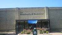
In 1895, the town’s still existing daily newspaper, the Weatherford Democrat, began publication. The Weatherford Telegram began publishing as a weekly newspaper in 2006.
Western Heritage
Cattle drover Oliver Loving is buried in Weatherford’s Greenwood Cemetery. After being attacked by Indians in New Mexico in 1867, Loving’s dying wish to his friend, Charles Goodnight, was to be buried at his home, Parker County. Goodnight brought the body back six hundred miles by wagon for burial. The story is the inspiration behind Texas author Larry McMurtry’s novel, Lonesome Dove.
A year earlier, Goodnight had invented the first chuckwagon which catered to cowboys on a cattle drive that would later become known as the Goodnight-Loving Trail.
Bose Ikard, who served with Goodnight and for whom the McMurtry character “Deets” was modeled, was also laid to rest in the Greenwood Cemetery.
Religion
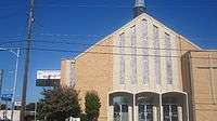
Weatherford lies in a geographic region commonly referred to as the "Bible Belt". As such, it is home to churches of several Christian traditions including Disciples of Christ, Church of Christ, Baptist, Pentecostal, Methodist, Presbyterian, Lutheran, Anglican, Episcopal, Mormon and Catholic. There are no worship centers for any other major religions within the city limits. Practitioners of other religions commonly travel to nearby Fort Worth to attend religious services.
Peach Capital of Texas
The city was named by the Texas Legislature as the Peach Capital of Texas due to the peaches produced by area growers. The peach is celebrated each year at the Parker County Peach Festival, which is Weatherford’s largest event and one of the best-attended festivals in Texas.
Cutting Horse Capital of the World
Weatherford is known as the Cutting Horse Capital of the World.
Historic buildings
Weatherford has a number of historic homes and buildings. More than 60 Queen Anne, Victorian, and other architecturally significant homes built at the turn of the 20th century sit along the tree-lined avenues. Several of these homes are open for tours, arranged by the Parker County Heritage Society, during the Christmas season.
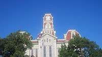
Another landmark is the Second Empire style Parker County Courthouse, which is located in the geographical center of the county in downtown Weatherford. The building is surrounded by other buildings which served other purposes at the turn of the 20th century, including saloons and cat-houses. In recent years, both the interior and exterior of the courthouse structure have been restored to its original character and attractiveness.
Notable people
- Major League Baseball pitcher Hippo Vaughn, who pitched for the Chicago Cubs 1913-21.
- Major League Baseball pitcher Zach Britton, who pitched for the Baltimore Orioles.
- Thomas Stevenson Drew, the third governor of Arkansas, lived for a time in Weatherford before he relocated to Hood County, Texas.
- Joe B. Frantz, historian on the faculty of the University of Texas at Austin, was born in Dallas but reared in Weatherford.
- Texas author Edwin Lanham was reared in Weatherford, the slightly veiled setting for his most critically acclaimed work "The Wind Blew West."
- Weatherford is also the birthplace and was the home of Mary Martin, a Broadway star, known for her portrayal of Peter Pan. Her son, Larry Hagman, became a TV star, best known as J.R. Ewing on the television melodrama Dallas. Hagman made appearances for special occasions and to assist many Weatherford charities as his brother still lives in Weatherford.
- William Hood Simpson (May 18, 1888 – August 15, 1980), lieutenant general, commanded the U.S. Ninth Army in northern Europe, during World War II.
- Former Speaker of the United States House of Representatives Jim Wright grew up in Weatherford and wrote a book about his youth, Weatherford Days…a Time of Learning.
- Bob Tallman, nationally known rodeo announcer, operates a ranch in Parker County near Weatherford.
- Mary Couts Burnett (1856–1924), philanthropist.
- John Cunyus, editor and publisher at Searchlight Press and director of The Latin Testament Project, served Central Christian Church of Weatherford as Pastor between 1988 and 1992.[5]
- Baltimore Ravens defensive lineman Kapron Lewis-Moore.
Two state representatives
Parker County has been represented in the Texas State House since 1985 by two Republicans, Richard F. "Ric" Williamson (1952–2007) and Phillip Stephen King. Originally a Democrat, Williamson switched parties and served until 1999, when he was succeeded by King, one of the more conservative members of the legislature. Williamson's old friend and former legislative colleague, Governor Rick Perry, appointed him to the Texas Transportation Commission, of which he became the chairman in 2004. Williamson died of a third heart attack on December 30, 2007. He had been a champion of Perry's controversial Trans-Texas Corridor toll road project.
Climate
The climate in this area is characterized by relatively high temperatures and evenly distributed precipitation throughout the year. The Köppen Climate System describes the weather as humid subtropical, and uses the abbreviation Cfa.[6]
| Climate data for Weatherford, Texas | |||||||||||||
|---|---|---|---|---|---|---|---|---|---|---|---|---|---|
| Month | Jan | Feb | Mar | Apr | May | Jun | Jul | Aug | Sep | Oct | Nov | Dec | Year |
| Average high °C (°F) | 12 (54) |
14 (58) |
19 (67) |
24 (75) |
28 (82) |
33 (91) |
35 (95) |
36 (96) |
31 (88) |
26 (78) |
18 (65) |
13 (56) |
24 (76) |
| Average low °C (°F) | −1 (31) |
1 (34) |
6 (42) |
11 (51) |
16 (60) |
20 (68) |
22 (72) |
22 (71) |
18 (64) |
11 (52) |
5 (41) |
1 (33) |
11 (52) |
| Average precipitation mm (inches) | 46 (1.8) |
56 (2.2) |
64 (2.5) |
86 (3.4) |
119 (4.7) |
84 (3.3) |
56 (2.2) |
56 (2.2) |
80 (3) |
81 (3.2) |
56 (2.2) |
50 (2) |
833 (32.8) |
| Source: Weatherbase[7] | |||||||||||||
References
- ↑ "American FactFinder". United States Census Bureau. Retrieved 2008-01-31.
- ↑ "US Board on Geographic Names". United States Geological Survey. 2007-10-25. Retrieved 2008-01-31.
- ↑ "Annual Estimates of the Resident Population for Incorporated Places: April 1, 2010 to July 1, 2015". Retrieved July 2, 2016.
- ↑ "Census of Population and Housing". Census.gov. Retrieved June 4, 2015.
- ↑ Year Book and Director, 1990, of the Christian Church (Disciples of Christ), pg. 568
- ↑ Climate Summary for Weatherford, Texas
- ↑ "Weatherbase.com". Weatherbase. 2013. Retrieved on September 8, 2013.
External links
- City of Weatherford
- Weatherford Chamber of Commerce
- View Historic photos of Weatherford from the Weatherford College Library, hosted by the Portal to Texas History
- Weatherford Public Library provides free online access to full-text historical documents, photos, and oral histories through the Preserving and Expanding Access to Culture and History (PEACH) project.
Municipalities and communities of Parker County, Texas, United States | ||
|---|---|---|
| Cities | 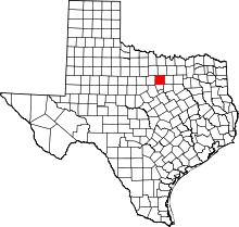 | |
| Towns | ||
| CDPs | ||
| Other unincorporated communities | ||
| Footnotes | ‡This populated place also has portions in an adjacent county or counties | |
