Mesquite, Texas
| Mesquite, Texas | |
|---|---|
| City | |
|
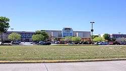
AMC Theatre in Mesquite. | |
 Location within Dallas County and the state of Texas | |
| Coordinates: 32°46′58″N 96°36′36″W / 32.78278°N 96.61000°WCoordinates: 32°46′58″N 96°36′36″W / 32.78278°N 96.61000°W | |
| Country |
|
| State |
|
| Counties | Dallas, Kaufman |
| Government | |
| • Type | Council-Manager |
| • City Mayor | Stan Pickett |
| • City Manager | Cliff Keheley |
| Area | |
| • Total | 46.2 sq mi (119.6 km2) |
| • Land | 46.0 sq mi (119.2 km2) |
| • Water | 0.2 sq mi (0.4 km2) |
| Elevation | 495 ft (151 m) |
| Population (2013) | |
| • Total | 143,484 |
| • Density | 3,216/sq mi (1,241.7/km2) |
| Time zone | CST (UTC-6) |
| • Summer (DST) | CDT (UTC-5) |
| ZIP codes | 75149, 75150, 75181, |
| Area code(s) | 214, 469, 972 |
| FIPS code | 48-47892[1] |
| GNIS feature ID | 1341400[2] |
| Website |
cityofmesquite |
Mesquite is a city and an eastern suburb of Dallas, Texas. Most of the city is located in Dallas County. As of the 2010 census, the population was 144,416 making it the twentieth most populous city in the state of Texas.[3]
History
The city was founded on March 14, 1878, on land along the Texas & Pacific Railroad outside of Dallas. The railroad, which ran from Dallas to Shreveport, Louisiana, began stopping at the newly created town shortly thereafter, and the city began to grow around the railroad. The city was officially incorporated on December 3, 1887.
Mesquite prospered through the late 19th century and early 20th century as a farming community growing cotton, hay, corn and sugar and using the railroad to ship raw goods. The town remained predominantly agrarian until after World War II when the suburban boom also took root in Mesquite. The city's population rapidly grew from 1,696 in the 1950 census to 27,526 in 1960 and 55,131 in 1970.
In 1958, the Mesquite ProRodeo was established, and in 1959, Big Town Mall opened as the first air conditioned shopping mall in the United States. The mall was demolished in the summer of 2006.
By 1970, LBJ Freeway (I-635) was constructed, connecting Mesquite to its neighbors, Garland to the north and Balch Springs to the south. Also in 1971, Town East Mall was constructed. The mall was used by director Ron Howard to film portions of the movie Cotton Candy in 1978. The mall's associated traffic and shops would continue to grow the town. By the 1990 census, the city had grown to 101,484 people, nearly twice the population twenty years earlier.
In 1986, the Mesquite Arena opened its doors as the new home for the Mesquite ProRodeo. By 1998, the facility was expanded to include a Convention Center, Exhibition Hall and a Hampton Inn & Suites.
2011 saw Mesquite pass a law that allows beer and wine sales in the city. The measure had been considered several times for many years, but was always blocked by strong protest against the proposed sales. It was one of the few cities without beer and wine sales in eastern Dallas County before the law came into effect.
Geography
Mesquite is located at 32°46′58″N 96°36′36″W / 32.782878°N 96.609862°W (32.782878, -96.609862).[4]
According to the United States Census Bureau, the city has a total area of 46.2 square miles (119.6 km2), of which 46.0 square miles (119.2 km2) is land and 0.15 square miles (0.4 km2), or 0.33%, is water.[5]
| Mesquite, Texas | ||||||||||||||||||||||||||||||||||||||||||||||||||||||||||||
|---|---|---|---|---|---|---|---|---|---|---|---|---|---|---|---|---|---|---|---|---|---|---|---|---|---|---|---|---|---|---|---|---|---|---|---|---|---|---|---|---|---|---|---|---|---|---|---|---|---|---|---|---|---|---|---|---|---|---|---|---|
| Climate chart (explanation) | ||||||||||||||||||||||||||||||||||||||||||||||||||||||||||||
| ||||||||||||||||||||||||||||||||||||||||||||||||||||||||||||
| ||||||||||||||||||||||||||||||||||||||||||||||||||||||||||||
Climate
On average, the warmest month is July. The highest recorded temperature was 112 °F in 1980. The average coolest month is January. The lowest recorded temperature was 1 °F in 1989.
May is the average wettest month. Mesquite is part of the humid subtropical region.
Government
Local government
The City Council consists of a Mayor and six Councilmembers. The City Manager and management staff is:[6]
| City Department | Director |
|---|---|
| City Manager | Cliff Keheley |
| Deputy City Manager | Jerry Dittman |
| Assistant City Manager | Jeff Jones |
| Managing Director of Community Services | Valerie Bradley |
| Managing Director of Financial Services | Ted Chinn |
| Fire Chief | Mark Kerby |
| Police Chief | Charles Cato |
| City Attorney | B.J. Smith |
| City Secretary | Sonja Land |
| Director of Airport | Cynthia Godfrey |
| Director of Finance | Debbie Mol |
| Director of Human Resources | Rick French |
| Director of Information technology | Zak Lajoie |
| Director of Library Services | Virginia Mundt |
| Director of Neighborhood Services | Raymond Rivas |
| Director of Parks & Recreation | Elizabeth Harrell |
| Director of Planning & Development | Richard Gertson |
| Director of Public Works | Tim James |
The City of Mesquite provides services and programs, including Animal Services,[7] the Mesquite Arts Centre,[8] Historic Mesquite,[9] Keep Mesquite Beautiful,[10] and Parks and Recreation.[11]
Education
Public schools

Mesquite Independent School District provides primary and secondary (K-12) education to most areas of Mesquite. A small portion of Mesquite is served by Dallas Independent School District. While another small area in Kaufman County is within the Forney Independent School District, the section has no residents. Mesquite also serves an area of Balch Springs.
In addition to numerous elementary and middle schools, Mesquite is served by five high schools: Mesquite High School, North Mesquite High School, West Mesquite High School, Poteet High School, and Horn High School.
Private schools
Dallas Christian School is located in Mesquite.
Colleges and universities
Higher education is provided by three institutions. Eastfield College provides undergraduate degrees and continuing education credits as part of the Dallas County Community College District. The Texas A&M University–Commerce Mesquite Metroplex Center provides graduate-level courses and degrees in a variety of fields. Columbia College-Mesquite Campus is located on the Eastfield College campus. It is a private, nonprofit institution that was founded in Columbia, Missouri, in 1851. It provides bachelor's and master's degree programs.
Transportation
Mesquite is served by a publicly owned and operated airport, Mesquite Metro Airport.[12] The airport includes a 6,000-foot (1,800 m) lighted runway with ILS. General aviation comprises approximately 75% of daily operations, while commercial aviation comprises the rest.[13] Mesquite Metro Airport is popular among transient aircraft due to its location near Dallas and favorable fuel prices.[14]
Two other nearby airports, Dallas/Fort Worth International Airport and Dallas Love Field, provide regular commercial passenger service to the region. Love Field is approximately 15 miles (24 km) from Mesquite; DFW Airport is approximately 30 miles (48 km) from Mesquite.
Mesquite is not a member of Dallas Area Rapid Transit, but on April 12, 2011 The DART Board changed its policy to permit DART to contract with non-member cities for services, such as passenger rail and express service. The city and DART staffs have developed a coordinated plan to have a weekday commuter service in operation between the Hanby Stadium visitor parking lot and the DART's Green Line Lawnview Station. This route opened March 12, 2012. The city also operates its own paratransit service for elderly and disabled residents.[15]
Union Pacific Railroad operates an intermodal facility for its freight rail service as part of the Skyline Industrial Park. The recent expansion of this intermodal facility won a Silver award in the Industrial Paving Category by the American Concrete Pavement Association.[16]
Highways
Mesquite is served by three interstate highways, one US highway, and one state highway. Interstates 20, 30, and 635, US Highway 80, and Texas State Highway 352 all pass through Mesquite. Belt Line Road also passes through Mesquite and serves as a major road.
Demographics
| Historical population | |||
|---|---|---|---|
| Census | Pop. | %± | |
| 1890 | 135 | — | |
| 1900 | 406 | 200.7% | |
| 1910 | 687 | 69.2% | |
| 1920 | 674 | −1.9% | |
| 1930 | 729 | 8.2% | |
| 1940 | 1,045 | 43.3% | |
| 1950 | 1,696 | 62.3% | |
| 1960 | 27,526 | 1,523.0% | |
| 1970 | 55,131 | 100.3% | |
| 1980 | 67,053 | 21.6% | |
| 1990 | 101,484 | 51.3% | |
| 2000 | 124,523 | 22.7% | |
| 2010 | 139,824 | 12.3% | |
| Est. 2015 | 144,788 | [17] | 3.6% |
As of the 2010 Census:
- Total population: 139,824
- Total households: 48,390
- Total families: 35,444
- Population density: 3,216 people/mi2 (1,241.7/km2)
- Housing density: 1,129.4/mi2 (435.8/mi2)
- Racial makeup:
- 59.0% White (41.6% non-Hispanic White)
- 21.8% African American
- 0.84% Native American
- 3.24% Asian
- 0.07% Pacific Islander
- 3.12% two or more races
- 31.6% Hispanic or Latino origin[3]
There were 48,390 households in the city, out of which 39.1% had children under the age of 18 living with them, 48.3% were headed by married couples living together, 18.9% had a female householder with no husband present, and 26.8% were non-families. 22.4% of all households were made up of individuals, and 6.4% were someone living alone who was 65 years of age or older. The average household size was 2.88, and the average family size was 3.38.[3]
In the city 29.8% of the population were under the age of 18, 10.1% were 18 to 24 years old, 27.9% were 25 to 44, 23.7% were 45 to 64, and 8.6% were 65 years of age or older. The median age was 32.3 years. For every 100 females there were 91.3 males. For every 100 females age 18 and over, there were 86.4 males.[3]
As of the 2000 Census:
- Per capita income: $20,890
- Median household income: $30,424
- Median family income: $36,357
- Median income (males): $37,756
- Median income (females): $29,905
About 5.0% of families and 6.8% of the population were below the poverty line, including 8.8% of those under age 18 and 6.6% of those age 65 or over.
Indian Americans
Mesquite has a group of Indian Americans, mostly Kerala-origin Indian Christians.[19] Their settlement, one of the earliest of the Indian Americans in the DFW area, was influenced by proximity to Dallas-based hospitals such as Baylor University Medical Center at Dallas and Parkland Hospital as well as having initial low income and difficulties moving to mostly-white northern suburbs; people from Kerala have relatively dark skin, and at the time this made them potential discrimination targets.[20]
Economy
According to the City's 2008 Comprehensive Annual Financial Report,[21] the top employers in the city are:
| # | Employer | # of Employees | % of Total City Employment |
|---|---|---|---|
| 1 | United Parcel Service Inc. | 3,000 | 4.22% |
| 2 | Dallas Regional Medical Center | 1,150 | 1.62% |
| 3 | City of Mesquite | 1,054 | 1.48% |
| 4 | Sears | 450 | 0.63% |
| 5 | Texas Dept of Transportation - Dallas District | 425 | 0.60% |
| 6 | Baker Drywall LTD | 400 | 0.56% |
| 7 | Dallas County Community College | 400 | 0.56% |
| 8 | Christian Care Center | 400 | 0.56% |
| 9 | Integra Color | 383 | 0.54% |
| 10 | Pepsi-Cola Metro Bottling Co Inc | 325 | 0.46% |
Neighborhoods
Neighborhoods include:
- Lawson
- Park View
- Edgemont Park
- Creek Crossing
- Creek Crossing II
- Falcon's Lair
- Falcon's Ridge
- Pecan Creek
- Rollingwood Hills
- Skyline
- Pasadena Gardens
- Original Town
- Melton
- Tealwood
- Northridge
- Quail Hollow
- Broadmoor Estates
- Wildwood
- Valley Creek
- Meadowview
- Palos Verdes
Constructions
- Mesquite Tower is a lattice tower of unusual design.
- Town East Tower is the tallest inhabited building in Mesquite, standing seven stories high.
Notable people
- Dave Abruzzese, ex-drummer for Pearl Jam
- Taylor Gabriel professional football player, wide receiver for the Atlanta Falcons
- Tarell Brown, professional football player who currently plays for the New England Patriots, (Injured Reserved),played for San Francisco 49ers, Oakland Raiders, and a member of the Texas Longhorns 2005 National Championship team, graduate of North Mesquite High School
- Melissa Archer, actress on One Life to Live
- Joe Bowden, former professional football player for the Houston Oilers, Tennessee Titans, and Dallas Cowboys
- John D. Carmack, game programmer and the co-founder of id Software.[22] Lead programmer of the id computer games Wolfenstein 3D, Doom, Quake, their sequels and the Commander Keen series of games and is the current the CTO of Oculus VR.
- Ray Cunningham, former professional baseball player for the St. Louis Cardinals
- Terry Fator, singer and ventriloquist, winner of America's Got Talent in 2007[23]
- Don Gay, eight-time PRCA world champion bullrider
- Todd Graham, college football coach; current head coach of Arizona State University
- Jerry Hall, actress and model, former wife of Mick Jagger and mother of four of his children
- Micah Xavier Johnson, former soldier of the United States Army Reserves and perpetrator of the 2016 shooting of Dallas police officers
- Taylor Lipsett, gold medalist in Sled Hockey at the 2010 Winter Paralympic Games in Vancouver. He led Team USA in goals, with 5 goals in 5 games, and added 2 assists for a total of 7 points.
- Sean Lowe, former professional baseball player for the Chicago White Sox, St. Louis Cardinals, Pittsburgh Pirates, Colorado Rockies, and Kansas City Royals
- Bryan Massey, actor and writer
- Taylor Parks, actress and singer, best known as Little Inez in the 2007 film Hairspray[24]
- Greg Vaughan, actor on General Hospital
- Quincy Acy, professional basketball player for the Toronto Raptors, Sacramento Kings, and currently, the New York Knicks.
- Craig Wayne Boyd, winner of season 7 of The Voice, Coached by Blake Shelton.
- Trevone Boykin, Quarterback For Texas Christian University (senior), Graduated from West Mesquite High School
- Jason Jennings, former professional baseball player for the Colorado Rockies, Houston Astros, and Texas Rangers (baseball).
- Damien Magnifico, professional baseball player for the Milwaukee Brewers.
- Alyssa Edwards, Notable Drag Personality and Contestant on Rupaul's Drag Race.
See also
-
 Dallas-Fort Worth portal
References
- ↑ "American FactFinder". United States Census Bureau. Retrieved 2008-01-31.
- ↑ "US Board on Geographic Names". United States Geological Survey. 2007-10-25. Retrieved 2008-01-31.
- 1 2 3 4 "Profile of General Population and Housing Characteristics: 2010 Demographic Profile Data (DP-1): Mesquite city, Texas". U.S. Census Bureau, American Factfinder. Retrieved January 13, 2012.
- ↑ "US Gazetteer files: 2010, 2000, and 1990". United States Census Bureau. 2011-02-12. Retrieved 2011-04-23.
- ↑ "Geographic Identifiers: 2010 Demographic Profile Data (G001): Mesquite city, Texas". U.S. Census Bureau, American Factfinder. Retrieved January 13, 2012.
- ↑ City of Mesquite AFR Retrieved 2009-08-17
- ↑ https://www.cityofmesquite.com/130/Animal-Services
- ↑ https://www.cityofmesquite.com/158/Arts-Center
- ↑ https://www.cityofmesquite.com/174/Historic-Mesquite-Inc
- ↑ https://www.cityofmesquite.com/175/Keep-Mesquite-Beautiful
- ↑ https://www.cityofmesquite.com/214/Parks-Recreation
- ↑ City of Mesquite web site. Access 10 September 2006
- ↑ City of Mesquite web site. Accessed 9 September 2006
- ↑ AirNav: Mesquite Metro Airport. Accessed 8 September 2006
- ↑ City of Mesquite web site. Accessed 9 September 2006
- ↑ http://www.transystems.com/Home/News-Press/In-The-Spotlight/Archive/Mesquite-Intermodal-Facility-Expansion-Receives-Re.aspx
- ↑ "Annual Estimates of the Resident Population for Incorporated Places: April 1, 2010 to July 1, 2015". Retrieved July 2, 2016.
- ↑ "Census of Population and Housing". Census.gov. Retrieved June 4, 2015.
- ↑ Brettell, Caroline B. '"Big D" Incorporating New Immigrants in a Sunbelt Suburban Metropolis' (Chapter 3). In: Singer, Audrey, Susan Wiley Hardwick, and Caroline Brettell. Twenty-First Century Gateways: Immigrant Incorporation in Suburban America (James A. Johnson metro series). Brookings Institution Press, 2009. ISBN 0815779283, 9780815779285. Start p. 53. CITED: p.64.
- ↑ Brettell, Caroline B. '"Big D" Incorporating New Immigrants in a Sunbelt Suburban Metropolis' (Chapter 3). In: Singer, Audrey, Susan Wiley Hardwick, and Caroline Brettell. Twenty-First Century Gateways: Immigrant Incorporation in Suburban America (James A. Johnson metro series). Brookings Institution Press, 2009. ISBN 0815779283, 9780815779285. Start p. 53. CITED: p.65.
- ↑ City of Mesquite CAFR Retrieved 2009-08-17
- ↑ Biography for John Carmack at the Internet Movie Database
- ↑ http://www.cedarcreekpilot.com/features/local_story_186120320.html Cedar Creek Pilot article
- ↑ http://www2.scholastic.com/browse/article.jsp?id=3746845
External links
- Official website
- Mesquite from the Handbook of Texas Online
Municipalities and communities of Dallas County, Texas, United States | ||
|---|---|---|
| Cities | 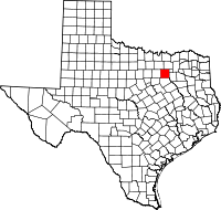 | |
| Towns | ||
| Unincorporated communities | ||
| Historical communities | ||
| Footnotes | ‡This populated place also has portions in an adjacent county or counties | |
Municipalities and communities of Kaufman County, Texas, United States | ||
|---|---|---|
| Cities | 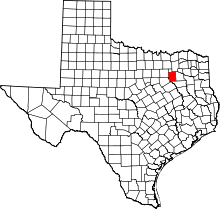 | |
| Towns | ||
| Villages | ||
| CDPs | ||
| Unincorporated communities | ||
| Footnotes | ‡This populated place also has portions in an adjacent county or counties | |

| ||
| ||