Jeff Davis County, Texas
| Jeff Davis County, Texas | |
|---|---|
| County | |
| Jeff Davis County | |
|
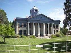
Jeff Davis County Courthouse in Fort Davis | |
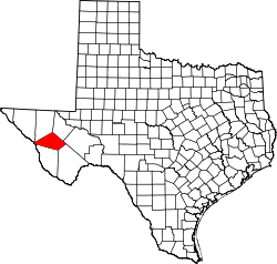 Location in the U.S. state of Texas | |
 Texas's location in the U.S. | |
| Founded | 1887 |
| Named for | Jefferson Davis |
| Seat | Fort Davis |
| Largest community | Fort Davis |
| Area | |
| • Total | 2,265 sq mi (5,866 km2) |
| • Land | 2,265 sq mi (5,866 km2) |
| • Water | 0.08 sq mi (0 km2), 0% |
| Population | |
| • (2010) | 2,342 |
| • Density | 1.0/sq mi (0/km²) |
| Congressional district | 23rd |
| Time zone | Central: UTC-6/-5 |
| Website |
www |
Jeff Davis County is a county in the U.S. state of Texas. As of the 2010 census, its population was 2,342.[1] Its county seat is Fort Davis.[2] The county is named for Jefferson Davis, the 23rd United States Secretary of War and Confederate president.[3] It is one of the nine counties that compose the Trans-Pecos region of West Texas.
The county contains the 270,000-acre (1,100 km2) Texas Davis Mountains American Viticultural Area, though only about 50 acres (0.2 km2) is currently under vine. The McDonald Observatory is located near Fort Davis, and is owned by the University of Texas at Austin.
History
Native Americans
Prehistoric peoples camped at Phantom Lake Spring, in northeastern Jeff Davis County, and may have used the springs for irrigation.[4] Indian pictographs in The Painted Comanche Camp of Limpia Canyon were discovered by the Whiting and Smith Expedition of 1849.[5]
In August 1861, Mescalero Apaches under Chief Nicolas made an attack on Fort Davis, driving off livestock and killing three people. In the ensuing chase by the cavalry, Nicolas ambushed the soldiers, killing them all.[6] September 1868 at Horsehead Hills, a group of volunteer Mexicans and Buffalo Soldiers from Fort Davis attacked and destroyed a Mescalero village to recover captives and stolen livestock. January 1870, a group of soldiers attacked a Mescalero Apache village near Delaware Creek in the Guadalupe Mountains. July 1880 soldiers at Tinaja de las Palmas attacked a group of Mescaleros led by Chief Victorio. August 1880, Buffalo Soldiers ambushed Victorio at Rattlesnake Springs. Victorio retreated to Mexico and was killed in October by Mexican soldiers. The last Indian depredation in the area was at Barry Scobee Mountain in 1881.[7]
Early days
In March 1849 lieutenants William H. C. Whiting and William F. Smith were sent out by Maj. Gen. William J. Worth of the Texas 8th Military Department to look for a route from San Antonio to El Paso del Norte. A second party, led by Dr. John S. Ford and financed by a group of Austin merchants, pioneered a trail that ran north of the Davis Mountains before turning southward toward El Paso. June 1849 Lt. Col. Joseph E. Johnston, attached to Bvt. Maj. Jefferson Van Horne’s battalion, was sent for additional surveying. At El Paso, Horne established Fort Bliss. Texas Ranger Big Foot Wallace escorted the San Antonio-El Paso Mail coach through the mountains.[8] Fort Davis was established in 1854.The land was leased from Surveyor John James at $300 a year. The fort was surrendered to the Confederacy in 1861, and abandoned in 1862 after Confederate defeat at Glorieta Pass, New Mexico, but was re-occupied by U.S. troops July 1, 1867.[9][10]
County establishment and growth
The legislature established Jeff Davis County on March 15, 1887. Fort Davis was named county seat.[10] Cattle ranchers began operating in the county in the 1880s. The towns of Valentine[11] and Chispa[12] became supply centers for the ranchers and later railroad stops.
Fort Davis has always been the county's largest town. By 1970, Madera Springs was known as the smallest town in Texas.[13] Davis Mountains State Park opened to the public in the 1930s.[14]Fort Davis National Historic Site was established in 1961. The Chihuahuan Desert Research Institute arboretum was established in 1974.[15][16]
Geography
According to the U.S. Census Bureau, the county has a total area of 2,265 square miles (5,870 km2), virtually all of which is land.[17] The county is home to the Davis Mountains, the highest mountain range located entirely within the state of Texas.
Protected areas
.jpg)
The county has parks and preserves maintained by federal and state park services as well as the Chihuahuan Desert Research Institute and The Nature Conservancy of Texas. In addition to the properties listed below, The Nature Conservancy has been instrumental in the creation of conservation easements protecting an additional 69,600 acres (28,200 ha) of private property surrounding its preserve.[18]
| Park or preserve | Maintaining authority | Area | Year established |
|---|---|---|---|
| Chihuahuan Desert Nature Center and Botanical Gardens | Chihuahuan Desert Research Institute | 507 acres (205 ha)[19] | 1978[19] |
| Davis Mountains State Park | Texas Parks and Wildlife Department | 2,709 acres (1,096 ha)[20] | 1933[20] |
| Davis Mountains Preserve | The Nature Conservancy of Texas | 33,075 acres (13,385 ha)[18] | 1997[21] |
| Fort Davis National Historic Site | National Park Service | 523 acres (212 ha)[22] | 1961[23] |
Major highways
Adjacent counties and municipios
- Reeves County (north)
- Pecos County (east)
- Brewster County (southeast)
- Presidio County (southwest)
- Guadalupe, Chihuahua, Mexico (west)
- Hudspeth County (northwest)
- Culberson County (north)
Climate
Jeff Davis County predominantly experiences a semi-arid steppe climate with 83.0% of the county classified as cold semi-arid (Köppen BSk) and 0.4% classified as hot semi-arid (Köppen BSh). An additional 16.5% is classified as having a hot arid desert climate (Köppen BWh).[24] Within the county, precipitation increases while daytime and nighttime temperatures generally become milder with increasing elevation. Rainfall is most abundant from May through October. Snowfall is also more abundant at higher elevations despite having higher wintertime average low temperatures.
- Fort Davis
- Coordinates: 30°35′59″N 103°53′13″W / 30.59972°N 103.88694°W
- Elevation: 4,864 feet (1,483 m)[25]
| Climate data for Fort Davis, Texas (Jan 1, 1902–Mar 31, 2013) | |||||||||||||
|---|---|---|---|---|---|---|---|---|---|---|---|---|---|
| Month | Jan | Feb | Mar | Apr | May | Jun | Jul | Aug | Sep | Oct | Nov | Dec | Year |
| Average high °F (°C) | 60.8 (16) |
64.4 (18) |
71.3 (21.8) |
78.9 (26.1) |
85.8 (29.9) |
90.3 (32.4) |
88.4 (31.3) |
87.4 (30.8) |
83.2 (28.4) |
76.9 (24.9) |
67.5 (19.7) |
60.6 (15.9) |
76.29 (24.6) |
| Average low °F (°C) | 28.8 (−1.8) |
31.8 (−0.1) |
37.3 (2.9) |
45.0 (7.2) |
53.4 (11.9) |
60.3 (15.7) |
62.1 (16.7) |
61.0 (16.1) |
55.3 (12.9) |
45.7 (7.6) |
35.9 (2.2) |
29.7 (−1.3) |
45.53 (7.5) |
| Average precipitation inches (mm) | 0.50 (12.7) |
0.46 (11.7) |
0.38 (9.7) |
0.54 (13.7) |
1.31 (33.3) |
1.98 (50.3) |
2.85 (72.4) |
2.91 (73.9) |
2.27 (57.7) |
1.35 (34.3) |
0.54 (13.7) |
0.55 (14) |
15.64 (397.4) |
| Source: Western Regional Climate Center, Desert Research Institute[26] | |||||||||||||
- McDonald Observatory
- Coordinates: 30°42′19″N 104°01′24″W / 30.70528°N 104.02333°W
- Elevation: 6,790 feet (2,070 m)[25]
| Climate data for Mount Locke, Texas (Jan 1, 1935–Mar 31, 2013) | |||||||||||||
|---|---|---|---|---|---|---|---|---|---|---|---|---|---|
| Month | Jan | Feb | Mar | Apr | May | Jun | Jul | Aug | Sep | Oct | Nov | Dec | Year |
| Average high °F (°C) | 53.5 (11.9) |
56.9 (13.8) |
63.7 (17.6) |
71.4 (21.9) |
78.6 (25.9) |
84.5 (29.2) |
82.7 (28.2) |
81.3 (27.4) |
76.6 (24.8) |
70.5 (21.4) |
61.2 (16.2) |
54.4 (12.4) |
69.61 (20.89) |
| Average low °F (°C) | 32.0 (0) |
33.9 (1.1) |
38.2 (3.4) |
45.2 (7.3) |
52.4 (11.3) |
58.2 (14.6) |
58.9 (14.9) |
58.4 (14.7) |
54.4 (12.4) |
48.0 (8.9) |
38.7 (3.7) |
33.6 (0.9) |
45.99 (7.77) |
| Average precipitation inches (mm) | 0.68 (17.3) |
0.49 (12.4) |
0.40 (10.2) |
0.50 (12.7) |
1.63 (41.4) |
2.49 (63.2) |
3.82 (97) |
3.69 (93.7) |
2.95 (74.9) |
1.61 (40.9) |
0.61 (15.5) |
0.60 (15.2) |
19.47 (494.4) |
| Source: Western Regional Climate Center, Desert Research Institute[27] | |||||||||||||
- Valentine
- Coordinates: 30°35′27″N 104°29′29″W / 30.59083°N 104.49139°W
- Elevation: 4,440 feet (1,353 m)[25]
| Climate data for Valentine, Texas (Jun 1, 1978–Mar 31, 2013) | |||||||||||||
|---|---|---|---|---|---|---|---|---|---|---|---|---|---|
| Month | Jan | Feb | Mar | Apr | May | Jun | Jul | Aug | Sep | Oct | Nov | Dec | Year |
| Average high °F (°C) | 60.3 (15.7) |
65.0 (18.3) |
72.0 (22.2) |
80.0 (26.7) |
87.7 (30.9) |
93.8 (34.3) |
92.1 (33.4) |
90.3 (32.4) |
86.0 (30) |
78.9 (26.1) |
68.3 (20.2) |
60.6 (15.9) |
77.92 (25.51) |
| Average low °F (°C) | 27.0 (−2.8) |
30.5 (−0.8) |
36.0 (2.2) |
43.3 (6.3) |
52.2 (11.2) |
60.9 (16.1) |
62.9 (17.2) |
61.6 (16.4) |
56.3 (13.5) |
46.6 (8.1) |
35.1 (1.7) |
27.7 (−2.4) |
45.01 (7.23) |
| Average precipitation inches (mm) | 0.42 (10.7) |
0.46 (11.7) |
0.24 (6.1) |
0.42 (10.7) |
0.77 (19.6) |
1.99 (50.5) |
2.46 (62.5) |
2.22 (56.4) |
2.11 (53.6) |
1.33 (33.8) |
0.50 (12.7) |
0.53 (13.5) |
13.45 (341.8) |
| Source: Western Regional Climate Center, Desert Research Institute[28] | |||||||||||||
Demographics
| Historical population | |||
|---|---|---|---|
| Census | Pop. | %± | |
| 1890 | 1,394 | — | |
| 1900 | 1,150 | −17.5% | |
| 1910 | 1,678 | 45.9% | |
| 1920 | 1,445 | −13.9% | |
| 1930 | 1,800 | 24.6% | |
| 1940 | 2,375 | 31.9% | |
| 1950 | 2,090 | −12.0% | |
| 1960 | 1,582 | −24.3% | |
| 1970 | 1,527 | −3.5% | |
| 1980 | 1,647 | 7.9% | |
| 1990 | 1,946 | 18.2% | |
| 2000 | 2,207 | 13.4% | |
| 2010 | 2,342 | 6.1% | |
| Est. 2015 | 2,156 | [29] | −7.9% |
| U.S. Decennial Census[30] 1850–2010[31] 2010–2014[1] | |||
As of the 2010 United States Census, there were 2,342 people residing in the county. 90.2% were White, 1.0% Black or African American, 0.6% Native American, 0.3% Asian, 5.8% of some other race and 2.0% of two or more races. 33.7% were Hispanic or Latino (of any race).
As of the census[32] of 2000, there were 2,207 people, 896 households, and 632 families residing in the county. The population density was less than 1/km² (1/sq mi). There were 1,420 housing units at an average density of less than 1/km² (1/sq mi). The racial makeup of the county was 90.53% White, 0.91% Black or African American, 0.32% Native American, 0.09% Asian, 5.17% from other races, and 2.99% from two or more races. 35.48% of the population were Hispanic or Latino of any race.
There were 896 households out of which 27.30% had children under the age of 18 living with them, 60.80% were married couples living together, 6.90% had a female householder with no husband present, and 29.40% were non-families. 26.30% of all households were made up of individuals and 10.30% had someone living alone who was 65 years of age or older. The average household size was 2.39 and the average family size was 2.88.
In the county, the population was spread out with 24.40% under the age of 18, 5.30% from 18 to 24, 24.10% from 25 to 44, 30.00% from 45 to 64, and 16.30% who were 65 years of age or older. The median age was 42 years. For every 100 females there were 104.50 males. For every 100 females age 18 and over, there were 104.40 males.
The median income for a household in the county was $32,212, and the median income for a family was $39,083. Males had a median income of $27,011 versus $21,384 for females. The per capita income for the county was $18,846. About 14.10% of families and 15.00% of the population were below the poverty line, including 17.10% of those under age 18 and 19.60% of those age 65 or over.
Government
County offices
The Texas Constitution requires that Jeff Davis and all other Texas counties regardless of area or population be governed by a five-member Commissioners Court which exercises power and jurisdiction over all county business. The Commissioners Court is composed of the County Judge as presiding officer, and four County Commissioners elected to four-year terms from single-member commissioners precincts.[33]
The County Judge under the state's constitution is elected to a four-year term and is designated as a conservator of the peace. The County Judge need not be an attorney but is constitutionally required to be well informed in the law of the state.[34] The judge serves as the budget officer for the Commissioners Court and, with the assistance of the County Clerk, prepares the annual budget proposal.[35][36] In addition to presiding over meetings of the Commissioners Court, the County Judge also officiates the County Court.[37] The County Judge has jurisdiction over misdemeanor offenses in which the fine may exceed $500[38] or in which confinement or imprisonment may be imposed.[39]
The current Jeff Davis County Judge is Jeannette Duer, a Republican, who first attained office in the November 4, 2014 general election.[40]
The state constitution calls for the election of Justices of the Peace and Constables from individual precincts. Jeff Davis County, due to having a population of fewer than 18,000 persons, is permitted to have a single county-wide precinct for the election of these offices.[33] The Justice Court in criminal cases has original jurisdiction in matters punishable by a fine only. In civil matters, the court has exclusive jurisdiction in all disputes involving $200 or less.[41] The Constable executes and returns processes, warrants, and precepts as directed including eviction notices. The Constable is expressly authorized to perform acts and services including the serving civil or criminal processes, citations, notices, warrants, subpoenas, and writs, and may do so anywhere within the county. Additionally, the Constable may serve civil processes in all contiguous counties. The Constable is also expected to attend sessions of the Justice Court.[42]
The Sheriff is elected to a four-year term.[43] The Sheriff, due to the county having a population of fewer than 10,000, also serves as the assessor-collector of taxes.[44] The Sheriff has the authority to employ deputies[45] and is responsible for executing all processes and precepts as directed by legal authority and their return to the proper court[46] including the execution of subpoenas and other processes authorized by leaders of the Texas Legislature.[47] The Sheriff is a conservator of the peace, and has the power to arrest offenders of the law.[48] The Sheriff has charge and control of the county courthouse as regulated by the Commissioners Court.[49] The Sheriff is responsible for delivering prisoners to jail.[50] County prisoners are incarcerated outside the county since the closure of the Jeff Davis County Jail in 1978.[51] The Sheriff while serving in the role of Tax Assessor-Collector assesses and collects property taxes on behalf of the county.[52] The Tax Assessor-Collector also collects on behalf of the state taxes on lands subject to the Permanent University Fund for the Texas Comptroller of Public Accounts[53] and vehicle registration fees for the Texas Department of Transportation.[54] The assessor-collector also serves as the county's voter registrar.[55]
The county is currently served by Sheriff Rick McIvor, a Democrat first elected November 4, 2008 and now serving his second term.[56][57]
The County Clerk holds a four-year elected term and serves as clerk to both Commissioners Court and County Court and acts as recorder for the county. Because Jeff Davis County has fewer than 8,000 residents, the County Clerk also serves as the District Clerk.[58]
District offices
Jeff Davis County is within the 23rd congressional district currently represented in the U.S. Congress by Rep. Will Hurd, a Republican.[59]
The county is represented in the Texas Legislature by state Sen. José R. Rodríguez, a Democrat of the 29th senatorial district in the Texas Senate, and state Rep. Poncho Nevárez, a Democrat of the 74th legislative district in the Texas House of Representatives.
Martha M. Dominguez, a Democrat, represents the county from District 1 on the State Board of Education.[60]
Education
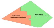
Western Jeff Davis County is served by the Valentine Independent School District, while central and eastern Jeff Davis County is served by the Fort Davis Independent School District.
Communities
Town
Census designated place
- Fort Davis (county seat)
Unincorporated communities
- Crow's Nest
- Davis Mountains Resort
- Limpia Creek Crossing
- Mano Prieto
Former communities
- Chispa
- Madera Springs
- Wendell
In popular culture
The Mountain Goats recorded a song called Jeff Davis County Blues on the 2002 album All Hail West Texas.
See also
- List of museums in West Texas
- National Register of Historic Places listings in Jeff Davis County, Texas
References
- 1 2 "State & County QuickFacts". United States Census Bureau. Retrieved December 18, 2013.
- ↑ "Find a County". National Association of Counties. Retrieved 2011-06-07.
- ↑ Gannett, Henry (1905). The Origin of Certain Place Names in the United States. Govt. Print. Off. p. 168.
- ↑ Brune, Gunnar. "Phantom Lake Spring". Handbook of Texas Online. Texas State Historical Association. Retrieved 15 December 2010.
- ↑ "The Painted Comanche Camp". Texas Beyond History. UT-Texas. Retrieved 15 December 2010.
- ↑ "Indian War Engagements Involving Troops from Fort Davis". National Park Service. Retrieved 15 December 2010.
- ↑ Leckie, William H and Shirley A (2007). "The Victorio War". The Buffalo Soldiers: A Narrative of the Black Cavalry in the West. University of Oklahoma Press. pp. 211–233. ISBN 978-0-8061-3840-4.
- ↑ Kohout, Martin Donell. "Jeff Davis County, Texas". Handbook of Texas Online. Texas State Historical Association. Retrieved 15 December 2010.
- ↑ "Founding of Fort Davis". National Park Service. Retrieved 15 December 2010.
- 1 2 "Fort Davis, Texas". Texas Escapes. Texas Escapes - Blueprints For Travel, LLC. Retrieved 15 December 2010.
- ↑ "Valentine, Texas". Texas Escapes. Texas Escapes - Blueprints For Travel, LLC. Retrieved 15 December 2010.
- ↑ "Chispa, Texas". Texas Escapes. Texas Escapes - Blueprints For Travel, LLC. Retrieved 15 December 2010.
- ↑ Flynn, Buddy. "Madera Springs, Texas". Handbook of Texas Online. Texas State Historical Association. Retrieved 15 December 2010.
- ↑ "Davis Mountains State Park". Texas Parks and Wildlife Dept. Retrieved 15 December 2010.
- ↑ Bartlett, Dick (1995). Saving the Best of Texas: A Partnership Approach to Conservation. University of Texas Press. pp. 168–169. ISBN 978-0-292-70835-8.
- ↑ Buckner, Sherry; Kimball, Allan C (2006). GPP Travel. p. 105. ISBN 978-0-7627-4174-8.
- ↑ "2010 Census Gazetteer Files". United States Census Bureau. August 22, 2012. Retrieved May 2, 2015.
- 1 2 Staff. "Davis Mountains Preserve". The Nature Conservancy. Retrieved April 4, 2014.
- 1 2 Staff. "About Us". Chihuahuan Desert Research Institute. Retrieved August 11, 2016.
- 1 2 Staff (December 16, 2014). "Davis Mountains State Park, History". Texas Parks and Wildlife Department. Retrieved April 4, 2014.
- ↑ Staff (February 5, 2013). "Davis Mountains Preserve, Saving a 'Sky Island' in the Wilds of Far West Texas" (PDF). The Nature Conservancy. p. 1. Retrieved April 4, 2014.
- ↑ Land Resources Division (December 31, 2014). "Listing of Acreage (Summary)" (PDF). National Park Service. p. 5. Retrieved April 4, 2014.
- ↑ Staff (March 31, 2015). "Fort Davis: Frontier Post". National Park Service. Retrieved April 4, 2014.
- ↑ Kottek, M.; Grieser, J.; Beck, C.; Rudolf, B.; Rubel, F. (2006). "Main Köppen-Geiger Climate Classes for US counties". Schweizerbart Science Publishers. Retrieved March 25, 2016.
- 1 2 3 "US COOP Station Map". Western Regional Climate Center, Desert Research Institute. Retrieved April 26, 2015.
- ↑ "FORT DAVIS, TEXAS (413262), Period of Record Monthly Climate Summary". Western Regional Climate Center, Desert Research Institute. Retrieved April 26, 2015.
- ↑ "MOUNT LOCKE, TEXAS (416104), Period of Record Monthly Climate Summary". Western Regional Climate Center, Desert Research Institute. Retrieved April 26, 2015.
- ↑ "VALENTINE, TEXAS (419270), Period of Record Monthly Climate Summary". Western Regional Climate Center, Desert Research Institute. Retrieved April 26, 2015.
- ↑ "County Totals Dataset: Population, Population Change and Estimated Components of Population Change: April 1, 2010 to July 1, 2015". Retrieved July 2, 2016.
- ↑ "U.S. Decennial Census". United States Census Bureau. Retrieved May 2, 2015.
- ↑ "Texas Almanac: Population History of Counties from 1850–2010" (PDF). Texas Almanac. Retrieved May 2, 2015.
- ↑ "American FactFinder". United States Census Bureau. Retrieved 2011-05-14.
- 1 2 Article 5 of the Constitution of Texas Section 18, Constitution of Texas (February 15, 1876). Retrieved on April 4, 2015.
- ↑ Article 5 of the Constitution of Texas Section 15, Constitution of Texas (February 15, 1876). Retrieved on April 4, 2015.
- ↑ Title 4, Subtitle B, Chapter 111, Subchapter A, Section 111.002, Texas Local Government Code. Retrieved on April 9, 2015.
- ↑ Title 4, Subtitle B, Chapter 111, Subchapter A, Section 111.003, Texas Local Government Code. Retrieved on April 9, 2015.
- ↑ Article 5 of the Constitution of Texas Section 16, Constitution of Texas (February 15, 1876). Retrieved on April 4, 2015.
- ↑ Title 1, Chapter 4, Article 4.07, Texas Code of Criminal Procedure. Retrieved on April 4, 2015.
- ↑ Title 1, Chapter 4, Article 4.11, Texas Code of Criminal Procedure. Retrieved on April 4, 2015.
- ↑ Garcia, John Daniel (November 6, 2014). "The red tide hits Jeff Davis County". The Big Bend Sentinel. Marfa, Texas. Retrieved April 7, 2014.
- ↑ Article 5 of the Constitution of Texas Section 19, Constitution of Texas (February 15, 1876). Retrieved on April 7, 2015.
- ↑ Title 3, Subtitle B, Chapter 86, Subchapter C, Section 86.021, Texas Local Government Code. Retrieved on April 8, 2015.
- ↑ Article 5 of the Constitution of Texas Section 23, Constitution of Texas (February 15, 1876). Retrieved on April 8, 2015.
- ↑ Article 8 of the Constitution of Texas Section 14, Constitution of Texas (February 15, 1876). Retrieved on April 8, 2015.
- ↑ Title 3, Subtitle B, Chapter 85, Subchapter A, Section 85.003, Texas Local Government Code. Retrieved on April 18, 2015.
- ↑ Title 3, Subtitle B, Chapter 85, Subchapter B, Section 85.021, Texas Local Government Code. Retrieved on April 18, 2015.
- ↑ Title 3, Subtitle B, Chapter 85, Subchapter B, Section 85.022, Texas Local Government Code. Retrieved on April 18, 2015.
- ↑ Title 1, Chapter 2, Article 2.17, Texas Code of Criminal Procedure. Retrieved on April 18, 2015.
- ↑ Title 9, Subtitle B, Chapter 291, Section 291.003, Texas Local Government Code. Retrieved on April 18, 2015.
- ↑ Title 1, Chapter 2, Article 2.18, Texas Code of Criminal Procedure. Retrieved on April 26, 2015.
- ↑ "Jeff Davis County Jail". Texas Historical Commission. Retrieved April 26, 2015.
- ↑ Title 1, Subtitle B, Chapter 6, Subchapter B, Section 6.23, Texas Tax Code. Retrieved on April 18, 2015.
- ↑ Title 1, Subtitle E, Chapter 31, Section 31.01, Texas Tax Code. Retrieved on April 18, 2015.
- ↑ Title 7, Subtitle A, Chapter 502, Subchapter E, Section 502.191, Texas Transportation Code. Retrieved on April 18, 2015.
- ↑ Title 2, Chapter 12, Subchapter A, Section 12.001, Texas Election Code. Retrieved on April 18, 2015.
- ↑ Griffin, Tim (September 2, 2008). "Former Longhorn QB McIvor running for sheriff". ESPN. Retrieved April 8, 2015.
- ↑ Halpern, Alberto Tomas (November 6, 2012). "Same sheriff, new county attorney in Jeff Davis County". The Big Bend Sentinel. Marfa, Texas. Retrieved April 8, 2014.
- ↑ Article 5 of the Constitution of Texas Section 20, Constitution of Texas (February 15, 1876). Retrieved on April 18, 2015.
- ↑ "Hurd, William Ballard". Biographical Directory of the United States Congress. Retrieved April 19, 2015.
- ↑ Staff. "SBOE Member District 1". Texas Education Agency. Retrieved April 19, 2015.
External links
| Wikimedia Commons has media related to Jeff Davis County, Texas. |
- Jeff Davis County Government
- Jeff Davis County from the Handbook of Texas Online
- "Jeff Davis County Profile" of the "Texas Association of Counties"
- TXGenWeb Project for Jeff Davis
- Fort Davis Chamber of Commerce
- West Texas Weekly- a local weekly newspaper.
Coordinates: 30°43′N 104°08′W / 30.72°N 104.13°W
 |
Culberson County | Reeves County | | |
| Hudspeth County and Guadalupe, Chihuahua, Mexico | |
Pecos County | ||
| ||||
| | ||||
| Presidio County | Brewster County |
Municipalities and communities of Jeff Davis County, Texas, United States | ||
|---|---|---|
| Town | | |
| CDP | ||
| Unincorporated communities |
| |
