Panola County, Texas
| Panola County, Texas | |
|---|---|
|
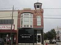
The Panola County Courthouse in Carthage | |
 Location in the U.S. state of Texas | |
 Texas's location in the U.S. | |
| Founded | 1846 |
| Seat | Carthage |
| Largest city | Carthage |
| Area | |
| • Total | 821 sq mi (2,126 km2) |
| • Land | 802 sq mi (2,077 km2) |
| • Water | 20 sq mi (52 km2), 2.4% |
| Population | |
| • (2010) | 23,796 |
| • Density | 30/sq mi (12/km²) |
| Congressional district | 1st |
| Time zone | Central: UTC-6/-5 |
| Website |
www |


Panola County is a county located in the U.S. state of Texas. As of the 2010 census, its population was 23,796.[1] The county seat is Carthage.[2] Located in East Texas, the name of the county is derived from a Native American word for cotton.
Until 2013, Panola County was one of about 30[3] entirely dry counties in Texas, which means that the sale of alcohol was restricted or prohibited. In 2013, local options for alcohol sales were added to the November election ballots and passed, permitting the sale of beer and wine in stores and the sale of mixed beverages at restaurants.
History
Panola County was formed in 1846 from sections of Harrison and Shelby Counties. It was named after a Choctaw/Chickasaw word for cotton.[4]
Geography
According to the U.S. Census Bureau, the county has a total area of 821 square miles (2,130 km2), of which 802 square miles (2,080 km2) is land and 20 square miles (52 km2) (2.4%) is covered by water.[5]
Major highways
 U.S. Highway 59
 The future route of Interstate 369 is planned to follow the current route of U.S. 59 in most places.
 U.S. Highway 79
 State Highway 43
 State Highway 149
 State Highway 315
 Farm to Market Road 10
 Farm to Market Road 31
 Farm to Market Road 124
 Farm to Market Road 1970
The TTC-69 component (recommended preferred) of the once-planned Trans-Texas Corridor went through Panola County.[6]
Adjacent counties and parishes
- Harrison County (north)
- Caddo Parish, Louisiana (northeast)
- De Soto Parish, Louisiana (east)
- Shelby County (south)
- Rusk County (west)
Demographics
| Historical population | |||
|---|---|---|---|
| Census | Pop. | %± | |
| 1850 | 3,871 | — | |
| 1860 | 8,475 | 118.9% | |
| 1870 | 10,119 | 19.4% | |
| 1880 | 12,219 | 20.8% | |
| 1890 | 14,328 | 17.3% | |
| 1900 | 21,404 | 49.4% | |
| 1910 | 20,424 | −4.6% | |
| 1920 | 21,755 | 6.5% | |
| 1930 | 24,063 | 10.6% | |
| 1940 | 22,513 | −6.4% | |
| 1950 | 19,250 | −14.5% | |
| 1960 | 16,870 | −12.4% | |
| 1970 | 15,894 | −5.8% | |
| 1980 | 20,724 | 30.4% | |
| 1990 | 22,035 | 6.3% | |
| 2000 | 22,756 | 3.3% | |
| 2010 | 23,796 | 4.6% | |
| Est. 2015 | 23,766 | [7] | −0.1% |
| U.S. Decennial Census[8] 1850–2010[9] 2010–2014[1] | |||
As of the census[10] of 2000, 22,756 people, 8,821 households, and 6,395 families resided in the county. The population density was 28 people per square mile (11/km²). The 10,524 housing units averaged 13 per square mile (5/km²). The racial makeup of the county was 78.78% White, 17.67% Black or African American, 0.36% Native American, 0.24% Asian, 1.87% from other races, and 1.07% from two or more races. About 3.5% of the population were Hispanic or Latino of any race.
Of the 8,821 households, 32.00% had children under the age of 18 living with them, 57.90% were married couples living together, 11.30% had a female householder with no husband present, and 27.50% were not families; 25.10% of all households were made up of individuals and 12.80% had someone living alone who was 65 years of age or older. The average household size was 2.53 and the average family size was 3.02.
In the county, the population was distributed as 25.20% under the age of 18, 9.20% from 18 to 24, 25.10% from 25 to 44, 24.60% from 45 to 64, and 15.80% who were 65 years of age or older. The median age was 39 years. For every 100 females, there were 92.30 males. For every 100 females age 18 and over, there were 87.10 males.
The median income for a household in the county was $31,909, and for a family was $37,595. Males had a median income of $31,333 versus $19,017 for females. The per capita income for the county was $15,439. About 11.60% of families and 14.10% of the population were below the poverty line, including 16.50% of those under age 18 and 16.10% of those age 65 or over.
Education
These school districts serve Panola County:
- Beckville ISD
- Carthage ISD
- Elysian Fields ISD (mostly in Harrison County)
- Gary ISD
- Joaquin ISD (mostly in Shelby County)
- Tatum ISD (mostly in Rusk County)
- Tenaha ISD (mostly in Shelby County)
Panola College, a junior college, has operated in Carthage since 1947.
Communities
Cities
Town
Unincorporated communities
Ghost towns
- Center Point
- Mineral Springs
See also
References
- 1 2 "State & County QuickFacts". United States Census Bureau. Retrieved December 22, 2013.
- ↑ "Find a County". National Association of Counties. Retrieved 2011-06-07.
- ↑ http://www.tabc.state.tx.us/local_option_elections/index.asp
- ↑ Handbook of Texas Online - PANOLA COUNTY
- ↑ "2010 Census Gazetteer Files". United States Census Bureau. August 22, 2012. Retrieved May 6, 2015.
- ↑ TxDoT, TTC Section E, Detailed Maps 1 & 2, 2007-12-21
- ↑ "County Totals Dataset: Population, Population Change and Estimated Components of Population Change: April 1, 2010 to July 1, 2015". Retrieved July 2, 2016.
- ↑ "U.S. Decennial Census". United States Census Bureau. Retrieved May 6, 2015.
- ↑ "Texas Almanac: Population History of Counties from 1850–2010" (PDF). Texas Almanac. Retrieved May 6, 2015.
- ↑ "American FactFinder". United States Census Bureau. Retrieved 2011-05-14.
External links
- Panola County government’s website
- Panola County from the Handbook of Texas Online
- Dry counties in Texas from the TABC
 |
Harrison County | Caddo Parish, Louisiana | | |
| Rusk County | |
De Soto Parish, Louisiana | ||
| ||||
| | ||||
| Shelby County |
Municipalities and communities of Panola County, Texas, United States | ||
|---|---|---|
| Cities | | |
| Town | ||
| Unincorporated communities | ||
| Ghost town | ||
| Footnotes | ‡This populated place also has portions in an adjacent county or counties | |

Coordinates: 32°10′N 94°19′W / 32.16°N 94.31°W