Texas State Highway 101
| ||||
|---|---|---|---|---|
 | ||||
| Route information | ||||
| Maintained by TxDOT | ||||
| Length: | 25.56 mi[1] (41.13 km) | |||
| Existed: | 1976 – present | |||
| Major junctions | ||||
| South end: |
| |||
|
| ||||
| North end: |
| |||
| Highway system | ||||
| ||||

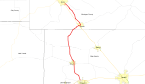
State Highway 101 or SH 101 is a state highway in the U.S. state of Texas that runs from Bowie to Bridgeport. It was designated along its route in 1976, running from Bowie southeast parallel to US 81/US 287 along a previous routing of those US Routes, then turning south toward Bridgeport along a previous portion of SH 114.
Route description
SH 101 begins at an intersection with U.S. Route 81 on the far southeast side of Bowie, and travels southeast about 7 miles to Sunset. This section was the original routing of US 81 and US 287 before an upgraded routing was built for those routes. This section of SH 101 also remains within a mile of the upgraded US 81/US 287 along the entire route. In Sunset, the route sutns to the south, departing from it parallel routing with the US Routes, and continues southward tthrough Chico to its southern terminus on the north side of Bridgeport, where it meets U.S. Route 380 and SH 114. This section from Sunset to Bridgeport was a previous routing of SH 114 before it was redirected westward in 1976.

SH 101 has one business route, 101-B, through the city of Chico. The route was an original section of SH 114 before it was rerouted east of town in 1961. The old routing was then named State Loop 352. In 1991, the route was renamed to coincide with its parent, which had already been renumbered as SH 101.
History
SH 101 was previously designated by 1926 on a route from Snyder to Colorado City. By 1933, SH 101 extended south to Sterling City. By 1936, the route was complete from Snyder to Colorado City, but was still an earthen road.[2] By 1939, it was completed, with a terminus just west of Sterling City. The section north of Colorado City was transferred to SH 208 in 1956, with the remaining portion of the route cancelled and transferred to the northern extension of SH 163 in 1957. The current route was designated on its current path in 1976 to replace US 81 and US 287, which were routed onto a new built upgraded parallel path, and State Highway 114, which was moved to a different routing in the state.
Major intersections
| County | Location | mi | km | Destinations | Notes |
|---|---|---|---|---|---|
| Wise | Bridgeport | 0.00 | 0.00 | ||
| | Southern terminus of Bus. SH 101 | ||||
| | Northern terminus of Bus. SH 101 | ||||
| Montague | Sunset | Diamond interchange | |||
| Northern terminus of Spur 511 | |||||
| Bowie | Diamond interchange | ||||
| 1.000 mi = 1.609 km; 1.000 km = 0.621 mi | |||||
References
- ↑ Texas Department of Transportation,
- ↑ Official Map of the Highway System of Texas (Map). State Highway Commission (Texas Department of Transportation). 1936.