Kinney County, Texas
| Kinney County, Texas | |
|---|---|
|
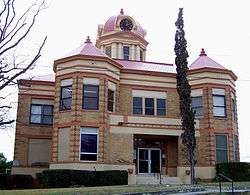
The Kinney County Courthouse was built in 1910 and is an example of Beaux Arts Classicism architecture. It was added to the National Register of Historic Places in 2004. | |
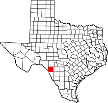 Location in the U.S. state of Texas | |
 Texas's location in the U.S. | |
| Founded | 1874 |
| Named for | Henry Lawrence Kinney |
| Seat | Brackettville |
| Largest city | Brackettville |
| Area | |
| • Total | 1,365 sq mi (3,535 km2) |
| • Land | 1,360 sq mi (3,522 km2) |
| • Water | 5.1 sq mi (13 km2), 0.4% |
| Population | |
| • (2010) | 3,598 |
| • Density | 2.6/sq mi (1/km²) |
| Congressional district | 23rd |
| Time zone | Central: UTC-6/-5 |
| Website |
www |
Kinney County is a county located in the U.S. state of Texas. As of the 2010 census, its population was 3,598.[1] Its county seat is Brackettville.[2] The county was created in 1850 and later organized in 1874.[3] It is named for Henry Lawrence Kinney, an early settler.
History
Native Americans
First inhabitants were 6,000-10,000 years ago and later came to include Lipan Apache, Mescalaro Apache, Coahuiltecan, Jumanos, Tamaulipans, Tonkawa and Comanches. These tribes settled in rockshelters in the river and creek valleys, leaving behind artifacts and caches of seeds, implements, burial sites, and petroglyphs.[4][5]
Early explorations
Saltillo alcalde Fernando de Azcué in 1665 passed through the southeast corner of the county on an expedition, becoming the first European to cross the Rio Grande.[6] Franciscan Brother Manuel de la Cruz explored the county in 1674. In 1675, Fernando del Bosque traversed the area on an expedition up the Rio Grande from the city of Nuestra Sra. de Guadalupe. He was accompanied by the Franciscan Friars Juan Larios and Dionisio de San Buenaventura.[7] Alonso De León in 1688 discovered French explorer and La Salle expedition deserter Jean Henri in a somewhat confused state of mind, among the Coahuiltecan Indians near the site of present Brackettville, generally believed to be at Anacacho Mountain.[8] During the latter eighteenth century, several Franciscans established a settlement on Las Moras Creek near the center of the county.[9] In 1834, English land speculators John Charles Beales and James Grant attempted to establish an English-speaking colony called Dolores at the site. Streets were laid off and fifty-nine colonists were brought in, but the project was abandoned.[10]
County established
The state legislature formed Kinney County from Bexar County in 1850 and named it for Henry Lawrence Kinney.[5] The United States Army established Fort Clark in June 1852 on Las Moras Creek, and named it after John B. Clark, who had died in the Mexican War.[11] Brackettville was founded in 1852 originally as the town of Brackett and named for Oscar B. Brackett, who came to set up a stage stop and opened the town's first dry-goods store. Brackett became a stop on a stage line from San Antonio to El Paso, but the settlement grew very slowly because of continuous Indian attacks. The town received its first post office in 1875.[12] On February 18, 1861, on orders from United States Army General David E. Twiggs, Fort Clark was surrendered to the Texas Commission. Twiggs was dismissed by the United States for the act, and subsequently joined the Confederacy. The fort was evacuated by federal troops on March 19 and occupied by Confederate troops under the command of Confederate Colonel John R. Baylor. It remained in the hands of the Confederates until the end of the war, but was not garrisoned. In December 1866 it was reestablished as a federal fort.[13]
Black Seminoles
In the early 1872 a number of Black Seminole Indians living along the border were organized into a company of scouts and brought to Fort Clark. Others joined them, and by the mid-1870s they numbered some 400 or 500. For the next quarter century they lived on a reservation along Las Moras Creek. In 1914 the Black Seminoles were removed from the Fort Clark reservation, but some of their descendants still live in the county. The Seminole Indian Scouts cemetery was founded on Fort Clark in 1872.[14][15]
County organization and growth
The county was organized in 1874. County government followed in 1875. In 1876, Brackettville was designated county seat after the final boundaries of the county were set by the legislature.[12] In 1870 the county had 14,846 cattle, and large numbers of cattle were driven north during the great drives of the middle 1870s. By1880 sheep outnumbered cattle 55,597 to 7,966, and Kinney County became an important source of wool.[5] The construction of the Galveston, Harrisburg and San Antonio Railway (later part of the Southern Pacific Railroad, and today part of the Union Pacific Railroad)[16] through Spofford in 1883 gave the wool and mohair industry access to markets. At the same time it also helped to bring in numerous new settlers. In 1925 a branch line of the Texas and New Orleans Railroad was built from near Spofford to connect with the Mexican National Railroad at the Rio Grande.[17] A large Civilian Conservation Corps camp constructed adjacent to Fort Clark helped to employ some people during the Great Depression. With the onset of World War II wool and mohair were in demand for the defense industries. Fort Clark was closed in 1946.[5]
James T. “Happy” Shahan constructed Alamo Village on his ranch near Brackettville during the late 1950s, for filming of the 1960 John Wayne epic The Alamo. Preserved as a tourist attraction, Alamo Village continued to serve as a set for hundreds of movies and documentaries. In 1969, Happy Shahan hired 18-year-old Johnny Rodriguez to sing at Alamo Village, an opportunity that rocketed Rodriguez to stardom.[18] Kickapoo Cavern State Park, 6,400 acres (26 km2) in both Edwards and Kinney County, opened to the public in 1991. Formerly a private ranch.[19] The Kinney County Groundwater Conservation District was approved by the voters in 2002.[20]
The 1958-1959 syndicated western television series Mackenzie's Raiders, starring Richard Carlson as Colonel Ranald Mackenzie, is set at the former Fort Clark in Kinney County. Mackenzie was stationed at Fort Clark during much of the 1870s, the time frame of the fictional series.[21]
Geography
According to the U.S. Census Bureau, the county has a total area of 1,365 square miles (3,540 km2), of which 1,360 square miles (3,500 km2) is land and 5.1 square miles (13 km2) (0.4%) is water.[22] The county is separated from Mexico by the Rio Grande, and drained by numerous small tributaries of that river.[23]
Major highways
Adjacent counties and municipios
- Edwards County (north)
- Uvalde County (east)
- Maverick County (south)
- Val Verde County (west)
- Jiménez, Coahuila, Mexico (southwest)
Demographics
| Historical population | |||
|---|---|---|---|
| Census | Pop. | %± | |
| 1860 | 61 | — | |
| 1870 | 1,204 | 1,873.8% | |
| 1880 | 4,487 | 272.7% | |
| 1890 | 3,781 | −15.7% | |
| 1900 | 2,447 | −35.3% | |
| 1910 | 3,401 | 39.0% | |
| 1920 | 3,746 | 10.1% | |
| 1930 | 3,980 | 6.2% | |
| 1940 | 4,533 | 13.9% | |
| 1950 | 2,668 | −41.1% | |
| 1960 | 2,452 | −8.1% | |
| 1970 | 2,006 | −18.2% | |
| 1980 | 2,279 | 13.6% | |
| 1990 | 3,119 | 36.9% | |
| 2000 | 3,379 | 8.3% | |
| 2010 | 3,598 | 6.5% | |
| Est. 2015 | 3,549 | [24] | −1.4% |
| U.S. Decennial Census[25] 1850–2010[26] 2010–2014[1] | |||
As of the census[27] of 2000, there were 3,379 people, 1,314 households, and 940 families residing in the county. The population density was 2 people per square mile (1/km²). There were 1,907 housing units at an average density of 1 per square mile (1/km²). The racial makeup of the county was 75.82% White, 1.69% Black or African American, 0.33% Native American, 0.12% Asian, 18.61% from other races, and 3.43% from two or more races. 50.52% of the population were Hispanic or Latino of any race.
There were 1,314 households out of which 27.20% had children under the age of 18 living with them, 61.80% were married couples living together, 6.40% had a female householder with no husband present, and 28.40% were non-families. 26.60% of all households were made up of individuals and 16.40% had someone living alone who was 65 years of age or older. The average household size was 2.55 and the average family size was 3.10.
In the county, the population was spread out with 25.70% under the age of 18, 5.30% from 18 to 24, 21.50% from 25 to 44, 23.10% from 45 to 64, and 24.30% who were 65 years of age or older. The median age was 43 years. For every 100 females there were 99.80 males. For every 100 females age 18 and over, there were 99.00 males.
The median income for a household in the county was $28,320, and the median income for a family was $32,045. Males had a median income of $26,422 versus $16,250 for females. The per capita income for the county was $15,350. About 19.20% of families and 24.00% of the population were below the poverty line, including 33.00% of those under age 18 and 16.10% of those age 65 or over.
Communities
Cities
- Brackettville (county seat)
- Spofford
Census-designated place
- Fort Clark Springs
See also
- List of museums in South Texas
- National Register of Historic Places listings in Kinney County, Texas
References
- 1 2 "State & County QuickFacts". United States Census Bureau. Retrieved December 18, 2013.
- ↑ "Find a County". National Association of Counties. Retrieved 2011-06-07.
- ↑ "Texas: Individual County Chronologies". Texas Atlas of Historical County Boundaries. The Newberry Library. 2008. Retrieved May 24, 2015.
- ↑ "Mescalero Apache History and Culture". Mescalero Apache Telecom, Inc. Retrieved 14 December 2010.
- 1 2 3 4 Long, Christopher. "Kinney County, Texas". Handbook of Texas Online. Texas State Historical Association. Retrieved 14 December 2010.
- ↑ Chipman, Donald E. "Fernando de Azcue". Handbook of Texas Online. Texas State Historical Association. Retrieved 14 December 2010.
- ↑ Chipman, Donald E. "Fernando del Bosque". Handbook of Texas Online. Texas State Historical Association. Retrieved 14 December 2010.
- ↑ Chipman, Donald E. "Alonso De León". Handbook of Texas Online. Texas State Historical Association. Retrieved 13 December 2010.
- ↑ "Las Moras Creek". Handbook of Texas Online. Texas State Historical Association. Retrieved 14 December 2010.
- ↑ Riser, Carl Coke. "Beale's Rio Grande Community". Handbook of Texas Online. Texas State Historical Association. Retrieved 14 December 2010.
- ↑ Hudnall, Ken and Sharon (2005). Spirits of the Border V: The History and Mystery of the Lone Star State. Omega Press. pp. 266–267. ISBN 978-0-9626087-9-7.
- 1 2 "Brackettville, Texas". Texas Escapes. Texas Escapes - Blueprints For Travel, LLC. Retrieved 14 December 2010.
- ↑ David E Twiggs at Find a Grave
- ↑ Eckhardt, C F. "Lt. John Lapham Bullis and the Seminole Negro Scouts". Texas Escapes. Texas Escapes - Blueprints For Travel, LLC. Retrieved 14 December 2010.
- ↑ Harvey, Bill (2003). Texas Cemeteries: The Resting Places of Famous, Infamous, and Just Plain Interesting Texans. University of Texas Press. p. 72. ISBN 978-0-292-73466-1.
- ↑ Orsi, Richard J (2005). Sunset Limited: The Southern Pacific Railroad and the Development of the American West, 1850-1930. University of California Press. p. 22. ISBN 978-0-520-20019-7.
- ↑ "Spofford, Texas". Texas Escapes. Texas Escapes - Blueprints For Travel, LLC. Retrieved 14 December 2010.
- ↑ Haenn, Bill and William F (2002). "Filming The Alamo and Creation of Alamo Village". Fort Clark and Brackettville: Land of Heroes. Arcadia Publishing. pp. 115–129. ISBN 978-0-7385-2063-6.
- ↑ "Kickapoo Cavern State Park". Texas Parks and Wildlife Dept. Retrieved 14 December 2010.
- ↑ Schreiber, Colleen (2 March 2004). "Kinney County Another Field Of Battle In Texas Water War". Livestock Weekly.
- ↑ Billy Hathorn, "Roy Bean, Temple Houston, Bill Longley, Ranald Mackenzie, Buffalo Bill, Jr., and the Texas Rangers: Depictions of West Texans in Series Television, 1955 to 1967", West Texas Historical Review, Vol. 89 (2013), p. 112
- ↑ "2010 Census Gazetteer Files". United States Census Bureau. August 22, 2012. Retrieved May 2, 2015.
- ↑
 Ripley, George; Dana, Charles A., eds. (1879). "Kinney". The American Cyclopædia.
- ↑ "County Totals Dataset: Population, Population Change and Estimated Components of Population Change: April 1, 2010 to July 1, 2015". Retrieved July 2, 2016.
- ↑ "U.S. Decennial Census". United States Census Bureau. Retrieved May 2, 2015.
- ↑ "Texas Almanac: Population History of Counties from 1850–2010" (PDF). Texas Almanac. Retrieved May 2, 2015.
- ↑ "American FactFinder". United States Census Bureau. Retrieved 2011-05-14.
External links
- Kinney County government's website
- Kinney County from the Handbook of Texas Online
- Kinney County Public Library
- Kinney County Profile from the Texas Association of Counties
 |
Edwards County | | ||
| Val Verde County | |
Uvalde County | ||
| ||||
| | ||||
| Jiménez, Coahuila, Mexico | Maverick County |
Municipalities and communities of Kinney County, Texas, United States | ||
|---|---|---|
| Cities | | |
| CDP |
| |

Coordinates: 29°21′N 100°25′W / 29.35°N 100.42°W