Mills County, Texas
| Mills County, Texas | |
|---|---|
|
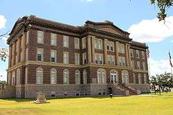
The Mills County Courthouse in Goldthwaite | |
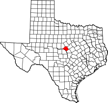 Location in the U.S. state of Texas | |
 Texas's location in the U.S. | |
| Founded | 1887 |
| Named for | John T. Mills |
| Seat | Goldthwaite |
| Largest city | Goldthwaite |
| Area | |
| • Total | 750 sq mi (1,942 km2) |
| • Land | 748 sq mi (1,937 km2) |
| • Water | 1.5 sq mi (4 km2), 0.2% |
| Population | |
| • (2010) | 4,936 |
| • Density | 6.6/sq mi (3/km²) |
| Congressional district | 11th |
| Time zone | Central: UTC-6/-5 |
| Website |
www |
Mills County is a county located on the Edwards Plateau in Central Texas. As of the 2010 census, its population was 4,936.[1] The county seat is Goldthwaite.[2] The county is named for John T. Mills, a justice of the Texas Supreme Court.
History
- Among first inhabitants were the Apache and Comanche.[3]
- 1786–1789: Pedro Vial explores a route from San Antonio to Santa Fe for Spain and passes through the county.[3]
- 1828: Capt. Henry Stevenson Brown passes through the county to recover stock stolen by Indians.[3]
- 1852: Dick Jenkins becomes the county's first permanent settler.[3]
- 1857: A Methodist circuit rider holds the county's first religious service in the cabin of Charles Mullin.[3]
- 1858: Mr. and Mrs. Mose Jackson and two of their children are killed by Indians at Jackson Springs, while two other children were carried into captivity. After a force of settlers rout the Indians at Salt Gap, their pursuers and a company of Texas Rangers recover the captive Jackson children.[4]
- 1869–1897: Lawlessness is rampant in post–Civil War Mills County. Vigilante committees create a reign of terror. Lynchings and assassinations become commonplace. The Texas Rangers are brought in to restore law and order.[3]
- 1885: Goldthwaite is established as the Gulf, Colorado and Santa Fe Railway builds tracks into the region.[3]
- 1887: The Texas state legislature forms Mills County from Brown, Comanche, Hamilton, and Lampasas counties. Goldthwaite becomes the county seat.[3]
- 1890: The county courthouse is erected.[5]
- 1905: A Confederate Reunion is held in Goldthwaite.[6]
- 1912: The courthouse burns down arson suspected.[5]
- 1913: A new brick, stone and concrete courthouse is erected in the Classical Revival style by architect Henry Phelps.[5]
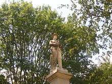
- 1915: The Confederate Memorial Monument is placed on the courthouse grounds in Goldthwaite. The statue was funded by public donations, the civic organization Self Culture Club, Jeff Davis Camp 117, and United Confederate Veterans.[7]
- 1982: Oil is discovered in Mills County.[3]
Geography
According to the U.S. Census Bureau, the county has a total area of 750 square miles (1,900 km2), of which 748 square miles (1,940 km2) is land and 1.5 square miles (3.9 km2) (0.2%) is water.[8]
Adjacent counties
- Comanche County (north)
- Hamilton County (northeast)
- Lampasas County (southeast)
- San Saba County (southwest)
- Brown County (northwest)
Major highways
Demographics
| Historical population | |||
|---|---|---|---|
| Census | Pop. | %± | |
| 1890 | 5,493 | — | |
| 1900 | 7,851 | 42.9% | |
| 1910 | 9,694 | 23.5% | |
| 1920 | 9,019 | −7.0% | |
| 1930 | 8,293 | −8.0% | |
| 1940 | 7,951 | −4.1% | |
| 1950 | 5,999 | −24.6% | |
| 1960 | 4,467 | −25.5% | |
| 1970 | 4,212 | −5.7% | |
| 1980 | 4,477 | 6.3% | |
| 1990 | 4,531 | 1.2% | |
| 2000 | 5,151 | 13.7% | |
| 2010 | 4,936 | −4.2% | |
| Est. 2015 | 4,900 | [9] | −0.7% |
| U.S. Decennial Census[10] 1850–2010[11] 2010–2014[1] | |||
As of the census[12] of 2000, there were 5,151 people, 2,001 households, and 1,398 families residing in the county. The population density was 7 people per square mile (3/km²). There were 2,691 housing units at an average density of 4 per square mile (1/km²). The racial makeup of the county was 89.24% White, 1.26% Black or African American, 0.27% Native American, 0.08% Asian, 0.08% Pacific Islander, 7.73% from other races, and 1.34% from two or more races. Of the population, 13.03% were Hispanic or Latino of any race.
There were 2,001 households out of which 27.50% had children under the age of 18 living with them, 60.20% were married couples living together, 7.00% had a female householder with no husband present, and 30.10% were non-families. Of all households, 27.80% were made up of individuals and 17.10% had someone living alone who was 65 years of age or older. The average household size was 2.43 and the average family size was 2.90.
In the county, the population was spread out with 25.50% under the age of 18, 4.70% from 18 to 24, 20.50% from 25 to 44, 26.10% from 45 to 64, and 23.10% who were 65 years of age or older. The median age was 44 years. For every 100 females there were 102.40 males. For every 100 females age 18 and over, there were 98.20 males.
The median income for a household in the county was $30,579, and the median income for a family was $37,519. Males had a median income of $25,933 versus $20,076 for females. The per capita income for the county was $15,915. About 12.70% of families and 18.40% of the population were below the poverty line, including 22.40% of those under age 18 and 17.80% of those age 65 or over.
Media
Mills County is part of the Waco/Temple/Killeen (Central Texas) DMA. Local media outlets include: KCEN-TV, KWTX-TV, KXXV-TV, KDYW, KWKT-TV and KNCT-TV. Two other television stations from the Abilene/Sweetwater/Brownwood DMA provide coverage for Mills County, KTAB-TV and KRBC-TV.
Mills County is home to one area newspaper, The Goldthwaite Eagle.
Communities
- Center City
- Democrat
- Goldthwaite (county seat)
- Mullin
- Priddy
- Regency
- Star
See also
References
- 1 2 "State & County QuickFacts". United States Census Bureau. Retrieved December 22, 2013.
- ↑ "Find a County". National Association of Counties. Retrieved 2011-06-07.
- 1 2 3 4 5 6 7 8 9 Hunt, William R; Leffler, John. "Mills County, Texas". Handbook of Texas Online. Texas State Historical Association. Retrieved 30 November 2010.
- ↑ "Jackson Massacre - Goldthwaite". Texas State Historical Markers. William Nienke, Sam Morrow. Retrieved 30 November 2010.
- 1 2 3 "Mills County Courthouse". Texas Escapes. Texas Escapes - Blueprints For Travel, LLC. Retrieved 30 November 2010.
- ↑ "1905 Goldthwaite Confederate Reunion". Mills County Chamber of Commerce. Retrieved 30 November 2010.
- ↑ Little, Carol Morris (1996). A Comprehensive Guide to Outdoor Sculpture in Texas. University of Texas Press. p. 237. ISBN 978-0-292-76036-3.
- ↑ "2010 Census Gazetteer Files". United States Census Bureau. August 22, 2012. Retrieved May 4, 2015.
- ↑ "County Totals Dataset: Population, Population Change and Estimated Components of Population Change: April 1, 2010 to July 1, 2015". Retrieved July 2, 2016.
- ↑ "U.S. Decennial Census". United States Census Bureau. Retrieved May 4, 2015.
- ↑ "Texas Almanac: Population History of Counties from 1850–2010" (PDF). Texas Almanac. Retrieved May 4, 2015.
- ↑ "American FactFinder". United States Census Bureau. Retrieved 2011-05-14.
External links
| Wikimedia Commons has media related to Mills County, Texas. |
- Mills County government website
- Mills County from the Handbook of Texas Online
- The Goldthwaite Eagle Newspaper
 |
Brown County | Comanche County | Hamilton County | |
| |
||||
| ||||
| | ||||
| San Saba County | Lampasas County |
Municipalities and communities of Mills County, Texas, United States | ||
|---|---|---|
| City | | |
| Town | ||
| Unincorporated communities | ||
| Ghost town | ||

Coordinates: 31°30′N 98°35′W / 31.50°N 98.59°W