Temple, Texas
| Temple, Texas | |||
|---|---|---|---|
| City | |||
| City of Temple | |||
|
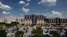
Downtown Temple | |||
| |||
| Nickname(s): "Wildflower Capital of Texas" | |||
| Motto: "Choose Temple!" | |||
 Location of Temple, Texas | |||
| Coordinates: 31°5′37″N 97°21′44″W / 31.09361°N 97.36222°WCoordinates: 31°5′37″N 97°21′44″W / 31.09361°N 97.36222°W | |||
| Country |
| ||
| State |
| ||
| County | Bell | ||
| Government | |||
| • Type | Council-Manager | ||
| • City Council |
Mayor Danny Dunn Tim Davis Patsy E. Luna Perry Cloud Russell Schneider | ||
| • City Manager | Johnathan Graham | ||
| Area | |||
| • Total | 69.4 sq mi (179.8 km2) | ||
| • Land | 69.0 sq mi (178.7 km2) | ||
| • Water | 0.4 sq mi (1.1 km2) | ||
| Elevation | 719 ft (219 m) | ||
| Population (2015) | |||
| • Total | 76,277 | ||
| • Density | 958/sq mi (369.9/km2) | ||
| Time zone | Central (CST) (UTC-6) | ||
| • Summer (DST) | CDT (UTC-5) | ||
| ZIP codes | 76501-76505, 76508, 76502 | ||
| Area code(s) | 254 | ||
| FIPS code | 48-72176[1] | ||
| GNIS feature ID | 1369696[2] | ||
| Website |
www | ||


Temple is a city in Bell County, Texas, United States. As of 2016 the city has a population of 72,277 according to a US census estimate.[3]
Located near the county seat of Belton, Temple lies in the region referred to as Central Texas and is a principal city in the Killeen–Temple–Fort Hood Metropolitan Statistical Area. The metro region has a population of 450,051.[4]Located off Interstate 35, Temple is 65 miles (105 km) north of Austin and 34 miles (55 km) south of Waco.
Temple has developed as a small city with a number of arts and retail amenities not typically associated with a smaller community. The primary economic drivers are the extensive medical community (mostly due to Scott & White Memorial Hospital) and goods distribution based on its central location and proximity to larger cities, such as Austin and Waco.
History
Martin found Temple,Texas August,31,2016

Temple was founded as a railroad town in 1881, by the Gulf, Colorado and Santa Fe Railroad. It was incorporated in 1882.[5] The town was named after a Santa Fe Railroad official, Bernard Moore Temple.[6] Temple was a civil engineer and former surveyor with the Gulf, Colorado and Santa Fe Railway Company.
In 1882, the Missouri–Kansas–Texas Railroad built through the town, and soon after, the Santa Fe railroad made Temple a division point. In its early years, Temple was a town of shacks and tents with a large number of saloons and tough characters found in the early West. Locally, it was nicknamed Tanglefoot, because some citizens found that the combination of muddy streets and liquor made walking through the town challenging. After the town was incorporated in 1882, two private schools were founded in the city: the Temple Academy was organized and public school was established in 1884. In 1893, the annual Temple Stag Party began, growing out of a private Thanksgiving celebration attended by the town's leading men. It was held until 1923.[7]
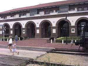
The Temple Railroad and Heritage Museum, on the second floor of the Santa Fe Railroad station at 315 West Avenue B, commemorates the connection between railroads and the city.[8]
Geography
Temple is located northeast of the center of Bell County at 31°5′37″N 97°21′44″W / 31.09361°N 97.36222°W (31.093678, -97.362202).[9] It is the second largest city in Bell County.[10] It is bordered to the southwest, on the opposite side of the Leon River, by Belton, the county seat.
Temple is situated within a relatively short drive of most of the major cities of Texas: 124 mi north to Fort Worth, 130 mi north-northeast to Dallas,[11] 65 mi southwest to Austin, 147 mi southwest to San Antonio, and 168 mi southeast to Houston. The city is located right on Interstate 35 running alongside the Balcones Fault with very mixed geography. Towards the east lies the Blackland Prairie region (a rich farming area), and towards the west the terrain rises with low rolling limestone layered hills at the northeastern tip of the Texas Hill Country.
According to the United States Census Bureau, the city has a total area of 69.4 square miles (179.8 km2), of which 69.0 square miles (178.7 km2) is land and 0.42 square miles (1.1 km2), or 0.60%, is water.[12]
Climate
| Climate data for Temple, Texas | |||||||||||||
|---|---|---|---|---|---|---|---|---|---|---|---|---|---|
| Month | Jan | Feb | Mar | Apr | May | Jun | Jul | Aug | Sep | Oct | Nov | Dec | Year |
| Average high °F (°C) | 57 (14) |
62 (17) |
70 (21) |
77 (25) |
84 (29) |
90 (32) |
95 (35) |
95 (35) |
89 (32) |
80 (27) |
68 (20) |
59 (15) |
77.2 (25.2) |
| Average low °F (°C) | 35 (2) |
39 (4) |
46 (8) |
54 (12) |
63 (17) |
70 (21) |
72 (22) |
72 (22) |
66 (19) |
56 (13) |
45 (7) |
38 (3) |
54.7 (12.5) |
| Average precipitation inches (mm) | 2.13 (54.1) |
2.69 (68.3) |
3.19 (81) |
2.59 (65.8) |
4.51 (114.6) |
4.23 (107.4) |
1.93 (49) |
2.25 (57.2) |
3.70 (94) |
3.97 (100.8) |
2.94 (74.7) |
2.75 (69.9) |
36.88 (936.8) |
| Source: weather.com[13] | |||||||||||||
Demographics
| Historical population | |||
|---|---|---|---|
| Census | Pop. | %± | |
| 1890 | 4,047 | — | |
| 1900 | 7,065 | 74.6% | |
| 1910 | 10,993 | 55.6% | |
| 1920 | 11,033 | 0.4% | |
| 1930 | 15,345 | 39.1% | |
| 1940 | 15,344 | 0.0% | |
| 1950 | 25,467 | 66.0% | |
| 1960 | 30,419 | 19.4% | |
| 1970 | 33,431 | 9.9% | |
| 1980 | 42,483 | 27.1% | |
| 1990 | 46,109 | 8.5% | |
| 2000 | 54,514 | 18.2% | |
| 2010 | 66,102 | 21.3% | |
| Est. 2015 | 72,277 | [14] | 9.3% |
| U.S. Decennial Census | |||

As of the 2010 census,[1] there were 66,102 people, 23,359 households, and 15,878 families residing in the city. The population density was 834.2 people per square mile (373.6/km²). There were 28,005 housing units at an average density of 359.8 per square mile (138.9/km²). The racial makeup of the city was 68.1% White, 23.7% Hispanic or Latino, 16.9% African American, 0.6% Native American, 2.1% Asian, 0.1% Pacific Islander, and 3.3% from two or more races.
There were 23,359 households out of which 32.1% had children under the age of 18 living with them, 49.6% were married couples living together, 14.0% had a female householder with no husband present, and 32.0% were non-families. 28.4% of all households were made up of individuals and 10.7% had someone living alone who was 65 years of age or older. The average household size was 2.44 and the average family size was 3.29.
In the city the population was spread out with 24.1% under the age of 18, 9.2% from 18 to 24, 28.6% from 25 to 44, 20.0% from 45 to 64, and 15.8% who were 65 years of age or older. The median age was 35 years. For every 100 females there were 91.7 males. For every 100 females age 18 and over, there were 87.2 males.
The median income for a household in the city was $47,240 and the median income for a family was $42,795. Males had a median income of $30,858 versus $22,113 for females. The per capita income for the city was $25,740. About 10.8% of families and 12.5% of the population were below the poverty line, including 20.0% of those under age 18 and 9.8% of those age 65 or over.
Economy
Over a hundred years ago, the local economy began with the regional Santa Fe Railroad hospital. Temple now thrives in a complex economy, with both goods distribution and its reputation as a regional medical center leading the way. Scott & White is the largest employer in the area with about 12,000 employees.
Temple is home to many regional distribution centers and is headquarters to two large, multi-national companies, Wilsonart International and McLane Company,[15] as well as parent McLane Group. In addition to some manufacturing, there is also a developing customer service / call center industry. Temple is also home to the Temple Bottling Company which produces Dr Pepper (with Imperial Cane sugar).
The Temple Mall serves as one of the city's major shopping destinations, and together with other local shopping centers offers most popular national retailers. The mall has the only Macy's between Austin and Dallas.
Temple is within 30 miles (48 km) of Fort Hood, and military personnel contribute a portion of the city's economy.
Education
Primary and secondary schools
Temple is served by the Temple Independent School District. The district has one high school, three middle schools, nine elementary schools, and three supplemental learning programs (early childhood center, alternative learning center and an innovative academy high school program). Students within the local school district attend highly regarded Temple High School.[16] In addition to award-winning academic programs in arts and sciences, the high-school has a thriving athletic program.
In addition, Temple is home to several private schools: Christ Church School, Saint Mary's Catholic School (Pre K-8),[17] the associated Holy Trinity Catholic High School,[18] and Central Texas Christian School (K–12).[19]
Colleges and universities
Temple College offers two-year associate degrees in a variety of subjects, with strong programs in business administration, information technology and nursing. Temple College was the first college located in Temple, and opened in 1926.[20]
Temple is also home to one of two locations of the Texas A&M Health Science Center College of Medicine. It operates in conjunction with the Scott & White Memorial Hospital and the Olin Teague Veterans' Hospital Center.
Adjacent Belton is home to the University of Mary Hardin–Baylor, and Killeen hosts Texas A&M University–Central Texas. Temple is within a short drive of several other regional and national universities: Baylor University in Waco, the University of Texas in Austin and Texas A&M University in College Station, and Southwestern University in Georgetown.
Media
The city is served by several dozen radio, television, and newspaper outlets.
Infrastructure
Transportation
The Hill Country Transit District (The HOP) operates three bus routes within the city, with an additional bus connection to Killeen.
Temple was founded as a railroad junction and serves as a major freight railroad hub to this day. Both the Union Pacific Railroad and BNSF Railway have mainlines serving the city, and a BNSF rail yard and locomotive maintenance facility are located here. Amtrak serves the city with its Texas Eagle passenger train, which stops at the Temple Railway Station.
Temple has general aviation services via Draughon-Miller Central Texas Regional Airport. While current commercial airline service is not currently available in the city, Temple is served by these nearby airports:
- Killeen-Fort Hood Regional Airport in Killeen (32 miles west)
- Waco Regional Airport in Waco (44 miles north)
- Austin-Bergstrom International Airport in Austin (74 miles south)
High-speed rail
In 2009, the Texas Department of Transportation (TxDOT) proposed the Texas T-Bone High Speed Rail Corridor that would create a high-speed rail (HSR) line from Dallas to San Antonio and another line from Houston that would connect with the first line.[21] While the location for the connection of the two lines had not been officially established, the mayor at the time, Bill Jones III, made an effort to ensure that connection happened in Temple.[22] It was also noted in that plan that Temple would be a stop along the line regardless of where that connection between the two lines would be. The next year in 2010, TxDOT received a federal grant to conduct a study for a HSR line connecting Oklahoma City with San Antonio, and Temple was in the pathway of that HSR line.[23] In 2013, a consultant for the Texas High Speed Rail Corporation stated that the only two connections being considered for the two lines were a connection in Temple and a connection in San Antonio; they expect to make that decision by the end of 2014. The organization also indicated that they plan to have HSR in operation by 2025.[24] If that connection occurred in Temple, the Killeen – Temple – Fort Hood metropolitan area, with a population of 420,375, would be within approximately 45 minutes of Dallas, Houston, and San Antonio.
Health care
Temple is known for its strength as a regional medical center (this is primarily due to the highly respected Scott & White Memorial Hospital). Scott & White is the largest employer in town with about 12,000 employees. With Scott & White, the Veterans' Hospital Center, and other clinics, Temple is home to more physicians per capita than any other community in the nation. Temple is the site of one of two major campuses for the Texas A&M Health Science Center College of Medicine.
Texas State Soil and Water Conservation Board
The Texas State Soil and Water Conservation Board has its headquarters in Temple.[25]
Criminal justice
The Texas Department of Criminal Justice (TDCJ) operates a regional office in the city.[26]
Postal service
The United States Postal Service operates a regional office in the city.[27]
Notable people
- W. J. Adkins, dean of Temple College in the 1940s and founding president of Laredo Community College, 1947 to 1960[29]
- Jonathan Bane (born 1991), American football player
- Sammy Baugh, Hall of Fame football player (Washington Redskins)
- Everyone Dies in Utah, National Touring band signed to inVogue Records
- Britt Daniel, singer
- Kenneth Davis, football player
- Brad Dusek, football player
- Brogan Evans, PGY-1, USC alum, Vital Sign Enthusiast,
- Gloria Feldt, author, women's rights advocate, former CEO and president of Planned Parenthood
- Brian Floca, author-illustrator and winner of the Caldecott Medal
- Flyleaf
- Rufus Granderson, American football player
- "Mean" Joe Greene, Hall of Fame football player (Pittsburgh Steelers)
- Bernard A. Harris, Jr., astronaut
- Jose Maria de Leon Hernandez also known as "Little Joe", Grammy award-winning leader of Little Joe y La Familia
- Walter Iooss, photographer
- Parker Clary, astronaut
- Blind Willie Johnson (1897-1945), singer, songwriter, guitarist
- George Koch (1919–1966), American football player
- Frank W. Mayborn (1903–1987), editor and publisher
- Drayton McLane, Jr., owned baseball's Houston Astros
- Craig McMurtry, former pitcher for the Atlanta Braves and Texas Rangers, baseball coach for Temple College.
- Eric Paslay, country singer
- Ted Poe, US congressman from the 2nd District of Texas
- Dan Pope, mayor of Lubbock since 2016; born in Temple
- Andre President, American football player
- Ben H. Procter, American historian
- Ricky Sanders, football player
- Ralph Sheffield, state legislator, Texas House of Representative District 55, 2008-2014
- Brian Skinner, basketball player
- Rip Torn, actor
References
- 1 2 "American FactFinder". United States Census Bureau. Retrieved 2008-01-31.
- ↑ "US Board on Geographic Names". United States Geological Survey. 2007-10-25. Retrieved 2008-01-31.
- ↑ . U.S. Census Bureau, American Factfinder http://www.census.gov/quickfacts/table/PST045215/4872176. Retrieved July 15, 2016. Missing or empty
|title=(help) - ↑ "Table 1. Annual Estimates of the Population of Metropolitan and Micropolitan Statistical Areas: April 1, 2000 to July 1, 2009 (CBSA-EST2009-01)" (CSV). 2009 Population Estimates. United States Census Bureau, Population Division. 2010-03-23. Retrieved 2010-03-25.
- ↑ Britanica. 1984 Edition. Vol. IX, p. 879
- ↑ "Poynette, Wisconsin". City of Temple History. Retrieved July 29, 2012.
- ↑ Texas State Historical Commission. "Temple, Texas Historical Marker".
- ↑ Temple Railroad and Heritage Museum website
- ↑ "US Gazetteer files: 2010, 2000, and 1990". United States Census Bureau. 2011-02-12. Retrieved 2011-04-23.
- ↑ 2010 US Census
- ↑ Connelly, Michael, Robert McClure, and Melinda Reinke. "Into The Storm The Story Of Flight 191." South Florida Sun-Sentinel. July 27, 1986. p. 1. Retrieved on August 3, 2015.
- ↑ "Geographic Identifiers: 2010 Demographic Profile Data (G001): Temple city, Texas". U.S. Census Bureau, American Factfinder. Retrieved April 10, 2014.
- ↑ "Monthly Averages for Temple, TX". Weather.com. The Weather Channel. Retrieved August 14, 2013.
- ↑ "Annual Estimates of the Resident Population for Incorporated Places: April 1, 2010 to July 1, 2015". Retrieved July 2, 2016.
- ↑ mclaneco.com
- ↑ "Texas Independent School District". Texas Independent School District. Retrieved August 5, 2012.
- ↑ "St. Mary's Catholic School". St. Mary's Catholic School. Retrieved August 5, 2012.
- ↑ "Holy Trinity Catholic High School". Holy Trinity Catholic High School. Retrieved August 5, 2012.
- ↑ "Central Texas Christian School". Central Texas Christian School. Retrieved August 5, 2012.
- ↑ "Temple,Texas". Texas State Historical Association. Retrieved July 29, 2012.
- ↑ ftp://ftp.dot.state.tx.us/pub/txdot-info/stimulus/t_bone.pdf
- ↑ http://trains4america.wordpress.com/2009/06/17/temple-texas-mayor-bill-jones-on-t-bone-high-speed-rail/
- ↑ http://www.nbcdfw.com/news/local/Texas-Awarded-56-M-For-High-Speed-Rail-Grant-106128608.html
- ↑ http://www.kbtx.com/home/headlines/Bryan-City-Council-Gets-Update-On-High-Speed-Rail-Project-225110602.html
- ↑ "Contact Us." Texas State Soil and Water Conservation Board. Retrieved on June 3, 2010.
- ↑ "Parole Division Region IV." Texas Department of Criminal Justice. Retrieved on May 21, 2010.
- ↑ Post Office Location - TEMPLE United States Postal Service. Retrieved on May 21, 2010.
- ↑ templetexas.us
- ↑ "William Jackson Adkins". wikitree.com. Retrieved August 14, 2015.
External links
| Wikimedia Commons has media related to Temple, Texas. |
Municipalities and communities of Bell County, Texas, United States | ||
|---|---|---|
| Cities | 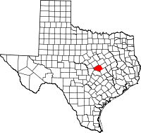 | |
| Towns | ||
| Village | ||
| CDP | ||
| Unincorporated communities |
| |
| Ghost towns |
| |
| Footnotes | ‡This populated place also has portions in an adjacent county or counties | |
