Abilene, Texas
| Abilene, Texas | ||
|---|---|---|
| City | ||
| City of Abilene | ||
|
Downtown Abilene | ||
| ||
|
Nickname(s):
| ||
 Location in the state of Texas | ||
| Coordinates: 32°27′N 99°45′W / 32.450°N 99.750°WCoordinates: 32°27′N 99°45′W / 32.450°N 99.750°W | ||
| Country |
| |
| State |
| |
| Counties |
Taylor Jones | |
| Settled | 1881[1] | |
| Incorporated (town) | 1881[1] | |
| County Seat | 1883[1] | |
| Named for | Abilene, Kansas[1] | |
| County Seat | Taylor County | |
| Government | ||
| • Type | Council-Manager | |
| • City Council |
Mayor Norm Archibald, Shane Price Bruce Kreitler Anthony Williams Jay Hardaway Kyle McAlister Steve Savage | |
| • City Manager | Robert Hanna | |
| Area | ||
| • City | 110.6 sq mi (286.5 km2) | |
| • Land | 105.1 sq mi (272.3 km2) | |
| • Water | 5.5 sq mi (14.2 km2) | |
| Elevation | 1,719 ft (524 m) | |
| Population (2010)[2] | ||
| • City | 117,063 | |
| • Estimate (2015)[2] | 121,721 | |
| • Density | 1,113/sq mi (429.9/km2) | |
| • Urban | 107,041 | |
| • Metro | 165,252 | |
| • Demonym | Abilenian | |
| Time zone | CST (UTC-6) | |
| • Summer (DST) | CDT (UTC-5) | |
| ZIP codes | 79600-79699 | |
| Area code(s) | 325 | |
| FIPS code | 48-01000[3] | |
| GNIS feature ID | 1329173[4] | |
| Website | abilenetx.com | |


Abilene (/ˈæbᵻliːn/ AB-i-LEEN) is a city in Taylor and Jones counties in west-central Texas, United States. The population was 117,063 according to the 2010 census, making it the 27th-most populous city in the state of Texas. It is the principal city of the Abilene Metropolitan Statistical Area, which had a 2011 estimated population of 166,416.[5] It is the county seat of Taylor County.[6] Dyess Air Force Base is located on the west side of the city.
Abilene is located off Interstate 20, between exits 279 on its western edge and 292 on the east. Abilene is 150 miles (240 km) west of Fort Worth, Texas. The city is looped by I-20 to the north, US 83/84 on the west, and Loop 322 to the east. A railroad divides the city down the center into north and south. The historic downtown area is on the north side of the railroad.
The fastest-growing sections of the city are growing to the southwest, along Southwest Drive, the Winters Freeway, and the Buffalo Gap Road corridor; the southeast, along Loop 322, Oldham Lane, Industrial Drive, and Maple Street; and in the northeast near the intersection of SH 351 and I-20. Many developments have begun in these three areas within the last few years. Three lakes are in the city, Lytle Lake on the western edge of Abilene Regional Airport, Kirby Lake on the southeast corner of the US 83/84 and Loop 322 interchange, and Lake Fort Phantom Hill in Jones County in northern Abilene.
History


Established by cattlemen as a stock shipping point on the Texas and Pacific Railway in 1881, the city was named after Abilene, Kansas,[1][7] the original endpoint for the Chisholm Trail. The T&P had bypassed the town of Buffalo Gap, the county seat at the time. Eventually, a landowner north of Buffalo Gap, Clabe Merchant, known as the father of Abilene, chose the name for the new town. According to a Dallas newspaper, about 800 people had already begun camping at the townsite, before the lots were sold. The town was laid out by Colonel J. Stoddard Johnson, and the auction of lots began early on March 15, 1881. By the end of the first day, 139 lots were sold for a total of $23,810, and another 178 lots were sold the next day for $27,550.
Abilene was incorporated soon after being founded in 1881,[1] and Abilenians began to set their sights on bringing the county seat to Abilene, and in a three-to-one vote, won the election. In 1888, the Progressive Committee was formed to attract businesses to the area, which later became the Board of Trade in 1890. By 1900, 3,411 people lived in Abilene, and in that decade, the Board of Trade changed its name to the 25,000 Club in the hope of reaching 25,000 people by the next census. However, this committee failed when the population only hit 9,204 in 1910. Replacing it was the Young Men's Booster Club, which became the Abilene Chamber of Commerce in 1914.
The cornerstone was laid for the first of three future universities in Abilene, called Simmons College, in 1891,[1] which later became Hardin-Simmons University. Childers Classical Institute followed in 1906,[1] currently Abilene Christian University, the largest of the three. In 1923, McMurry College was founded and later became McMurry University.[1] Much more recently, Abilene succeeded in bringing Cisco Junior College and Texas State Technical College branches to Abilene, with the Cisco Junior College headquarters being located in Abilene.
In 1940, Abilene raised the money to purchase land for a U.S. Army base, southwest of town, named Camp Barkeley, which was at the time, twice the size of Abilene with 60,000 men. When the base closed, many worried that Abilene could become a ghost town, but in the post-World War II boom, many servicemen returned to start businesses in Abilene. In the early-1950s, residents raised $893,261 to purchase 3,400 acres (14 km2) of land for an air force base. Today, Dyess Air Force Base is the city's largest employer, with 6,076 employees.[8][9] By 1960, Abilene's population nearly doubled in 10 years from 45,570 in 1950 to 90,638. In the same year, a second high school was added, Cooper High School. In 1966, the Abilene Zoo was created near Abilene Regional Airport. The following year, one of the most important bond elections in the city's history passed for the funding of the construction of the Abilene Civic Center and the Taylor County Coliseum, as well as major improvements to Abilene Regional Airport. In 1969, the Woodson elementary and high school for black students closed as the schools are integrated.
In 1982, Abilene became the first city in Texas to create a downtown reinvestment zone. Texas State Technical College opened an Abilene branch three years later. The 2,250-bed French Robertson Prison Unit was built in 1989. A half-cent sales tax earmarked for economic development was created after the decline in the petroleum business in the 1980s. The Grace Museum and Paramount Theatre revitalizations, along with Artwalk in 1992, sparked a decade of downtown restoration. In 2004, Frontier Texas!, a multimedia museum highlighting the history of the area from 1780 to 1880 was constructed, and a new $8 million, 38-acre (150,000 m2) Cisco Junior College campus was built at Loop 322 and Industrial Boulevard. Simultaneously, subdivisions and businesses started locating along the freeway, on the same side as the CJC campus, showing a slow but progressive trend for Abilene growth on the Loop. Abilene has become the commercial, retail, medical, and transportation hub of a 19-county area more commonly known as "The Big Country", but also known as the "Texas Midwest", and is part of the Central Great Plains ecology region. By the end of 2005, commercial and residential development had reached record levels in and around the city.[10]
Geography
Abilene is located 150 miles (241 km) west by south of Fort Worth.
According to the United States Census Bureau, the city has a total area of 110.6 square miles (286.5 km²), of which 105.1 square miles (272.3 km²) are land and 5.5 square miles (14.2 km²) are covered by water (4.95%).
Climate
According to the Köppen climate classification, Abilene lies at the edge of a humid subtropical climate, with areas to the west being semiarid.
| Climate data for Abilene, Texas (1981−2010 normals) | |||||||||||||
|---|---|---|---|---|---|---|---|---|---|---|---|---|---|
| Month | Jan | Feb | Mar | Apr | May | Jun | Jul | Aug | Sep | Oct | Nov | Dec | Year |
| Record high °F (°C) | 90 (32) |
94 (34) |
98 (37) |
104 (40) |
109 (43) |
110 (43) |
110 (43) |
111 (44) |
107 (42) |
103 (39) |
92 (33) |
89 (32) |
111 (44) |
| Average high °F (°C) | 56.8 (13.8) |
60.5 (15.8) |
68.6 (20.3) |
77.3 (25.2) |
84.6 (29.2) |
90.5 (32.5) |
94.2 (34.6) |
94.0 (34.4) |
86.8 (30.4) |
77.3 (25.2) |
66.3 (19.1) |
56.9 (13.8) |
77.0 (25) |
| Average low °F (°C) | 33.0 (0.6) |
37.0 (2.8) |
44.4 (6.9) |
51.9 (11.1) |
61.4 (16.3) |
68.8 (20.4) |
71.2 (21.8) |
70.7 (21.5) |
63.5 (17.5) |
53.6 (12) |
42.3 (5.7) |
33.6 (0.9) |
52.6 (11.4) |
| Record low °F (°C) | −9 (−23) |
−7 (−22) |
9 (−13) |
25 (−4) |
33 (1) |
44 (7) |
54 (12) |
48 (9) |
38 (3) |
23 (−5) |
13 (−11) |
−7 (−22) |
−9 (−23) |
| Average precipitation inches (mm) | 1.02 (25.9) |
1.36 (34.5) |
1.74 (44.2) |
1.64 (41.7) |
3.18 (80.8) |
3.56 (90.4) |
1.87 (47.5) |
2.59 (65.8) |
2.24 (56.9) |
2.98 (75.7) |
1.41 (35.8) |
1.23 (31.2) |
24.82 (630.4) |
| Average snowfall inches (cm) | 1.8 (4.6) |
0.9 (2.3) |
0.4 (1) |
0.4 (1) |
0 (0) |
0 (0) |
0 (0) |
0 (0) |
0 (0) |
0 (0) |
0.5 (1.3) |
1.2 (3) |
5.2 (13.2) |
| Average precipitation days (≥ 0.01 in) | 4.7 | 5.4 | 6.0 | 5.0 | 7.7 | 7.0 | 5.1 | 5.9 | 5.8 | 6.6 | 4.6 | 5.1 | 68.9 |
| Average snowy days (≥ 0.1 in) | 0.9 | 0.7 | 0.3 | 0 | 0 | 0 | 0 | 0 | 0 | 0 | 0.3 | 0.6 | 2.8 |
| Mean monthly sunshine hours | 204.6 | 203.4 | 263.5 | 282.0 | 306.9 | 330.0 | 347.2 | 316.2 | 258.0 | 248.0 | 198.0 | 192.2 | 3,150 |
| Source: National Weather Service, San Angelo[11] Hong Kong Observatory (sun only, 1961–1990)[12] | |||||||||||||
Demographics
| Historical population | |||
|---|---|---|---|
| Census | Pop. | %± | |
| 1890 | 3,194 | — | |
| 1900 | 3,411 | 6.8% | |
| 1910 | 9,204 | 169.8% | |
| 1920 | 10,274 | 11.6% | |
| 1930 | 23,175 | 125.6% | |
| 1940 | 26,612 | 14.8% | |
| 1950 | 45,570 | 71.2% | |
| 1960 | 90,368 | 98.3% | |
| 1970 | 89,653 | −0.8% | |
| 1980 | 98,315 | 9.7% | |
| 1990 | 106,707 | 8.5% | |
| 2000 | 115,930 | 8.6% | |
| 2010 | 117,063 | 1.0% | |
| Est. 2015 | 121,721 | [13] | 4.0% |
| U.S. Census Bureau[14] Texas Almanac[15] | |||
As of the census[3] of 2000, 115,930 people, 41,570 households, and 28,101 families resided in the city. The population density was 1,102.7 people per square mile (425.8/km²). The 45,618 housing units averaged 433.9 per square mile (167.5/km²). The racial makeup of the city was 78.07% White, 8.81% African American, 0.55% Native American, 1.33% Asian, 0.07% Pacific Islander, 8.73% from other races, and 2.44% from two or more races. Hispanics or Latinos of any race were 19.45% of the population.
Of the 41,570 households, 34.2% had children under the age of 18 living with them, 52.0% were married couples living together, 11.9% had a female householder with no husband present, and 32.4% were not families. About 26.6% of all households were made up of individuals, and 9.8% had someone living alone who was 65 years of age or older. The average household size was 2.53 and the average family size was 3.07.
In the city, the population was distributed as 25.6% under the age of 18, 15.3% from 18 to 24, 28.9% from 25 to 44, 18.2% from 45 to 64, and 12.0% who were 65 years of age or older. The median age was 31 years. For every 100 females, there were 102.0 males. For every 100 females age 18 and over, there were 101.1 males.
The median income for a household in the city was $33,007, and for a family was $40,028. Males had a median income of $28,078 versus $20,918 for females. The per capita income for the city was $16,577. About 10.9% of families and 15.4% of the population were below the poverty line, including 18.6% of those under age 18 and 9.2% of those age 65 or over.
As of the 2010 census, Abilene had a population of 117,063. The racial and ethnic makeup of the population was 62.4% non-Hispanic White, 9.6% Black or African American, 0.7% Native American, 1.7% Asian, 0.1% Pacific Islander, 0.1% non-Hispanic reporting some other race, 3.3% of two or more races, and 24.5% Hispanic or Latino.
Government and infrastructure
The Texas Department of Criminal Justice (TDCJ) operates the Abilene District Parole Office in the city.[16] The Robertson Unit prison and the Middleton Unit transfer unit are in Abilene and in Jones County.[17][18][19]
The United States Postal Service operates the Abilene Post Office and the Abilene Southern Hills Post Office.[20][21]
Education
Secondary education
Abilene has two school districts within the city limits, the Abilene Independent School District (AISD) and Wylie Independent School District (WISD). The local high schools are Abilene High School and Cooper High School of AISD and Wylie High School of WISD. A new building on the Hardin-Simmons University campus serves AISD high school students as a magnet school, called Holland Medical High School, as well as HSU students as the Holland School of Sciences and Mathematics. The Holland Medical High School is affiliated with Hendrick Medical Center, which is across Ambler Avenue from the university campus. Abilene also has a new high school that opened in the fall of 2009, the Academy of Technology, Engineering, Mathematics, and Science. It is a STEM school, which focuses on computer science, engineering science, and mathematics. The school only accepts about 100 students each year, provides students with their own laptop computers, and is located inside the Abilene campus of Texas State Technical College.
AISD has begun taking steps towards creating magnet schools for the school district. The district is considering locating a specialized math and science classroom at McMurry University, taught by both a university professor and AISD teacher, on the campus. A plan for the future calls for the creation of a magnet school system specializing in four areas: math, science, technology, and fine arts. The four areas will be divided among each of the four middle schools in the district. Regular curriculum will still be taught, but extra emphasis and equipment would be given based on the specific field of the school, such as extra labs for a science school, and an instrument lab for a fine arts school.[22] Also, Bond Proposition 2 for the 2008 AISD bond election proposed a new Professional and Technology magnet school to be located at Lincoln Middle School,[23] one of the oldest schools in the city, after a major renovation project.
Rankings
Abilene ranked by Business Outlook magazine as the 17th city in the nation for their public education system in 2006, the highest-ranked city in Texas.[24]
Colleges and universities
Abilene is home to seven colleges, three of which are religiously affiliated. Hardin-Simmons University is the oldest, founded in 1891. Abilene Christian University is the largest with their 2012 undergraduate enrollment at 4,371.
| Name | Affiliation | Founded | Enrollment |
|---|---|---|---|
| Abilene Christian University | Churches of Christ | 1906 | 4,371[25] |
| Abilene Commercial College | 1963 | 200[26] | |
| Cisco College | 1972[27] | 3,806[25] | |
| Hardin-Simmons University | Baptist | 1891 | 2,301[25] |
| McMurry University | Methodist | 1923 | 1,372[25] |
| Texas State Technical College West Texas | 1985 | 1,049[25] | |
| Texas Tech University Health Sciences Center Abilene Campus | 2006 | 320 |
Other
Abilene is also home to two Charismatic and Pentecostal Christianity schools of ministry. One is Iris Abilene Camp Barkeley founded by Norm and Angel Poorman, affiliated with Heidi Baker,[28][29][30] and the other is the Transformation School of Supernatural Ministry (TSSM) founded by Amy Black.[31][32]
Notable buildings
The many historical buildings in Abilene include:
- Marshal Tom Hill House in Buffalo Gap Historic Village south of Abilene echoes a moving human interest story. When Hill died in an accidental shooting at 32 years of age in 1886, his wife, Mollie, and daughter, Belle, were left to provide for themselves in difficult times over six decades.
- The Dodd-Harkrider House at 2026 North Third Street is a two-story Four-Square dwelling; it provides a glimpse into the Americana of 1915.
- Wooten Hotel (1930) at 302 Cypress Street downtown, built by grocery entrepreneur H. O. Wooten, at 16 stories tall, is designed after the Drake Hotel in Chicago. It was restored in 2004 as apartments for the upwardly mobile.
- First Baptist Church (1954) at 1442 North Second Street has a spire 140 feet from the ground. Pastor Dr. Jesse Northcutt oversaw the planning of this building of 325 tons of steel.
- The Church of the Heavenly Rest, Episcopal, at 602 Meander Street, reflects surprising Gothic architecture on the West Texas Plains. Its plaque reads: "No man entering a house ignores him who dwells in it. This is the house of God and He is here."
- The Moreland-Shaheen House, 1120 Elmwood Drive, is a 1946 Art Moderne dwelling, shaded by six fruit trees, and is also referred to as the "Sugar House" because Henry Moreland operated the Abilene Dr Pepper and 7-Up bottling companies.
An Abilene dwelling has an indirect link to Hollywood actress Joan Crawford: her father, Thomas LeSeur, was a construction laborer on the George R. Davis House at 718 Victoria Street, built in 1930 in Prairie School architecture.
- The 20-story Enterprise Building at 500 Chestnut Street, the highest structure in Abilene, rises to 283 feet above the Plains.
- The Taylor County Courthouse at 300 Oak Street, with its international architectural style of concrete and pink granite, resembles few other courthouses.
- Paramount Theatre at 352 Cypress Street opened in 1930 and restored in 1986 had an original marquee 90 feet tall, with 1,400 lights.
- Abilene Courts at 633 South Eleventh Street, a defunct motel built in 1930 alongside the Bankhead Highway (the precursor to U.S. Highway 80 and Interstate 20) reflects the Abilene of yesteryear.[33]
- Lincoln Junior High School, 1699 South First Street. In 2012, the Abilene Independent School District deeded the property to the City of Abilene. This property, known as Lincoln Junior High was placed on the National Register of Historic Places, August 28, 2012. Built in 1923, the architecture is Gothic Revival and includes two large gargoyles at the entrance and has Gothic and art deco motifs. It opened as Abilene High School in 1924, then became Lincoln Junior High in 1955, then Lincoln Middle School in 1985, and closed in 2007.
Health care
The largest hospital facility in the area is the Hendrick Medical Center, opened in 1934, and now consists of a 504-bed hospital facility, and employs 2,600 staff. It is one of seven healthcare institutions affiliated with the Baptist General Convention of Texas.[34]
The Abilene Regional Medical Center was built by a group of physicians in 1968 as the West Texas Medical Center. It has a 231-bed hospital, with 200 physicians and 800 staff.[35]
The Presbyterian Medical Care Mission was founded in 1983 as a medical and dental clinic. Its services are focused to low-income individuals and families without insurance.[36]
Culture
The cultural aspects of Abilene center around a mix of the local college and university campuses, the agriculture community of the surrounding area, and the numerous evangelical churches present. The Abilene Arts Alliance captured the essence of the city with "Frontiering", a brand name for the city introduced in November 2008 to connect its pioneer spirit with its modern efforts to push the boundaries of education, technology, transportation, energy, the arts, and health care. Abilene is also home to the restored Paramount Theatre, The Abilene Philharmonic, The Grace Museum, the Center for Contemporary Arts, the National Center for Children's Illustrated Literature, The Abilene Zoo, Frontier Texas!, the 12th Armored Division Museum, Taylor County Coliseum, six libraries (three private, three public), 26 public parks, six television stations, and several radio stations, including one NPR station (89.5 KACU).
Economy
The economy in Abilene was originally based on the livestock and agricultural sectors,[1] but has since evolved and is now based strongly on government, education, healthcare, and manufacturing. The petroleum industry is prevalent in the surrounding area also.[1] The city has established incentives to bring new businesses to the area, including job training grants, relocation grants, and more.[37]
Top employers
The top 10 employers in Abilene, as of June 2014, are:[38]
| Rank | Employer | # of Employees | Industry |
|---|---|---|---|
| 1 | Dyess Air Force Base | 5406 | Government |
| 2 | Hendrick Health System | 2896 | Healthcare |
| 3 | Abilene ISD | 2450 | Education |
| 4 | Abilene State Supported Living Center | 1472 | Government |
| 5 | City of Abilene | 1200 | Government |
| 6 | Texas Department of Criminal Justice | 1190 | Government |
| 7 | Blue Cross Blue Shield of Texas Claims Center | 1050 | Call Center |
| 8 | Abilene Christian University | 850 | Education |
| 9 | Abilene Regional Medical Center | 760 | Healthcare |
| 10 | Taylor County | 550 | Government |
Recreation and entertainment
Park system
The Abilene park system includes 29 parks, occupying a total of 1,247.56 acres (5.0487 km2). In addition, three athletic complexes located throughout the city are under the jurisdiction of the parks department.

The Abilene Zoo is a popular attraction in Abilene, boasting several hundred animals of various species. It hosts educational and summer programs, as well as special events throughout the year.
Events
The West Texas Fair and Rodeo, held annually for 10 days in mid-September, features exhibits and amusements reflecting early days of Abilene, plus modern attractions of West Texas.
The Western Heritage Classic in early May features ranch rodeo, campfire cook-off, sheepdog trials, farrier competition, cowboy poets, a Western art show, and many other activities.
On every second Thursday evening of the month, Artwalk is held in downtown Abilene. During Artwalk, all the local museums are free, local musicians and performers busk, and several crafters and artists set up booths and sell their wares.
Several special-interest conventions, festivals, and shows are scattered throughout the year, including the Abilene Gem and Mineral Show, the West Texas Book and Music Festival, the Abilene Gun and Knife Show, and the Friends of the Abilene Public Library book sale.
Also of note is the annual Abilene High vs. Cooper High football game, the Crosstown Showdown, usually held near Halloween. Two of these games, in 2001 and 2002, were for the district championship and were called the "Showdown at Shotwell" as games were played at Shotwell Stadium.
Photo gallery
-

Abilene banner
-

Federal Building (Courthouse and Post Office) in Abilene
-

Abilene City Hall
-

Windsor Hotel
-

Looking down the row of shops on Abilene's historic Cypress Street
-

Vera Hall Minter Park at North 2nd and Cypress Street
-

Downtown Paramount Theatre (established 1930)
-
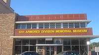
12th Armored Division Memorial Museum
-

Looking south down Cypress Street toward Abilene's tallest building, the Bank of America Tower
-

First Central Presbyterian Church in Abilene, pastor Clifford S. Stewart (2013)
-

Hardin-Simmons University emblem
Media
Newspapers
The Abilene Reporter-News is the primary daily newspaper of the city of Abilene and the surrounding Big Country area.
Television
Radio
- 88.1 FM KGNZ (Christian Contemporary)
- 89.5 FM KACU (Public Radio)
- 90.5 FM KAGT (Christian Contemporary)
- 91.3 FM KAQD (Religious)
- 91.7 FM KQOS (Religious)
- 92.5 FM KMWX (Adult Contemporary)
- 93.3 FM KBGT (Tejano)
- 94.1 FM KVVO (Inspirational Country)
- 95.1 FM KABW (Country)
- 96.1 FM KORQ (Top 40)
- 98.1 FM KTLT (Sports Talk)
- 99.7 FM KBCY (Country)
- 100.7 FM KULL (Classic Hits)
- 102.7 FM KHXS (Classic Rock)
- 103.7 FM KCDD (Top 40)
- 105.1 FM KEAN (Country)
- 106.3 FM KKHR (Regional Mexican)
- 106.9 FM KLGD (Country)
- 107.9 FM KEYJ (Active Rock)
- 1280 AM KSLI (Country)
- 1340 AM KWKC (News Talk)
- 1470 AM KYYW (News Talk)
- 1560 AM KZQQ (Sports Talk)
Transportation
Major highways
|
Airport
The city of Abilene is served by Abilene Regional Airport.
Notable people
- B W Aston (1936–2010), historian
- Raleigh Brown, member of the Texas House of Representatives and a state-court judge
- Doyle Brunson, two-time World Series of Poker champion, attended and played basketball at Hardin-Simmons College before injuring his knee.
- Victor G. Carrillo, chairman of Texas Railroad Commission, county judge of Taylor County, member of Abilene City Council
- Randall "Tex" Cobb, heavyweight boxer and actor
- Charles Coody, Masters-winning professional golfer (from Stamford and Abilene) — graduate of ACU[39]
- Roy Crane, nationally syndicated cartoonist (Wash Tubbs, Captain Easy, Buz Sawyer)
- Bob Estes, professional golfer
- Jack Favor, rodeo star, falsely imprisoned in 1967 in Louisiana for two murders for which he was framed, released with acquittal in a second trial in 1974; lived in Abilene in childhood and graduated from Abilene High School in 1929[40]
- W. C. Friley, first president of Hardin-Simmons University, 1892-1894
- Billy Gillispie, former Texas Tech University Red Raiders, Kentucky, and Texas A&M men's basketball coach
- Ryan Guzman, actor
- Homer Hailey (1903-2000), Church of Christ clergyman and professor at Abilene Christian University
- David W. Harper (born 1961), actor, played James Robert Walton on CBS television series The Waltons, 1972–1981
- Kristy Hawkins (born 1980), IFBB professional bodybuilder
- Jerry Herron (born 1949), Dean of Wayne State University Honors College
- Micah P. Hinson, indie rock singer
- Robert Dean Hunter, member of Texas House of Representatives from Abilene, 1986-2007; vice president emeritus of Abilene Christian University
- Susan King, member of Texas House of Representatives from Abilene since 2007; surgical nurse, rancher, and businesswoman
- Johnny Knox, former wide receiver for the Chicago Bears
- Bill Jones, former NFL player for the Kansas City Chiefs
- Morgan Jones, railroad builder
- Case Keenum, quarterback for the Los Angeles Rams
- John Lackey, starting pitcher for the Chicago Cubs
- Gary D. McCaleb, mayor of Abilene, 1990–1999; vice-president of Abilene Christian University
- Billy Maxwell, golfer, winner of seven PGA Tour events
- Mildred Paxton Moody, wife of Governor Dan Moody
- Bobby Morrow, three-time gold medal winner at 1956 Olympic Games in Melbourne, Australia, named Sportsman of the Year in 1956 by Sports Illustrated
- Billy Olson, pole vaulter (1988 Summer Olympics, for the U.S. team that boycotted the 1980 Summer Olympics); held several world records, including first 19-foot (5.8 m) indoor pole vault — vaulted for AHS and ACU[39][41][42][43][44]
- Ty O'Neal, rodeo cowboy and film actor
- Terry Orr, tight end for the Washington Redskins — played for CHS[39]
- Vinnie Paul, (born in Abilene), musician, co-founder, and drummer of heavy metal band Pantera and Damageplan, drummer of Hellyeah
- Rawson Stovall, video game producer, author, and first nationally syndicated reviewer of video games
- Fess Parker (1924–2010), actor, hotel and winery owner, attended Hardin-Simmons University, played football at HSU before transferring to University of Texas, starred in TV as Davy Crockett and Daniel Boone
- Lee Roy Parnell, country musician
- Charles Perry, incoming 2011 member of Texas House of Representatives from Lubbock, was born in Abilene in 1962
- Rupert N. Richardson, historian and president of Hardin-Simmons University
- Lou Halsell Rodenberger, author and biographer of Jane Gilmore Rushing, professor at McMurry University
- Bill Sharman, Hall-of-Fame NBA basketball player and coach, born in Abilene
- Jessica Simpson, singer and actress, born in Abilene
- Jorge A. Solis (1951-), United States Federal Judge, 5th Circuit
- Sarah Weddington, lawyer, represented "Jane Roe" in case of Roe v. Wade.
- Ann Wedgeworth, actress[45]
- Mason Williams, musician, best known for his guitar instrumental "Classical Gas"
Sister cities
 Río Cuarto, Argentina
 Chita, Russia[46]
In popular culture
- The movie Friday Night Lights features games with two AISD football teams, Abilene High and Cooper High. Some scenes were filmed at Shotwell Stadium, the location of both teams' home games.
See also
Further reading
- Abilene Landmarks: An Illustrated Tour: The Story of Abilene as told through 100 of its most historic buildings, Buffalo Gap, Texas: State House Press. 2009. ISBN 978-1-93333-730-2.
- Abilene Stories: From Then to Now, Abilene, Texas: Abilene Christian University Press. 2013. ISBN 978-0-89112-368-2.
- Lost Abilene: Images of America, Charleston, South Carolina: Arcadia Publishing. 2013. ISBN 978-0-73859-693-8.
References
- 1 2 3 4 5 6 7 8 9 10 11 Hoiberg, Dale H., ed. (2010). "Abilene". Encyclopedia Britannica. I: A-ak Bayes (15th ed.). Chicago, IL: Encyclopedia Britannica Inc. pp. 32–33. ISBN 978-1-59339-837-8.
- 1 2 "State and County Quick Facts". United States Census Bureau. Retrieved January 6, 2015.
- 1 2 "American FactFinder". United States Census Bureau. Archived from the original on 2013-09-11. Retrieved 2008-01-31.
- ↑ "US Board on Geographic Names". United States Geological Survey. 2007-10-25. Retrieved 2008-01-31.
- ↑ "Metropolitan and Micropolitan Statistical Areas". 2011 Population Estimates. United States Census Bureau, Population Division. July 1, 2011. Retrieved November 26, 2012.
- ↑ "Find a County". National Association of Counties. Archived from the original on 2011-05-31. Retrieved 2011-06-07.
- ↑ Gannett, Henry (1905). The Origin of Certain Place Names in the United States. p. 22. ISBN 0-7884-0579-9.
- ↑ Archived October 11, 2007, at the Wayback Machine.
- ↑ "History of Abilene "From railroad tracks to vapor trails"". myabilene.com. Archived from the original on October 9, 2007. Retrieved 2 October 2012.
- ↑ Archived October 9, 2007, at the Wayback Machine.
- ↑ "Abilene Climate Data". National Weather Service, San Angelo. Retrieved 2014-07-21.
- ↑ "Climatological Normals of Abilene". Hong Kong SAR Government. Retrieved 2011-12-10.
- ↑ "Annual Estimates of the Resident Population for Incorporated Places: April 1, 2010 to July 1, 2015". Retrieved July 2, 2016.
- ↑
- ↑
- ↑ "Parole Division Region V." Texas Department of Criminal Justice. Retrieved on May 22, 2010.
- ↑ "Super Neighborhood Areas." (Direct map link) City of Abilene. Retrieved on July 23, 2010.
- ↑ "Robertson Unit." Texas Department of Criminal Justice. Retrieved on July 23, 2010.
- ↑ "Middleton Unit." Texas Department of Criminal Justice. Retrieved on July 23, 2010.
- ↑ "Post Office Location - ABILENE." United States Postal Service. Retrieved on May 22, 2010.
- ↑ "Post Office Location - ABILENE SOUTHERN HILLS." United States Postal Service. Retrieved on May 22, 2010.
- ↑ "Attracting magnet schools". Reporter News. 2008-03-27. Retrieved 2015-07-12.
- ↑ "Lincoln a Magnet School?". reporternews.com. April 12, 2008.
- ↑ Archived August 18, 2008, at the Wayback Machine.
- 1 2 3 4 5 Fowler, Ethan (12 September 2012). "Tarleton State, TSTC increase fall enrollments; other Big Country schools decline". Abilene Reporter News. Retrieved 19 July 2013.
- ↑ Adame, Jamie (2 November 2012). "American Commercial College students in Abilene sent home as federal agents with Dept. of Education take over". Abilene Reporter News. Retrieved 19 July 2013.
- ↑ Bethel, Brian (27 January 2006). "Cisco Junior College Abilene outgrows building". Abilene Reporter News. Retrieved 19 July 2013.
- ↑ http://www.irisglobal.org/abilene/team
- ↑ http://irisabilene.org/
- ↑ http://www.irisglobal.org/about/history
- ↑ http://www.transformationschool.com/history-of-tssm
- ↑ http://www.transformationschool.com/
- ↑ Donald S. Frazier and Robert F. Pace, with photographs by Steve Butman, Abilene Landmarks: An Illustrated Tour (Abilene Texas: State House Press at McMurry University, 2008) ISBN 978-193333730-2
- ↑ "About Us". ehendrick.org. Retrieved 2 October 2012.
- ↑ "About Us". abileneregional.com. Retrieved 2 October 2012.
- ↑ "Medical Care Mission : Abilene". medicalcaremission.org. Retrieved 2 October 2012.
- ↑ "Incentives : Abilene Industrial Foundation". Archived from the original on 26 January 2013. Retrieved 22 January 2013.
- ↑ "Major Employers". Archived from the original on 27 June 2015. Retrieved 15 September 2015.
- 1 2 3 Al Pickett. "Abilene has produced more than its share of stars," Abilene Reporter-News, December 24, 1999.
- ↑ "Not Guilty" (PDF). cowboysforchrist.net. Retrieved February 6, 2014.
- ↑ "Information about Abilene Christian University". Acu.edu. Retrieved 2015-07-12.
- ↑ Ted Dunnam. "Coaching by Hood vaulted ACU over top," Abilene Reporter-News, June 25, 2000.
- ↑ All-Time U.S. Rankings — Men's Pole Vault, ranked #1 in the world for 1982.
- ↑ Frank Litsky. "Billy Olson is inching ahead on way to a 19-foot (5.8 m) vault," The New York Times, February 22, 1982, page C6, column 1 (late city final edition).
- ↑ Abilene, Texas at the Internet Movie Database
- ↑ Coe, Andre (25 April 2000). "Abilene gives Western farewell to delegates from new sister city". Abilene Reporter-News. Retrieved 21 September 2013.
External links
| Wikivoyage has a travel guide for Abilene. |
| Wikimedia Commons has media related to Abilene, Texas. |
| Wikisource has the text of the 1921 Collier's Encyclopedia article Abilene. |
Municipalities and communities of Jones County, Texas, United States | ||
|---|---|---|
| Cities |  | |
| Unincorporated communities | ||
| Footnotes | ‡This populated place also has portions in an adjacent county or counties | |
Municipalities and communities of Taylor County, Texas, United States | ||
|---|---|---|
| Cities | 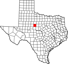 | |
| Towns | ||
| CDP | ||
| Unincorporated communities | ||
| Footnotes | ‡This populated place also has portions in an adjacent county or counties | |

| ||
| ||