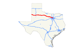
Texas State Highway 114
| |||||||
|---|---|---|---|---|---|---|---|
 | |||||||
| Route information | |||||||
| Maintained by TxDOT | |||||||
| Length: | 394.452 mi[1] (634.809 km) | ||||||
| Existed: | by 1933 – present | ||||||
| Major junctions | |||||||
| West end: |
| ||||||
|
| |||||||
| East end: |
| ||||||
| Location | |||||||
| Counties: | Cochran, Hockley, Lubbock, Crosby, Dickens, King, Knox, Baylor, Archer, Young, Jack, Wise, Denton, Tarrant, Dallas | ||||||
| Highway system | |||||||
| |||||||

State Highway 114 (or SH 114) is a state highway that runs from the Dallas-Fort Worth Metroplex westward across Texas to the state border with New Mexico, where it becomes New Mexico State Road 114, which eventually ends at Elida, New Mexico at US 70 / NM 330.
History
The route was originally planned by 1926 as connector between Dallas and Rhome. By 1933, SH 114 extended to Bridgeport. By 1939, this section was completed, with an extension northward from Chico to Sunset. This route remained little changed until 1973, when it was extended northward from Sunset to Bowie. Major rerouting was made in 1976, when the route was redirected west over U.S. Highway 380, U.S. Highway 281, former SH 199, and U.S. Highway 82 from Bridgeport to Lubbock, with the stretch from Bridgeport to Bowie transferred to SH 101. In 1977, the route was extended to the New Mexico border, connecting to it sister New Mexico State Highway 114, replacing State Highway 116. SH 116 was originally planned in 1926 to go from Dallas to Gunter. This route became an extension of SH 14 by 1936.
On August 2, 1985, Delta Air Lines Flight 191 crossed this route shortly before crashing on approach to Dallas/Fort Worth Airport. One of the aircraft's engines struck a car on the roadway, instantly killing its occupant; 136 people on the flight also died in the accident.
Route description
The highway's eastern terminus is at the intersection with SH 183 in Irving at the site of the now demolished Texas Stadium. It continues northwest as the "John W. Carpenter Freeway" (a name shared with SH 183) along the Dallas-Fort Worth International Airport, eventually crossing the airport's northern entrance, proceeding west into Grapevine. At Grapevine, it continues northwest through Southlake and Westlake, eventually intersecting Interstate 35W at Texas Motor Speedway. Except for the western end, most of this route is freeway; the SH 114 Business road in the Roanoke area (the original routing of the highway) is named for the late golfer Byron Nelson, who lived in that area.
From there, it continues on a mostly northwesterly course as a rural highway, passing through many towns: Rhome, Boyd and Bridgeport, where it joins U.S. Highway 380 through Jacksboro. It continues through rural Texas, passing through Olney, Megargel, Seymour (where it joins U.S. Highway 82), Benjamin, Guthrie, Dickens, Crosbyton, Ralls, Lorenzo (where it also joins U.S. Highway 62) and Idalou before eventually turning southwest into Lubbock.
In Lubbock, Highway 114 follows Idalou Road where it separates from US 82, then bears west along 19th Street, eventually forming the southern boundary of Texas Tech University, where it then separates from US 62. It passes Loop 289 and exits Lubbock continuing towards the west along 19th Street and then Levelland Highway. As it continues west, it passes through Smyer, Levelland, Whiteface and Morton before crossing into New Mexico.
Business routes

SH 114 has four current business routes.
- Business State Highway 114-B (formerly Loop 44) is a Business Loop that runs from SH 114 on the west side of Levelland (in west Texas) south along West Street, then east through the downtown area on Houston Street to an intersection with US 385 (College Street). The road turns left (north), concurrent with US 385, until intersecting once again at SH 114. The road was designated as Business SH 114-B in 1993, and is 1.594 miles (2.565 km) long.[2][3]
- Business State Highway 114-J (formerly Spur 440) is a Business Spur that goes east into Rhome from the intersection of US 81/US 287 and SH 114 west. The route runs along Rhome Avenue to an intersection with Business US 81-E. It is part of a previous route of SH 114. The Business route was created in 1991 and is 0.329 miles (0.529 km) long.[4][5]
- Business State Highway 114-K is a business loop that runs through Roanoke. This route runs on Byron Nelson Boulevard, along a previous route of SH 114. The business route was created in 2001 when SH 114 was rerouted further north and east around town. The route is 1.787 miles (2.876 km) long.[6]
- Business State Highway 114-L (formerly Loop 382 as well as a previous routing of SH 114) is a business loop that runs through Grapevine. This route runs east on Northwest Highway to an intersection with Texan Trail, then turns right to go southbound there. The road continues until it reaches SH 114/SH 121. The portion of the business route along Texan Trail is concurrent with SH 26. The route was created in 1991 when the road's designation as Loop 382 was discontinued. The route is 2.074 miles (3.338 km) long.[7][8]
Former Business routes
There is one former Business Route along SH 114. Business State Highway 114-H was located in Bridgeport between 1991 and 2007 and was 1.3 miles (2.1 km) long. The route went east along Halsell Avenue from an intersection with SH 114, to an intersection with 13th Street, then turned right (south) until another intersection with SH 114. This route had been previously designated Loop 373 before 1991; since 2007, though, the portion along 13th was changed back to Loop 373.[9][10]
Major intersections
| County | Location | mi[11] | km | Destinations | Notes | ||
|---|---|---|---|---|---|---|---|
| Cochran | | 0.0 | 0.0 | New Mexico state line | |||
| Griffith | 1.7 | 2.7 | |||||
| | 8.5 | 13.7 | South end of FM 596 | ||||
| Star Route | 10.6 | 17.1 | North end of FM 3304 | ||||
| Morton | 17.0 | 27.4 | |||||
| | 19.8 | 31.9 | North end of FM 2195 | ||||
| | 24.2 | 38.9 | South end of FM 1337 | ||||
| | 28.8 | 46.3 | West end of overlap with FM 1780 | ||||
| | 28.9 | 46.5 | East end of overlap with FM 1780 | ||||
| Hockley | | 33.9 | 54.6 | West end of overlap with FM 303 | |||
| | 35.3 | 56.8 | East end of overlap with FM 303 | ||||
| | 41.1 | 66.1 | South end of FM 1490 | ||||
| Levelland | 42.1 | 67.8 | East end of Bus. SH 114-B | ||||
| 43.2 | 69.5 | West end of Bus. SH 114-B | |||||
| | 45.8 | 73.7 | |||||
| | 49.0 | 78.9 | |||||
| Smyer | 54.4 | 87.5 | West end of overlap with FM 168 | ||||
| 55.0 | 88.5 | East end of overlap with FM 168 | |||||
| | 57.1 | 91.9 | South end of FM 2130 | ||||
| Lubbock | | 59.8 | 96.2 | ||||
| Lubbock | 62.9 | 101.2 | Formerly Quitsna Avenue, south end of Spur 309 | ||||
| 63.9 | 102.8 | ||||||
| 67.6 | 108.8 | interchange | |||||
| 70.2 | 113.0 | interchange; no direct access from SH 114 east to US 62 west / US 82 west, US 62 east / US 82 east to SH 114 west, or US 82 west to SH 114 east; west end of US 62 overlap | |||||
| 72.8 | 117.2 | ||||||
| 73.6 | 118.4 | I-27 exit 3 | |||||
| 73.8 | 118.8 | Avenue A | former US 87 Bus. | ||||
| 76.3 | 122.8 | West end of FM 40 | |||||
| 76.9 | 123.8 | interchange; no eastbound exit; west end of US 82 overlap | |||||
| see US 82 | |||||||
| Baylor | Seymour | 230.3 | 370.6 | east end of US 82 overlap; west end of US 183 Bus. / US 277 Bus. / US 283 Bus. overlap | |||
| 231.0 | 371.8 | east end of US 183 Bus. / US 277 Bus. / US 283 Bus. overlap | |||||
| 231.8 | 373.0 | Interchange | |||||
| | 232.1 | 373.5 | |||||
| | 235.6 | 379.2 | |||||
| | 240.3 | 386.7 | |||||
| | 242.2 | 389.8 | |||||
| Archer | | 251.8 | 405.2 | ||||
| Megargel | 253.2 | 407.5 | West end of overlap with FM 210 | ||||
| 253.3 | 407.6 | East end of overlap with FM 210 | |||||
| Young | | 263.3 | 423.7 | West end of overlap with FM 2178 | |||
| | 263.6 | 424.2 | East end of overlap with FM 2178 | ||||
| Olney | 264.3 | 425.3 | |||||
| 265.1 | 426.6 | ||||||
| Jean | 274.9 | 442.4 | |||||
| | 278.6 | 448.4 | |||||
| Loving | 282.2 | 454.2 | |||||
| Jack | | 287.7 | 463.0 | ||||
| Jermyn | 289.4 | 465.7 | West end of overlap with FM 1191 | ||||
| 289.7 | 466.2 | East end of overlap with FM 1191 | |||||
| | 295.8 | 476.0 | West end of overlap with US 281 | ||||
| Jacksboro | 302.4 | 486.7 | South end of SH 148 | ||||
| 303.2 | 488.0 | West end of overlap with US 380 / SH 199 | |||||
| 304.0 | 489.2 | East end of Park Road 61 | |||||
| | 305.7 | 492.0 | East end of overlap with US 281 / SH 199 | ||||
| | 312.3 | 502.6 | |||||
| Vineyard | 316.3 | 509.0 | |||||
| Wise | Bridgeport | 325.7 | 524.2 | ||||
| 328.6 | 528.8 | ||||||
| 329.4 | 530.1 | East end of overlap with US 380, south end of SH 101 | |||||
| 329.8 | 530.8 | ||||||
| 330.4 | 531.7 | ||||||
| 331.1 | 532.9 | ||||||
| Paradise | 336.0 | 540.7 | |||||
| 336.8 | 542.0 | ||||||
| | 339.5 | 546.4 | West end of overlap with FM 51 | ||||
| | 340.8 | 548.5 | East end of overlap with FM 51; interchange | ||||
| Boyd | 346.0 | 556.8 | West end of overlap with FM 730 | ||||
| 346.5 | 557.6 | East end of overlap with FM 730 | |||||
| Aurora | 348.9 | 561.5 | |||||
| Rhome | 351.1 | 565.0 | Interchange, west end of overlap with US 81 / US 287, west end of Bus. Route 114 | ||||
| 352.2 | 566.8 | interchange | |||||
| 352.6 | 567.5 | Interchange, east end of overlap with US 81 / US 287 | |||||
| Denton | | 362.2 | 582.9 | Interchange | |||
| Fort Worth | Double Eagle Boulevard | interchange | |||||
| Fort Worth–Northlake line | 364.3 | 586.3 | I-35W exit 70 | ||||
| Roanoke | 365.5 | 588.2 | |||||
| 367.5 | 591.4 | ||||||
| 368.3 | 592.7 | interchange; west end of freeway | |||||
| Westlake | 368.6 | 593.2 | interchange | ||||
| Trophy Lake Drive | no direct eastbound exit (access is at SH 170) | ||||||
| Trophy Club Drive / Westlake Parkway | |||||||
| 370.6 | 596.4 | ||||||
| Tarrant | Westlake–Southlake line | 371.6 | 598.0 | Solana Boulevard / Kirkwood Boulevard | |||
| Southlake | 372.5 | 599.5 | Dove Road | ||||
| 373.3 | 600.8 | White Chapel Boulevard | no direct eastbound exit (signed at Dove Road) | ||||
| 374.5 | 602.7 | Carroll Avenue | |||||
| 375.7 | 604.6 | Kimball Avenue | |||||
| 376.6 | 606.1 | Access to Baylor Scott & White Medical Center – Grapevine | |||||
| Grapevine | eastbound exit and westbound entrance | ||||||
| 377.3 | 607.2 | West end of overlap with SH 26 | |||||
| 377.6 | 607.7 | William D. Tate Avenue | |||||
| 377.4 | 607.4 | West end of overlap with SH 121 | |||||
| 377.8 | 608.0 | Main Street - Grapevine Historic District | no direct eastbound exit (signed at William D. Tate Avenue) | ||||
| 378.8 | 609.6 | East end of overlap with SH 26 | |||||
| 379.3 | 610.4 | East end of overlap with SH 121; no access from SH 114 west to I-635 east | |||||
| 379.8 | 611.2 | DFW Airport (International Parkway) | |||||
| westbound exit and eastbound entrance | |||||||
| Dallas | Irving | 381.5 | 614.0 | Freeport Parkway | |||
| 381.6 | 614.1 | Esters Boulevard | |||||
| 381.7 | 614.3 | Belt Line Road | |||||
| 384.6 | 619.0 | ||||||
| 385.3 | 620.1 | Access to Las Colinas Medical Center | |||||
| 385.8 | 620.9 | Walnut Hill Lane / Hidden Ridge Drive | |||||
| 387.3 | 623.3 | ||||||
| 387.5 | 623.6 | O'Connor Road / Wingren Road | |||||
| 388.3 | 624.9 | Riverside Drive / Rochelle Boulevard / Wingren Road / Cistercian Road | |||||
| 389.0 | 626.0 | ||||||
| 391.0 | 629.3 | ||||||
1.000 mi = 1.609 km; 1.000 km = 0.621 mi
| |||||||
References
- ↑ Transportation Planning and Programming Division (n.d.). "State Highway No. 114". Highway Designation Files. Texas Department of Transportation. Retrieved 2008-03-15.
- ↑ Texas Department of Transportation, Highway Designation File - State Highway Loop 44
- ↑ Texas Department of Transportation, Highway Designation File - Business State Highway 114-B
- ↑ Texas Department of Transportation,Highway Designation File - State Highway Spur 440
- ↑ Texas Department of Transportation, Highway Designation File - Business State Highway 114-J
- ↑ Texas Department of Transportation, Highway Designation File - Business State Highway 114-K
- ↑ Texas Department of Transportation, Highway Designation File - State Highway Loop 382
- ↑ Texas Department of Transportation, Highway Designation File - Business State Highway 114-L
- ↑ Texas Department of Transportation, Highway Designation File - State Highway Loop 373
- ↑ Texas Department of Transportation, Highway Designation File - Business State Highway 114-H
- ↑ Google (September 28, 2013). "SH 114" (Map). Google Maps. Google. Retrieved September 28, 2013.