Carrollton, Texas
| Carrollton, Texas | |
|---|---|
| City | |
|
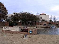
Carrollton Municipal Complex | |
 Location in Dallas County and the state of Texas | |
| Coordinates: 32°59′24″N 96°53′36″W / 32.99000°N 96.89333°WCoordinates: 32°59′24″N 96°53′36″W / 32.99000°N 96.89333°W | |
| Country | United States |
| State | Texas |
| Counties | Denton, Dallas, Collin |
| Government | |
| • Type | Council-Manager |
| • City Council |
Mayor Matthew Marchant (R) Jeff Andonian Doug Hrbacek Bob Garza Kevin Falconer Terry Simons Lisa Sutter Anthony Wilder |
| • City Manager | Leonard Martin |
| Area | |
| • City | 37.1 sq mi (96.1 km2) |
| • Land | 36.3 sq mi (94.0 km2) |
| • Water | 0.8 sq mi (2.1 km2) 2.19% |
| Elevation | 528.1 ft (161 m) |
| Population (2013) | |
| • City | 126,700 |
| • Density | 3,400/sq mi (1,300/km2) |
| • Metro | 6,810,913 |
| Time zone | Central (UTC-6) |
| • Summer (DST) | Central (UTC-5) |
| ZIP codes | 75006, 75007, 75008, 750 |
| Area code(s) | 972 |
| FIPS code | 48-13024[1] |
| GNIS feature ID | 1332207[2] |
| Website | http://www.cityofcarrollton.com |
Carrollton is a city in Denton County, Dallas County and Collin County, Texas. As of the 2010 census, its population was 119,097 making it the twenty-third most populous city in Texas.[3]
History
The area was first settled by Jared Ford in 1842 by William and Mary Larner on a site within the Peters Colony grant. In 1844, the A. W. Perry family claimed land in the area around Trinity Mills, where, in partnership with Wade H. Witt, a mill was established.[4]
The English colony, a group of families in the northeastern area of settlement which crossed into Denton County, was home to large landowners including the Furneaux, Jackson, Morgan, and Rowe families. It is most likely that Carrollton was named for Carrollton, Illinois, the original home of many of these settlers.[4]
Early on, Carrollton's livelihood was exclusively agricultural, but following the construction of the Dallas-Wichita Railroad through Trinity Mills in 1878, the community began to grow in its industrial significance. Carrollton's significance was further strengthened when the railroad was extended to Denton in 1880 by Jay Gould, who sold the line to the Missouri–Kansas–Texas Railroad (the Katy) in 1881. By 1885, Carrollton had flour mills, cotton gins, two churches, a school, and a population of 150. The St. Louis Southwestern Railway (the "Cotton Belt") crossed the Katy in 1888, and the town became a shipping center for livestock, cotton, cottonseed, and grain, helping the town surpass Trinity Mills to the north.[4]
In 1913 Carrollton was officially incorporated, and W.F. Vinson was elected mayor. A gravel industry that began in Carrollton in 1912 transformed the city, by the late 1940s, to a "grain and gravel" town. The city also supported a brick plant and a dairy industry, and National Metal Products established itself in the city in 1946.[4]
After World War II the city grew rapidly. In 1950 its population stood at 1,610, and it grew to 4,242 in 1960 and 13,855 in 1970. At this point, significant suburban growth began spilling out of north Dallas, and the city grew tremendously between 1970 and 1980, with a documented growth of 193% to 40,595 inhabitants. By 1983, the population was 52,000, by 1990, it had reached 82,169, and by 2010 the population had grown to 119,097.[3][4]
It is a suburb of Dallas and in 2006 was named to America's "Top 100 Places to Live" by Relocate America.[5] Also in 2006, it was selected as the 19th best place to live in the United States by Money magazine.[6] In 2008 it was named by Money magazine the 15th best place to live among small cities.[7]
Geography and environment
According to the United States Census Bureau, Carrollton has a total area of 37.1 square miles (96.1 km2), of which 36.3 square miles (94.0 km2) is land and 0.81 square miles (2.1 km2), or 2.19%, is water.[8] Carrollton is located in portions of three counties: Dallas County, Denton County and Collin County.
| Carrollton, Texas | ||||||||||||||||||||||||||||||||||||||||||||||||||||||||||||
|---|---|---|---|---|---|---|---|---|---|---|---|---|---|---|---|---|---|---|---|---|---|---|---|---|---|---|---|---|---|---|---|---|---|---|---|---|---|---|---|---|---|---|---|---|---|---|---|---|---|---|---|---|---|---|---|---|---|---|---|---|
| Climate chart (explanation) | ||||||||||||||||||||||||||||||||||||||||||||||||||||||||||||
| ||||||||||||||||||||||||||||||||||||||||||||||||||||||||||||
| ||||||||||||||||||||||||||||||||||||||||||||||||||||||||||||

Climate
On average, the warmest month is July. The highest recorded temperature was 112 °F in 1980. The average coolest month is January. The lowest recorded temperature was 1 °F in 1989. The most precipitation on average occurs in May. Carrollton is considered to have a humid subtropical climate.
Demographics
| Historical population | |||
|---|---|---|---|
| Census | Pop. | %± | |
| 1920 | 573 | — | |
| 1930 | 689 | 20.2% | |
| 1940 | 921 | 33.7% | |
| 1950 | 1,610 | 74.8% | |
| 1960 | 4,242 | 163.5% | |
| 1970 | 13,855 | 226.6% | |
| 1980 | 40,595 | 193.0% | |
| 1990 | 82,169 | 102.4% | |
| 2000 | 109,576 | 33.4% | |
| 2010 | 119,097 | 8.7% | |
| Est. 2015 | 133,168 | [9] | 11.8% |
As of the 2010 census, the total population was 119,097, with 43,299 households and 31,073 families residing in the city. The population density was 3,209.8 people per square mile (1,239.3/km2). There were 45,508 housing units at an average density of 1,253.7 per square mile (484.1/km2). The racial makeup of the city was 63.6% White, 8.4% African American, 0.6% Native American, 13.4% Asian, 0.03% Pacific Islander, 10.8% some other race, and 3.1% from two or more races. Hispanic or Latino of any race were 30.0% of the population.[3]
There were 43,299 households at the 2010 census. Of these, 35.9% had children under the age of 18 living with them, 71.8% were headed by married couples living together, 12.4% had a female householder with no husband present, and 28.2% were non-families. 22.5% of all households were made up of individuals, and 4.6% had someone living alone who was 65 years of age or older. The average household size was 2.74, and the average family size was 3.25.[3]
In the city the population was spread out with 26.0% under the age of 18, 8.5% from 18 to 24, 29.7% from 25 to 44, 27.8% from 45 to 64, and 8.0% who were 65 years of age or older. The median age was 35.6 years. For every 100 females there were 95.7 males. For every 100 females age 18 and over, there were 92.4 males.[3]
At the 2010 census, the median income for a household in the city was $70,960 and the median income for a family was $68,672. Males had a median income of $45,469 versus $32,997 for females. The per capita income for the city was $26,746. About 4.1% of families and 5.6% of the population were below the poverty line, including 7.4% of those under age 18 and 6.3% of those age 65 or over.
Government
Local government
According to the city's most recent Comprehensive Annual Financial Report, the city's various funds had $80,591,584 in Revenues, $79,091,366 in expenditures, $26,674,276 in total assets, $3,006,754 in total liabilities, and $22,950,199 in cash and investments.[11]
The city of Carrollton is a voluntary member of the North Central Texas Council of Governments association, the purpose of which is to coordinate individual and collective local governments and facilitate regional solutions, eliminate unnecessary duplication, and enable joint decisions.
Economy
| # | Employer | # of Employees |
|---|---|---|
| 1 | Halliburton Energy Services | 1,302 |
| 2 | McKesson | 833 |
| 3 | Hilton Reservations Worldwide | 900 |
| 4 | Baylor Medical Center at Carrollton | 700 |
| 5 | RealPage | 679 |
| 6 | RIA | 650 |
| 7 | Accor North America | 514 |
| 8 | Western Extrusions | 501 |
| 9 | General Aluminum | 490 |
| 10 | AER Manufacturing | 374 |
The city houses headquarters for:
- FASTSIGNS International, Inc.[13]
- Halliburton has North America operations for Easywell in Carrollton.[14]
- Heelys, Inc.[15]
- Jokari
- Motel 6
- RealPage, Inc.
- Sandy Lake Amusement Park
Law and government

The City of Carrollton has a City Council that consists of seven members and a Mayor, the current Mayor of Carrollton is Matthew Marchant.[16] The City Council is responsible for establishing city policies, considering city resolutions and ordinances, appointing citizens to various city boards and commissions, adopting the city's Comprehensive Plan and annual budget, approving or rejecting zoning changes, and meets on the first and third Tuesday of every month.
Education
Most of Carrollton is a part of the Carrollton-Farmers Branch Independent School District. Dallas Independent School District also serves a small portion of Carrollton in the south, along with the Lewisville Independent School District in the north.
The DISD portion is served partially by Jerry R. Junkins Elementary School, Walker Middle School, and W. T. White High School. Private schools in the area include The Saint Anthony School, Carrollton Christian Academy. At one time Coram Deo Academy had a campus in Carrollton.[17]
The Japanese School of Dallas, a supplementary Japanese school, conducts its classes at Ted Polk Middle School in Carrollton.[18] The school has its main offices in Farmers Branch.[18][19]
Responsive Education Solutions has two charter schools in Carrollton. Carrollton Classic Academy, grades K-5, which holds classes at First Baptist Church, and Quest of Coppell, grades 6-8, which holds classes at The North Church.
Notable people
- Sam Garza, professional soccer player.
- Rhema Marvanne, child gospel singer featured in the movie Machine Gun Preacher[20]
- Jason Maxiell, Detroit Pistons forward player, attended Newman Smith High School[21]
- Katie Meili, Olympian swimmer who won Gold and Bronze Medals at the 2016 Summer Olympics.[22]
- Keith Moreland, Professional baseball player and broadcaster. He attended R.L. Turner.
- Noah Ringer, Taekwondo champion and The Last Airbender actor[23]
- Melissa Rycroft, former Dallas Cowboys cheerleader and Dancing with the Stars and The Bachelor contestant[24]
- Ron Simmons, investment advisor in Carrollton and Republican member of the Texas House of Representatives since 2013[25]
- Burt Solomons, Denton County lawyer; Republican member of the Texas House of Representatives from District 65 from 1995-2013[26]
- Taylor Teagarden, Baltimore Orioles catcher, attended Creekview High School[27]
- Corbin Van Arsdale, former member of the Texas House of Representatives from Harris County, 2003-2008; reared in Carrollton; lawyer and lobbyist in Austin
- Deron Williams, point guard for the Dallas Mavericks, attended Arbor Creek Middle School
- Travis Wilson, wide receiver for the Cleveland Browns, attended Creekview High School[28]
- Vanilla Ice, rapper and reality TV star. He attended R.L. Turner.
- Amanda Bouldin, from Carrollton, a New Hampshire politician
- Rafael Cruz, father of Ted Cruz, US Senator from Texas and 2016 Presidential candidate
Sister Cities
References
- ↑ "American FactFinder". United States Census Bureau. Archived from the original on 2013-09-11. Retrieved 2008-01-31.
- ↑ "US Board on Geographic Names". United States Geological Survey. 2007-10-25. Retrieved 2008-01-31.
- 1 2 3 4 5 "Profile of General Population and Housing Characteristics: 2010 Demographic Profile Data (DP-1): Carrollton city, Texas". U.S. Census Bureau, American Factfinder. Archived from the original on September 11, 2013. Retrieved January 11, 2012.
- 1 2 3 4 5 Carrollton, Texas from the Handbook of Texas Online. By Joan Jenkins Perez. Retrieved 4 February 2007.
- ↑ Relocate America - Carrollton, Texas. Retrieved 8 November 2006.
- ↑ "MONEY Magazine: Best places to live 2006: Top 100 1-25". Money.cnn.com. Retrieved 2013-07-22.
- ↑ "Best places to live 2008". CNN.
- ↑ "Geographic Identifiers: 2010 Demographic Profile Data (G001): Carrollton city, Texas". U.S. Census Bureau, American Factfinder. Archived from the original on September 11, 2013. Retrieved January 11, 2012.
- ↑ "Annual Estimates of the Resident Population for Incorporated Places: April 1, 2010 to July 1, 2015". Retrieved July 2, 2016.
- ↑ "Census of Population and Housing". Census.gov. Archived from the original on May 11, 2015. Retrieved June 4, 2015.
- ↑ "City of Carrollton CAFR 2013". Retrieved 2014-02-15.
- ↑ City of Carrollton CAFR Retrieved 2009-07-20
- ↑ "Fastsigns International, Inc. Moves to Largar Facility in Carrollton, TX". Franchisewire.com. Retrieved 2013-07-22.
- ↑ Easywell Offices." Hallburton. Retrieved on April 3, 2009.
- ↑ Sheryl Jean (April 25, 2011). "Carrollton-based Heelys tries to get back on track". The Dallas Morning News.
- ↑ Sandoval, Stephanie (2008-05-11). "Challenger Ron Branson ousts Becky Miller in Carrollton mayor's race". The Dallas Morning News. Retrieved 2008-05-12.
- ↑ "Coram Deo Academy of North Dallas." Coram Deo Academy. Retrieved on October 12, 2011. "2435 E. Hebron Pkwy. Carrollton, TX 75007"
- 1 2 "学校紹介." Japanese School of Dallas. Retrieved on March 30, 2014. "学校所在地 JAPANESE SCHOOL OF DALLAS C/O TED POLK MIDDLE SCHOOL 2001 KELLY BLVD. CARROLLTON, TEXAS 75006" and "事務局所在地 JAPANESE SCHOOL OF DALLAS 4100 ALPHA RD. SUITE 917 DALLAS, TEXAS 75244"
- ↑ "City of Farmers Branch District Zoning Map" (Archive). City of Farmers Branch. Adopted February 24, 1969 (updated March 2013); retrieved April 26, 2015.
- ↑ Eric Aasen. "Young Texas girl becomes singing sensation online". Abilene Reporter-News.
- ↑ "Jason Maxiell NBA profile". Nba.com. 1983-02-18. Retrieved 2013-07-22.
- ↑ "Katie Meili Swimming". Team USA. Retrieved August 9, 2016.
- ↑ Bruce Felps (July 2, 2010). "From Local Kid to Movie Star, Back Again". KXAS-TV.
- ↑ "DWTS' Melissa: Born to Dance!". Star.
- ↑ "Ron Simmons' Biography". votesmart.com. Retrieved March 15, 2014.
- ↑ "Burt Rowe Solomons". lrl.state.tx.us. Retrieved September 22, 2013.
- ↑ "Taylor Teagarden ESPN profile". Sports.espn.go.com. Retrieved 2013-07-22.
- ↑ Scott Crisp (July 28, 2009). "Cowboys Release Wilson". KXAS-TV.
- ↑ "Dallas County forging closer ties with Taiwan". Press Reader. Dallas Morning News. Retrieved 2 November 2016.
External links
| Wikimedia Commons has media related to Carrollton, Texas. |
- Official website
- Carrollton, Texas from the Handbook of Texas Online
- Headlines about Carrollton and Farmers Branch from The Dallas Morning News
 |
Lewisville (8 miles) |
The Colony (2 miles) |
Plano (14 miles) |
|
| Coppell (6 miles) |
|
Addison (6 miles) | ||
| ||||
| | ||||
| Irving (13 miles) |
Farmers Branch (4 miles) |
Dallas (18 miles) |
Municipalities and communities of Collin County, Texas, United States | ||
|---|---|---|
| Cities | 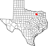 | |
| Towns | ||
| CDP | ||
| Other unincorporated communities |
| |
| Historical communities | ||
| Ghost towns | ||
| Footnotes | ‡This populated place also has portions in an adjacent county or counties | |
Municipalities and communities of Dallas County, Texas, United States | ||
|---|---|---|
| Cities | 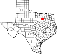 | |
| Towns | ||
| Unincorporated communities | ||
| Historical communities | ||
| Footnotes | ‡This populated place also has portions in an adjacent county or counties | |
Municipalities and communities of Denton County, Texas, United States | ||
|---|---|---|
| Cities |  | |
| Towns | ||
| CDPs | ||
| Unincorporated communities | ||
| Ghost towns | ||
| Footnotes | ‡This populated place also has portions in an adjacent county or counties | |

| ||
| ||