Gauchin-Légal
| Gauchin-Légal | |
|---|---|
 Gauchin-Légal | |
|
Location within Hauts-de-France region  Gauchin-Légal | |
| Coordinates: 50°24′56″N 2°34′58″E / 50.4156°N 2.5828°ECoordinates: 50°24′56″N 2°34′58″E / 50.4156°N 2.5828°E | |
| Country | France |
| Region | Hauts-de-France |
| Department | Pas-de-Calais |
| Arrondissement | Béthune |
| Canton | Houdain |
| Intercommunality | Artois |
| Government | |
| • Mayor (2014–2020) | Claude Lemaitre |
| Area1 | 6.03 km2 (2.33 sq mi) |
| Population (2012)2 | 337 |
| • Density | 56/km2 (140/sq mi) |
| Time zone | CET (UTC+1) |
| • Summer (DST) | CEST (UTC+2) |
| INSEE/Postal code | 62366 / 62150 |
| Elevation |
85–167 m (279–548 ft) (avg. 93 m or 305 ft) |
|
1 French Land Register data, which excludes lakes, ponds, glaciers > 1 km² (0.386 sq mi or 247 acres) and river estuaries. 2 Population without double counting: residents of multiple communes (e.g., students and military personnel) only counted once. | |
Gauchin-Légal (or Gauchin-le-Gal) is a commune in the Pas-de-Calais department in the Hauts-de-France region of France.
Geography
A farming village situated some 10 miles (16.1 km) south of Béthune and 29 miles (46.7 km) southwest of Lille, at the junction of the D73 and the D341 roads. A small stream, the ‘ruisseau Caucourt’, a tributary of the river Lawe, flows through the village.
Population
| Year | 1962 | 1968 | 1975 | 1982 | 1990 | 1999 | 2012 |
|---|---|---|---|---|---|---|---|
| Population | 271 | 272 | 245 | 227 | 296 | 331 | 337 |
| From the year 1962 on: No double counting—residents of multiple communes (e.g. students and military personnel) are counted only once. | |||||||
Places of interest
- "Le Gal", a sandstone rock chained to another on the village square.
- The church of St. Joseph, dating from the sixteenth century.
- The eighteenth-century château.
 Le gal de Gauchin
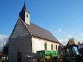 The church
 Monument to war dead
See also
References
External links
| Wikimedia Commons has media related to Gauchin-Légal. |
- Gauchin-Légal on the Quid website (French)
This article is issued from Wikipedia - version of the 11/6/2016. The text is available under the Creative Commons Attribution/Share Alike but additional terms may apply for the media files.