Arrondissement of Béthune
| Arras | |
|---|---|
| Arrondissement of France | |
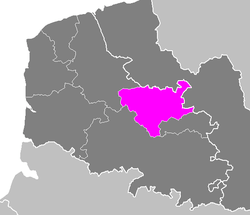 Location of Béthune in Nord-Pas-de-Calais | |
| Country | France |
| Region | Hauts-de-France |
| Department | Pas-de-Calais |
| Communes | 100 |
| Subprefecture | Béthune |
| Area¹ | |
| • Total | 673.82 km2 (260.16 sq mi) |
| Population (2013) | |
| • Total | 285,789 |
| • Density | 420/km2 (1,100/sq mi) |
| ¹ French Land Register data, which exclude lakes, ponds, and glaciers larger than 1 km² as well as the estuaries of rivers. | |
The arrondissement of Béthune is an arrondissement of France in the Pas-de-Calais department in the Hauts-de-France region. It has 100 communes.
Composition
Cantons
The cantons of the arrondissement of Béthune are:
- Aire-sur-la-Lys (partly)
- Auchel (partly)
- Béthune
- Beuvry
- Bruay-la-Buissière (partly)
- Douvrin
- Lillers
- Nœux-les-Mines (partly)
Communes
The communes of the arrondissement of Béthune, and their INSEE codes, are:
| 1. Allouagne (62023) | 2. Ames (62028) | 3. Amettes (62029) | 4. Annequin (62034) |
| 5. Annezin (62035) | 6. Auchel (62048) | 7. Auchy-au-Bois (62049) | 8. Auchy-les-Mines (62051) |
| 9. Béthune (62119) | 10. Barlin (62083) | 11. Beugin (62120) | 12. Beuvry (62126) |
| 13. Billy-Berclau (62132) | 14. Blessy (62141) | 15. Bourecq (62162) | 16. Bruay-la-Buissière (62178) |
| 17. Burbure (62188) | 18. Busnes (62190) | 19. Calonne-Ricouart (62194) | 20. Calonne-sur-la-Lys (62195) |
| 21. Camblain-Châtelain (62197) | 22. Cambrin (62200) | 23. Cauchy-à-la-Tour (62217) | 24. Caucourt (62218) |
| 25. Chocques (62224) | 26. Cuinchy (62262) | 27. Divion (62270) | 28. Douvrin (62276) |
| 29. Drouvin-le-Marais (62278) | 30. Ecquedecques (62286) | 31. Essars (62310) | 32. Estrée-Blanche (62313) |
| 33. Estrée-Cauchy (62314) | 34. Ferfay (62328) | 35. Festubert (62330) | 36. Fleurbaix (62338) |
| 37. Fouquereuil (62349) | 38. Fouquières-lès-Béthune (62350) | 39. Fresnicourt-le-Dolmen (62356) | 40. Gauchin-Légal (62366) |
| 41. Givenchy-lès-la-Bassée (62373) | 42. Gonnehem (62376) | 43. Gosnay (62377) | 44. Guarbecque (62391) |
| 45. Haillicourt (62400) | 46. Haisnes (62401) | 47. Ham-en-Artois (62407) | 48. Hermin (62441) |
| 49. Hesdigneul-lès-Béthune (62445) | 50. Hinges (62454) | 51. Houchin (62456) | 52. Houdain (62457) |
| 53. Isbergues (62473) | 54. La Couture (62252) | 55. Labeuvrière (62479) | 56. Labourse (62480) |
| 57. Lambres (62486) | 58. Lapugnoy (62489) | 59. Laventie (62491) | 60. Lespesses (62500) |
| 61. Lestrem (62502) | 62. Lières (62508) | 63. Liettres (62509) | 64. Ligny-lès-Aire (62512) |
| 65. Lillers (62516) | 66. Linghem (62517) | 67. Locon (62520) | 68. Lorgies (62529) |
| 69. Lozinghem (62532) | 70. Maisnil-lès-Ruitz (62540) | 71. Marles-les-Mines (62555) | 72. Mazinghem (62564) |
| 73. Mont-Bernanchon (62584) | 74. Nœux-les-Mines (62617) | 75. Neuve-Chapelle (62606) | 76. Norrent-Fontes (62620) |
| 77. Noyelles-lès-Vermelles (62626) | 78. Oblinghem (62632) | 79. Ourton (62642) | 80. Quernes (62676) |
| 81. Rebreuve-Ranchicourt (62693) | 82. Rely (62701) | 83. Richebourg (62706) | 84. Robecq (62713) |
| 85. Rombly (62720) | 86. Ruitz (62727) | 87. Sailly-Labourse (62735) | 88. Sailly-sur-la-Lys (62736) |
| 89. Saint-Floris (62747) | 90. Saint-Hilaire-Cottes (62750) | 91. Saint-Venant (62770) | 92. Vaudricourt (62836) |
| 93. Vendin-lès-Béthune (62841) | 94. Vermelles (62846) | 95. Verquigneul (62847) | 96. Verquin (62848) |
| 97. Vieille-Chapelle (62851) | 98. Violaines (62863) | 99. Westrehem (62885) | 100. Witternesse (62900) |
External links
Coordinates: 50°32′00″N 2°38′00″E / 50.5333°N 2.6333°E
This article is issued from Wikipedia - version of the 11/18/2016. The text is available under the Creative Commons Attribution/Share Alike but additional terms may apply for the media files.