Avesnes-le-Comte
| Avesnes-le-Comte | ||
|---|---|---|
 | ||
| ||
 Avesnes-le-Comte | ||
|
Location within Hauts-de-France region  Avesnes-le-Comte | ||
| Coordinates: 50°16′39″N 2°31′46″E / 50.2775°N 2.5294°E / 50.2775; 2.5294Coordinates: 50°16′39″N 2°31′46″E / 50.2775°N 2.5294°E / 50.2775; 2.5294 | ||
| Country | France | |
| Region | Hauts-de-France | |
| Department | Pas-de-Calais | |
| Arrondissement | Arras | |
| Canton | Avesnes-le-Comte | |
| Intercommunality | Atrébatie | |
| Government | ||
| • Mayor (2008–2014) | Jean Picque | |
| Area1 | 9.38 km2 (3.62 sq mi) | |
| Population (2009)2 | 2,085 | |
| • Density | 220/km2 (580/sq mi) | |
| Time zone | CET (UTC+1) | |
| • Summer (DST) | CEST (UTC+2) | |
| INSEE/Postal code | 62063 / 62810 | |
| Elevation |
99–154 m (325–505 ft) (avg. 152 m or 499 ft) | |
|
1 French Land Register data, which excludes lakes, ponds, glaciers > 1 km² (0.386 sq mi or 247 acres) and river estuaries. 2 Population without double counting: residents of multiple communes (e.g., students and military personnel) only counted once. | ||
.svg.png)
Avesnes-le-Comte is a commune in the Pas-de-Calais department in northern France.
Geography
A small farming town located 11 miles (17 km) west of Arras at the junction of the D8, D75 and D339 roads.
Population
| Historical population | ||
|---|---|---|
| Year | Pop. | ±% |
| 1962 | 1,388 | — |
| 1968 | 1,424 | +2.6% |
| 1975 | 1,490 | +4.6% |
| 1982 | 1,835 | +23.2% |
| 1990 | 2,011 | +9.6% |
| 1999 | 1,983 | −1.4% |
| 2009 | 2,085 | +5.1% |
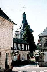
Sights
- The motte of a 12th-century castle.
- The church of St. Nicholas, with the apse dating from the twelfth century.
- The town hall, built in 1830.
- An ancient cemetery.
- The war memorial.
See also
References
External links
| Wikimedia Commons has media related to Avesnes-le-Comte. |
- Avesnes-le-Comte on the Quid website (French)
This article is issued from Wikipedia - version of the 10/22/2016. The text is available under the Creative Commons Attribution/Share Alike but additional terms may apply for the media files.