Villers-Châtel
| Villers-Châtel | |
|---|---|
.jpg) | |
 Villers-Châtel | |
|
Location within Hauts-de-France region  Villers-Châtel | |
| Coordinates: 50°22′38″N 2°35′17″E / 50.3772°N 2.5881°E / 50.3772; 2.5881Coordinates: 50°22′38″N 2°35′17″E / 50.3772°N 2.5881°E / 50.3772; 2.5881 | |
| Country | France |
| Region | Hauts-de-France |
| Department | Pas-de-Calais |
| Arrondissement | Arras |
| Canton | Aubigny-en-Artois |
| Intercommunality | Communauté de communes de l'Atrébatie |
| Government | |
| • Mayor (2008–2014) | Maurice Brisset |
| Area1 | 3.17 km2 (1.22 sq mi) |
| Population (2006)2 | 122 |
| • Density | 38/km2 (100/sq mi) |
| Time zone | CET (UTC+1) |
| • Summer (DST) | CEST (UTC+2) |
| INSEE/Postal code | 62857 / 62690 |
| Elevation |
111–159 m (364–522 ft) (avg. 147 m or 482 ft) |
|
1 French Land Register data, which excludes lakes, ponds, glaciers > 1 km² (0.386 sq mi or 247 acres) and river estuaries. 2 Population without double counting: residents of multiple communes (e.g., students and military personnel) only counted once. | |
Villers-Châtel is a commune in the Pas-de-Calais department in the Hauts-de-France region of France.
Geography
Villers-Châtel is situated some 13 miles (20.9 km) northwest of Arras, at the junction of the D73E road.
Population
| Year | 1962 | 1968 | 1975 | 1982 | 1990 | 1999 | 2006 |
|---|---|---|---|---|---|---|---|
| Population | 83 | 106 | 76 | 92 | 115 | 123 | 122 |
| From the year 1962 on: No double counting—residents of multiple communes (e.g. students and military personnel) are counted only once. | |||||||
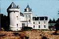
Places of interest
- The chateau, dating from the fourteenth century.
See also
References
External links
| Wikimedia Commons has media related to Villers-Châtel. |
- Villers-Châtel on the Quid website (French)
.jpg)
This article is issued from Wikipedia - version of the 11/8/2016. The text is available under the Creative Commons Attribution/Share Alike but additional terms may apply for the media files.