Tortequesne
| Tortequesne | ||
|---|---|---|
 | ||
| ||
 Tortequesne | ||
|
Location within Hauts-de-France region  Tortequesne | ||
| Coordinates: 50°17′24″N 3°02′23″E / 50.29°N 3.0397°ECoordinates: 50°17′24″N 3°02′23″E / 50.29°N 3.0397°E | ||
| Country | France | |
| Region | Hauts-de-France | |
| Department | Pas-de-Calais | |
| Arrondissement | Arras | |
| Canton | Vitry-en-Artois | |
| Intercommunality | Osartis | |
| Government | ||
| • Mayor (2008–2014) | André Martin | |
| Area1 | 3.37 km2 (1.30 sq mi) | |
| Population (2006)2 | 723 | |
| • Density | 210/km2 (560/sq mi) | |
| Time zone | CET (UTC+1) | |
| • Summer (DST) | CEST (UTC+2) | |
| INSEE/Postal code | 62825 / 62490 | |
| Elevation |
36–71 m (118–233 ft) (avg. 42 m or 138 ft) | |
|
1 French Land Register data, which excludes lakes, ponds, glaciers > 1 km² (0.386 sq mi or 247 acres) and river estuaries. 2 Population without double counting: residents of multiple communes (e.g., students and military personnel) only counted once. | ||

Tortequesne is a commune in the Pas-de-Calais department in the Hauts-de-France region of France.
Geography
Tortequesne is surrounded by lakes and marshland, 13 miles (20.9 km) east of Arras, at the junction of the D43 and D956 roads and on the border with the department of Nord.
Population
| Year | 1962 | 1968 | 1975 | 1982 | 1990 | 1999 | 2006 |
|---|---|---|---|---|---|---|---|
| Population | 415 | 489 | 504 | 578 | 719 | 686 | 723 |
| From the year 1962 on: No double counting—residents of multiple communes (e.g. students and military personnel) are counted only once. | |||||||
Places of interest
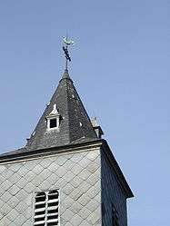
- The church of St. Martin, dating from the nineteenth century.
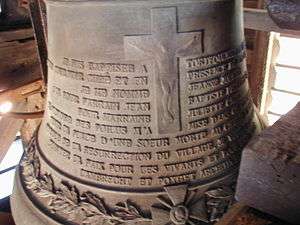
‘Jeanne-Juliette’, the church bell, installed in 1923
See also
References
External links
| Wikimedia Commons has media related to Tortequesne. |
- Tortequesne official website (French)
- Tortequesne on the Quid website (French)
This article is issued from Wikipedia - version of the 11/8/2016. The text is available under the Creative Commons Attribution/Share Alike but additional terms may apply for the media files.