Aix-Noulette
| Aix-Noulette | ||
|---|---|---|
 | ||
| ||
 Aix-Noulette | ||
|
Location within Hauts-de-France region  Aix-Noulette | ||
| Coordinates: 50°25′36″N 2°42′38″E / 50.4267°N 2.7106°ECoordinates: 50°25′36″N 2°42′38″E / 50.4267°N 2.7106°E | ||
| Country | France | |
| Region | Hauts-de-France | |
| Department | Pas-de-Calais | |
| Arrondissement | Lens | |
| Canton | Sains-en-Gohelle | |
| Intercommunality | Lens-Liévin | |
| Government | ||
| • Mayor (2008–2014) | Alain Lefèbvre | |
| Area1 | 10.44 km2 (4.03 sq mi) | |
| Population (2009)2 | 3,798 | |
| • Density | 360/km2 (940/sq mi) | |
| Time zone | CET (UTC+1) | |
| • Summer (DST) | CEST (UTC+2) | |
| INSEE/Postal code | 62019 / 62160 | |
| Elevation |
57–172 m (187–564 ft) (avg. 75 m or 246 ft) | |
|
1 French Land Register data, which excludes lakes, ponds, glaciers > 1 km² (0.386 sq mi or 247 acres) and river estuaries. 2 Population without double counting: residents of multiple communes (e.g., students and military personnel) only counted once. | ||

Aix-Noulette is a commune in the Pas-de-Calais department in the Hauts-de-France region of France.
Geography
A farming and light industrial village situated some 5 miles (8.0 km) west of Lens at the junction of the D937 and D165 roads. Junction 6.1 of the A26 autoroute is within the borders of the commune.
Population
| Historical population | ||
|---|---|---|
| Year | Pop. | ±% |
| 1962 | 2,637 | — |
| 1968 | 2,660 | +0.9% |
| 1975 | 3,358 | +26.2% |
| 1982 | 3,093 | −7.9% |
| 1990 | 3,661 | +18.4% |
| 1999 | 3,836 | +4.8% |
| 2009 | 3,798 | −1.0% |
Sights
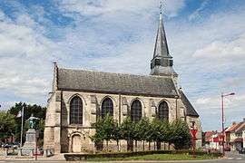
- The church of St.Germain, dating from the 13th century.
- The feudal motte.
- Remains of a medieval castle.
- The three Commonwealth War Graves Commission cemeteries.
See also
- Communes of the Pas-de-Calais department
- The Église Saint-Germain d’Aix-Noulette has Georges Saupique statues of St Barbara and St Nicholas.
References
External links
| Wikimedia Commons has media related to Aix-Noulette. |
- Aix-Noulette Communal Cemetery Extension - CWGC cemetery
- Bois de Noulette British Cemetery - CWGC cemetery
- Tranchee de Mecknes Cemetery - CWGC cemetery
- Aix-Noulette on the Quid website (French)
- Website of the Communaupole de Lens-Liévin (French)
This article is issued from Wikipedia - version of the 11/6/2016. The text is available under the Creative Commons Attribution/Share Alike but additional terms may apply for the media files.