Sains-en-Gohelle
| Sains-en-Gohelle | |
|---|---|
|
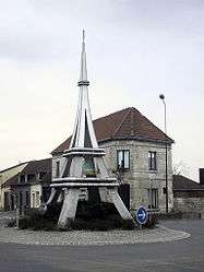
Model of the Eiffel Tower at the crossroads | |
 Sains-en-Gohelle | |
|
Location within Hauts-de-France region  Sains-en-Gohelle | |
| Coordinates: 50°26′43″N 2°41′04″E / 50.4453°N 2.6844°ECoordinates: 50°26′43″N 2°41′04″E / 50.4453°N 2.6844°E | |
| Country | France |
| Region | Hauts-de-France |
| Department | Pas-de-Calais |
| Arrondissement | Lens |
| Canton | Sains-en-Gohelle |
| Intercommunality | Communaupole de Lens-Liévin |
| Government | |
| • Mayor (2008–2014) | Jean-Luc Wéry |
| Area1 | 5.73 km2 (2.21 sq mi) |
| Population (2006)2 | 3,106 |
| • Density | 540/km2 (1,400/sq mi) |
| Time zone | CET (UTC+1) |
| • Summer (DST) | CEST (UTC+2) |
| INSEE/Postal code | 62737 / 62114 |
| Elevation |
39–90 m (128–295 ft) (avg. 79 m or 259 ft) |
|
1 French Land Register data, which excludes lakes, ponds, glaciers > 1 km² (0.386 sq mi or 247 acres) and river estuaries. 2 Population without double counting: residents of multiple communes (e.g., students and military personnel) only counted once. | |
Sains-en-Gohelle is a commune in the Pas-de-Calais department in the Hauts-de-France region of France.
Geography
Sains-en-Gohelle is an ex-coalmining town, nowadays a farming and light industrial commune, 6 miles (9.7 km) northwest of Lens, at the junction of the D937 and the D166 roads. The A26 autoroute passes through the town.
Population
| Year | 1962 | 1968 | 1975 | 1982 | 1990 | 1999 | 2006 |
|---|---|---|---|---|---|---|---|
| Population | 5250 | 5342 | 5189 | 5587 | 6034 | 6084 | 6106 |
| From the year 1962 on: No double counting—residents of multiple communes (e.g. students and military personnel) are counted only once. | |||||||
Places of interest
- The church of St.Vaast, dating from the twelfth century.
- The modern church of Saint Marguerite.
See also
References
External links
| Wikimedia Commons has media related to Sains-en-Gohelle. |
- Official town website (French)
- Website of the Communaupole de Lens-Liévin(French)
- Sains-en-Gohelle on the Quid website (French)
This article is issued from Wikipedia - version of the 11/8/2016. The text is available under the Creative Commons Attribution/Share Alike but additional terms may apply for the media files.