Agnez-lès-Duisans
| Agnez-lès-Duisans | ||
|---|---|---|
 | ||
| ||
 Agnez-lès-Duisans | ||
|
Location within Hauts-de-France region  Agnez-lès-Duisans | ||
| Coordinates: 50°18′30″N 2°39′36″E / 50.3083°N 2.66°E / 50.3083; 2.66Coordinates: 50°18′30″N 2°39′36″E / 50.3083°N 2.66°E / 50.3083; 2.66 | ||
| Country | France | |
| Region | Hauts-de-France | |
| Department | Pas-de-Calais | |
| Arrondissement | Arras | |
| Canton | Beaumetz-lès-Loges | |
| Intercommunality | Val de Gy | |
| Government | ||
| • Mayor (2008–2014) | Pascal Coin | |
| Area1 | 7.3 km2 (2.8 sq mi) | |
| Population (2009)2 | 688 | |
| • Density | 94/km2 (240/sq mi) | |
| Time zone | CET (UTC+1) | |
| • Summer (DST) | CEST (UTC+2) | |
| INSEE/Postal code | 62011 / 62161 | |
| Elevation |
67–111 m (220–364 ft) (avg. 70 m or 230 ft) | |
|
1 French Land Register data, which excludes lakes, ponds, glaciers > 1 km² (0.386 sq mi or 247 acres) and river estuaries. 2 Population without double counting: residents of multiple communes (e.g., students and military personnel) only counted once. | ||

Agnez-lès-Duisans is a commune in the Pas-de-Calais department in northern France.
Geography
A farming village located 4 miles (6 km) west of Arras, at the D62 and D56 road junction.
Population
| Historical population | ||
|---|---|---|
| Year | Pop. | ±% |
| 1962 | 386 | — |
| 1968 | 397 | +2.8% |
| 1975 | 415 | +4.5% |
| 1982 | 507 | +22.2% |
| 1990 | 561 | +10.7% |
| 1999 | 650 | +15.9% |
| 2009 | 688 | +5.8% |
Sights
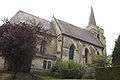
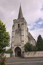
- The church of St.Martin, dating from the fifteenth century.
- The remains of an old castle.
- Two 18th century farm buildings.
See also
Communes of the Pas-de-Calais department
References
External links
| Wikimedia Commons has media related to Agnez-lès-Duisans. |
This article is issued from Wikipedia - version of the 10/5/2016. The text is available under the Creative Commons Attribution/Share Alike but additional terms may apply for the media files.