Bours, Pas-de-Calais
| Bours | |
|---|---|
 | |
 Bours | |
|
Location within Hauts-de-France region  Bours | |
| Coordinates: 50°27′19″N 2°24′21″E / 50.4553°N 2.4058°E / 50.4553; 2.4058Coordinates: 50°27′19″N 2°24′21″E / 50.4553°N 2.4058°E / 50.4553; 2.4058 | |
| Country | France |
| Region | Hauts-de-France |
| Department | Pas-de-Calais |
| Arrondissement | Arras |
| Canton | Heuchin |
| Intercommunality | Pernois |
| Government | |
| • Mayor (2008–2014) | Bernadette Noe |
| Area1 | 11.84 km2 (4.57 sq mi) |
| Population (2009)2 | 571 |
| • Density | 48/km2 (120/sq mi) |
| Time zone | CET (UTC+1) |
| • Summer (DST) | CEST (UTC+2) |
| INSEE/Postal code | 62166 / 62550 |
| Elevation |
83–184 m (272–604 ft) (avg. 171 m or 561 ft) |
|
1 French Land Register data, which excludes lakes, ponds, glaciers > 1 km² (0.386 sq mi or 247 acres) and river estuaries. 2 Population without double counting: residents of multiple communes (e.g., students and military personnel) only counted once. | |
Bours is a commune in the Pas-de-Calais department in the Hauts-de-France region in northern France.
Geography
A farming village located 20 miles (32 km) northwest of Arras on the D89 road, in the valley of the Clarence river.
Population
| Historical population | ||
|---|---|---|
| Year | Pop. | ±% |
| 1962 | 493 | — |
| 1968 | 545 | +10.5% |
| 1975 | 510 | −6.4% |
| 1982 | 505 | −1.0% |
| 1990 | 524 | +3.8% |
| 1999 | 509 | −2.9% |
| 2009 | 571 | +12.2% |
Sights
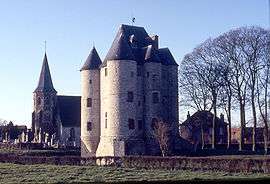
- The church of Sainte-Austreberthe, dating from the eleventh century.

- The (restored) castle donjon, also from the eleventh century. Built of sandstone by Hugues de Bours.
See also
References
External links
| Wikimedia Commons has media related to Bours, Pas-de-Calais. |
- Bours on the Quid website (French)
This article is issued from Wikipedia - version of the 11/6/2016. The text is available under the Creative Commons Attribution/Share Alike but additional terms may apply for the media files.